|
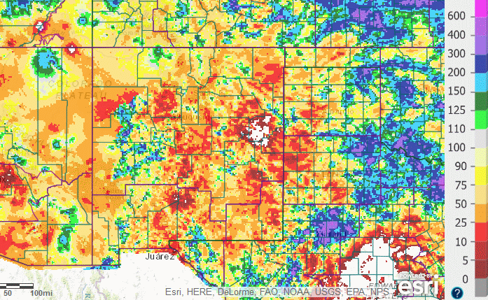
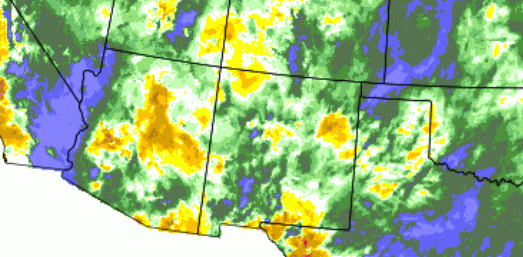
Calendar Year 2016 Precipitation
September 2016. The month produced above normal rainfall in across the southeast half of the state, while near to below normal precipitation fell over the northwest half. This resulted in the statewide average near normal, 98 percent of normal to be exact.
August 2016. The monsoon finally kicked in with a bang in the early days of the month and continued through the 10th, with most areas above to much above normal. The 10th through 20th were less active, but there were still locally heavy rain amounts. The 21st was a very wet day across the state, especially for the south. The exceptions to the above normal rainfall have been spotty, mainly in the east central portions of the state. Convection increased again over the last week of the month. This has resulted in most areas above normal for August. July 2016. July was relatively quiet. However, large hail and damaging winds struck parts of Harding County, including around Solano, Mosquero and Logan on the 3rd. Welcome rain finally fell over the east on the 14th and 15th. Some monsoon moisture made it into western and central portions of the state starting on the 17th and then continued through through the 23rd. A back door cold front on the 24th helped eastern areas receive some rain as well. The final week of the month was active with widespread showers and thunderstorms, and isolated minor flooding. Flash flooding occurred in Chilili on the evening of the 24th, due to debris from the Dog Head burn scar.
June 2016. The southeast half of NM fared the best, with the exception of the far southeast. Multiple rounds of locally heavy rainfall from thunderstorms across these areas of NM brought above normal precipitation for June. Northwest portions of the state largely missed out on the showers and storms. Statewide precipitation ended up just slightly below at 1.14 inches (normal is 1.17 inches).
May 2016. May started out with a bang across northern and central NM. Widespread rain and mountain snow impacted the area, especially from the Continental Divide westward from the 1st to the 3rd. A couple more fast moving systems crossed northern NM with scattered showers and thunderstorms on the 6th and 7th then again from the 9th through the 12th. The next round of precipitation began on the 17th and continued into the 19th. This has left much of western NM with above normal precipitation for May, while central, eastern and far southern portions of the state have been near to below normal. Heavy rain along the far eastern plains on the 31st help to bring precipitation near to above normal in small pockets of the east.
April 2016. The 1st day of the month was wet and white as a storm from late March departed. Most of the snow fell over the northern and central mountains, with rain in the lower elevations, especially across the southeast. Widespread rain and high mountain snow was welcomed on the 8th into the early morning of the 9th, favoring the southwest two-thirds of the state. Mostly dry weather occurred from the 10th through the 14th. Then a slow moving storrm brought much needed rain and mountain snow to the Land of Enchantment from the 15th through the 18th. An active weather pattern unsued through the rest of the month with several light to moderate rain and snow events. A majority of the state ended up with above normal precipitation.
March 2016. The weather pattern remained very dry for the large majority of New Mexico for the entire month of March. The only notable weather system for the month impacted the far northeast plains on the 26th when several inches of snow fell from near Angel Fire to Raton and Clayton. The prolonged stretch of dry weather since early January has set the stage for the re-development of drought across much of New Mexico. Several areas had not received a wetting precipitation event (greater than 0.10 inches) in about 10 weeks.
February 2016. Through the first few days of the month, decent snow fell over the west and north. But it was dry over the state from the 4th through the 21st, with mostly above normal temperatures, including a few days with record highs. Finally a storm system delivered rain and snow mainly to areas along and north of I-40 on the 22nd and 23rd. but this was followed by mostly dry weather with above normal tmperatures through the rest of the month.
January 2016. After an epic end to December 2015 over eastern New Mexico, precipitation through January 2016 was below normal over much of the east, central and west central areas. Above normal areas included the northwest, the Sangre de Cristo mountains and portions of the northeast highlands, the southwest deserts and south central mountains. A small but potent upper level disturbance early on the 25th delivered incredible snow amounts to a small area along the east slopes of the Sangre de Cristo mountains. Totals ranged from 18 to 30 inches in several spots. The statewide percent of normal precipitation for January was at 87 percent, 56th driest on record.
Calendar Year 2015 Precipitation Review
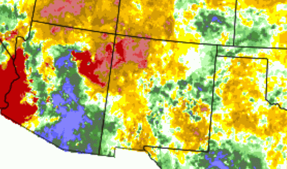
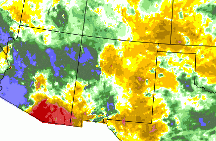
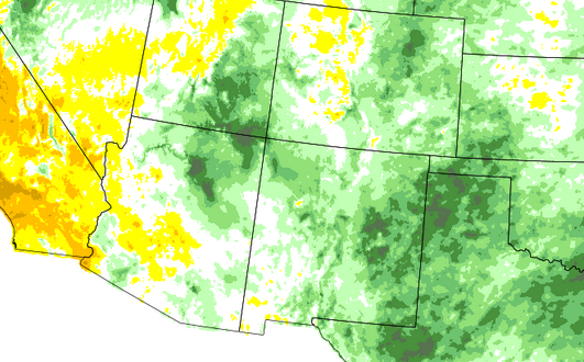
January - December 2015. Precipitation was near to above normal across all of New Mexico in 2015. The 12 month period from January through December ranked as the 5th wettest year on record, and the wettest since 1986. Spring 2015 snowmelt and subsequent runoff started early and was well below normal for the 5th year in a row. The well above normal temperatures through April were a major culprit for the receeding snowpack this spring. May arrived and a very active weather pattern ensued over central and eastern areas of the state. Nearly daily rounds of showers and thunderstorms produced heavy rainfall, some of which produced flash flooding over the eastern plains. June remained active with scattered to numerous showers and thunderstorms. Locally heavy rainfall impacted the northern high terrain where flash flooding was reported. Short-term drought conditions were cleared from the east while significant improvements were made to central and portions of western New Mexico. July saw the development of a robust monsoon pattern over the area with additional flash flooding. More heavy rainfall added to the already impressive yearly precipitation totals, especially the eastern plains where upwards of 15 to 25 inches of rain has fallen this year. The monsoon diminished in August and September as precipitation was mostly below normal, aside from portions of the eastern plains. October reversed the trend, providing New Mexico with mostly above to well above normal precipitation. Statewide average precipitation in October was 244 percent of normal! November was above normal, coming in at 121 percent. The first half of December 2015 started out dry with very few storms crossing the state. The end of the month made significant gains as a very active weather pattern returned to the state. We closed out the year with a historic blizzard event that buried much of east central and southeast New Mexico in 10 to 30 inches of snow. The graphic below is derived from the PRISM Drought Indicator Tool and shows the precipitation departure from normal (percent of average precipitation) for 2015. Most of the state was near to above normal, with portions of eastern New Mexico well above normal. For more detailed information on the PRISM precipitation analysis click here.
|