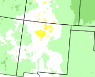
October 2018 produced temperatures pretty close to normal statewide. The far west and east tended to be a little below normal while central areas were a bit above normal. Precipitation was near normal in the west, above normal central and well above normal in the east. Albuquerque, Clayton and Roswell were all within the top 15 wettest Octobers on record.
The first half of October was exciting across the land of Enchantment with tropical moisture, strong cold fronts, high winds and snow all impacting portions of the state. The first significant storm impacted the state from Friday night, October 5th into Tuesday the 9th. A couple of back door cold fronts brought much chillier air to the east, and cooling to the west during this time. Meanwhile, a deep upper level closed low was taking shape over the Great Basin. It moved slowly east, gradually weakening and lifting northeast. Widespread showers and some thunderstorms erupted over NM, Dime size hail was reported near Roswell on the 6th and high winds from a thunderstorm hit Clines Corners on the 7th. Moisture from the remnants of Hurricane Sergio delivered welcome rain to southern portions of the state late on the 12th into the 13th. From tropical moisture to winter weather took place on the 14th through 18th. A powerful back door cold front, deepening storm system from the northwest, and developing storm to our west all combined to bring cold air, rain and northern high terrain snow to the state. A very wet storm system spilled widespread rain and high northern mountain snow onto NM from the 22nd through 24th. Another impressive storm closed out the month with widespread rain and mountain snow on the 30th into the early hours of Halloween.
Statewide Precipitation and Temperatures
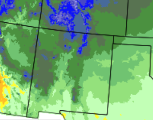
| Statewide Precipitation - Actual |
Statewide Temperatures - Actual
|
|
|
|
 |
 |
|
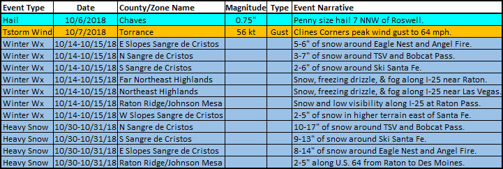
Statewide Precipitation - Percent Of Normal
|
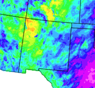
Statewide Temperatures - Departure From Normal |
|
|
|
 |
.png) |
Climate Cities Temperatures and Precipitation
| Albuquerque |
| |
|
There was 1.99 inches of precipitation measured at the Sunport in October 2018, compared to the normal of 1.02 inches, or 0.97 inches above normal. This was the 14th wettest October on record.
The average temperature for Albuquerque in October 2018 was 57.0°, which was 0.5 degrees below the normal of 57.5°.
The average maximum temperature for the month was 66.8°. This was 2.2 degrees below the normal average maximum temperature of 69.0°.
The average minimum temperature for the month was 47.1°. This was 1.0 degree above the normal average minimum temperature of 46.1 degrees.
Records: none
|
| |
| Clayton |
| |
|
There was 4.04 inches of precipitation measured at Clayton in October 2018, or 2.93 inches above the average of 1.11 inches. This was the 6th wettest October on record.
The average temperature for Clayton in October 2018 was 52.6°, which was 2.2 below the normal of 54.8°.
The average maximum temperature for the month was 64.5°. This was 4.0 degrees below the normal average maximum temperature of 68.5 degrees.
The average minimum temperature for the month was 40.7°. This was 0.4 degrees below the normal average minimum temperature of 41.1°.
Records: 7th - record daily rainfall - 1.78 inches. 14th - record low 24 degrees.
|
| |
| Roswell |
| |
|
There was 3.25 inches of precipitation reported at Roswell during October of 2018, which is 2.02 inches above the normal of 1.23 inches. This was the 15th wettest October on record.
The average temperature in Roswell for October 2018 was 61.6°, which is 0.5 degrees above the normal of 61.1 degrees.
The average maximum temperature for the month was 72.4°. This was 3.3 degrees below the average maximum temperature of 75.7 degrees.
The average minimum temperature for the month was 50.7°. This was 4.2 degrees above the normal average minimum temperature of 46.5°
Records: 3rd - record daily high - 97 degrees. 5th - record daily high - 94 degrees
|