
A Recipe for Heavy Rain
|
|||||||||||||||||||||||||||||||||
|
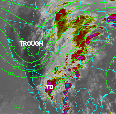
What are the necessary "ingredients" for widespread heavy rain in New Mexico? Abundant atmospheric moisture and a mechanism to lift the moisture are obvious answers. During the week of September 21st, 2010, the necessary features for such an event came into place over the desert southwest. An upper level trough of low pressure positioned along the west coast of California on September 21st moved east toward New Mexico through the 22nd. Meanwhile Tropical Storm Georgette was developing rapidly along the western Mexican coastline near the southern tip of Baja California on the 21st. Abundant tropical moisture began surging north into New Mexico as deep south to southwest flow developed ahead of the approaching upper level trough. The first illustration below is the infrared satellite imagery valid on the afternoon of the 22nd. The brighter red and purplish colors indicate very cold cloud tops corresponding to heavy showers and thunderstorms. The green lines indicate the 500mb height contours or a mid atmospheric pressure pattern. As Tropical Storm Georgette pushed onshore Baja California it weakened slowly to a tropical depression. The remnants of Georgette have been labeled "TD" over northern Sonora.
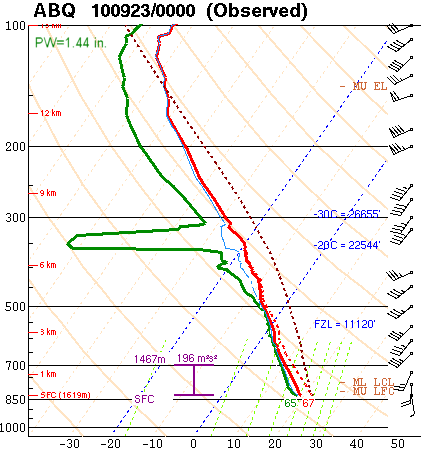
The amount of moisture available in the atmosphere to produce rainfall can be measured in several ways. The National Weather Service releases weather balloons twice daily all across the country to measure weather parameters through the atmosphere, including moisture content. The graphic below is the result of the atmospheric sounding produced on September 22nd at 600pm at Albuquerque. The red line indicates temperature and the green line dewpoint. The closer these two lines are together the more moisture there is available for heavy rainfall. With the exception of a thin dry layer around 6km this is an extremely moist sounding for Albuquerque. In fact, the 1.44 inches of precipitable water was a record amount for September and the third highest value recorded for all months since 1948! A second image depicting the values of precipitable water from September 20-24 using the NOAA/GSD GPS-MET system clearly depicts the dramatic increase to our record-breaking value late on the 22nd.
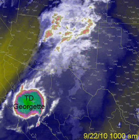
The following illustration is a satellite loop captured between 1000am and 800pm on the 22nd. One can clearly see the impressive area of tropical moisture associated with the remnants of Tropical Storm Georgette moving northeast out of Sonora toward New Mexico. The upper level trough moving in from the west as indicated by the more yellowish colors served as a lifting mechanism to produce widespread heavy rainfall across New Mexico on the 22nd.
The table below outlines some of the more impressive rainfall totals received for this record event. Many thanks to all our spotters who provided us with many detailed and timely precipitation amounts during this significant weather event!
|
|||||||||||||||||||||||||||||||||

