 |
|||||||||||||
|
October can be an ideal month for outdoor events. The thunderstorm season has waned and the jet stream is usually still situated to our north. However, on rare occasions, remnants of land-falling tropical systems from the eastern Pacific or western Gulf of America can bring surges of moisture into the state, particularly early in the month. Also, weather systems moving far enough south through the Rocky Mountain region can and do bring strong winds, cooler than normal temperatures and widespread precipitation, including snow! Severe weather, while not common, can occur as it did in 2004. Always check the latest NWS forecast for the Albuquerque Metro Area prior to attending an outdoor event. A weather phenomenon known as the "Albuquerque Box" produces an atmospheric wind pattern that results in balloons remaining over the park during the morning hours. Read more about the Albuquerque Box below.
The data listed below includes over 40 years of minimum and maximum temperatures, peak wind gusts, precipitation days and amounts, and average relative humidity for the first fifteen days of October at the Albuquerque International Sunport. Note: Due to its valley location, morning low temperatures at Balloon Fiesta Park can often be 5 to 10 degrees cooler than at the airport, while daytime maximum temperatures are 1 to 3 degrees warmer. Wind can also vary considerably between the Sunport and the Balloon Fiesta Park since complex terrain features to the east of Albuquerque often result in microscale circulation patterns.
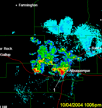
October 4-5, 2004 was especially memorable along the Middle Rio Grande Valley, including the Albuquerque Metro Area, as numerous severe thunderstorms struck the region on the night of the 4th, between 1000 pm and 100 am and again on the afternoon of the 5th. One of the more damaging storms hit northwest Albuquerque and Rio Rancho at 12:30 am on the 5th. Paradise Hills was especially hard hit with significant large hail accumulation and damage. |
|||||||||||||
|
Temperature Extremes, Precipitation, Wind, & Humidity Data |
|||||||||||||
|
Year |
Lowest
Min T |
Highest
Min T |
Lowest
Max T |
Highest
Max T |
Average Wind (mph) |
Peak Wind Gust (mph) |
# of days with precip. (T or >)
|
Average Relative Humidity |
Total Precip. (inches) |
|
1974
|
41
|
56
|
59
|
80
|
8.5 | 34 |
8
|
60
|
0.97 |
|
1975
|
34
|
48
|
66
|
83
|
9.3 | 31 |
0
|
31
|
0.00 |
|
1976
|
30
|
59
|
60
|
81
|
8.7 | 43 |
2
|
36
|
T |
|
1977
|
38
|
60
|
63
|
82
|
9.4 | 34 |
2
|
47
|
0.75 |
|
1978
|
38
|
57
|
67
|
89
|
9.1 | 43 |
1
|
35
|
T |
|
1979
|
38
|
58
|
78
|
91
|
7.6 | 34 |
1
|
28
|
T |
|
1980
|
38
|
55
|
64
|
90
|
9.2 | 38 |
3
|
38
|
0.07 |
|
1981
|
43
|
56
|
65
|
76
|
9.4 | 34 |
4
|
56
|
1.39 |
|
1982
|
31
|
51
|
58
|
83
|
8.6 | 28 |
2
|
40
|
0.24 |
|
1983
|
42
|
54
|
65
|
78
|
8.8 | 28 |
4
|
59
|
0.86 |
|
1984
|
34
|
54
|
47
|
78
|
7.5 | 42 |
6
|
61
|
2.34 |
|
1985
|
40
|
54
|
63
|
81
|
8.4 | 32 |
6
|
56
|
1.37 |
|
1986
|
31
|
51
|
38
|
80
|
10.2 | 32 |
7
|
62
|
1.49 |
|
1987
|
44
|
54
|
69
|
85
|
8.1 | 44 |
2
|
35
|
0.16 |
|
1988
|
43
|
54
|
67
|
81
|
7.8 | 33 |
5
|
51
|
0.32 |
|
1989
|
45
|
58
|
55
|
85
|
7.1 | 36 |
4
|
48
|
0.92 |
|
1990
|
36
|
56
|
61
|
80
|
7.7 | 35 |
2
|
41
|
0.09 |
|
1991
|
42
|
54
|
75
|
86
|
6.7 | 32 |
0
|
32
|
0.00 |
|
1992
|
35
|
53
|
69
|
84
|
4.5 | 38 |
0
|
23
|
0.00 |
|
1993
|
43
|
52
|
69
|
87
|
8.3 | 41 |
4
|
39
|
0.20 |
|
1994
|
41
|
57
|
62
|
85
|
7.0 | 52 |
4
|
42
|
0.74 |
|
1995
|
40 | 53 | 65 | 82 | 6.6 | 40 | 0 | 26 | 0.00 |
| 1996 | 50 | 56 | 60 | 83 | 6.6 | 44 | 3 | 47 | 0.69 |
| 1997 | 35 | 59 | 67 | 85 | 9.0 | 49 | 5 | 42 | 0.26 |
| 1998 | 36 | 59 | 55 | 83 | 8.3 | 38 | 1 | 32 | 0.06 |
| 1999 | 43 | 57 | 62 | 83 | 7.3 | 48 | 2 | 31 | T |
| 2000 | 38 | 57 | 42 | 89 | 8.7 | 44 | 8 | 59 | 1.42 |
| 2001 | 33 | 58 | 62 | 83 | 8.4 | 39 | 5 | 36 | 0.14 |
| 2002 | 42 | 58 | 62 | 80 | 8.1 | 39 | 2 | 38 | T |
| 2003 | 45 | 63 | 66 | 82 | 7.3 | 35 | 7 | 53 | 1.58 |
| 2004 | 34 | 56 | 59 | 77 | 7.3 | 44 | 7 | 58 | 0.73 |
| 2005 | 43 | 62 | 54 | 81 | 7.6 | 56 | 9 | 59 | 0.78 |
| 2006 | 43 | 61 | 62 | 82 | 8.0 | 38 | 5 | 50 | 1.70 |
| 2007 | 40 | 56 | 64 | 83 | 6.6 | 39 | 3 | 37 | 0.17 |
| 2008 | 38 | 60 | 53 | 82 | 8.2 | 58 | 4 | 45 | 1.38 |
| 2009 | 42 | 57 | 62 | 81 | 8.7 | 45 | 4 | 37 | 0.21 |
| 2010 | 47 | 63 | 72 | 86 | 6.8 | 37 | 5 | 40 | 0.09 |
| 2011 | 38 | 57 | 59 | 81 | 6.3 | 43 | 4 | 46 | 1.44 |
| 2012 | 40 | 58 | 65 | 87 | 7.4 | 49 | 2 | 31 | T |
| 2013 | 38 | 52 | 62 | 83 | 8.7 | 60 | 2 | 33 | 0.04 |
| 2014 | 38 | 58 | 64 | 83 | 7.7 | 67 | 5 | 37 | 0.16 |
| 2015 | 48 | 65 | 67 | 88 | 8.2 | 66 | 6 | 46 | 0.11 |
| 2016 | 44 | 58 | 62 | 85 | 6.9 | 38 | 3 | 42 | 0.74 |
| 2017 | 36 | 63 | 62 | 82 | 6.8 | 42 | 3 | 46 | 0.04 |
| 2018 | 33 | 61 | 42 | 85 | 9.6 | 45 | 9 | 54 | 0.28 |
| 2019 | 36 | 66 | 61 | 79 | 44 | 2 | 0.58 | ||
| Average | 39.4 | 56.8 | 61.6 | 83.1 | 7.9 | 41 | 3.8 days | 43% | 0.61" |
Weather Patterns Associated with the Albuquerque Box
|
||||||||||||
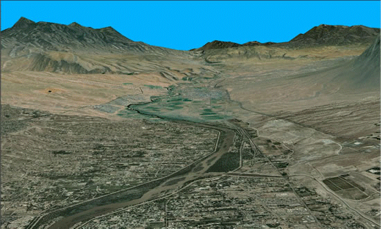
| The Albuquerque box is essentially a valley wind pattern which develops under certain "stable" conditions. During the nighttime hours, the air near the ground is cooled by the process of radiation cooling. This process is most efficient with clear skies, low humidity and light wind. Cooler, and therefore more dense, air flows downslope and pools at lower elevations such as along arroyos and river valleys - as depicted in by the white arrows in the figure below. The cool air that pools in the Rio Grande valley is shallow (generally no more than a few hundred feet in depth). During the early morning hours this "drainage wind" flows from north to south down the valley from higher to lower elevations much as any fluid flows downhill. In much of the Albuquerque metro area, including the balloon park, a north wind of generally less than 10 mph can result. | ||||||||||||
 |
||||||||||||
|
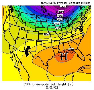
Above the surface, the flow of the air is controlled by synoptic patterns in the atmosphere. The figure to the right depicts the 700 millibar heights, or pressure pattern around 5000 feet above the surface, on October 5th, 2002. High pressure over the southeast states has resulted in a weak southerly flow over central New Mexico. |
 |
|||||||||||
|
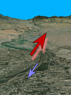
The stable "river of air" or drainage wind described above occurs below a temperature inversion which separates it from warmer, less dense air above the inversion, just as vinegar is separated from oil by differences in density. The wind direction in the airmass above the shallow inversion can be different than that below the inversion. In an "ideal" box pattern, the wind blows in exactly the opposite direction, with a north wind at the surface (blue arrow) and a south wind above the surface (red arrow), as shown in the figure to the right. A skillful pilot can bring a balloon back to near the point of takeoff by changing altitudes to ride wind currents in different directions. Upon takeoff the pilot first heads south toward downtown, then ascends higher where the winds will take the balloon back north toward the balloon fiesta grounds. |
 |
|||||||||||
|
The photo to the right, taken during the 2007 Balloon Fiesta, nicely depicts the low level drainage winds. The photo was taken to the west, and the flags at the north end of Balloon Fiesta Park indicate a north to south wind. On this day, winds aloft were out of the south and southwest. (Photo by J. Wachter) |
 |
|||||||||||
|
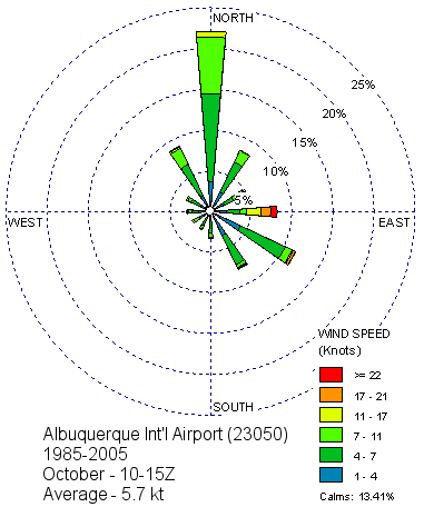
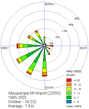
This wind pattern for which the Albuquerque area is well known occurs under stable conditions during the fall season when generally no strong weather systems are affecting the area. A local study found that on average the "box" circulation occurs about 3 days out of the first 15 days of October. A more recent check of the past 10 years found that the "box" occurs on average about twice between October 5th and 15th. Even on days when the "box" occurs, it dissipates by mid morning as the sun heats the ground, resulting in thermal turbulence which mixes the lower layers of air and eliminates the low level inversion. Wind roses can help to illustrate the difference in wind patterns from morning to afternoon. The wind roses below depict the frequency and speed of the wind from 12 compass directions. It is important to note that they represent wind measured at the Albuquerque Sunport. |
||||||||||||
|
This wind rose depicts the distribution of the wind in October 1985 through 2005, during the early to mid morning hours (900am to 1100am MDT). This wind rose illustrates the persistence of the nocturnal drainage wind in the Rio Grande Valley. Cooler surface air becomes more dense and flows downvalley. While this graphic represents the wind data from the Albuquerque Sunport, the wind at the balloon fiesta grounds is similar though the drainage wind is likely stronger, due to the lower elevation and proximity to the Rio Grande. |
 |
|||||||||||
|
This wind rose is also for October, but represents the afternoon hours 100pm through 500 pm MDT. By afternoon, the drainage wind is gone, having been mixed out. The winds tend to become more southwesterly, and usually have higher speeds than the north drainage wind. Both wind roses illustrate that while winds from the east do not occur frequently during the morning or afternoon, when they do occur the wind speeds are generally strong, often reaching speeds greater than 20 knots. |
 |
|||||||||||

