National Weather Service United States Department of Commerce


Every year we receive inquiries regarding our chances for a "White Christmas." As you can imagine, the definition of a White Christmas can vary, depending on who you ask. For some, a solid snow cover on Christmas Day under bright blue New Mexico sunshine would qualify. For others, it means seeing snowflakes on Christmas Day, regardless of whether there's snow on the ground. And for the snow hounds, it means seeing snowflakes and having snow on the ground!

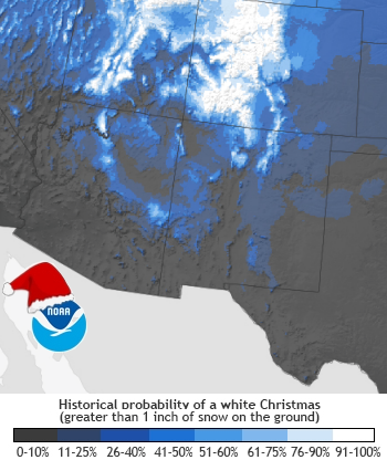
The chances for a White Christmas in Albuquerque and other lower elevation locations across central and northern New Mexico are not good, as shown in the image to the right produced by the National Centers for Environmental Information (NCEI). The image depicts the probability of having at least one inch of snow on the ground on Christmas Day. At the Albuquerque International Airport, for example, a Christmas snowfall (measurable) has occurred, on average, once every 16 years since snowfall records began at or near the airport (1931). You can check out the national probabilities from the National Centers for Environmental Information.

Obviously, the higher in elevation and farther north you are in New Mexico, the better your chances for experiencing a White Christmas. But just how much better? The table below shows the various probabilities for a half dozen communities: Red River, Gallup, the Albuquerque International Sunport (ABQ), Clayton, Chama and Roswell.

NCDC white christmas probabilities for southwest u.s.
 
Christmas Day Red River Gallup  ABQ Clayton Chama Roswell

Elevation (feet)

8676' 6801' 5314' 4969' 7871' 3669'
Period of record (years) 112 46 127 106 113 88
Probability of seeing snowflakes 17% 13% 5% 4% 23% 8%
Probability of having any snow on the ground 78% 27% 3% 10% 74% 5%
Probability of seeing snowflakes and having snow on the ground 13% 4% <1% <1% 17% <1%
Average high temperature 37 42 45 48 37 53
Average low temperature 3 10 22 20 7 23
 

It's important to note that the period of record varies among these stations, which makes it difficult to make accurate comparisons.  However, generally speaking, winter storms that track across central or southern New Mexico, and tap low level moisture from the Gulf of America, tend to produce the heaviest and most widespread snows, particularly over the eastern plains. This may explain the fact that the probability of seeing snowflakes in Roswell is slightly better than in Albuquerque.

What's the forecast for your location on Christmas Day this year?

The 2017 Christmas Day snow cover, as well as the Christmas Day snow cover since 2005, is depicted in the charts below. Snow cover Christmas 2017 was sparse, with the only snow cover in the San Juan Mountains. Snow cover in December 25, 2016 was mostly in the northwest and north central mountains, which had a decent snow pack building.  Lighter snow cover existed over the western high terrain, particularly on the Chuska Mountains.  Snow cover was limited to the northern mountains and adjacent northeast highlands in 2014, with more of the state seeing a white Christmas in 2013 and 2012. December 2011 was an active month, with winter storms early in the month and in the week prior to Christmas day, such that much of New Mexico was treated to a white Christmas. 2011 was the last year when snow covered the ground over a vast majority of the state.  Snow on the 23rd and 24th of 2009 also resulted in much of the state having a white Christmas.  Christmas Day 2008 had two feet or more of snow over the northern and western high terrain, while in 2007 snow cover was confined to the western and northern mountains.  In 2006 Christmas Day fell between two major snow storms in New Mexico. Widespread snow coverage of less than 2 inches remained on Christmas Day. Christmas Day 2005 had only limited areas over extreme northern New Mexico with snow on the ground.

These charts also help to show that for New Mexico, the higher the terrain, the greater the chance of at least one inch of snow on the ground. For most of the high elevations, the chances of snow on the ground (50 to 80%) exceed the chances of seeing it snow (15 to 20%).  For locations at lower elevations, such as Albuquerque, Roswell, Clovis and Gallup, the probability of seeing snow (4-15%) slightly exceeds the chances of having an inch of snow on the ground (2-13%). 

12/25 Snow Cover 2004 - 2017


The figures above were obtained at the NWS National Operational Hydrologic Remote Sensing Center. At this site, you can monitor snow coverage, snow depth and snow water equivalent. Visit the web site and generate your own images for different areas of the county or for any day since 2002.


Here are the "Snow on Christmas" events at and near the Albuquerque International Airport since official record-keeping began in 1892:

2010s 2018 Light snow developed over the Four Corners region on Christmas Day then spread east across northern New Mexico through Christmas night. Snowfall amounts ranged from six to 10 inches across the northern mountains to three to six inches around Santa Fe and Raton. U.S. 64 was closed west of Raton due to extremely slick travel and numerous accidents were reported around Santa Fe. Two to five inches of snow fell in Albuquerque the day after Christmas.
  2016 Snow spread across northern and western New Mexico on Christmas Eve then into central and eastern New Mexico on Christmas Day. Many folks woke up to a white Christmas with at least light snow accumulations. Six to 12 inches fell over the northern mountains. Blizzard conditions were reported at Taos Ski Valley with heavy snow and wind gusts up to 105 mph at Kachina Peak. A trace of snow fell in Albuquerque.
  2015 A winter storm approaching from Arizona on Christmas Day developed into a major blizzard across New Mexico on the 26th and 27th. Travel across eastern New Mexico was shut down for days, including I-40 from Tijeras Canyon all the way to Texas. A civil emergency was declared for several counties across eastern New Mexico as heavy snow and high winds resulted in drifts up to 10 feet in some places. Rescue crews assisted almost 500 stranded motorists. Power outages effected over 30,000 customers due to downed power lines and roof collapses. Two people died in the storm, including nearly 50,000 livestock across eastern New Mexico. Losses from this blizzard exceeded 400 million dollars. Around two inches of snow fell in the Albuquerque metro area.
  2014 Snow developed over northwestern NM late on Christmas Day then spread east across the northern mountains and the high plains of eastern New Mexico through the morning of the 26th. Snowfall amounts ranged from 6 to 12 inches over the high terrain with 3 to 6 inches along I-40 from the Sandia Mountains to Clines Corners. Light snow fell around the Albuquerque metro area with less than two inches of accumulation.
  2011 An active weather pattern the week before Christmas resulted in White Christmas conditions for much of the state. In Albuquerque, lower elevations were snow free but several inches remained in the foothills on Christmas Day.
2000s 2009 A storm delivered snow to most of the state from later on the 22nd into early Christmas Eve morning, leaving at least 75% of the state with snow on the ground for Christmas Day. The Albuquerque foothills reported around an inch of snow, while the Sunport reported a trace.
2007 A fast-moving storm brought snow to the state on Christmas and by late evening, much of the eastern plains had new snow on the ground as well as gusty north to northeast winds producing blowing snow and drifts. However, there was no snow in the Albuquerque area.
2006 Limited areas across the Northeast Highlands received a few inches of snow on Christmas Day, and Cloudcroft received a trace. In Albuquerque, however, the big snow waited for a few days after Christmas, when a record 16.3 inches fell over a two-day period on December 29 and 30.
2003 Temperatures statewide were near or above normal with generally quiet weather.  A disturbance clipped northern New Mexico on the 26th, bringing light rain and high elevation snow showers to the northern and west central mountains.  No significant snow accumulations were observed.
2002 A storm system affected the Land of Enchantment from late on the 22nd through the 24th.  This storm moved slowly over southern California to northern Baja on the 22nd, then turned northeast toward New Mexico.  The storm brought a trace of snow to Albuquerque on Christmas Eve.
2000 A white Christmas indeed. Light snow fell across the Albuquerque Metro Area on Christmas Day, but temperatures were just a little too warm for it to accumulate. Only trace amounts were measured at the airport and  along the foothills.  However, it was a different story Christmas night and the day after (26th).  A strong storm intensified as it moved over central New Mexico, dumping 6.1 inches of snow at Albuquerque's airport on the 26th.  The foothills reported 7 inches, while the East Mountain communities were buried in 8 to 10 inches of snow.
1990s 1999 It snowed 1 inch between 7AM and noon on Christmas Day at the Albuquerque Foothills NE weather observation station. A mix of rain and snow was observed a the airport totaling 0.02 inches of precipitation for the day.
1997 Only a trace of snow remained on the ground at the airport on Christmas Day from the stormy period of December 20-23.   Snow depth at the Albuquerque Foothills NE was 6 inches.
1990 There was 1" of snow at the airport on Christmas Day.  This was left over from a storm a few days earlier.   Christmas was cold, with a high temperature of 28 and a low of zero.  This was the first event at the new Albuquerque Foothills NE weather station.  At that location (near Tramway/Montgomery), snow depth from earlier storms was 11" at 5 PM on the 24th, and still 9" at 5 PM on Christmas Day.
1980s  1987 It snowed 0.4" on Christmas Eve.   Flurries fell on Christmas Day with a high temperature of 25 degrees.
1983  It snowed 0.8" on Christmas Day.
1982 A trace of snow fell on Christmas Day but melted as the temperature reached 39 degrees.
1970s 1975 It snowed 0.3" on the night before Christmas.
1974 It began snowing Christmas afternoon.   Just over half an inch (0.6") had accumulated at the airport by late afternoon, and the storm total was 3.5" when the event ended later that night.
1960s 1962 It snowed 1" on Christmas Day.
1950s 1957 It snowed 2.9" on the night before Christmas at the airport, and probably more than that over most of the city.  This event was probably pretty close to the "ideal" white Christmas portrayed in the movies.
1952 It snowed 0.2" on the 21st, 0.6" on the 23rd, and 0.1" on Christmas Eve.  It didn't snow on Christmas Day but the high temperature was only 29 (the low was 14).  Consequently, the ground was still "somewhat" white.
1940s 1948 A trace of snow fell on Christmas Day.
1945 A trace of snow fell on Christmas Day.
1930s 1939 It snowed 0.3" at the airport on Christmas Day.  Once again, other areas of the city (or what is now the city) probably had more.
1920s 1924 It snowed 3" on the 24th.  Snow remained pretty much intact on Christmas Day as the high temperature was 21 and the low was 8 below zero.
1923 A trace of snow fell on Christmas Day.
1910s 1914 It snowed 6" from 7 AM till 7 PM on Christmas Eve.  Since the weather station was near downtown at that time, the area that now represents the Far Northeast Heights and Foothills probably got buried in that one!
1911 It snowed 2" from 6 AM till 10 AM on Christmas Day  with the temperature hovering at 30 degrees.
1900s 1905 It snowed 1" on Christmas Day.   The high temperature was 29 and the low was 4.
  1901 A trace of snow fell on Christmas Day.