National Weather Service United States Department of Commerce
Click a location below for detailed forecast.

Last Map Update: Fri, Feb 14, 2025 at 11:18:19 pm MST

Rain and snow will continue progressing eastward across the region through late Friday.
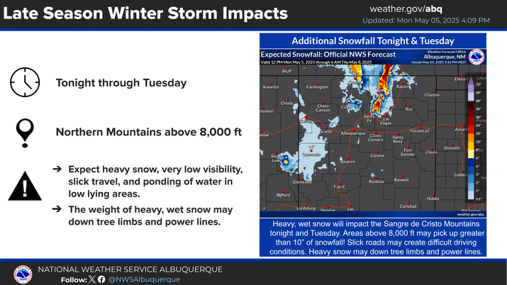
Heavy mountain snow is forecast through Saturday. Moderate to locally major travel impacts are expected in the northern mountains as a result, especially in the Tusas Mountains. Downed tree branches may result in power outages.
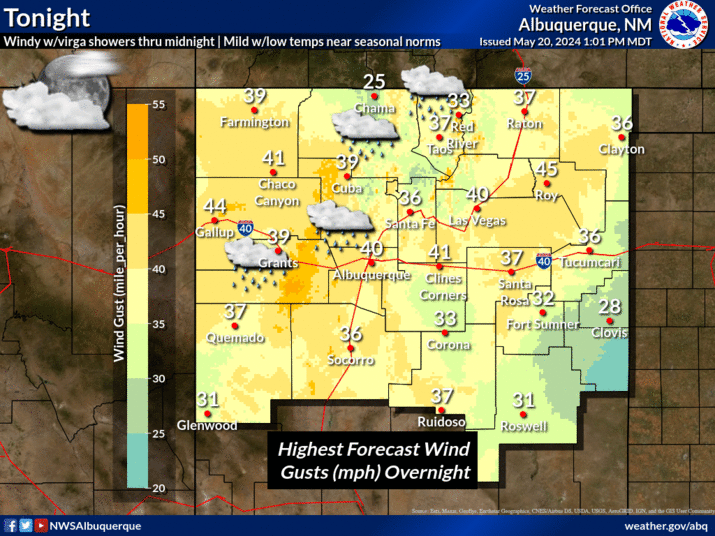
Gusty northwest winds with colder temperatures and scattered snow showers will make it feel very chilly Saturday. Watch for lingering slick travel impacts across northern NM.
A cold front will enter NM on Tuesday, bringing high probabilities for high temperatures below freezing Tuesday and Wednesday for eastern NM. The risk of frostbite and hypothermia increases with prolonged exposure to cold temps and wind chills.


Text Product Selector (Selected product opens in current window)


Submit Storm Report Icon

Submit Storm Report

Key Impacts Icon

Key Impacts

Observations Icon

Local Observations

Webcams Icon

Office Webcams

Satellite Icon

Satellite Imagery

Are You Prepared Icon

Are You Prepared?

Weekly Weather Briefing Icon

Weekly Weather Briefing

Area Forecast Discussion Icon

Area Forecast Discussion

Fire Weather Icon

Fire Weather

Aviation Weather Icon

Aviation Weather

Snow Probabilities Icon

Snow Probabilities

SKYWARN Icon

SKYWARN Spotters

On This Date in Weather History Icon

On This Date

Climate Graphs Icon

Climate Graphs

Drought Monitor Icon

Drought Monitor

Severe Weather Info and Climatology Icon

Severe Weather Climatology

Monsoon Awareness Icon

Monsoon Awareness

Winter Climatology Icon

Winter Climatology