National Weather Service United States Department of Commerce

The northern mountains will be the areas that see the largest accumulations of snow for the duration of this winter storm. Snow accumulations ranging from 5 to 10 inches with localized amounts greater than a foot will cause minor to moderate impacts.
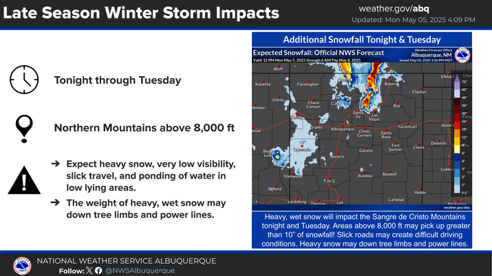
A storm system will cross the state late today through Saturday, bringing much needed precipitation. While rain is expected for most valley locations, significant late season snowfall is likely in the mountains. The peaks of the northern mountains could see snow amounts exceed one foot!
Well below average low temperatures are forecast Saturday night into Sunday morning. A late season light freeze is forecast in the middle RGV, including Albuquerque, and a Freeze Warning is in effect. Take action to protect sensitive vegetation.
A winter storm system will begin to make its way through the Four Corners tonight, bringing snowfall to western areas and the northern mountains. This system will cool temperatures to just below average for this time of year. Tomorrow's high look to be well below normal as well.


Text Product Selector (Selected product opens in current window)


Submit Storm Report Icon

Submit Storm Report

Key Impacts Icon

Key Impacts

Observations Icon

Local Observations

Webcams Icon

Office Webcams

Satellite Icon

Satellite Imagery

Are You Prepared Icon

Are You Prepared?

Weekly Weather Briefing Icon

Weekly Weather Briefing

Area Forecast Discussion Icon

Area Forecast Discussion

Fire Weather Icon

Fire Weather

Aviation Weather Icon

Aviation Weather

Snow Probabilities Icon

Snow Probabilities

SKYWARN Icon

SKYWARN Spotters

On This Date in Weather History Icon

On This Date

Climate Graphs Icon

Climate Graphs

Drought Monitor Icon

Drought Monitor

Severe Weather Info and Climatology Icon

Severe Weather Climatology

Monsoon Awareness Icon

Monsoon Awareness

Winter Climatology Icon

Winter Climatology