National Weather Service United States Department of Commerce

San Miguel Banner

Rainfall Summary: September 10-18, 2013

The table below is a comprehensive list of the more significant precipitation reports that were received for the 9-day event period.

Back to Historic Rainfall Feature

 Location (source) Precipitation Total (in)
 Las Vegas 8.4 NW (CoCoRaHS) 9.78
 Las Vegas 12.1 W (CoCoRaHS) 9.74
 Las Vegas 10.3 N (CoCoRaHS) 9.27
 Las Vegas 4.6 SSW (CoCoRaHS) 8.10
 Las Vegas 2.6 SE (CoCoRaHS) 7.49
 Rociada 5.6 E (CoCoRaHS) 7.04
 Pecos (RAWS) 6.45
 Sapello 5.1 WNW (CoCoRaHS) 6.45
 Las Vegas Airport (ASOS) 6.24
 Mosquero 15 SSE (CoCoRaHS) 4.32


Impact Summary
Location Date Summary

 Near Sabinoso

09/11/2013

NM 419 closed from mile markers 0 to 47 due to flooding of roadway.

Las Vegas

09/13/2013

Major flooding along Gallina Creek near Las Vegas. Evacuations ordered for areas along river from Montezuma east to Las Vegas. A major breach occurred on the Storrie Lake Diversion Channel and crews are working to restore channel. Estimated one year supply of water storage capacity lost for drinking water due to breach. A Red Cross shelter was established at Robertson High School. An elderly couple was rescued overnight by the National Guard from the Pine Camp area. NM 283 was closed west of Las Vegas. Sink hole reported near South Diversion River Crossing Catwalk with damage to waste water components. A couple homes and numerous vehicles and roadways damaged. A bridge on CR-A1 near Sapello was closed due to high water. A total of 1,040 structures were damaged in this multi-day event.

Near Pecos

09/13/2013

Pecos River breached banks in Pecos Canyon. NM 63 north of Pecos flooded and closed. Creek behind residences rising fast and evacuations possible.


Hydrologic Summary

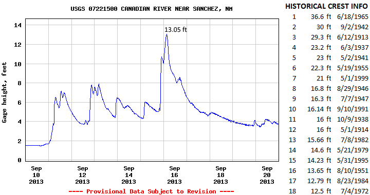
The Canadian River near Sanchez crested at 13.05 feet (10,000 cfs) at 315am MDT September 16, 2013.  This is now the 17th highest crest observed at this location.  This event compares to a previous crest of 13.65 feet on August 10, 1951 and 12.79 feet on August 23, 1984.  The record crest is 36.6 feet set back on June 18, 1965.  No significant flooding was observed immediately along the Canadian River however several nearby creeks and arroyos leading into this basin produced some flooding.  Action stage is 21 feet, minor flood stage 22 feet, moderate flood stage 26 feet, and major flood stage 30 feet.