| Rainfall Summary: September 10-18, 2013 | |||||||||||||||||||||||||||||||||||
|
The table below is a comprehensive list of the more significant precipitation reports that were received for the 9-day event period.
|
|||||||||||||||||||||||||||||||||||
| Impact Summary | |||||||||||||||||||||||||||||||||||

|
|||||||||||||||||||||||||||||||||||
|
Hydrologic Summary
|
|||||||||||||||||||||||||||||||||||
|
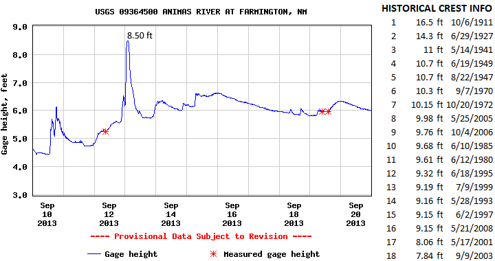
The Animas River at Farmington crested at 8.5 feet (5,620 cfs) at 200am MDT September 13, 2013. This is now the 17th highest crest observed at this location and compares to a previous crest of 9.15 feet on May 21, 2008 and 8.06 feet on May 17, 2001. The record crest is 16.5 feet set back on October 6, 1911. No significant flooding was observed along the Animas River, however several creeks and arroyos leading into this basin experienced flooding. Action stage is 9 feet, minor flood stage 10 feet, moderate flood stage 12 feet, and major flood stage 14 feet.
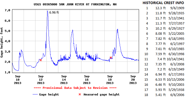
The San Juan River at Farmington crested at 6.96 feet (11,300 cfs) at 200am MDT September 13, 2013. This crest is now the 14th highest on record for this location and compares to a previous crest of 7.2 feet on June 19, 1949 and 6.94 feet on June 17, 1993. The record crest is 12.3 feet set back on September 6, 1909. No significant flooding was observed along the San Juan River, however several creeks and arroyos leading into this basin experienced flooding. Action stage is 7 feet , minor flood stage 8.5 feet, moderate stage 10 feet, and major stage 12 feet.
|
|||||||||||||||||||||||||||||||||||
|
Photos
|
|||||||||||||||||||||||||||||||||||
|
|
|||||||||||||||||||||||||||||||||||
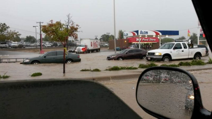
| Flooding started in the Northwest corner of the state on September 10th. Several roads in Farmington were closed due to flood waters. | |||||||||||||||||||||||||||||||||||