| Rainfall Summary: September 10-18, 2013 |
The table below is a comprehensive list of the more significant precipitation reports that were received for the 9-day event period.
Back to Historic Rainfall Feature
| Location (source) |
Precipitation Total (in) |
| Whitewater Creek (HADS) |
10.09 |
| Mogollon Baldy Lookout (HADS) |
6.80 |
| Mogollon (RAWS) |
6.78 |
| Hummingbird Saddle (HADS) |
5.87 |
| Mineral Creek (HADS) |
5.12 |
| Sheridan Corral (HADS) |
4.92 |
| Glenwood (COOP) |
4.63 |
| Pelona Mountain (RAWS) |
4.45 |
| Beaverhead (RAWS) |
3.86 |
| Gila National Forest (CRN) |
3.28 |
| Datil (RAWS) |
3.18 |
| Reserve (RAWS) |
3.10 |
| Bear Wallow Lookout (RAWS) |
2.77 |
| Luna Ranger Station (COOP) |
2.39 |
| Slaughter (RAWS) |
2.08 |
| Quemado (COOP) |
1.90 |
| Luna (RAWS) |
1.50 |
|
| Impact Summary |

| Location |
Date |
Summary |
|
Gila Cliff Dwellings
|
09/12-09/15/2013
|
Flooding along the Gila River caused closures of FR 614 into Lower Forks Campground and FR 528 into Grapevine Campground. Additional long duration heavy rainfall in the area forced the Gila River to rise 15 feet near the Gila Cliff Dwelling Monument with significant flooding. Access to monument and visitor center not possible. All campgrounds in the region closed, including Lower and Upper Scorpion. Five to 8 feet rapid water rise with debris in the Middle Fork Gila River near the Gila Cliff Dwellings Visitor Center. Observer never witnessed anything like it and was concerned flood would wipe out USGS gauge. Bridge did not get washed out. Search and rescue efforts initiated for 2 stranded hikers.
|
|
Pietown
|
09/12-09/15/2013
|
A creek overflowed its banks into nearby ranch buildings northeast of Pietown. Numerous roads washed out across northeastern Catron County including York Ranch Road.
|
|
Near Reserve
|
09/13-09/15/2013
|
Flooding along Tularosa Creek and nearby arroyos lead to flooding on Tularosa River. |
|
Alma
|
09/14-09/15/2013
|
San Francisco River breached its banks and levees at Reserve, Elm, and Glenwood. Power outages occurred in the community of Wild Horse. 18 hunters were evacuated and another 18 hunters were stranded near the San Francisco River. An elk fence was washed away and nearby fields flooded at Alma. Mineral Creek measured a peak flow of 868 cfs (4.39 feet) at 145am on the 15th which was 7 to 8 times higher than any other flow ever observed. US 180 closed due to water from Mineral Creek flooding roadway. NM 159 closed east of US 180 as well. Water in several homes in Alma. |
|
Glenwood
|
09/14-09/15/2013
|
Catastrophic flooding in the Glenwood area. Whitewater Creek topped the US 180 bridge at Pleasanton. The San Francisco River at Glenwood rose to its 2nd highest crest ever observed at 29,900 cfs (18.7 feet) at 2am then fell sharply around sunrise. A flash flood emergency was posted for Glenwood. A levee at Circle Drive in Glenwood was breached flooding 16 residences with about 3 feet of water. A large metal barn was moved into the river bed. The Catwalk area northeast of Glenwood was completely destroyed. Whitewater Creek at the Catwalk measured a peak flow of 16,100 cfs (19.07 feet) at 1115pm on the 14th which was 5 to 6 times higher than any other flow ever observed. The suspended portion of the Catwalk area within the canyon was washed out. A 30 feet section of a concrete girder bridge was destroyed. The campground was completely covered in silt with minor damage. Trails within the park were destroyed. |
|
Mogollon
|
09/14-09/15/2013
|
The road to the community of Mogollon was completely destroyed. All homes and business along the creek in Mogollon were flooded and damaged. Several vehicles were carried away, destroyed, and left in the bottom of the creek bed. The USFS delivered MREs, water, and sanitary supplies to Mogollon by foot and with 2 mules. |
|
|
Hydrologic Summary
|
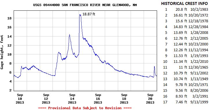
The San Francisco River at Glenwood crested at 18.87 feet (29,900 cfs) at 200am MDT September 15, 2013. This is the 2nd highest crest ever observed at this location and compares to a previous crest of 16.61 feet on October 20, 1972. The record crest is 20.8 feet set back on October 2, 1983. Major flooding was observed along many portions of the San Francisco all the way north to Reserve. Creeks and arroyos leading into this drainage system in the Apache Creek and Cruzville areas also reported flooding. Action stage is 12 feet, minor flood stage 15 feet, moderate flood stage 17 feet, and major flood stage 19 feet.
|
|
Photos
|
|
|
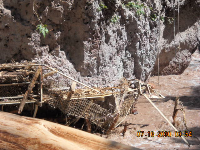
| The famous catwalk near Glenwood was destroyed by flooding. |
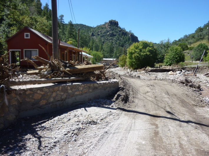 |
| Substantial damage occurred in the town of Mogollon and the road leading to it. |
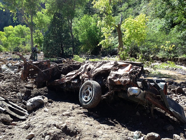 |
| Several vehicles were swept away by flood waters into Silver Creek near Mogollon. Image taken on September 19, 2013 a few days after flood waters had subsided. |