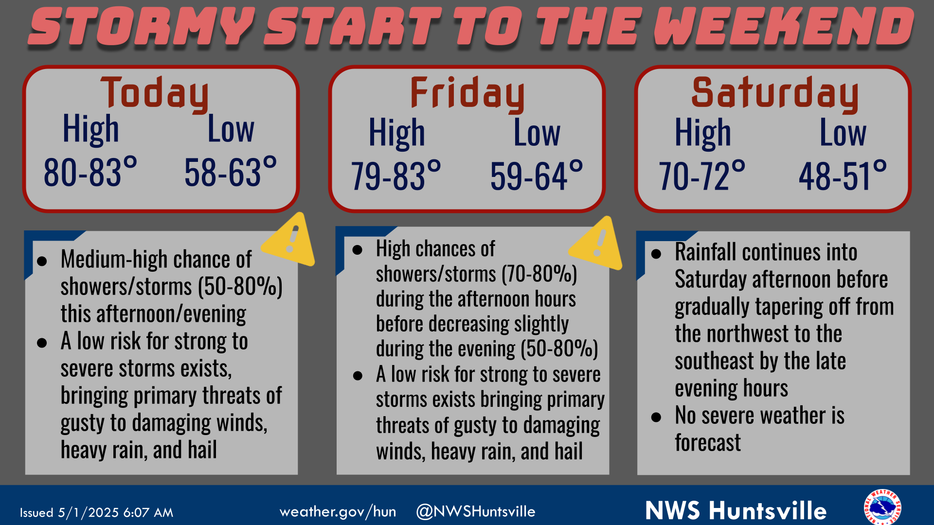
National Weather Service United States Department of Commerce
Click a location below for detailed forecast.

Last Map Update: Tue, Apr 29, 2025 at 10:50:23 am CDT

A return of moisture from the Gulf, along with higher instability from daytime heating, will bring low chances (20-30%) for showers and thunderstorms across parts of the Tennessee Valley this afternoon. Rain chances will increase as we go into the mid and latter portions of the week. Some of the thunderstorms Thursday into Friday could become strong to severe in intensity. A cold front is forecast to sweep across the area Friday, ushering drier and cooler air to the area for the upcoming weekend. High temperatures today into Thursday should warm into the low/mid 80s, then in the 70s Friday and Saturday. Lows in the 60s tonight through Thursday night will cool into the 40s and 50s Friday and Saturday nights.
High temperatures and precipitation chances for today.
Low temperatures and precipitation chances for tonight.
High temperatures and precipitation chances for tomorrow.
This graphic contains daily climate data (climate normals and records) for today for the sites listed. The legend is in the upper left portion of the image. The current normals period is 1991-2020.


Location Sky/Weather Temp Dewpt RH Wind Baro Remarks
Huntsville


Muscle Shoals


Decatur


Meridianville


Vinemont


Albertville


Scottsboro


Fort Payne


Winchester


Tullahoma


Fayetteville


Courtland


Note: "N/A" or "MISG" will be displayed if values are not available. In the LOCATION column, click on links for a list of recent observations at sites of interest. In the WIND column, VRB is "variable" and G is "gust". Wind speeds are in MPH. In the BARO (pressure) column, values are in inches. In the REMARKS column, HX is "heat index", WCI is "wind chill index", and VSB is "visibility" (if shown).
Text Product Selector (Selected product opens in a new window)
SITREP GRAPHICAL HWO DISCUSSION FIRE WX AVIATION WX HYDROLOGY
 
AIR QUALITY GRIDDED FORECAST FORECAST (HR) CLIMATE CLIMATE GRAPHS OBSERVATIONS
 
SATELLITE WX RADIOS   STORM SPOTTER TRAINING   PAST EVENTS GIS TORNADO HISTORY
Daily Climate for Middle Tennessee
EDUCATION BEING PREPARED ESTAR PREPARANDO