

Hot Topics
-
FY2022 NWS Office of Science and Technology Integration: Unified Forecast System Funding Opportunity
OSTI is soliciting research proposals that will advance the development of the community-based Unified Forecast System (UFS) through three competitions: 1) Next Generation Global Prediction System (NGGPS); 2) Weeks 3-4/S2S Program; and 3) Hurricane Forecast Improvement Program (HFIP). This notification (see announcement on grants.gov) is valued at approximately $3,000,000 for the first year of multi-year (2 or 3 year) projects. For more detailed descriptions, please click here.
-
STI-M is pleased to announce the FY2020 NWS Office of Science and Technology Integration: Unified Forecast System Funding Opportunity
OSTI is soliciting research proposals that will advance the development of the community-based Unified Forecast System (UFS) through three competitions: 1) Next Generation Global Prediction System (NGGPS); 2) Weeks 3-4 Program; and 3) Hurricane Forecast Improvement Program (HFIP). This notification is valued at approximately $2,800,000 for the first year of two-year projects. For more details to support NOAA’s development of the UFS, please click here.
-
Annotated outline of NOAA's draft Subseasonal and Seasonal (S2S) Forecasting report to Congress
The report will serve as a guidepost for NOAA planning and execution, as well as to inform the public and NOAA’s stakeholders on its efforts on subseasonal and seasonal (S2S) forecasting. The report will trace the continuum of effort for S2S, from current products and services to the innovations needed to enable and improve them.
Please see the S2S Report page here to review the annotated outline.
Weeks 3-4 Improving Mid-range Weather Outlooks Initiative
NOAA has initiated activities on a new initiative to extend weather forecasts out to the mid-range period in fiscal year 2016. This initiative, known as Weeks 3-4: Improving Mid-range Weather Outlooks supports activities at two NOAA line offices, the National Weather Service (NWS) and the Office of Oceanic and Atmospheric Research (OAR).
This is a five year initiative with activities planned in four major thrust areas: product innovation, extending numerical model guidance out in time, building a reforecast and reanalysis capability, and supporting applied research in the sub-seasonal forecast range. Funding provided by Congress will be applied over the five years between 2016 and 2020 to explore the potential for and to develop new products, advance NWS forecast skill, and to improve the usability of current and new experimental products for customers in collaboration with social scientists.

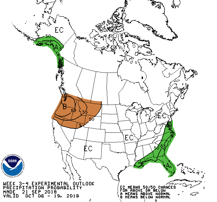
Figure 1. Current Week 3-4 Temperature Outlook (left) and experimental Precipitation Outlook (right) from CPC. Click to open larger image. For more information and a discussion of the current forecast click here to go to the CPC website.
To complement the Weeks 3-4 initiative, the OAR Climate Program Office Modeling, Analysis, Predictions, and Projections Program is partnering with NGGPS and other programs on new research and transition initiatives to advance sub-seasonal to seasonal forecasting. Nineteen multi-year projects led by scientists at NOAA, in other agencies, and at universities across the country are testing prediction systems for the NWS and exploring how to better model and predict storm tracks, persistent weather patterns, thunderstorm clusters in the Tropics, and other key sources of predictability in our Earth system that underpin a sub-seasonal to seasonal forecasting capability.
Work within this initiative targets extending products out in time as well as new outlook and forecast products. Product innovation will be achieved by applying advanced research techniques and development at the NWS Climate Prediction Center (CPC) and the Weather Prediction Center (WPC). These efforts involve enhancements and new development for forecast products in the mid-range period. In addition to these efforts, social scientists will work collaboratively with CPC and WPC to evaluate the understandability and effectiveness of these products for customers and partners. Feedback from stakeholders will enable the refinement of these new products and services.
Extending weather outlooks to the mid-range period is planned at the CPC. An example of the efforts at CPC is to extend a current capability now provided for week 2 out to the weeks 3 and 4 forecast period. Since September of 2015, the CPC has issued experimental graphical Weeks 3-4 Outlooks for probabilities of above or below normal temperature and precipitation as compared to climatological values for those periods. Figure 1 displays an example of the experimental Temperature and Precipitation Outlooks generated by the Climate Prediction Center (CPC) for Weeks 3-4. In the graphic on the left, the probability of below-normal temperatures is highlighted in blue and the probability of above-normal temperatures is shaded in orange. The graphic on the right depicts probabilities of above-normal precipitation in green, with below-normal probabilities in brown.
Other efforts planned by CPC beginning in late 2016 include projects that target improvements of some existing products and services as well as applied research for potential development of new outlook products related to the following areas:
- Enhance the Monthly Drought Outlook
- Develop Weeks 3-4 Excessive Heat Outlook
- Develop Weeks 3-4 Severe Weather Outlook
- Extend the Global Tropics Hazards and Benefits Outlook to Weeks 3-4
- Develop an Arctic Sea Ice Prediction Outlook for Weeks 3-4
The WPC plans to extend their existing products for temperature and precipitation outlooks from days 5-7 out to days 8-10. This effort will be conducted in collaboration with the CPC to enable sharing of best practices and work towards providing a more seamless suite of NWS products across the short term to mid-term forecast periods.
Extending the numerical modeling capabilities in support of the extension of products to the subseasonal time frame will be accomplished by providing guidance from the Global Ensemble Forecast System (GEFS) out to 35 days.
OAR developers are collaborating with the GEFS developers to establish the proposed techniques for the Reanalysis and Reforecast capabilities needed for diagnostics to support extending outlook products to the sub-seasonal time frame. Data access to previous reanalyses for selected numerical models are available at the Earth Systems Research Laboratory (ESRL) Reanalysis Projects.
Improved Arctic ice representation will be crucial for extending model fidelity to weeks 3-4, both in the Arctic and extratropical regions. NWS and OAR developers will join with other agency modelers and academic partners in a consortium for community management of the Los Alamos Sea Ice Model (CICE) to meet multiple user priorities. The CICE Consortium will coordinate community-developed ice model improvements, in the same paradigm to the efforts of the successful HYbrid Coordinate Ocean Model (HyCOM) Consortium, which is also crucial to extending atmosphere model fidelity.
OAR developers funded as a part of this initiative are investigating blocking related processes in existing numerical models to identify potential causes. This project will also support research and development to identify efforts most needed to improve the forecast skill at weeks 3-4.
A comprehensive Weeks 3-4 plan describing the details for the FY 2016 to 2020 time frame is under development and will be made available from this link in the near future. Please check back soon.