
Highlights of Severe Weather Preparedness Week include:
Daily severe weather topics, preparedness tips, and safety messages
 NWS Springfield will issue a test tornado warning as part of the drill. Local warning sirens, NOAA All-Hazards Weather Radio, and the Emergency Alert System (EAS) will be activated to signal the start of the drill. The "TOR" code for EAS and NOAA Weather Radio will be used again this year to simulate what would occur in the event of an actual tornado warning.
Residents should treat the drill as if it were an actual tornado warning. The purpose of the drill is to test everyone's readiness for life-threatening severe weather events such as tornadoes, flash floods, and damaging winds. Local officials may sound warning sirens to initiate the drill.
|
The Weather Ready Nation is about building community resilence in the face of increasing vulnerability from extreme weather events. Recent tornadoes, floods, drought, etc. demontrate the need to be prepared. Are you weather ready? Here are resources to help you be prepared before disaster strikes. NWS Severe Storm Safety | Missouri Storm Aware | Kansas Awareness Info | Ready.gov | SEMA
|
|
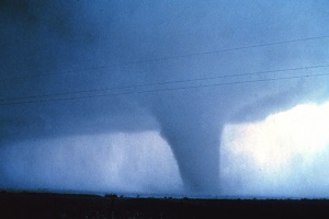
Deadly and devastating tornadoes have demonstrated their awful power in Missouri and Kansas. Now is the time to develop a tornado safety plan before a tornado strikes. Knowing what to do before a tornado occurs is essential to protect lives. |
|
 |
Severe thunderstorms produce a variety of weather hazards including tornadoes, large hail, damaging straight line winds, flooding, and lightning. Now is the time to review Severe Weather Safety Information. Severe thunderstorms producing damaging winds in excess of 60 mph and large hail can be a threat to life and property. Damaging straight line winds are much more common than tornadoes and can be just as deadly. Those caught outdoors during a severe thunderstorm are particularly vulnerable. Boaters and campers should be especially alert to the potential of severe storms. High winds associated with severe thunderstorms can strike suddenly. Winds in excess of 60 mph can easily capsize boats and put campers at risk due to falling trees. |
|
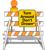
Typically, flooding results in more weather related fatalities than any other thunderstorm related hazard. Why? Because many of the deaths occur in automobiles when driven through flooded roads as they are swept downstream. Of these drownings, many are preventable, but too many people continue to drive across a flooded road. For more information, go to the Flood Safety page. One of the primary flood hazards and causes of flood related deaths is driving into and through low water crossings. Every year, a few adventurous drivers attempt to cross flooded roads and fail. Learn more about Low Water Crossings |
|


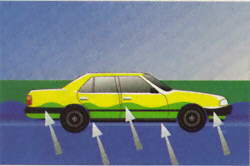
Water weighs 62.4 lbs. per cubic foot and typically flows downstream at 6 to 12 mph. When a vehicle stalls in the water, the water’s momentum is transferred to the car. For each foot the water rises, 500 lbs. of lateral force is applied to the automobile.
But the biggest factor is bouyancy. For each foot the water rises up the side of the car, the car displaces 1500 lbs. of water. In effect, the automobile weighs 1500 lbs. less for each foot the water rises. Two feet of water will carry away most automobiles!
At any given moment, there are 1,800 thunderstorms in progress somewhere on Earth. This amounts to 16 million storms a year! In the United States, there are an estimated 25 million cloud-to-ground lightning flashes each year. While lightning can be fascinating to watch, it is also extremely dangerous.
Tragedies in school-sponsored athletics are unfortunately a growing trend as well. When thunderstorms threaten, coaches and officials must not let the desire to start or finish an athletic activity or event cloud their judgment when the safety of participants and spectators is in jeopardy.
For more lightning facts and safety information, go to the NWS Lightning Awareness page.
Did you know that your National Weather Service office in Springfield, Missouri offers a wealth of information to alert you of potential or imminent severe weather and flooding? Below is a list of severe weather products, as well the product descriptions and intended response.
Severe Weather Decision Support Briefing Page
Enhanced Hazardous Weather Outlook
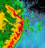
Springfield Radar
Weather Ready Preparedness Page
|
Severe Weather Warnings and Outlooks
|
||
|
Product
|
Description
|
Awareness & Action Level
|
| Hazardous Weather Outlook | Issued at least twice daily by 6 AM and 4 PM to alert you of potential weather hazards. | Stay tuned to later statements and be alert for the development of hazardous weather. |
| Severe Weather Watches | Issued when conditions become favorable for the development of severe weather. | Prepare and take necessary precautions in the event a warning is issued or severe weather is observed. |
| Severe Thunderstorm Warning | Issued when severe weather (1" hail or larger and/or winds in excess of 58 mph) is imminent. | Take immediate action to save lives and property. |
| Tornado Warning | Issued when a tornado is imminent and has been spotted or indicated by doppler radar. | Take immediate action to save lives and property. |
| Severe Weather Statement | Issued to update the status of severe weather warnings and give specific details on the location and severity of storms. | |
| Local Storm Reports | Issued to inform you of actual severe weather occurrences. | |
| Flooding | ||
|
Product
|
Description | Awareness & Action Level |
| Flood Watch | Issued when conditions become favorable for flooding. | Prepare and take necessary precautions in the event a warning is issued or flooding is observed. |
| Flash Flood Warning | Issued when rapid and life-threatening water rises are imminent. | Take immediate action to save lives and property. |
| Flood Warning | Issued for main stem river flooding or over land flooding for an extended period of time. | Take immediate action to save lives and property. |
| Flash Flood & Flood Statements |
Issued to update the status of warnings and watches, and give specific details on the locations and severity of flooding. |
|
NWS Springfield covers the Missouri Ozarks and portions of southeast Kansas. We are surrounded by eight other National Weather Service offices. We issue watches and warnings for the protection of life and property. You can help us with your reports of severe weather and staying connected on social media. For additional information, visitt your local NWS office website and social media pages:
|
417-863-8028
|
636-441-8467
|
816-540-6132
|
785-234-2592
|
316-942-3102
|
918-838-7838
|
501-834-0308
|
901-544-0399
|
270-744-6440
|


 Weather Story
 Weather Map
 Local Radar