
High winds and very dry conditions will bring extremely critical fire weather over a large part of New Mexico today. Red Flag and High Wind Warnings have been issued. Isolated to scattered severe thunderstorms may produce large to very large hail and localized damaging winds late this afternoon into evening from the eastern Central Plains to the Upper Midwest. Read More >
Links | Map | Warnings, Radar, & Satellite | Fire & Thunder Forecasts
| Fuels and Fire Danger Maps
 |
 |
 |
|
Click Image To Enlarge This image shows the expected peak wind gusts over the next 12 hours. |
Click Image To Enlarge This image shows the expected peak wind gusts over the 12 hour period ending at the time stated in the header.
|
 |
 |
|
Click Image To Enlarge This image shows the expected peak wind gusts over the 12 hour period ending at the time stated in the header.
|
Click Image To Enlarge This image shows the expected peak wind gusts over the 12 hour period ending at the time stated in the header.
|
 |
 |
|
Click Image To Enlarge This image shows the expected minimum relative humidity today.
|
Click Image To Enlarge This image shows the expected minimum relative humidity tomorrow. |
Current Warnings, Radar, and Satellite- Click to Enlarge
 |
 |
|
|
Click Image to Enlarge Teton Pass, looking East |
|
|
|
|
|
 |
 |
 |
|
|
|
Storm Prediction Center Critical Fire Areas and Thunderstorm Forecasts - Click to Enlarge
|
|
|
|
 |
 |
 |
|
|
|
|
 |
 |
 |
|
|
|
|
 |
 |
 |
|
|
|
|
|
|

|

|

|

|

|
|
|
|
|
|
|
 |

|
 |
 |
 |
|
|
|
|
|
|
 |

|
 |
 |
 |
USFS Fire Danger Graphics and Fuels - Click to Enlarge
|
|
|
|
 |
 |
 |
|
|
|
|
|
 |
 |
 |
 |
|
|
|
|
|
 |
 |
 |
 |
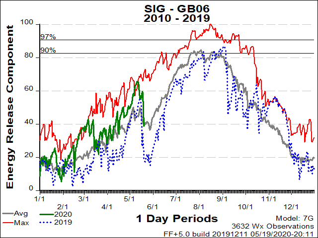
| BT National Forest ERC Fuels Graph |
|
|
 |
 |
 |
Return to NWS Riverton Homepage
 |
Building a Weather-Ready Nation |


.png)


