
A Pacific storm and atmospheric river will impact the Pacific Northwest states and northern Rockies this weekend, bringing locally heavy low elevations rain and heavy high elevation snow in the mountains. By Sunday over the Interior Northwest, rain combined with snowmelt will increase the risk of flood hazards. Flood Watches are in effect. Read More >
 |
Building a Weather-Ready Nation |
Summary | Travel Center | Forecast | Monitoring & Reporting | Safety
SYNOPSIS: A large storm system continues to track east, which will make a significant impact on our weather tonight.
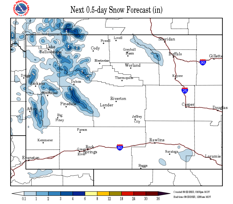
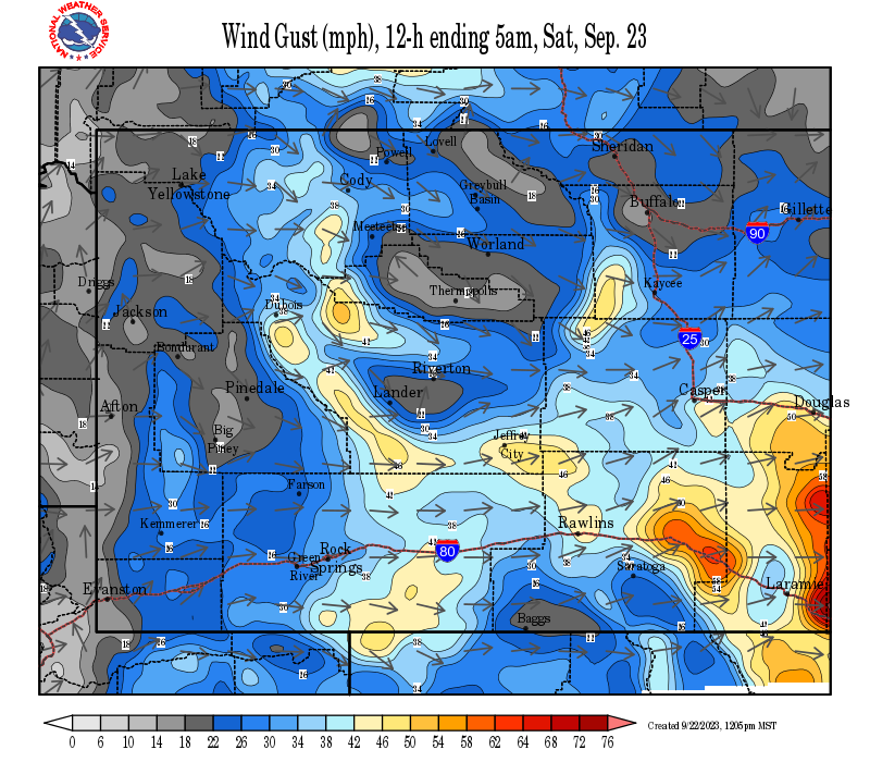
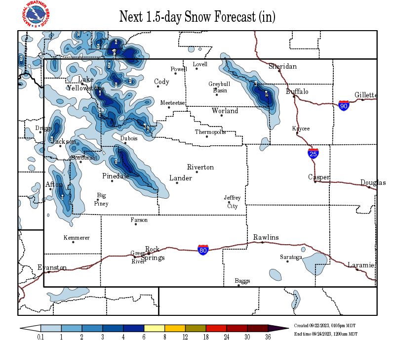
Accumulating snowfall will occur over much of Wyoming with the heaviest snowfall expected along and east of the Divide this evening. The winds will continue to be elevated behind the front with considerable blowing and drifting snow expected, especially at pass level with near whiteout conditions possible at times.
 |
|
Click Image To Enlarge Storm Impact Index |
IMPACTS: For anyone traveling, expect snow and wind to create slick roads and difficult driving conditions at times, especially at pass level. Rapidly accumulating snow could produce slushy roads and slow travel along portions of Interstates 80, 90, and 25.
Those with outdoor interests should also be prepared for much colder, wet, and windy conditions.
The low wind chills, gusty winds, and cold, wet conditions will also have an impact on newborn livestock through tonight. In addition, a hard freeze could damage sensitive newly budded vegetation overnight tonight.
 |
 |
|
Click Image To Enlarge Pink Shades = Winter Storm Warning Purple Shades = Winter Weather Advisory |
Click Image To Enlarge
|
Travel is expected to be adversely impacted with Interstate delays or closures possible, several passes and side roads could also see extended times of difficult travel and/or closures as well.
|
|
|
|
|
|
|
|
 |
 |
 |
 |
|
|
|
|
|
 |
 |
 |
 |
|
|
|
|
|
|
|
 |
 |
 |
If you plan to travel, we recommend checking road conditions along your route and staying on top of road closures here. If you are on Twitter, follow the hashtag: #WyoRoad (or look below) for the latest weather affecting roads and road conditions in and around Wyoming.
| Tweets by @NWSRiverton | #WyoRoad Tweets |
|
Get the play-by-play on this storm and contribute your own snow reports to #wywx |
On the road? Tweet road conditions to #WyoRoad!
|
Stay up to date with our current products, and what they mean as they will be updated throughout the storm:
|
|
|
|
|
|
|
|
Wind Watch / Warning |
|
Latest Multimedia Briefing |
|
|
 |
 |
|
Click Image To Enlarge 12 Hour Snow Accumulation Forecast |
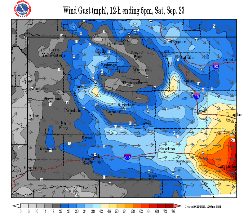
Click Image To Enlarge 12 Hour Peak Wind Gusts |
 |
 |
|
Click Image To Enlarge 24 Hour Snow Accumulation Forecast |
Click Image To Enlarge 24 Hour Peak Wind Gusts |
 |
 |
|
Click Image To Enlarge 36 Hour Snow Accumulation Forecast |
Click Image To Enlarge 36 Hour Peak Wind Gusts |

PLEASE SEND US YOUR SNOW REPORTS (CLICK HERE)
 |
Monitor our Severe Weather Summary Page for current Warnings, Watches, and Advisories. What's the difference? |
 |
Check the latest Weather Story graphic for an overview of the area forecast. |
 |
Check out what's on the radar. Riverton | Pocatello | Cheyenne | Billings | Salt Lake City | Rapid City | Mosaic |
 |
Submit storm reports/images and keep up to date with us on Facebook! |
 |
Submit storm reports/images and keep up to date with us on Twitter! |
 |
Other reporting methods include eSpotter, email (cr.wxriw@noaa.gov), or by phone at 1-800-211-1448. |
 |
Check the latest Public Information Statement for the latest storm reports. |
 |
Monitor current road conditions by visiting the Wyoming Dept. of Transportation (WYDOT) or by calling 5-1-1. |
Winter Safety Kit | Winter Weather Safety
 |
Learn more about the National Weather Service's efforts to build a Weather-Ready Nation! |