North Carolina Hurricane Preparedness Week May 4th - May 10th
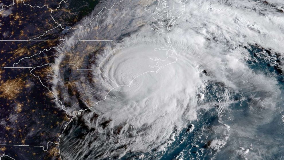
Hurricane Florence Makes Landfall In 2018
National Hurricane Preparedness Week is May 4th - May 10th, 2025. The National Weather Service and the North Carolina Department of Public Safety are teaming up to bring this hurricane safety campaign to all of North Carolina’s residents. With warmer weather quickly approaching, now is the time to prepare for hurricane season. If each North Carolina resident would take a few moments this week to learn about hurricane safety and implement a hurricane safety plan, then we would all be better off when hurricanes threaten our area. Remember you should prepare EACH and EVERY YEAR, as it only takes ONE Storm!
Please join us in promoting hurricane preparedness during this year's "Hurricane Preparedness Week". The National Weather Service asks emergency management, public safety officials, local media and Weather-Ready Nation Ambassadors to help join forces in improving the nation's readiness, responsiveness, and overall resilience against hurricanes during the upcoming season.
| Day of The Week | Topics |
|---|---|
| Sunday | Know Your Risk: Water & Wind |
| Monday | Prepare Before Hurricane Season/Know Your Zone/Storm Surge |
| Tuesday | Understand Forecast Information/High Winds |
| Wednesday | Get Moving When a Storm Threatens/Inland Flooding |
| Thursday | Stay Protected During Storms/Tornadoes |
| Friday | Use Caution After Storms/Rip Currents |
| Saturday | Take Action Today |
Click on the tabs below for more hurricane preparedness information.
Sunday
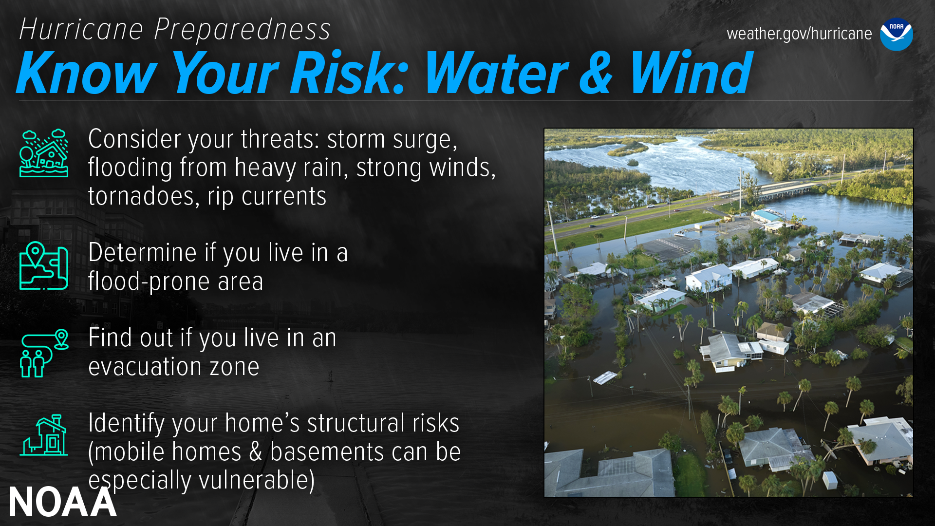
Know Your Risk: Water & Wind
Audio PSA of the day (~ 30 seconds)
Know Your Risk Where You Live
Find out today what types of wind and water hazards could happen where you live. Hurricanes are not just a coastal problem. Impacts from wind and water can be felt hundreds of miles inland, and significant impacts can occur regardless of the storm’s strength. Know if you live in an area prone to flooding, if you live in an evacuation zone, and identify any structural weaknesses in your home.
Consider Your Threats
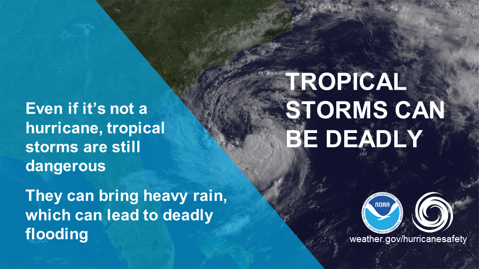
While hurricanes pose the greatest threat to life and property, tropical storms and tropical depressions also can be devastating. The primary hazards from tropical cyclones (which include tropical depressions, tropical storms, and hurricanes) are storm surge flooding, inland flooding from heavy rains, destructive winds, tornadoes, and high surf and rip currents.
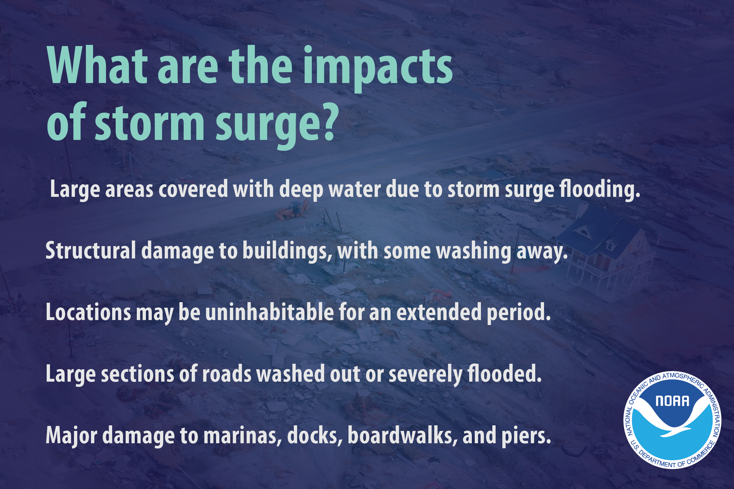
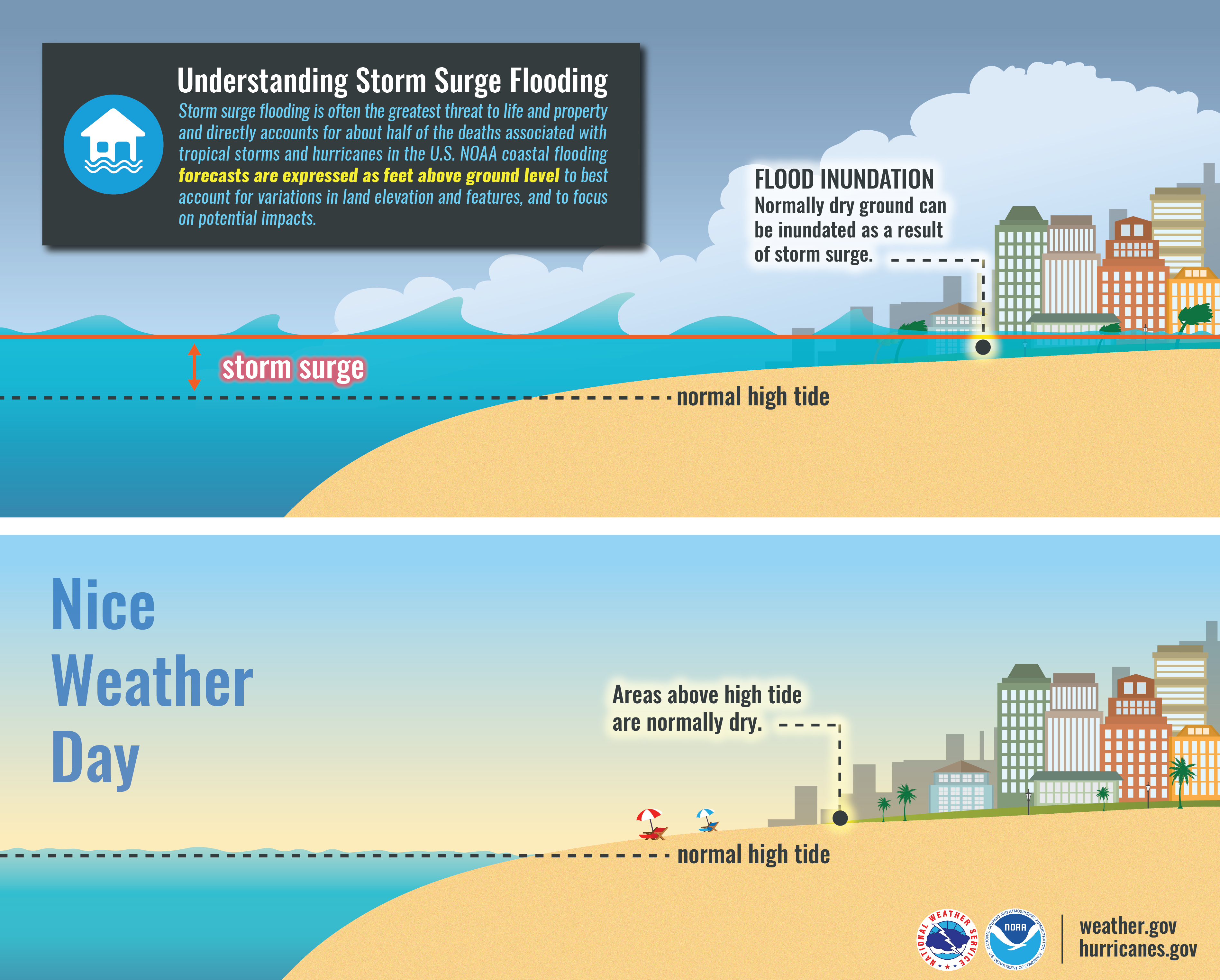
Storm surge is water that is pushed toward the shore by winds swirling around the storm, and historically has caused the largest loss of life in hurricanes. This rise in water level can cause severe flooding in coastal areas, which can submerge entire areas, cause structural damage to buildings, and wash out roads. Storm surge can travel several miles inland, especially along bays, rivers, and estuaries.
Flooding from the extreme amounts of rain a hurricane can bring has also proven to be very deadly, both over an extended period of time as well as very short-term flash flooding. Homes and businesses could flood, and flooded roads could make travel and evacuations difficult, as well as being a potentially deadly hazard to those in vehicles or on foot. Floodwaters can also contain harmful bacteria, chemicals, wildlife and other dangerous objects. Extreme rain from hurricanes can even flood areas that aren’t normally prone to flooding. Flooding can happen hundreds of miles inland, and can persist for several days after a storm.
Hurricane-force winds can cause damage to homes and other buildings, ranging from moderate to catastrophic depending on both wind speed and structural integrity. Wind damage can lead to large areas with power and communications outages, as well as uproot trees and make roads impassable due to debris. Signs, roofing material, and other items left outside can become flying missiles during hurricanes. Mobile homes are especially vulnerable to wind damage.
Hurricanes and tropical storms can also produce tornadoes. These tornadoes most often occur in thunderstorms embedded in rain bands well away from the center of the hurricane; however, they can also occur near the eyewall.
Waves from distant storms can produce deadly rip currents and rough surf on beaches very far away. Good weather at the beach itself does NOT mean the ocean is safe. Even storms more than 1,000 miles away can cause impacts.
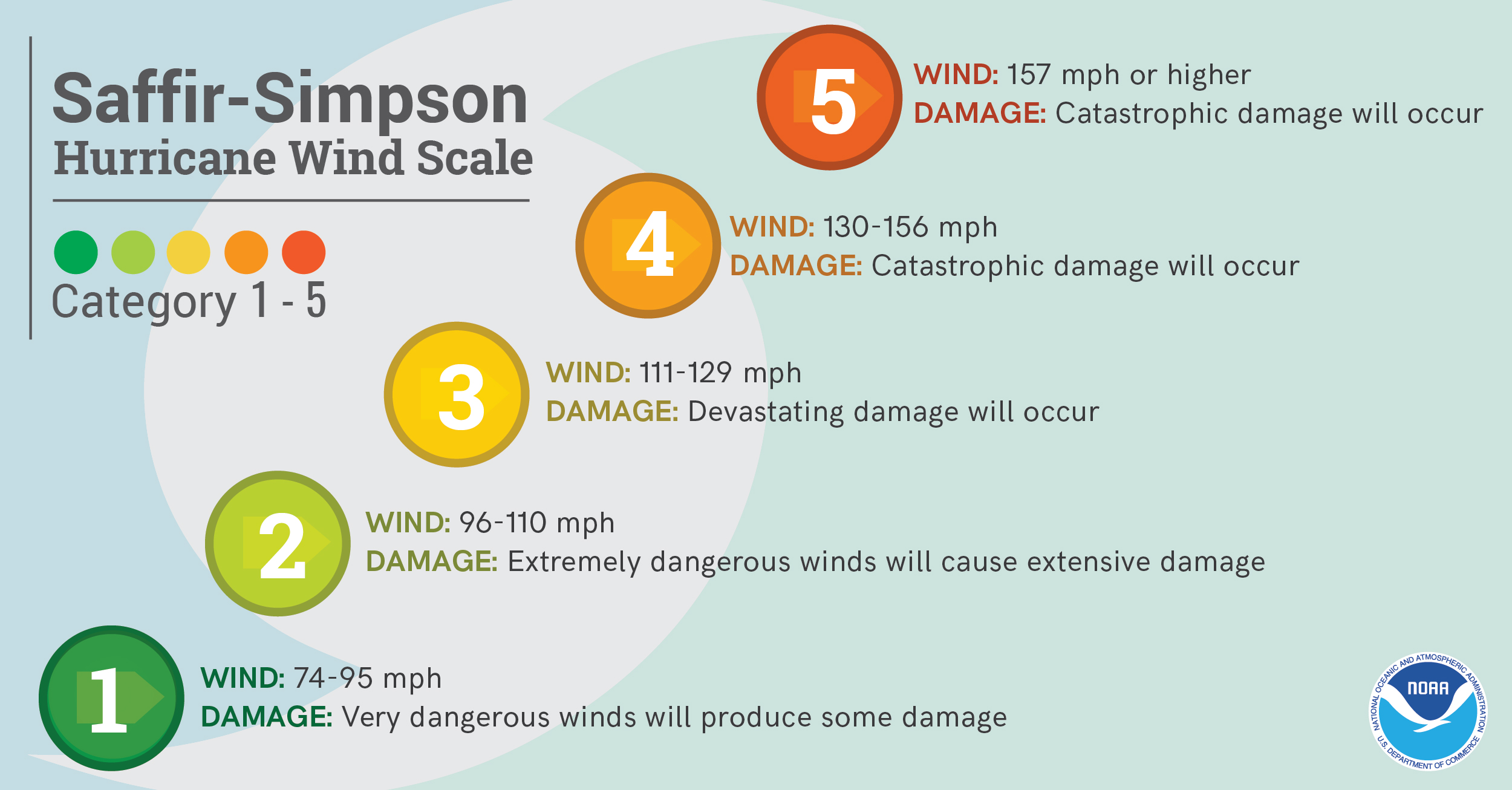
Why Should I Not Focus On The Category Alone?
The Saffir-Simpson Scale is a wind scale that uses WIND only to estimate potential damage. Unfortunately this scale does not tell you about ALL of the impacts that a hurricane can produce. It does not tell you how much rain will fall or how high the storm surge may be. It does not tell you anything about potential impacts from tornadoes or rip currents. It also does not give you information on how large the storm may be, or anything about the storm's movement. In fact, water accounts for 90% of direct deaths from tropical systems, both from storm surge and flooding rain. Please keep this in mind this upcoming season. Pay attention TO ALL of the impacts from a storm and not just the category. Remember that Hurricane Florence was "just" a category 1 when it made landfall along our coast.
Determine if you live in a flood-prone area
Anyone living in a flood-prone area is especially vulnerable to hurricane impacts. Find out today the flood risk for your area and plan accordingly. If you don’t live in a flood zone, that doesn’t necessarily mean you’re safe - extreme rain from hurricanes can bring floods even to areas that aren’t prone to flooding.
Find out if you live in an evacuation zone
Determine if you live in a storm surge evacuation zone. This can tell you about your vulnerability to storm surge, and will be imperative when it comes time to develop an evacuation plan.
HurricaneStrong: Find Your Evacuation Zoneoffsite link
Know Your Zone NC: Learn Established Evacuation Zones For Eastern North Carolina
Identify your home’s structural risks
Find out if your home has any weaknesses that could prove deadly in a hurricane. Are your exterior doors and garage door hurricane proof? Do you have storm shutters? Some aspects of your home can be strengthened to help withstand hurricane impacts, and some can not. Mobile homes are especially vulnerable to hurricane-force winds, and basements are especially vulnerable to storm surge and flooding.
When Is Hurricane Season?
The most active months for tropical systems in North Carolina are August, September and October. However, hurricanes have impacted our state as early as May and as late as November! The peak tropical activity usually occurs in a six week period from mid-August to late September, during which time our state can experience multiple hurricanes or tropical storms within weeks of each other.
Additional Resources:
View Video For More
​
Monday
Prepare Before Hurricane Season
Audio PSA of the day (~ 60 seconds)
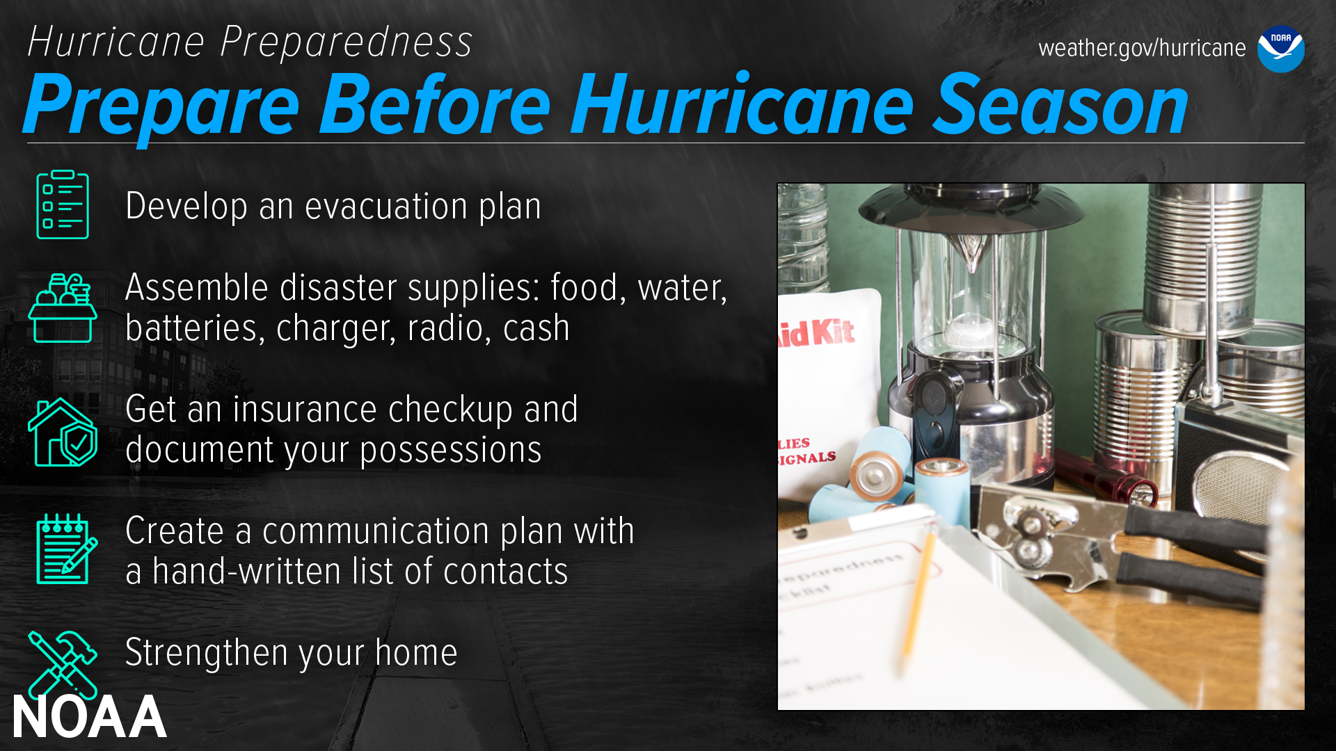
The best time to prepare is before hurricane season begins. Avoid having to rush through potentially life-saving preparations by waiting until it’s too late. Get your disaster supplies while the shelves are still stocked, and get that insurance checkup early, as flood insurance requires a 30-day waiting period.
Develop an evacuation plan
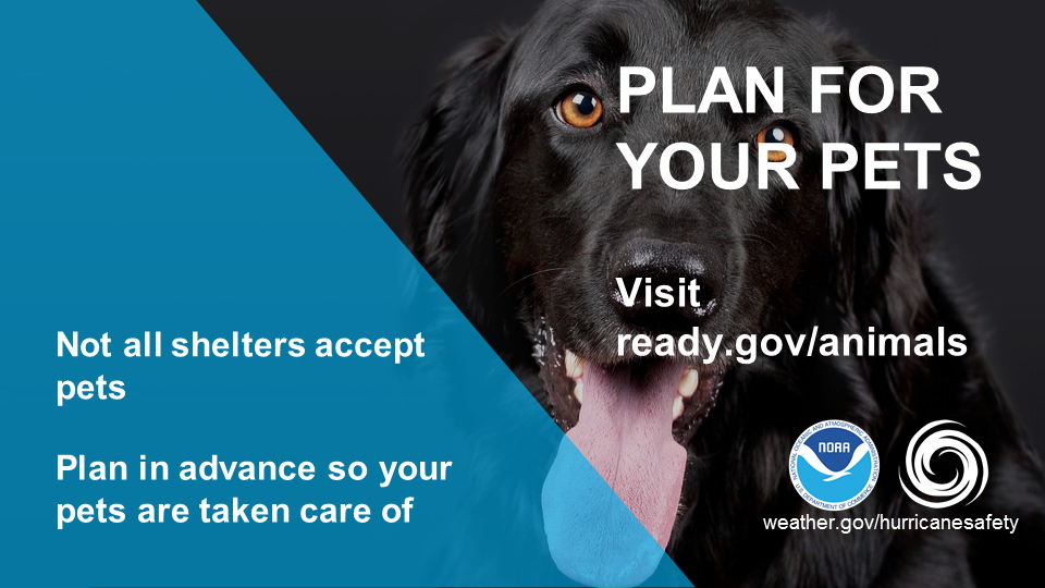
If you are at risk from hurricane impacts, you need an evacuation plan. Now is the time to begin planning where you would go and how you would get there. You do not need to travel hundreds of miles. Your destination could be a friend or relative who lives in a well built home outside flood prone areas. Plan several routes. Be sure to account for your pets.
If you don’t have a vehicle, check with local officials to see what transportation options they may have available.
Assemble disaster supplies
Whether you’re evacuating or sheltering-in-place, you’re going to need supplies not just to get through the storm but for the potentially lengthy and unpleasant aftermath. Have enough non-perishable food, water and medicine to last each person in your family a minimum of 3 days (store a longer than 3-day supply of water, if possible). Electricity and water could be out for weeks. You’ll need extra cash, a battery-powered radio and flashlights. You may need a portable crank or solar-powered USB charger for your cell phones. And lastly, don’t forget your pets!
Get an insurance checkup & document your possessions
Call your insurance company or agent and ask for an insurance check-up to make sure you have enough insurance to repair or even replace your home and/or belongings. Remember, home and renters insurance doesn’t cover flooding, so you’ll need a separate policy for it. Flood insurance is available through your company, agent, or the National Flood Insurance Program at floodsmart.gov. Act now, as flood insurance requires a 30-day waiting period.
Take the time before hurricane season begins to document your possessions: photos, serial numbers, or anything else that you may need to provide your insurance company when filing a claim.
FLASH Insurance Guide: If Disaster Strikes, Will You Be Covered? offsite link
Find flood insurance at floodsmart.gov
Create a communication plan
Take the time now to write down your hurricane plan, and share it with your family. Determine family meeting places, and make sure to include an out-of-town location in case of evacuation. Write down on paper a list of emergency contacts, and make sure to include utilities and other critical services — remember, the internet may not be accessible during or after a storm.
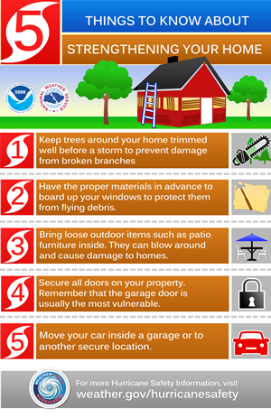
Strengthen Your Home
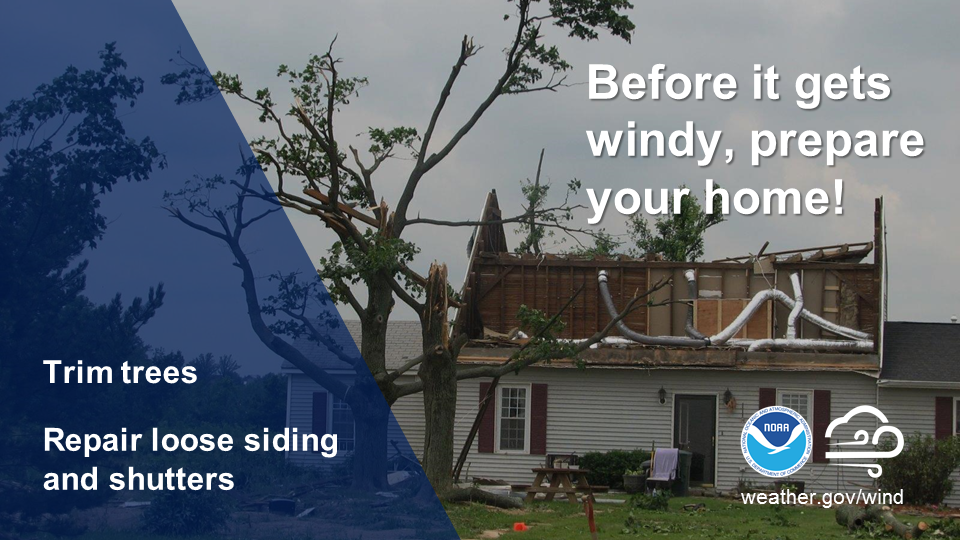
Now is the time to improve your home’s ability to withstand hurricane impacts. Trim trees. Install storm shutters, accordion shutters, and/or impact glass. Seal outside wall openings. Remember, the garage door is the most vulnerable part of the home, so it must be able to withstand hurricane-force winds. Many retrofits are not as costly or time consuming as you may think. If you’re a renter, work with your landlord now to prepare for a storm.
And remember - now is the time to purchase the proper plywood, steel or aluminum panels to have on hand if you need to board up the windows and doors ahead of an approaching storm.
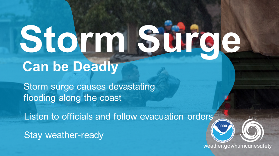
Storm Surge
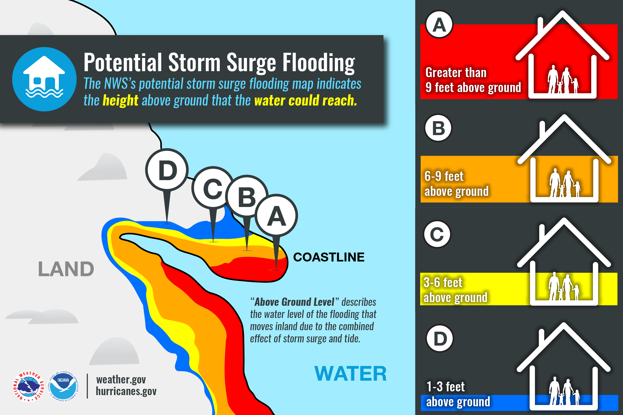
One of the greatest potentials for loss of life related to a hurricane is from the storm surge. Storm surge is simply water that is pushed toward the shore by the force of winds swirling around the storm. This advancing surge combines with the normal tides to create the hurricane storm tide, which can increase the mean water level to heights impacting roads, homes and other critical infrastructure. The shape and orientation of our coastline put's us at risk for storm surge. Most recently we saw devastating storm surge from both hurricanes Florence and Dorian.
Know Your Zone
Know Your Zone is a cooperative effort of North Carolina Emergency Management and county emergency management partners in coastal counties. After being piloted during the 2019 hurricane season, state and county emergency emergency management will partner to officially launch the Know Your Zone initiative prior to the peak of the 2020 season.
North Carolina Know Your Zone is a tiered evacuation system that highlights areas most vulnerable to impacts from hurricanes, tropical storms, and other hazards. If it becomes necessary, local officials will order evacuations using pre-determined zones created by coastal counties. The Know Your Zone lookup tool is a new color-coded interactive map you can use to determine the evacuation zone where you live, work, or are visiting based upon your street address.
Evacuation zones highlight areas most at risk to storm surge and flooding. Local officials will determine which areas should be evacuated. Areas in Zone A will typically be evacuated first, followed by areas in Zone B, etc. While all zones won’t be evacuated in every event, emergency managers will work with local media and use other outreach tools to notify residents and visitors of impacted zones and evacuation instructions.
Please take some time this week to read more about Know Your Zone in preparation for this launch and coming hurricane season. To access the lookup tool and other resources, please visit the website by clicking on the image below.

Storm Surge Infographics
 |
 |
 |
 |
 |
 |
View Video For More
Tuesday
Understand Forecast Information
Audio PSA of the day (~ 60 seconds)
National Weather Service forecast products can tell you a lot about what is expected to happen with a storm, including the storm’s paths, rainfall amounts, wind speeds, and more. There is a lot of information available days ahead of a storm, and it is important to understand what it means.
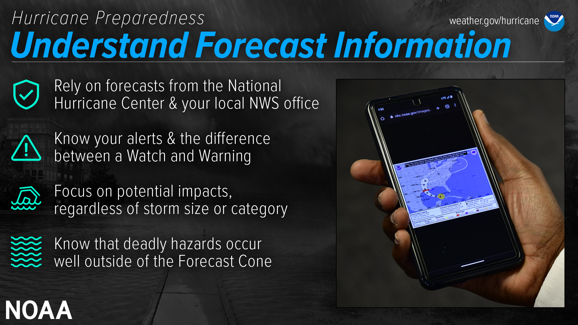
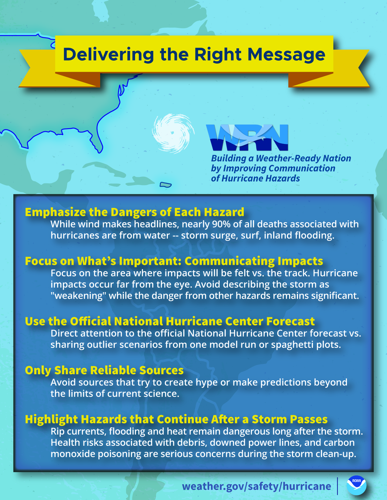
Have trusted sources for storm information
Rely on official forecasts and well-established media partners in the Weather Enterprise. Be cautious of sensational headlines and instead look for reliable sources to determine a storm's potential impacts.
Use the official National Hurricane Center Forecast — their hurricane specialists access a variety of data (models, aircraft, satellite) to make the most accurate forecasts possible. Meteorologists at local NWS offices understand which locations in your area are most vulnerable to storm surge, flooding, and wind.
Always check to make sure you have the latest forecast information.
Make sure to have Wireless Emergency Alerts enabled on your phone to receive Warnings.
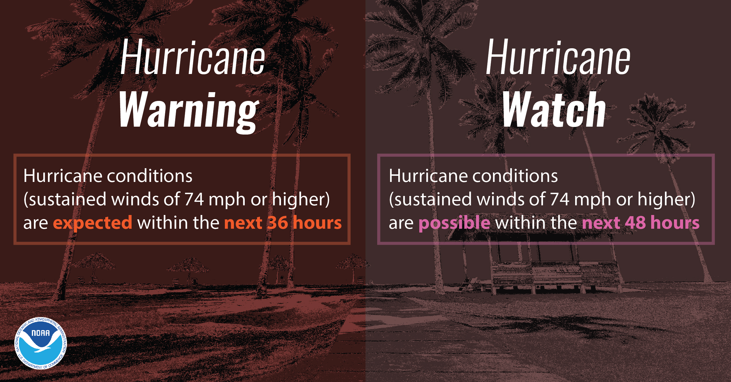
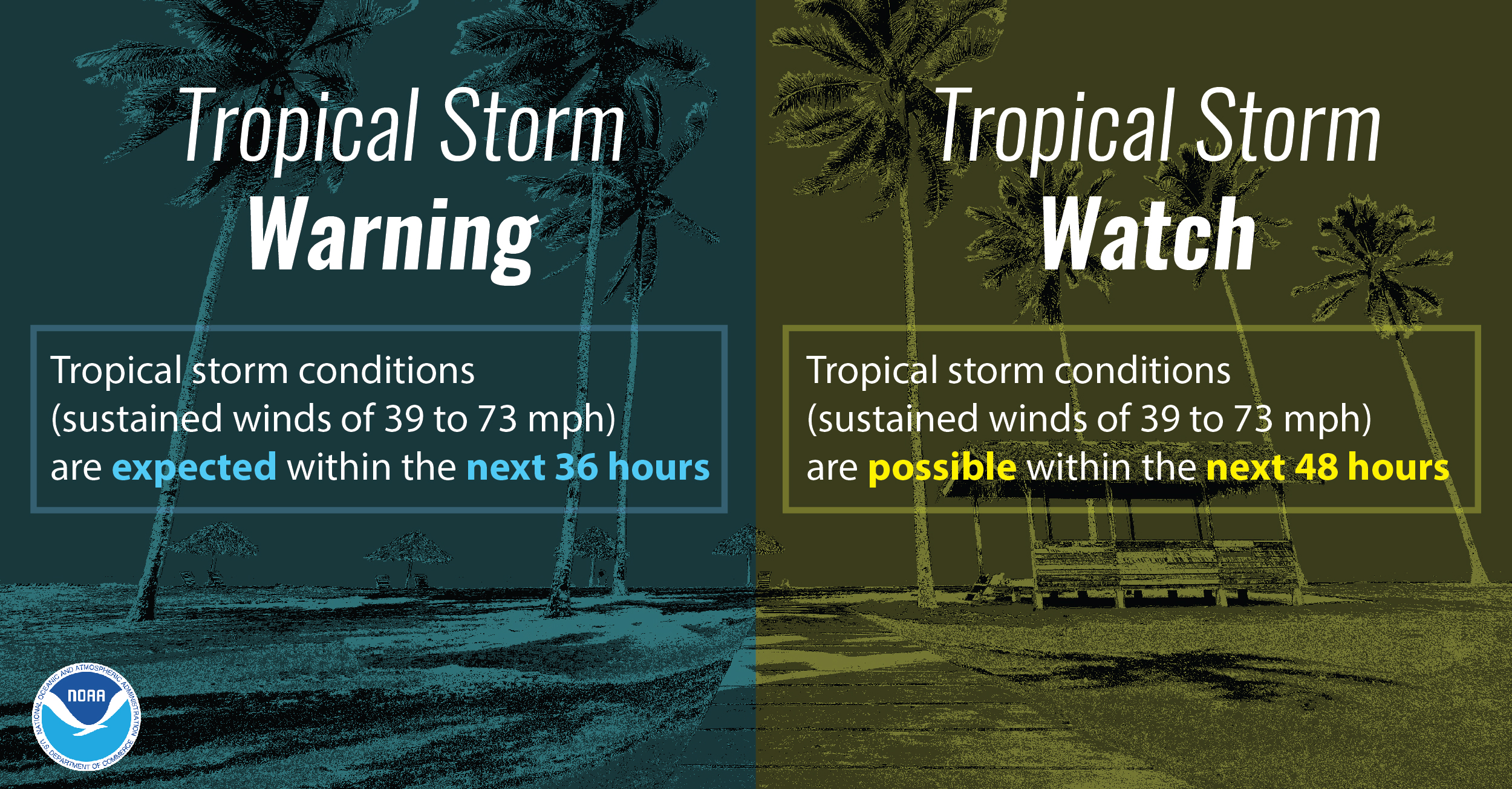
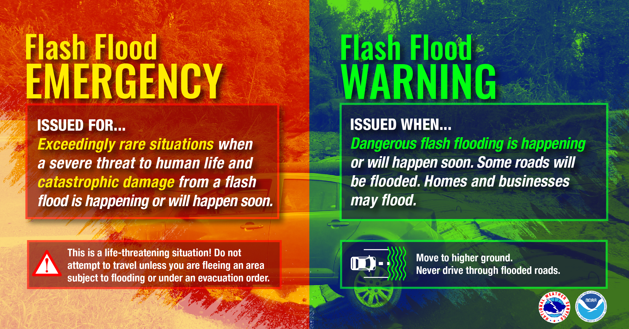
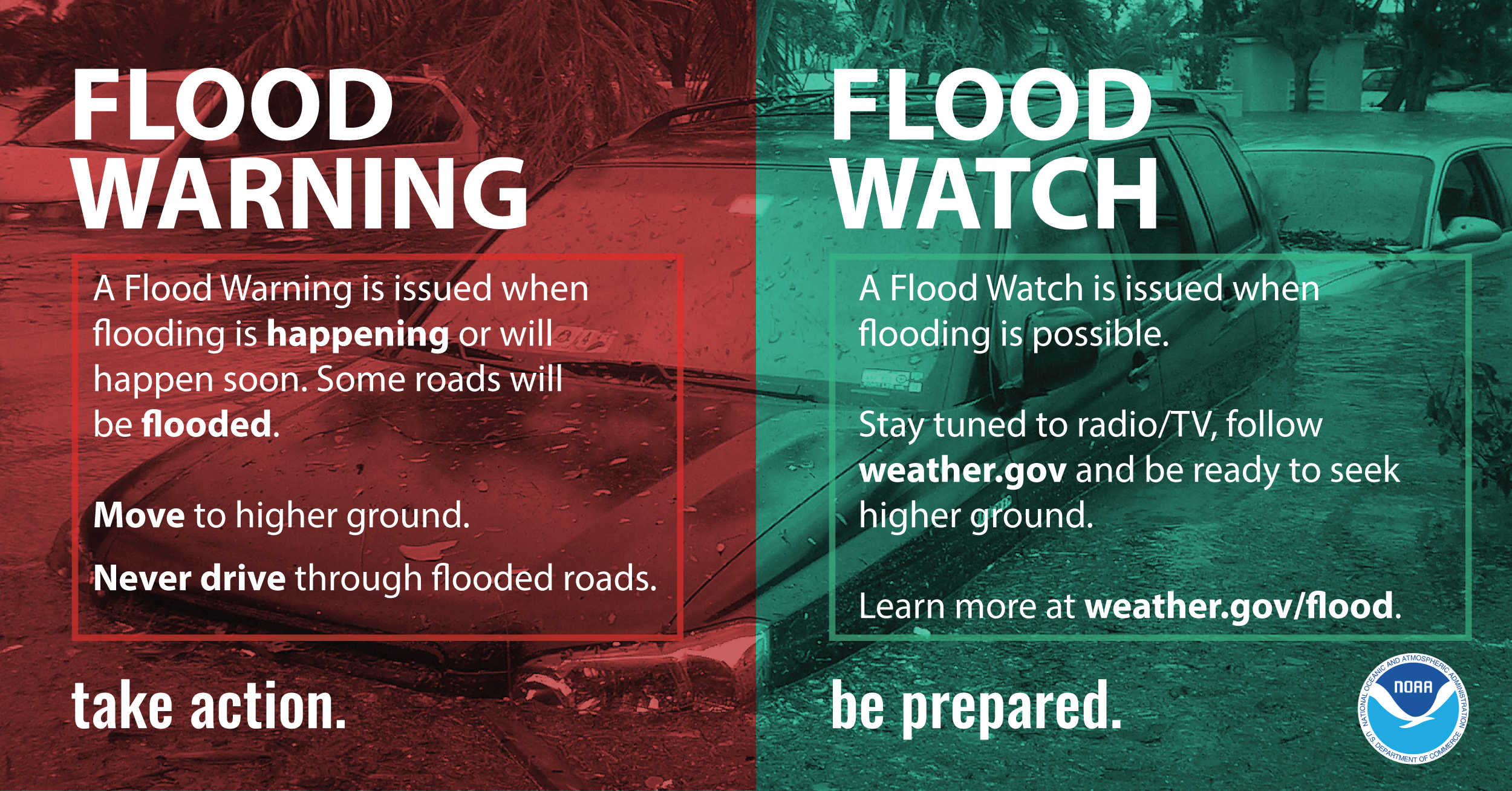
Know your alerts & the difference between a Watch & Warning
In general, a Watch means impacts are possible; a Warning means impacts are expected or happening. Different hazards and alerts require different responses:
Focus on potential impacts regardless of storm size or category
Do not focus on a specific storm category; all hurricanes and tropical storms can bring life-threatening storm surge, inland flooding, and damaging winds. The storm's scale only tells you about the strongest winds near the center of the storm and does not tell you about potentially life-threatening flooding from storm surge or rain. Remain vigilant even if the winds have weakened and the storm becomes a lower category or tropical storm — rainfall and storm surge impacts often continue.
Hurricane Information Infographics
 |
 |
 |
|
 |
|
Deadly hazards occur well outside of the cone
Impacts can be felt far from the storm's center, even well inland and outside the Forecast Cone. Remember: the storm itself can stretch well beyond the Forecast Cone, and so can the impacts.
The National Hurricane Center Forecast Cone shows the probable forecast track of the center of the storm. This means that the storm’s center will probably travel somewhere within the cone’s boundaries. (Historically, the storm’s center has remained within the forecasted cone roughly two-thirds of the time.) The cone does NOT represent the size of the storm in any way.
NHC Video: How to use the cone graphic
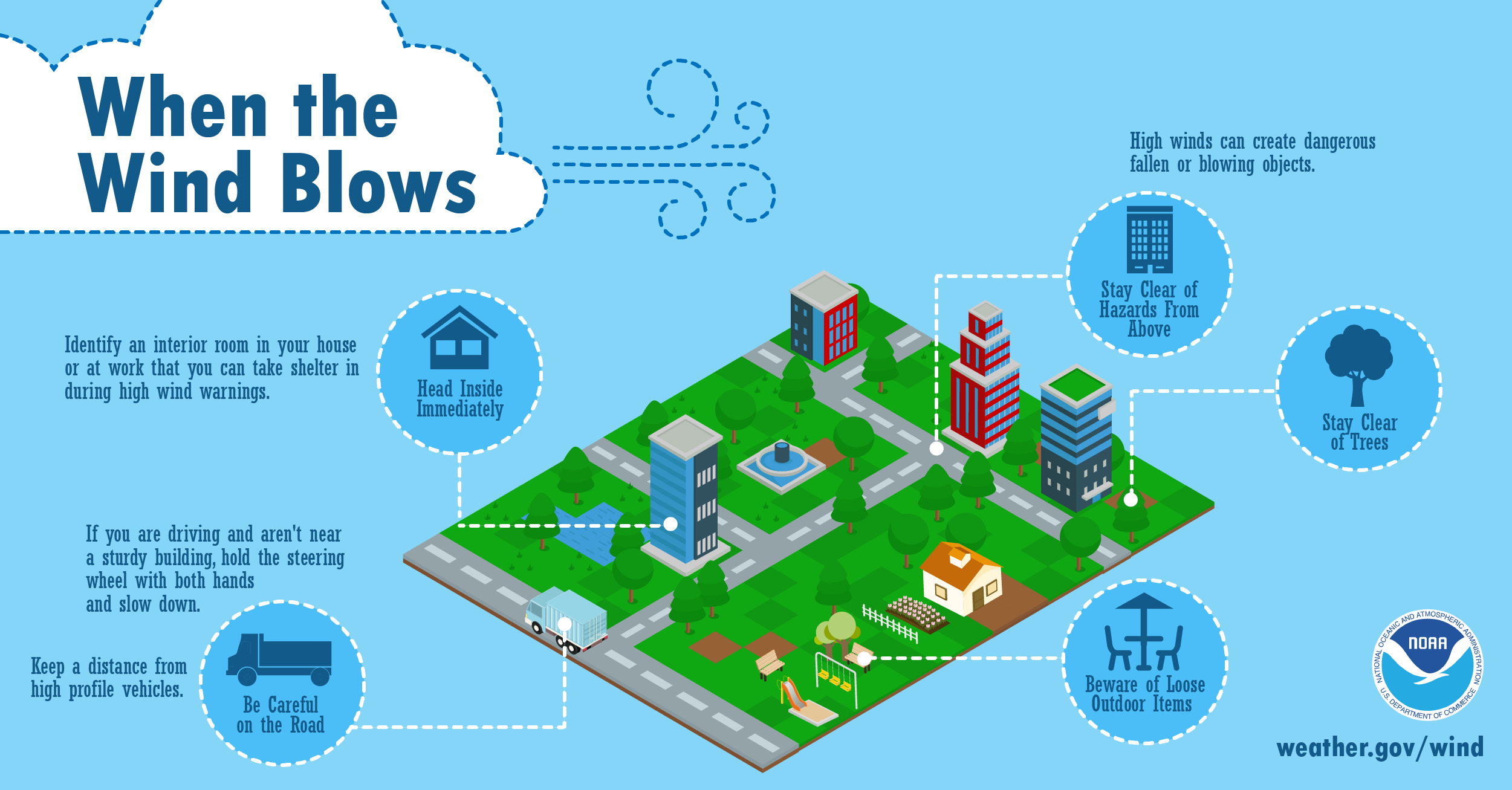
High Winds
Keep in mind that even tropical storm force winds (39 to 73 mph) are capable of tossing around debris and causing damage. For this reason, you should seek shelter from the wind in a sturdy building as the hurricane moves inland and before the onset of tropical storm force winds. Tropical storm force winds usually strike hours ahead of the actual hurricane’s eye. For this reason many emergency officials typically have evacuations completed and personnel sheltered before the onset of tropical storm force winds.
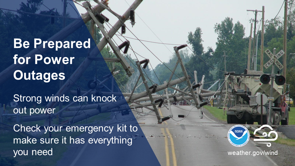
Hurricane force winds can easily destroy poorly constructed buildings and mobile homes. Debris such as signs, roofing material, and items left outside become flying missiles in high wind. Falling trees cause extensive damage to power lines, towers and underground water lines. This can cause extended disruptions of utility services. Damaging hurricane force winds can be just as devastating as tornadoes.
High Wind Infographics
 |
 |
 |
 |
 |
 |
Wednesday
Get Moving When a Storm Threatens
Audio PSA of the day (~ 30 seconds)
|
|
|
|
|
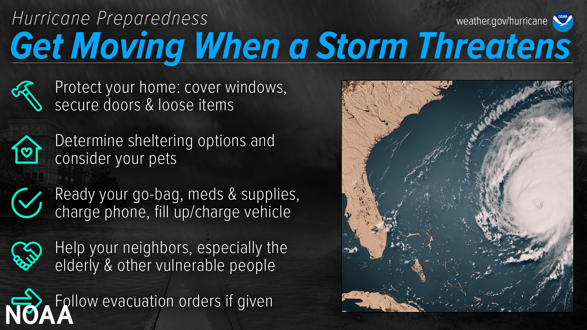
When a storm is forecast to impact your area, take action immediately to be ready. Ideally, longer-term preparedness actions such as having disaster supplies and an evacuation plan will have already been done before hurricane season, when the stores are stocked and time is on your side. When a storm threatens, there’s a lot more to do.
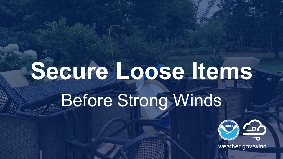
Protect your home
While longer-term home improvement needs to be done well ahead of time, when a storm threatens there are short-term actions to help protect your property. Board up windows, secure loose outdoor items, and secure all exterior doors. Move your vehicle to a safe location if you’re not using it to evacuate. If you are evacuating, unplug electrical equipment such as radios, televisions and small appliances (freezers and refrigerators also need to be unplugged if there is a risk of flooding). If you are instructed to do so, shut off water, gas and electricity before leaving.
Determine sheltering options & consider your pets
Check with local officials to find out what shelter spaces are available. If you have pets, find a place where they can stay — most public shelters only allow service animals. In general, have multiple sheltering options, including distant ones such as a friend’s home outside of the impact area, or a motel. Depending on the circumstances, your home may need to be your shelter — make sure it is prepared and that you know the safest places inside.
Ready your go-bag, meds & supplies, charge phone, fill up/charge vehicle
Have a go bag ready to take things with you if you need to leave in a hurry. In addition to basic survival needs, don’t forget other supplies such as chargers and hygiene products. Plan to have enough for at least three days, and don’t forget about your pets. While preparing these basic needs, don't forget to keep your phone charged, and make sure to fill up/charge your vehicle as well.
Your go-bag should also contain important personal and property documents, including your written communication plan.
Help your neighbors, especially the elderly & other vulnerable people
Many people rely on their neighbors before and after a disaster, and there are many ways you can help them. Help them prepare for a storm, and help them evacuate if needed. Share the latest forecast information with your community so that they know what to expect.
Follow evacuation orders if given
Always follow evacuation orders from local authorities — don’t wait for a hurricane to intensify before deciding to follow the order. You want to leave early enough to avoid being trapped by severe weather. If time allows, unplug electrical equipment, leave a note detailing your whereabouts, and check to see if any neighbors need a ride.
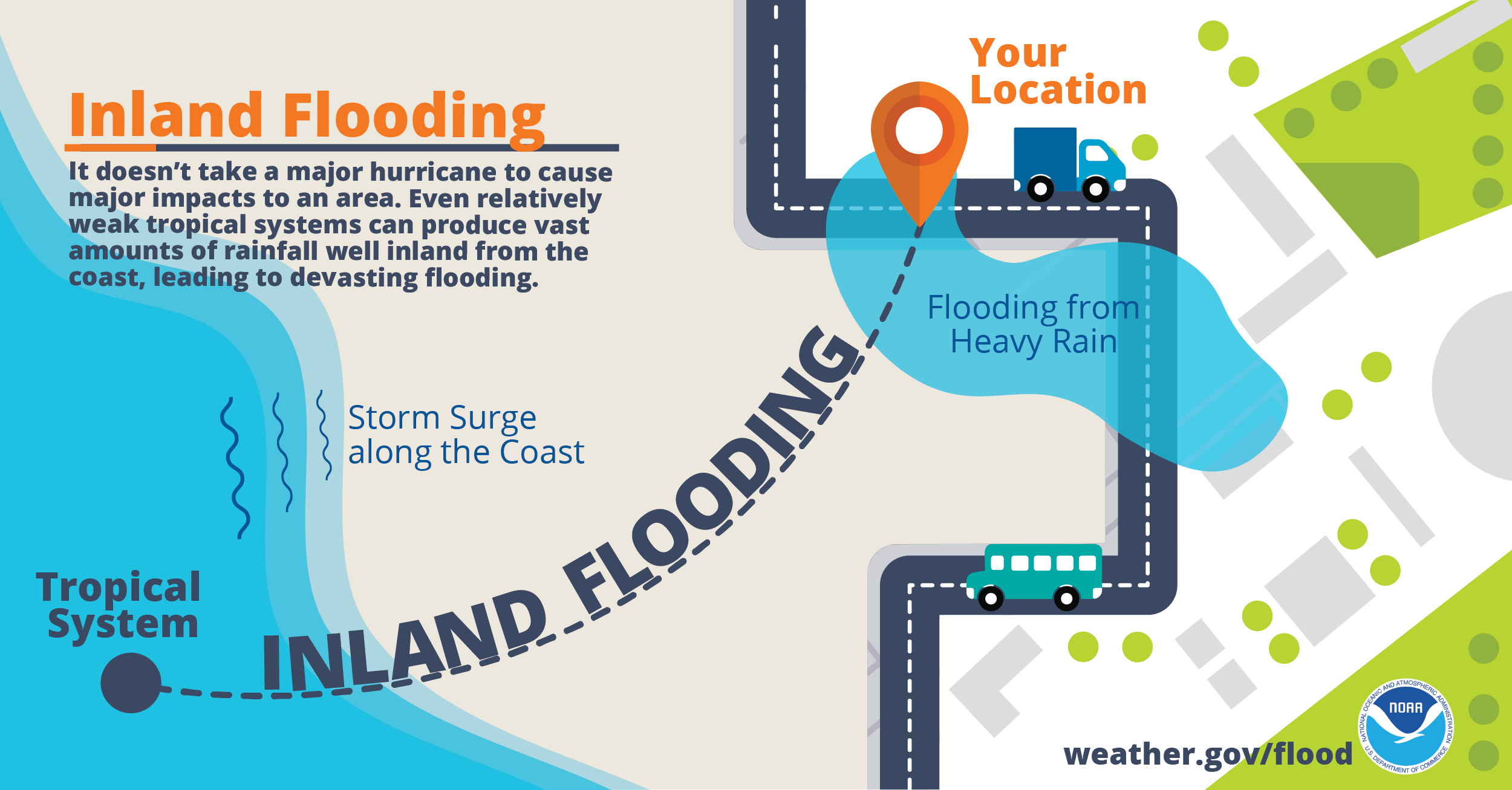
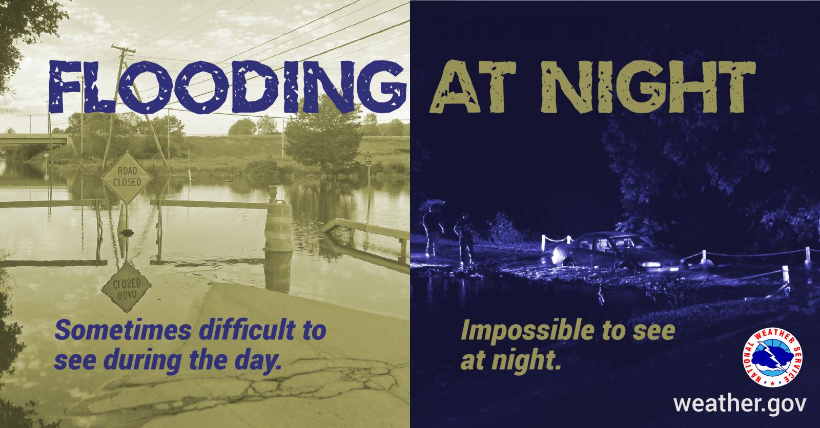
Inland Flooding
Hurricane Florence Makes Landfall In 2018
Inland flooding is the most deadly and serious threat hurricanes bring to inland areas of North Carolina. Hurricane Matthew in October 2016 generated record flooding across much of the coastal plain of North Carolina, claimed 28 lives, and left thousands homeless and entire towns under water. More recently, Hurricane Florence once again produced devastating inland flooding, and resulted in 11 flood-related deaths in North Carolina. Overall, most hurricane deaths over the past 30 years have been the result of flooding, many of which have occurred in automobiles as people attempt to drive through flooded areas where water covers the road. It is important to realize the amount of rain a tropical system produces is not related to the intensity of the wind. Weak hurricanes and even tropical storms have caused disastrous floods throughout history.
So what can you do? Anytime a hurricane or tropical storm threatens, think flooding. It is very important to determine if you live in an area at risk of flooding. If your yard or nearby roads around your home flood during ordinary thunderstorms, then you are at serious risk of flooding from torrential tropical rainfall. Those living near creeks, streams and drainage ditches should also closely watch water levels. Remember, extreme rainfall events bring extreme flooding typically not experienced in the past. During extreme events even those area which normally do not flood are at risk.
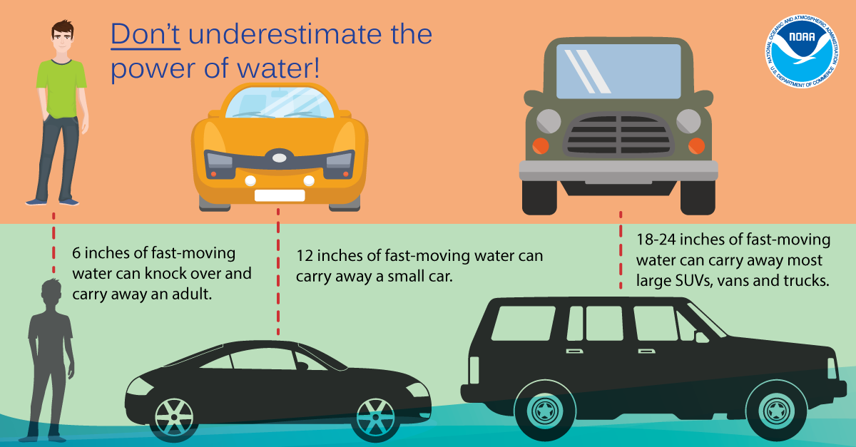
Always stay aware of road conditions and make sure your escape route is not becoming flooded by heavy rain. Never attempt to cross flowing water; instead, remember to turn around, don't drown. The reason that so many people drown during flooding is because few of them realize the incredible power of water. A mere six inches of fast-moving flood water can knock over an adult. It takes only two feet of rushing water to carry away most vehicles. This includes pickups and SUVs. Never allow children to play near streams, creeks or drainage ditches. As rain water runs off, streams, creeks, and ditches fill with running water that can easily sweep a child away.
Inland Flooding Infographics
 |
 |
 |
 |
 |
 |
View Video For More
Thursday
Stay Protected During Storms
Audio PSA of the day (~ 30 seconds)
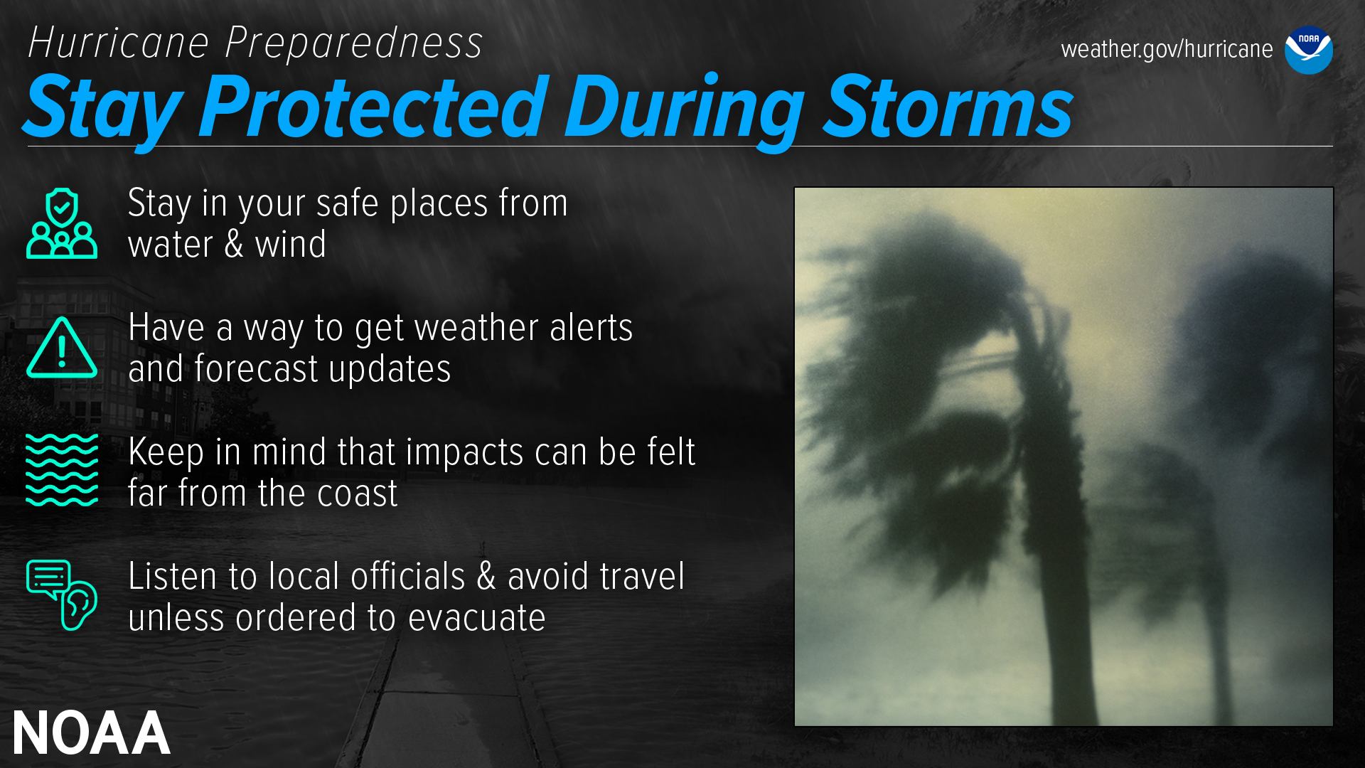
During a storm, whether you’ve evacuated or are sheltering in place, know what to expect from the hazards you may face. Remain vigilant, stay up-to-date with the latest forecasts and alerts, and continue to listen to local officials.
Stay in your safe places from water & wind
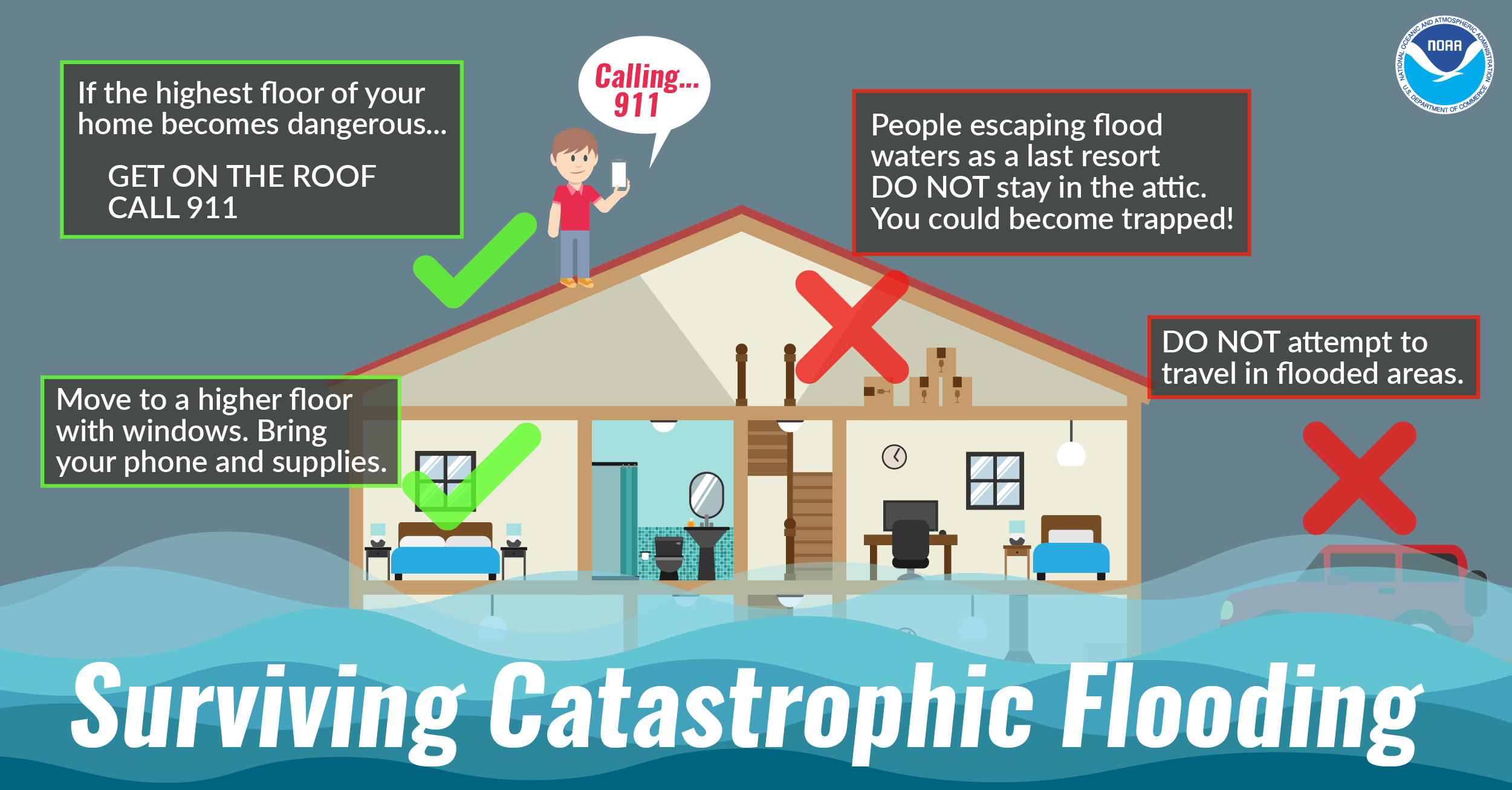
Always keep a safe distance from flooded and damaged areas. When you’re at risk from storm surge or flooding, it’s important to get to high ground away from bodies of water and any flood-prone areas. Evacuate if told to do so. Never drive through floodwaters or compromised bridges. Always pay attention to barriers and signage.
If your house becomes flooded and you’re still there, get higher in your house to escape the flood waters. If the highest floor of your home becomes dangerous, get on the roof and call 911.
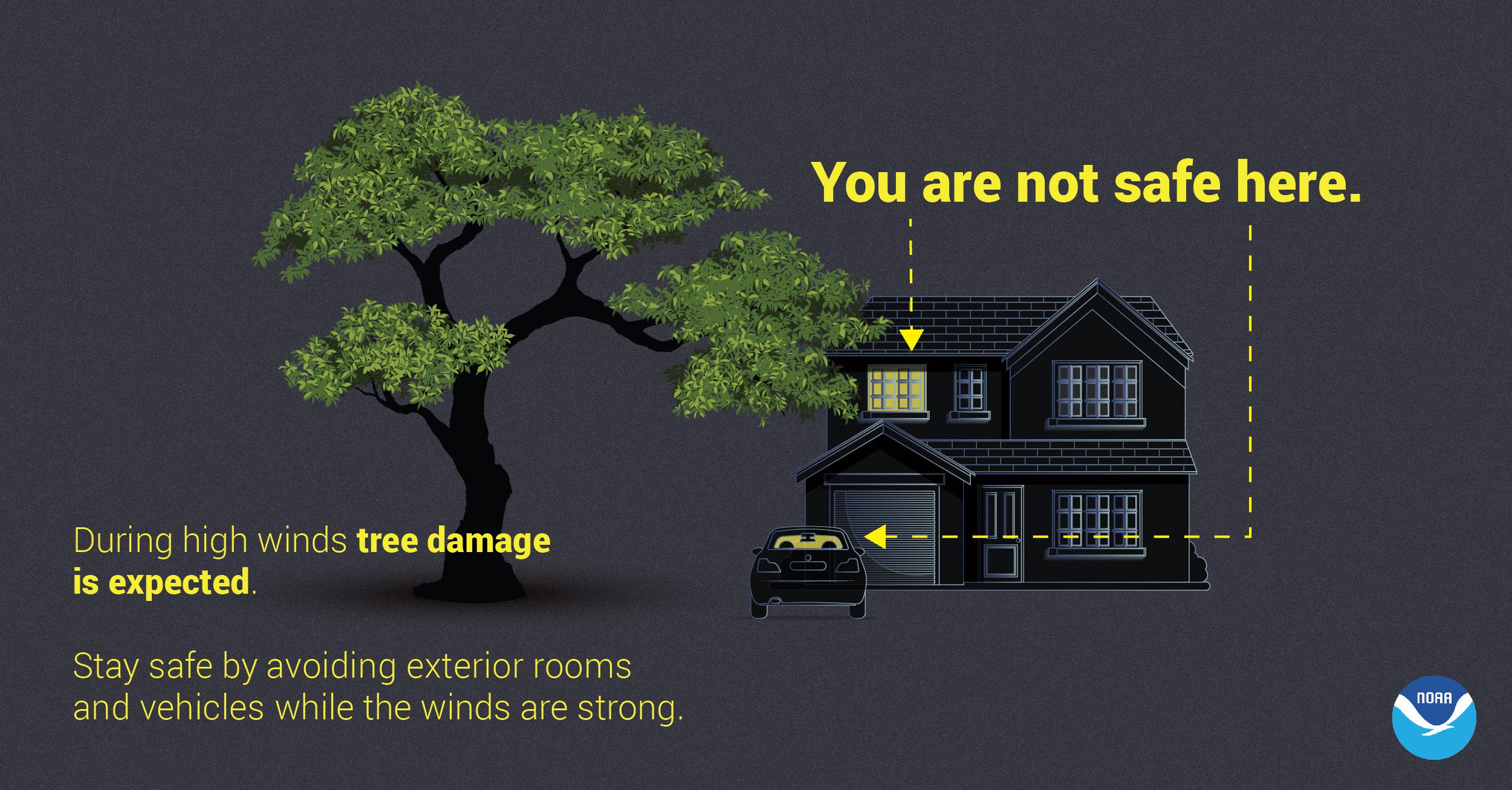
Though rain and storm surge cause more direct deaths, wind can also be very destructive and deadly in hurricanes. Winds can be stronger higher above ground level. This can put high-rise buildings at a greater risk. To protect yourself from wind, the best thing you can do is put as many walls as possible between you and the outside. An interior room without windows is the safest place you can be in a building. You can cover yourself with a mattress and wear a helmet for added protection. If your area is under an Extreme Wind Warning, take shelter immediately. Make sure to stay sheltered until the threat is gone.
Have a way to get weather alerts and forecast updates
Make sure to have Wireless Emergency Alerts enabled on your phone to receive Warnings and other alerts. Always pay attention to the latest forecast as conditions can change quickly and storms can rapidly intensify from a tropical storm to a major hurricane. Even small changes in the storm’s track can make a big difference.
Keep in mind that impacts can be felt far from the coast
Remain vigilant even if you’re far from the most damaging winds. Inland flooding can be felt hundreds of miles from the coast. Never drive through floodwaters! A car can be swept away with only a foot of water, and there’s no way to know if the road itself has collapsed when hidden by water.
Listen to local officials & avoid travel unless ordered to evacuate
Local officials can provide you with up-to-date information as the situation changes in your area. Evacuation orders may still be given at this late stage — leave immediately if ordered! Follow recommended evacuation routes — do not take shortcuts, as they may be blocked. Be alert for road hazards such as washed-out roads or bridges and downed power lines. Never drive through floodwaters.
Tornadoes
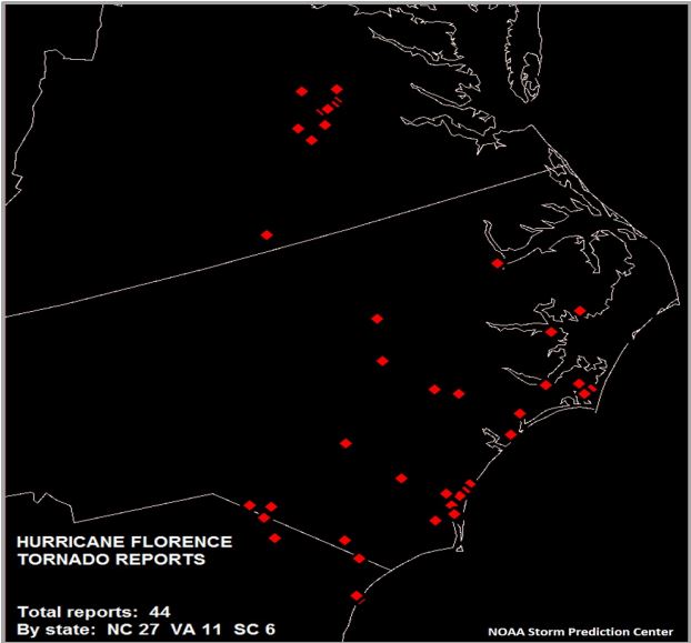
ANY tropical system is capable of producing tornadoes! Tropical tornadoes are often short lived but they can produced enhanced areas of damage. Sometimes these tornadoes can occur in the outer rain bands, well ahead of the center of the storm. In 2019 Hurricane Dorian produced an EF-2 tornado in Emerald Isle, NC with estimated winds of 115 MPH. In 2018, Hurricane Florence produced 27 tornadoes in North Carolina! To prepare for the possibility of tornadoes it's important to have multiple ways to receive warnings, so you can seek shelter quickly if a warning is issued for your area.
Hurricane Florence Tornado Reports
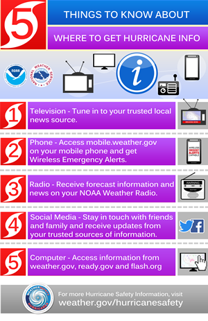
Identify Your Trusted Sources of Information
​
NOAA's National Hurricane Center is your official source for hurricane forecasts and the issuance of hurricane watches and warnings. Your local NOAA National Weather Service forecast office provides information regarding the expected impacts from the storm for your area. Emergency managers will make the decisions regarding evacuations.
Organizations such as FLASH make disaster safety recommendations. And the media outlets will broadcast this information to you. All work together to be your trusted sources, especially for those less able to take care of themselves.
Here are some additional suggestions regarding where to get trusted tropical storm and hurricane information:
 |
 |
 |
View Video For More
Friday
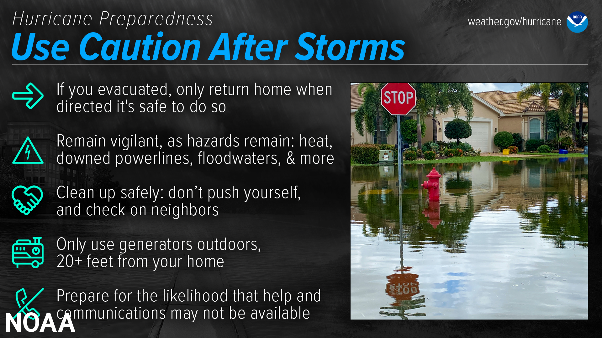
Use Caution After Storms
Audio PSA of the day (~ 30 seconds)
Dangers remain even after the skies turn blue. This is NOT the time to put your guard down. Nearly half of hurricane fatalities occur after the storm.
If you evacuated, only return home only when told to do so
Return home ONLY when officials say it is safe. ​​Check with local officials both where you’re staying and back home before you travel.
Remain vigilant, as hazards remain
Clean up safely: don’t push yourself, and check on neighbors
Stay hydrated, wear light, loose-fitting clothing, and clean up during cooler hours if possible. Don’t push yourself: straining the body can lead to heart attacks, heat strokes, and other serious issues. Perform cleanups slowly, taking lots of breaks. Make sure to check on your elderly neighbors and other vulnerable people in your community. If your area is under a Heat Advisory, use extreme caution and consider cleaning up when the heat has subsided.
Practice portable generator safety
Be very careful with portable generators: carbon monoxide poisoning is one of the leading causes of death in areas dealing with power outages. Never use a generator inside your home or garage, even if doors and windows are open. Only use generators outside, more than 20 feet away from your home, doors, and windows.
Help and communications may not be readily available
After a hurricane, emergency responders may be overwhelmed. Be aware that it could take hours or days for them to reach your area. Communication systems may be impacted, and making phone or video calls might be difficult due to network congestion. If possible, communicate via text, email, or social media.
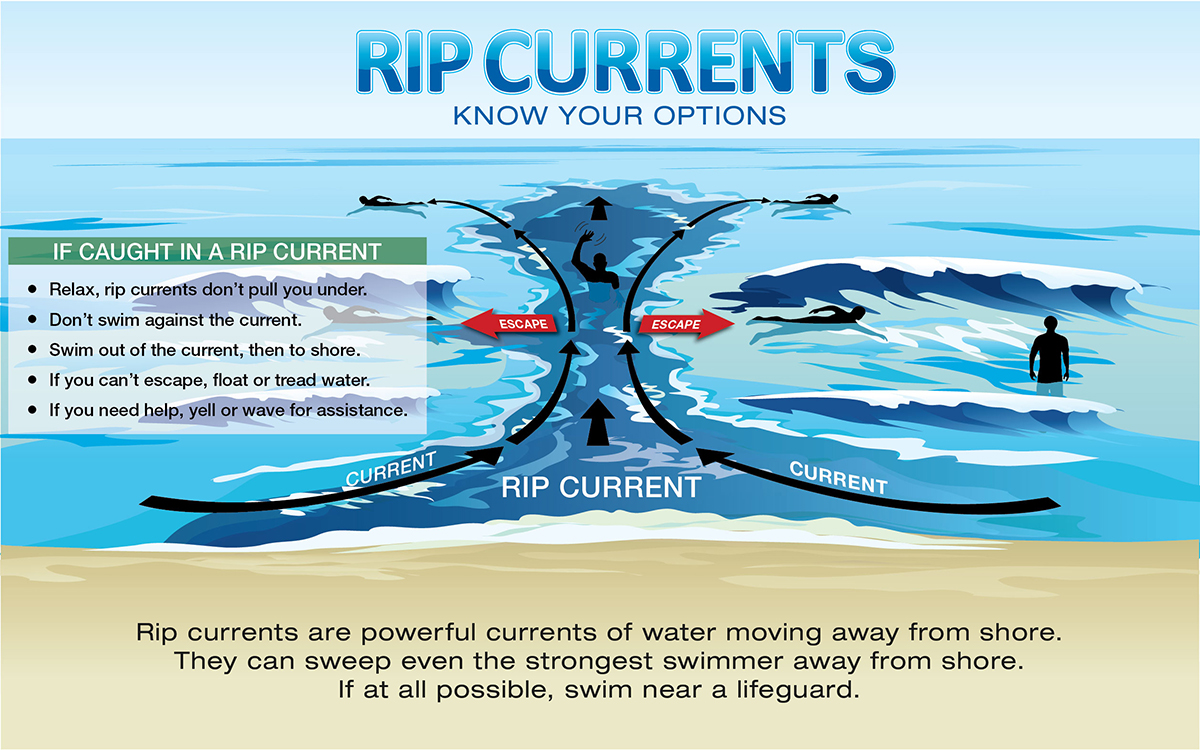
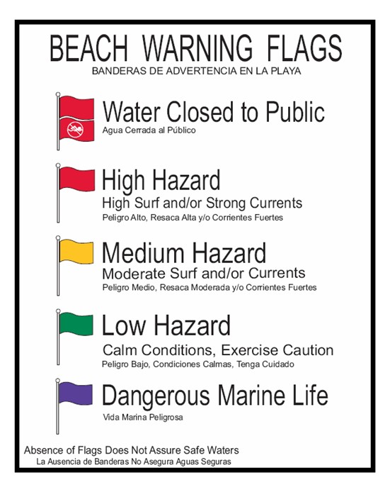
Rip Currents
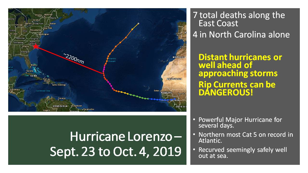
Even when hurricanes stay out at sea, the North Carolina coast can still be impacted by large swells and deadly rip currents, thus making it important to stay aware of the tropics and weather forecasts all throughout the hurricane season. Rip currents are channelized currents of water flowing away from shore at surf beaches. Rip currents are quite common and can be found on many surf beaches every day. They typically form at breaks in sandbars, and also near structures such as jetties and piers. While the risk of rip currents occurring along the North Carolina beaches increases when a tropical cyclone is out in the Atlantic, the risk increases even more so when a tropical cyclone is moving toward the North Carolina coast, especially when the storm is a day or two away from making landfall along the Carolina coast.
Rip currents are dangerous because they can pull people away from shore. Rip current speeds can vary from moment to moment and can quickly increase to become dangerous to anyone entering the surf. Rip currents can sweep even the strongest swimmer out to sea. Some clues that a rip current may be present include a channel of churning, choppy water, a difference in water color, a break in the incoming wave pattern, and a line of foam, seaweed or debris moving seaward.
If you find yourself caught in a rip current, stay calm and don’t fight the current. Escape the current by swimming in a direction following the shoreline. When free of the current, swim at an angle—away from the current—toward shore. If you are unable to escape by swimming, float or tread water. When the current weakens, swim at an angle away from the current toward shore. If at any time you feel you will be unable to reach shore, draw attention to yourself: face the shore, call or wave for help. Also, don’t become a victim while trying to help someone else! Many people have died in efforts to rescue rip current victims. Instead, get help from a lifeguard. If a lifeguard is not present, yell instructions on how to escape. If possible, throw the rip current victim something that floats. Call 9-1-1 for further assistance.
Hurricane Lorenzo
Rip Current Safety
Beach Flags
View Video For More
Saturday
Take Action Today
Audio PSA of the day (~ 60 seconds)
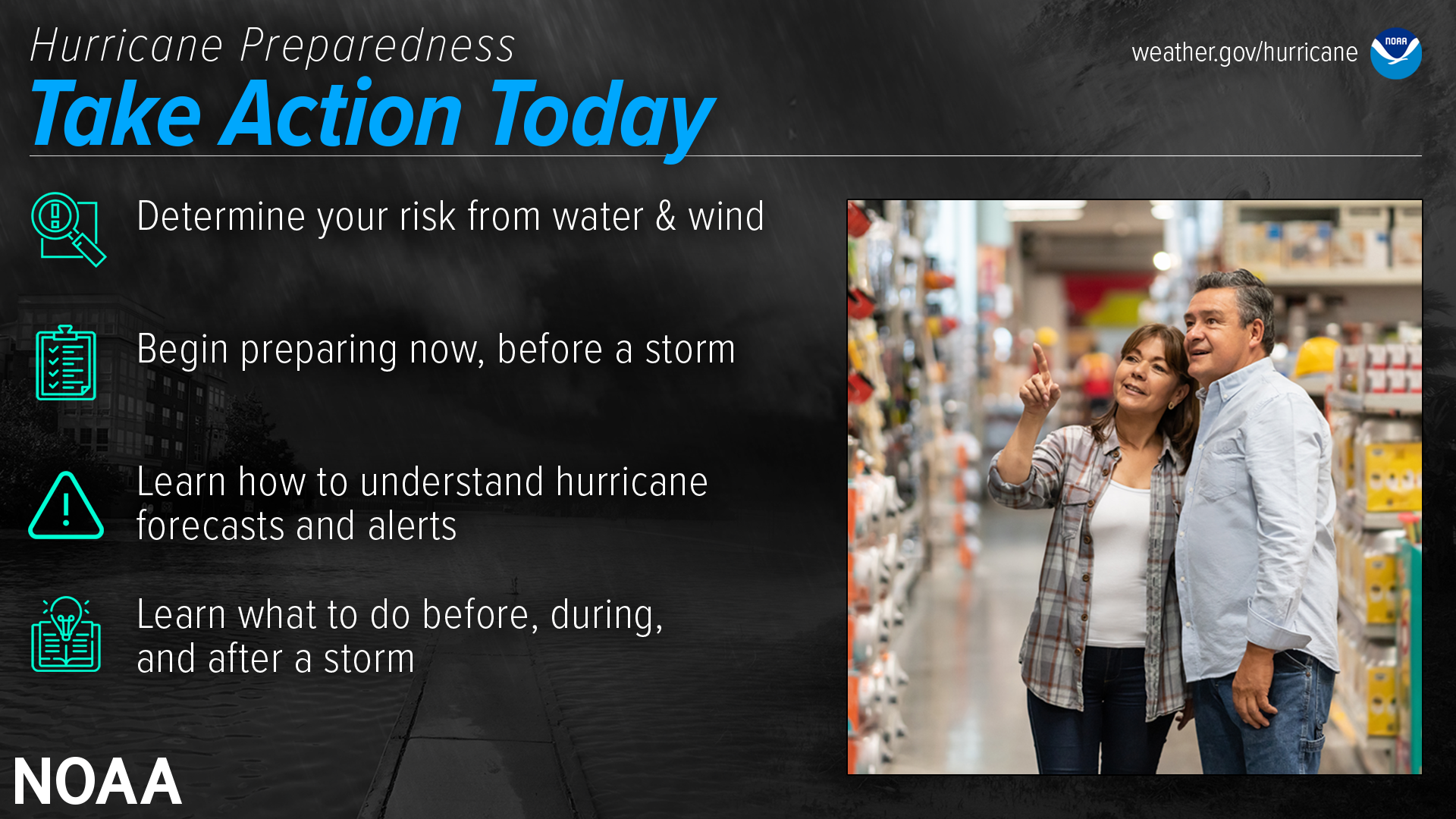
Are you ready for hurricane season? Take action TODAY to be better prepared for when the worst happens. Understand your risk from hurricanes, and begin pre-season preparations now. Make sure you understand how to interpret forecasts and alerts, and know what to do before, during, and after a storm. Even if you are already well-prepared and knowledgeable, there may be additional things you could do or learn to be even more prepared.
Complete Your Written Plan
The time to prepare for a hurricane is before the season begins, when you have the time and are not under pressure. If you wait until a hurricane is on your doorstep, the odds are that you will be under duress and will make the wrong decisions. Take the time now to write down your hurricane plan. Know where you will ride out the storm and get your supplies now. You don’t want to be standing in long lines when a hurricane warning is issued. Those supplies that you need will probably be sold out by the time you reach the front of the line. Being prepared, before a hurricane threatens, makes you resilient to the hurricane impacts of wind and water. It will mean the difference between your being a hurricane victim and a hurricane survivor.
Here are some things to know about completing a written hurricane plan:
To make developing your family emergency plan easy, be sure to download a free template that is available online at http://readync.org.
Deaf & Hard of Hearing
#SeeAFlashDashInside
Hurricane awareness in American Sign Language! Check out this video that covers National Weather Service information, safety, preparedness, and more. Also captioned in English! youtu.be/xKdkYi9VAxY
Hurricane Awareness (ASL Video)
Severe Thunderstorm Safety (ASL Video)
Do you see a lot of strong thunderstorms in your area?
Check out this video in American Sign Language from the National Weather Service
to learn about what you need to know for the next big storm! youtu.be/V-t-9R2o8No
Tornado Safety (ASL Video)
You may only have seconds to get to your safe place when the next tornado occurs!
Learn where to shelter and how to get warning information from the National Weather Service with this video in American Sign Language!
youtu.be/aEPC5F4Zios
See a Flash, Dash Inside (ASL Video)
If you are outdoors and see a flash of lightning or feel the rumble of thunder, dash inside immediately! Check out our Lightning Safety video in American Sign Language and captioned in English!
Flood Safety Video (ASL Video)
Did you know flooding is the leading cause of death due to storms? Learn more about Flood Safety with this video in American Sign Language and captioned in English! youtu.be/RUf3ErtEbG4
NOAA Weather Radio (ASL Video)
NOAA Weather Radios receive warnings, watches, forecasts, and other hazard information 24 hours a day. Why would Deaf people want a radio? They can be used as a way to alert you or wake you up at night! Some come with flashing lights, vibrating alarm attachments, and color displays with text readouts for use by those with hearing loss. youtu.be/A4izxOnKnug
General Safety and Preparedness Tips (ASL Video)
Having a plan is important in times of emergency, and this includes building an emergency preparedness kit before a disaster. Learn how with this video in American Sign Language.
youtu.be/XWEvqy0e9-0
Hurricane Preparedness (Español)
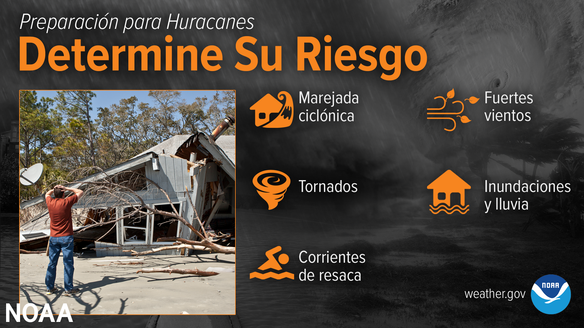
Determine Su Riesgo
Las amenazas de los huracanes hacia usted y su familia pueden variar grandemente dependiendo de donde usted reside. No son sólo aquellos a lo largo de la costa los que pueden experimentar impactos significativos para la vida. Evalúe lo que usted necesita hacer para proteger su hogar y familia AHORA, antes que se forme la próxima tormenta.
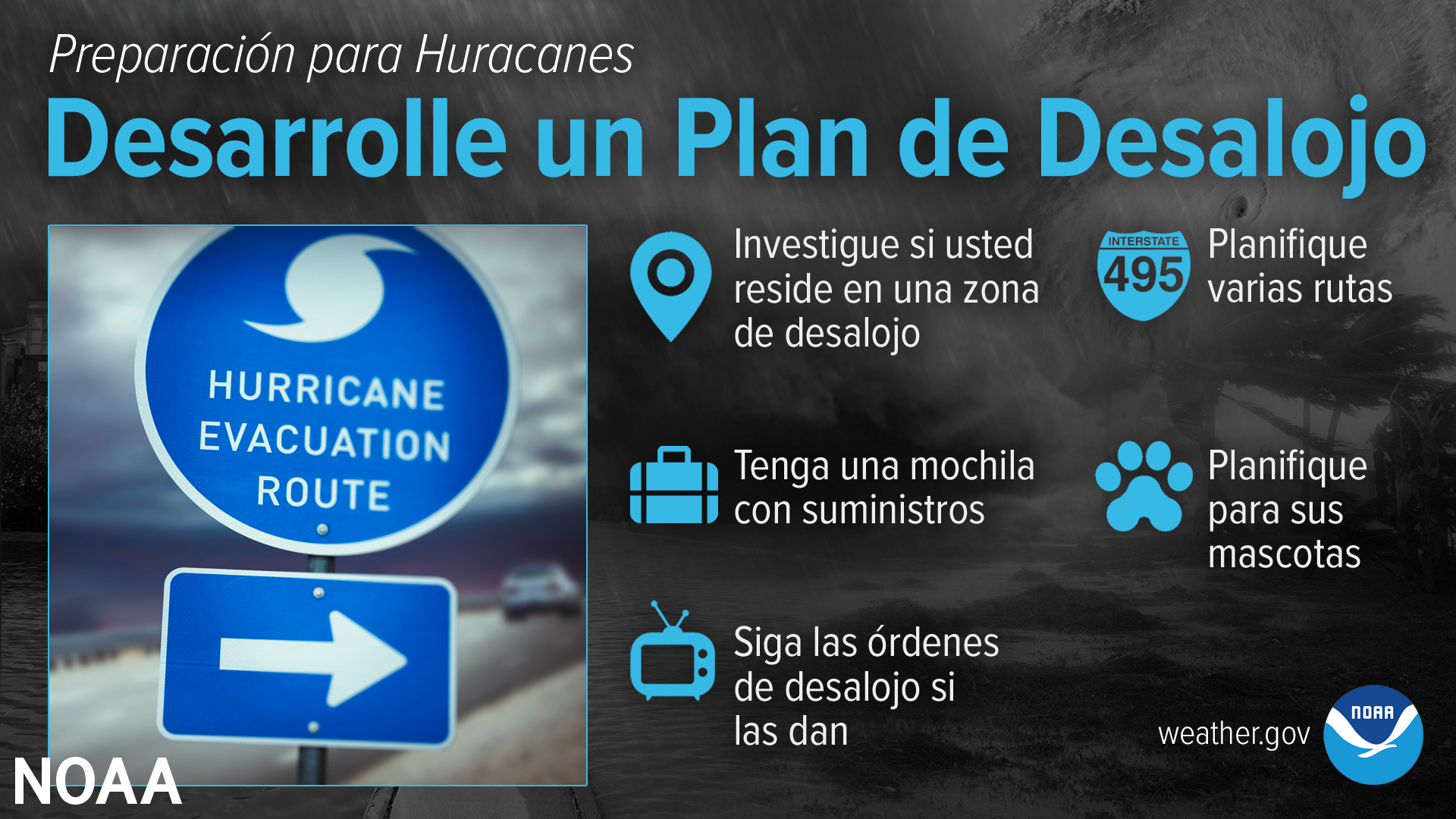
Desarrolle un Plan de Desalojo
Tome tiempo para asegurarse que cuenta con un plan de desalojo. Lo primero que debe hacer es averiguar si reside en una zona de desalojo por las marejadas ciclónicas o si su casa sería un lugar inseguro durante un huracán. Si el lugar es inseguro, piense a dónde iría en caso de un desalojo y cómo llegará allí. No tiene que viajar cientos de millas. Identifique a una persona, algún pariente o amigo, que no resida en una zona de desalojo o casa insegura, y coordine con esta persona si puede utilizar su residencia como su destino de desalojo. Asegúrese de tener un plan para su mascotas, ya que la mayoría de los refugios no las aceptan. Tenga un plan por escrito para usted y sus familiares.
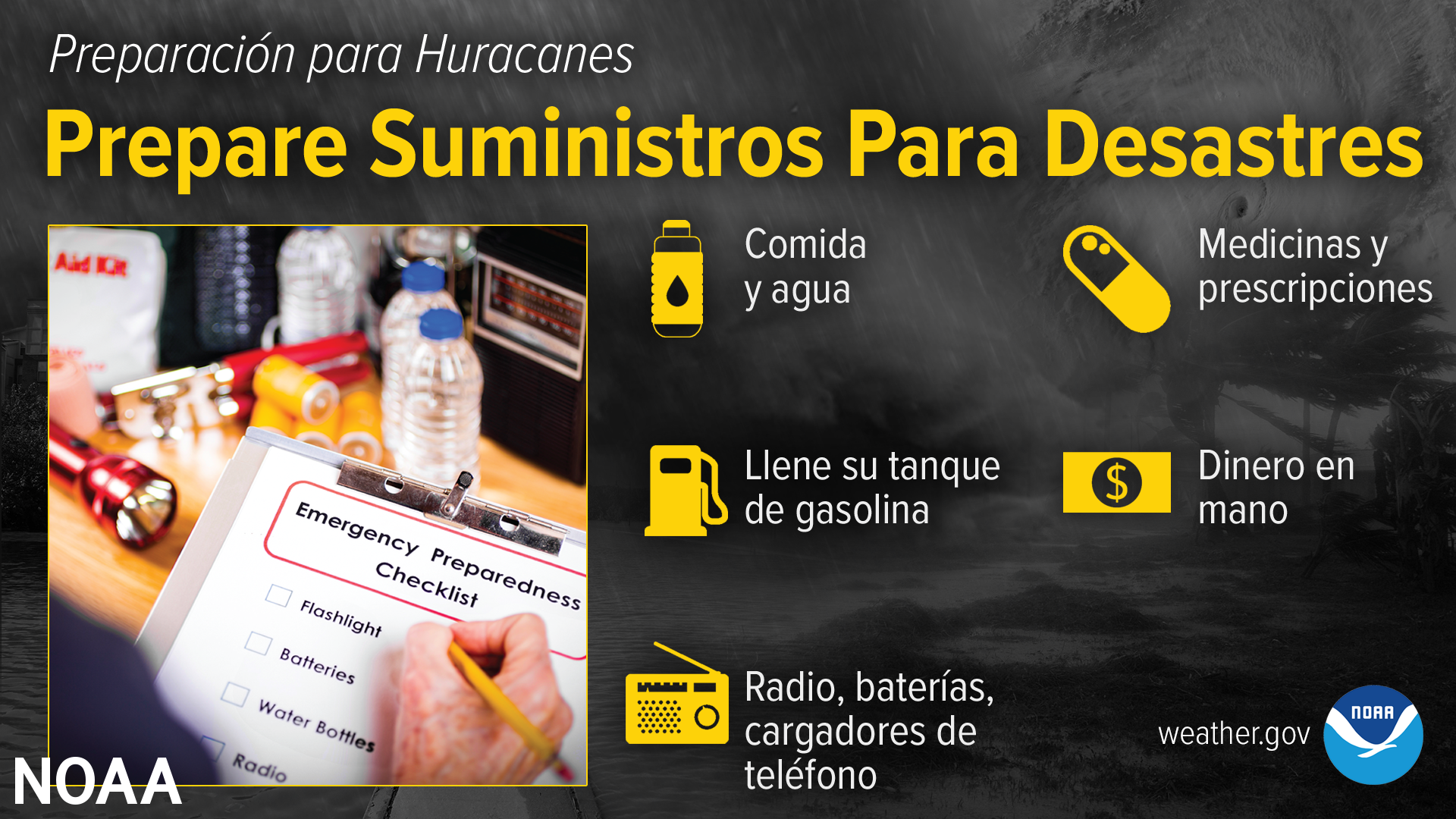
Prepare Suministros Para Desastres
Tener sólo suministros para pasar el huracán no va a ser suficiente. Usted va a necesitar mucho más para poder subsistir a lo que podría ser un LARGO periodo de recuperación. La electricidad y el agua podrían estar sin funcionamiento por una o más semanas. Cuente con suficiente comida no perecedera, agua y medicinas para cada miembro de su familia para AL MENOS tres días. También, asegúrese de tener dinero en efectivo, radios de baterías, linternas, y un cargador de manivela portátil o solar para recargar su teléfono celular. ready.gov/es/kit
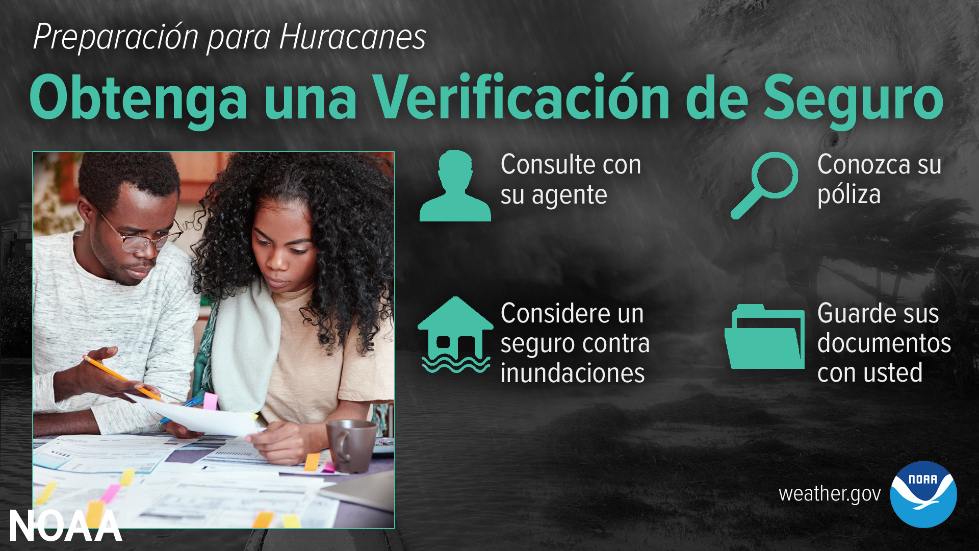
Obtenga una Verificación de Seguro
Llame a su compañía o agente de seguros y pregunte por una verificación de su póliza para asegurarse que cuenta con suficiente cobertura para reparar o incluso reemplazar su casa...y recuerde, las pólizas de seguros para los dueños de casas no incluyen cobertura de inundaciones. Ya sea si es dueño de una casa o la renta, usted ha de necesitar una póliza de seguros de inundaciones por separado. floodsmart.gov/es/. Actúe ahora ya que los seguros de inundaciones requieren un periodo de espera de 30 días.
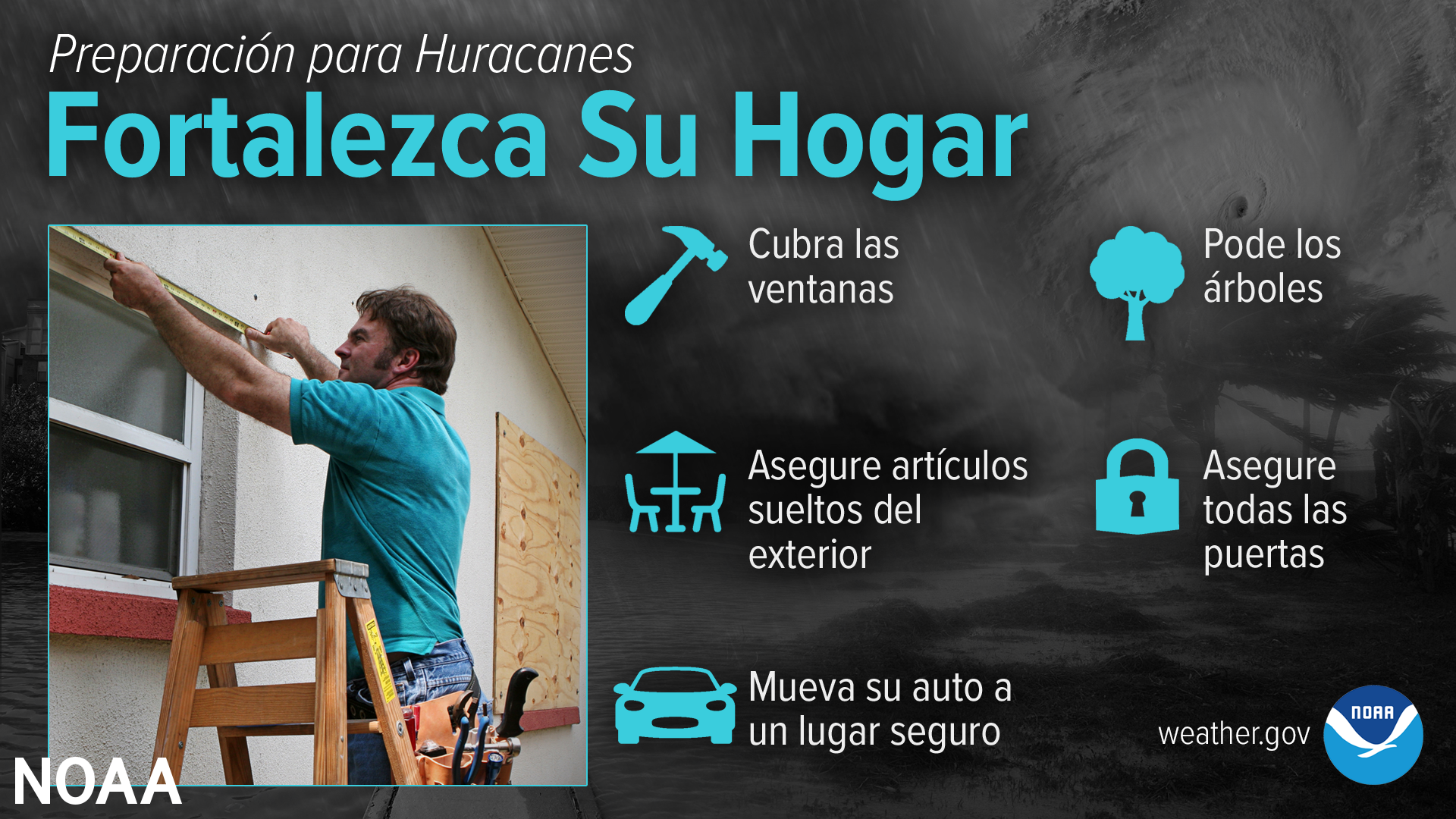
Fortalezca Su Hogar
Si usted planifica permanecer en su hogar durante un huracán, asegúrese que esté en buenas condiciones y bajo las especificaciones de los códigos de construcción local. Tenga paneles de madera, acero o aluminio apropiados para proteger sus puertas y ventanas. Recuerde, la puerta del garaje es la parte más vulnerable de la casa, y necesita poder resistir a los fuertes vientos.
flash.org/espanol.php
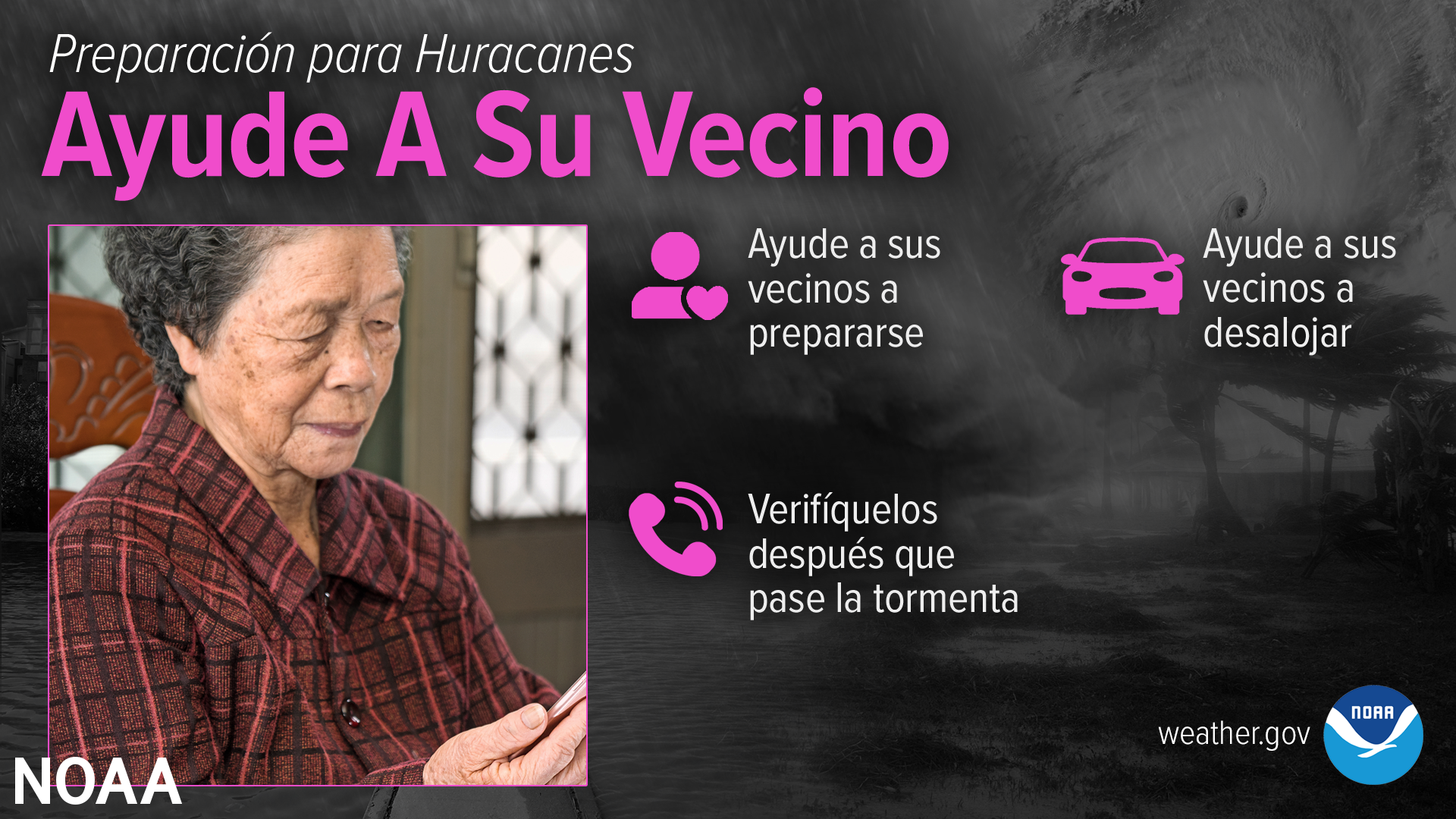
Ayude A Su Vecino
Muchos americanos dependen de la asistencia de sus vecinos luego de un desastre, pero existen muchas maneras en que usted puede ayudar a su vecino antes que se acerque un huracán. Aprenda sobre todas aquellas acciones que su comunidad puede tomar para prepararse y recuperarse de las amenazas asociadas a los huracanes en: ready.gov/es/vecinos%60
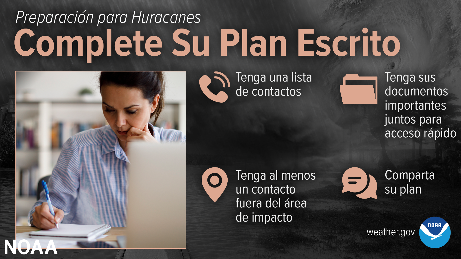
Complete Su Plan Escrito
El momento para prepararse para los huracanes es AHORA, antes de que se forme la próxima tormenta o huracán.
Sepa dónde pasaría una tormenta y colecte suministros ahora. Usted no va a querer estar esperando en largas filas cuando se emita una Vigilancia de Huracán. Los suministros que necesita podrían acabarse antes de que usted llegue al comienzo de la línea.
El estar preparado desde ahora podría significar la diferencia entre usted ser una víctima del huracán o un sobreviviente del mismo.
ready.gov/es/haga-un-plan
Aviso vs Vigilancia de Inundaciones (Flood Warning vs. Watch)
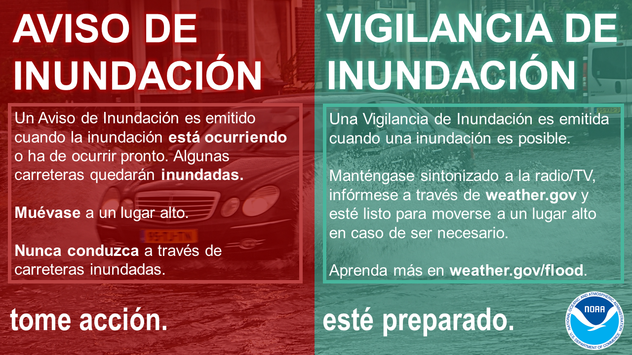
Un AVISO de inundación significa TOMAR ACCIÓN. Una VIGILANCIA de inundación significa PREPARARSE. Cuando se emite un Aviso, significa que inundaciones son inminentes o que ya están ocurriendo. Cuando una Vigilancia de Inundación está en efecto, significa que es posible que ocurra una inundación en su área. weather.gov/safety/flood-watch-warning #FloodSafety
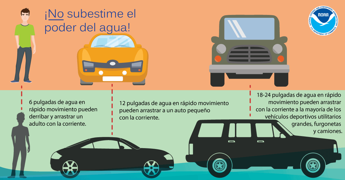
Graifica - El Ponder del Agua (Infographic - Power of Water)
No subestime el poder del agua. Sólo se necesitan 6 pulgadas de agua en rápido movimiento para derribar y arrastrar a un adulto, y 12 pulgadas de agua para arrastrar a un automóvil pequeño. ¡Dé la Vuelta, No Se Ahogue! weather.gov/safety/flood-turn-around-dont-drown
Find us on social media:
You can also contact:
Erik Heden (Erik.Heden@noaa.gov) for additional information about Hurricane Preparedness.


 Youtube
.png) Surf Forecast/Rip Currents
Surf Forecast/Rip Currents Map View
 Weather Hazard Briefing (when applicable)
 Forecaster Discussion
 Marine
 Text Products
.png) Skywarn
Skywarn Submit Storm Reports
 Coastal Flood