Event Overview
Hurricane Hanna was the deadliest storm of the 2008 Atlantic hurricane season. The storm was the eighth tropical cyclone and fourth hurricane of the 2008 Atlantic hurricane season. It formed east-northeast of the northern Leeward Islands on August 28. The cyclone struck Myrtle Beach, South Carolina, before moving up the Eastern Seaboard to become an extratropical cyclone as it moved by New England into the Canadian Maritimes early on September 7 (Figure 1). At least 537 deaths were reported (the final death toll will likely never be known), mostly due to flooding in the northern part of Haiti, making it the deadliest tropical cyclone in the Atlantic basin in 2008. Hanna also caused $160 million in damages to the United States.
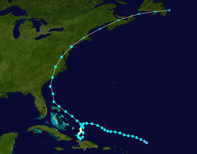
Figure 1. Track of Hurricane Hanna, August 28 through September 7, 2008
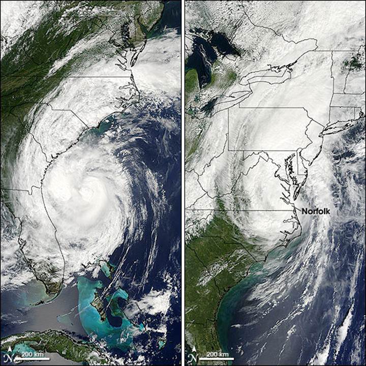
Figure 2. Hurricane Hanna off the Georgia coast, then later as a Tropical Storm off the Virginia Coast (photo courtesy NASA).
Evolution and Impacts
On August 28, while to the east-northeast of the northern Leeward Islands, a tropical low formed into Tropical Depression Eight. Later that day, it attained tropical storm status, and was named Hanna. At the time, the low-level center of circulation was partially exposed on the western edge of the convection, indicating westerly wind shear. Tracking westward primarily under the steering current of a large ridge to the north, the convective pattern began to redevelop late on August 28. On September 1, as Hanna drifted to the south-southwest, convection increased and the storm began to intensify. Later that day around 1:30 pm EDT, an Air Force Reconnaissance Aircraft found winds within Hanna supportive of hurricane strength, and the National Hurricane Center upgraded Hanna to a hurricane. Early on September 2, strong wind shear in association with Hurricane Gustav began to affect Hanna and the storm was downgraded to a tropical storm on September 3. Early on September 6, 2008, Hanna made landfall near the South Carolina-North Carolina border. The system became an extratropical cyclone as it moved into Canada early on September 7 and raced across the North Atlantic.
In Eastern North Carolina, storm surge was estimated at 2 to 3 feet with minor beach erosion in Onslow and Carteret counties and along the Outer Banks. A surge of 4.5 feet along the Pamlico River at Washington resulted in some flooding of low lying areas in Washington and Belhaven. Storm surge estimated at 2 to 4 feet occurred along the Neuse River in Craven County.
The inland counties of Pitt, Jones, Washington, Craven, Duplin and Beaufort all reported minor wind damage with trees and power lines down, some shingles blown off homes, and $10,000 worth of damage was reported to two accessory buildings in Washington County. There were sporadic power outages throughout eastern North Carolina.
Heavy rainfall (Figure 3) during the morning of September 6 across the southwestern portion of Hyde County produced flooding in the Sladesville area resulting in Sladesville Credle Road becoming impassible.
While no deaths or injuries were reported in North Carolina, 7 deaths were reported along the east coast of the United States, mainly rip current related drownings, due to Hanna.
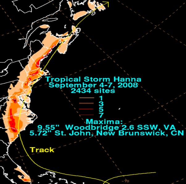
Figure 3. Rainfall totals along the track of Hanna (September 4-7, 2008).
POST TROPICAL CYCLONE REPORT...HURRICANE HANNA
NATIONAL WEATHER SERVICE NEWPORT/MOREHEAD CITY NC
410 PM EDT THU SEP 11 2008
NOTE: THE DATA SHOWN HERE ARE PRELIMINARY....AND SUBJECT TO UPDATES
AND CORRECTIONS AS APPROPRIATE.
THIS REPORT INCLUDES EVENTS OCCURRING WHEN WATCHES AND/OR WARNINGS
WERE IN EFFECT FOR HANNA.
COUNTIES INCLUDED...CARTERET...ONSLOW...DARE...CRAVEN...DUPLIN...
JONES...MARTIN...GREENE...LENOIR...PAMLICO...HYDE...BEAUFORT...
PITT...WASHINGTON...TYRRELL
A. LOWEST SEA LEVEL PRESSURE/MAXIMUM SUSTAINED WINDS AND PEAK GUSTS
---------------------------------------------------------------------
METAR OBSERVATIONS...
NOTE: ANEMOMETER HEIGHT IS 10 METERS AND WIND AVERAGING IS 2 MINUTES
---------------------------------------------------------------------
LOCATION ID MIN DATE/ MAX DATE/ PEAK DATE/
LAT LON PRES TIME SUST TIME GUST TIME
DEG DECIMAL (MB) (UTC) (KT) (UTC) (KT) (UTC)
---------------------------------------------------------------------
KMRH-BEAUFORT AIRPORT NC
34.72 76.65 998.9 06/1027 220/036 06/1406 220/048 06/1348
KEWN-NEW BERN NC
35.09 77.05 995.5 06/1111 180/031 06/1122 180/049 06/1118
KHSE-FRISCO AIRPORT NC
35.22 75.62 1001.9 06/1204 170/037 06/1144 160/047 06/1056
KPGV-GREENEVILLE AIRPORT NC
35.63 77.40 I 130/018 06/1043 I 130/027 06/1043 I
KOAJ- JACKSONVILLE AIRPORT NC
34.83 77.62 993.5 06/1043 170/037 06/1002 I
REMARKS:
NON-METAR OBSERVATIONS...
NOTE: ANEMOMETER HEIGHT IN METERS AND WIND AVERAGING PERIOD IN
MINUTES INDICATED UNDER MAXIMUM SUSTAINED WIND IF KNOWN
---------------------------------------------------------------------
LOCATION ID MIN DATE/ MAX DATE/ PEAK DATE/
LAT LON PRES TIME SUST TIME GUST TIME
DEG DECIMAL (MB) (UTC) (KT) (UTC) (KT) (UTC)
---------------------------------------------------------------------
B. MARINE OBSERVATIONS...
NOTE: ANEMOMETER HEIGHT IN METERS AND WIND AVERAGING PERIOD IN
MINUTES INDICATED UNDER MAXIMUM SUSTAINED WIND IF KNOWN
---------------------------------------------------------------------
LOCATION ID MIN DATE/ MAX DATE/ PEAK DATE/
LAT LON PRES TIME SUST TIME GUST TIME
DEG DECIMAL (MB) (UTC) (KT) (UTC) (KT) (UTC)
---------------------------------------------------------------------
41035 - ONSLOW BAY, NC
34.47 77.28 996.8 06/0920 140/035 06/0720 190/056 06/1020
41036 - ONSLOW BAY , NC
34.21 76.95 999.5 06/0850 140/037 06/0750 140/047 06/0750
CLKN7 - CAPE LOOKOUT , NC
34.62 76.53 1002.0 06/0900 MMM/039 06/0900 MMM/046 06/1250
41025 - DIAMOND SHOALS , NC
35.00 75.40 1004.8 06/1050 150/035 06/1050 190/049 06/1250
DUCN7 - DUCK PIER , NC
36.18 75.75 1001.6 06/1212 140/038
REMARKS:
C. STORM TOTAL RAINFALL FROM 1200 UTC SEP 05 UNTIL 1800 UTC SEP 07
---------------------------------------------------------------------
CITY/TOWN COUNTY ID RAINFALL
LAT LON (IN)
DEG DECIMAL
---------------------------------------------------------------------
BEAUFORT CARTERET MRH 1.08
34.72 -76.65
FRISCO OUTER BANKS DARE HSE 1.04
35.23 -75.61
CHERRY POINT MCAS CRAVEN NKT 1.30
34.92 -76.88
JACKSONVILLE ONSLOW OAJ 1.32
34.76 -77.40
NEW BERN CRAVEN EWN 0.81
35.11 -77.08
NEWPORT CARTERET MHX 1.11
34.78 -76.86
KINSTON LENOIR KNNN7 1.60
35.27 -77.59
WILLIAMSTON MARTIN WLLN7 2.00
35.85 -77.06
REMARKS:
D. INLAND FLOODING...
---------------------------------------------------------------------
HYDE...HEAVY RAINFALL DURING THE MORNING OF SEPTEMBER 6TH ACROSS THE
SOUTHWEST PART OF HYDE COUNTY PRODUCED FLOODING IN THE SLADESVILLE
AREA RESULTING IN THE SLADESVILLE CREDLE ROAD BECOMING IMPASSABLE.
---------------------------------------------------------------------
E. MAXIMUM STORM SURGE AND STORM TIDE...
OFFICIAL TIDE GAUGES NOTED WITH LEADING G
---------------------------------------------------------------------
COUNTY CITY/TOWN SURGE TIDE DATE/ BEACH
OR LOCATION (FT) (FT) TIME EROSION
---------------------------------------------------------------------
CARTERET G BEAUFORT 2.00 3.20 06/0800 MINOR
DARE G OREGON INLET 2.40 3.40 06/1900 MINOR
BEAUFORT WASHINGTON 4.50 4.50 06/1200 UNKNOWN
REMARKS:
F. TORNADOES...
---------------------------------------------------------------------
(DIST)CITY/TOWN COUNTY DATE/ EF SCALE
LAT LON (DEG DECIMAL TIME(UTC) (IF KNOWN)
DESCRIPTION
---------------------------------------------------------------------
G. STORM IMPACTS BY COUNTY...
---------------------------------------------------------------------
COUNTY DEATHS INJURIES EVACUATIONS
DESCRIPTION
---------------------------------------------------------------------
CARTERET
STORM ESTIMATED AT 2 TO 3 FEET WITH MINOR BEACH EROSION. MINIMAL
DAMAGE ESTIMATED WITH SPORADIC POWER OUTAGES. SOME TREES AND POWER
LINES DOWN.
ONSLOW
STORM SURGE ESTIMATED AT 2 TO 3 FEET WITH MINOR BEACH EROSION.
SPORADIC POWER OUTAGES WITH A FEW TREES AND POWER LINES DOWN.
DAMAGES ESTIMATED AT $20,000.
DUPLIN
A FEW TREES WERE DOWN ACROSS THE COUNTY.
HYDE
SPORADIC POWER OUTAGES REPORTED ACROSS THE COUNTY. STORM SURGE WAS
ESTIMATED AT 1 TO 2 FEET WITH MINOR BEACH EROSION.
DARE
SOUND SIDE SURGE OF 2 FEET RESULTED IN OVERWASH OF HIGHWAY 12 NEAR
RODANTHE. DAMAGES WERE MINIMAL.
BEAUFORT
STORM SURGE OF 4.5 FEET ALONG THE PAMLICO RIVER AT WASHINGTON
RESULTED IN SOME FLOODING OF LOW LYING AREAS IN WASHINGTON AND
BELHAVEN. SPORADIC POWER OUTAGES WERE REPORTED WITH SOME TREES AND
POWERLINES DOWN. DAMAGES WERE MINIMAL.
WASHINGTON
MINOR DAMAGE TO TWO ACCESSORY BUILDINGS WITH DAMAGES ESTIMATED AT
$10,000. A FEW TREES AND POWERLINES WERE DOWN WITH SPORADIC POWER
OUTAGES.
JONES
A FEW TREES AND POWERLINES DOWN WITH SPORADIC POWER OUTAGES AND
SHINGLES BLOWN OFF SOME HOMES. DAMAGES WERE MINMAL.
PITT
A FEW TREES AND POWERLINES DOWN WITH SPORADIC POWER OUTAGES. ONE
TREE FELL ON A PICKUP TRUCK WITH DAMAGES ESTIMATED AT $5,000.
CRAVEN
STORM SURGE ESTIMATED AT 2 TO 4 FEET ALONG THE NEUSE RIVER. A FEW
TREES AND POWERLINES WERE DOWN WITH SPORADIC POWER OUTAGES.
$$
Sources
National Hurricane Center
NASA
Wikipedia
Damage Pictures from Eastern North Carolina
Photos courtesy of: The Associated Press


Case Study Team:
Chris Collins


.png) Surf Forecast/Rip Currents
Surf Forecast/Rip Currents Tropical Weather
 Map View
 Weather Hazard Briefing (when applicable)
 Forecaster Discussion
 Marine
 Text Products
.png) Skywarn
Skywarn Submit Storm Reports