
This website is designed to be an educational resource for teaching a unit on basic aspects of Earth's atmosphere and the weather. It can be used by students who want to go more in depth about a particular topic.
The website is divided into three main sections (see tabs at top of the page), with each section containing various topics explained with text and diagrams. Topics covered range from basic properties of the atmosphere (e.g. pressure, temperature, and dewpoint temperature) to thunderstorms and the greenhouse effect.
Thank you to NWS Corpus Christi, Texas for sharing this with us!
Atmospheric pressure is the force exerted by air on a unit area. It can be thought of simply as the weight of the air above a given point. Simply, the fewer molecules above you, the lower the pressure exerted on you and vice versa (more molecules above = higher pressure). Since there are fewer molecules above you as you move up in the atmosphere, pressure always decreases with increasing altitude. 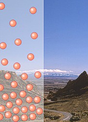 In the United States, pressure is commonly expressed in millibars (mb) or inches of mercury (Hg). Meteorologists use millibars (the unit shown on weather maps), while aviation and television weather reports use inches of mercury. Atmospheric pressure is measured with a barometer, which is why it is sometimes called barometric pressure. The average sea level pressure is 1013.25 mb or 29.92 Hg. 1 millibar (mb) = 0.02953 inches of mercury (Hg).
Temperature is a measure of the degree of hotness or coldness of an object. It is actually a measure of the average kinetic energy or speed of the molecules in a substance (air). The more kinetic energy (speed) the molecules have, the higher their temperature and vice versa. Air temperature is measured with a thermometer and is expressed using the Kelvin scale, Fahrenheit scale (°F) or the Celsius scale (°C). The Kelvin scale is convenient for scientific calculations, but is not used to report the air temperature. In most of the world, air temperature is expressed in °C, but in the United States, only temperatures above the surface are expressed in °C. Temperatures at the surface are usually expressed in °F. °C = 5/9(°F-32). K = °C + 273. Temperature is used to define the layers of the atmosphere. 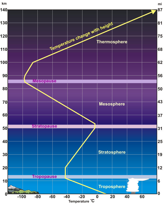 The layer closest to the earth's surface is the troposphere and it is a very important layer to meteorologists because it is the layer that contains all of our weather. Sunlight warms the earth's surface and then the surface warms the air above it. As one moves away from the earth's surface (the heat source), the air becomes cooler. This is why temperature usually decreases with height in the troposphere. Sometimes the air temperature may increase with height in a narrow layer. This is referred to as a temperature inversion. Air temperature may also stay the same with increasing height. This is called an isothermal layer. At about the altitude where jet aircraft fly (˜30,000 ft), the air temperature becomes isothermal. The bottom of this isothermal layer marks the end of the troposphere and the beginning of the stratosphere. The boundary separating the troposphere from the stratosphere is called the tropopause. The air temperature begins to increase with increasing height (temperature inversion) in the stratosphere. The reason for this warming is that ozone in the stratosphere absorbs ultraviolet (UV) radiation. The ozone also protects life on earth from this dangerous radiation. Above the stratosphere is the mesosphere, where air temperature again decreases with height. The boundary separating these two layers is called the stratopause. The air temperature decreases with height because there is little ozone at those altitudes to absorb the UV radiation. The final layer is the thermosphere, which is separated from the mesosphere by a boundary called the mesopause. Air temperature increases again in this layer, due to the absorption of solar radiation by oxygen molecules.
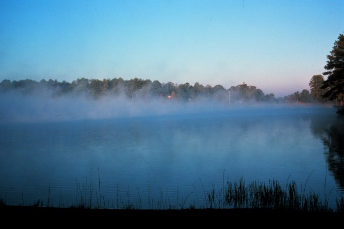
Dewpoint temperature is a measure of the moisture content in the atmosphere and is the temperature to which air must be cooled (at constant pressure, with no change in water vapor content) for saturation to occur. When saturation is reached, condensation occurs and such things as dew, frost or fog may occur. The dewpoint temperature is a good indicator of the actual amount of water vapor in the air. High dewpoint temperatures indicate there is high water vapor content, which indicates the air is moist. Low dewpoint temperatures indicate there is low water vapor content, which indicates the air is dry.
The source of heat for our planet is the sun. The sun's energy moves through space, then through the earth's atmosphere and finally reaches the earth's surface. The sun's radiation warms the earth's atmosphere and surface and becomes heat energy. This heat energy is transferred through the atmosphere by one of three mechanisms:
This type of heat transfer can be observed on sunny days. You face will feel warm when you are standing in the sun. The sunlight is absorbed by your face and warms you face, without warming the air around you. The energy from the sun that is absorbed by your face is called radiant energy or radiation. Radiation is the transfer of this heat energy by electromagnetic waves.  Most of the electromagnetic radiation from the sun is in the form of visible light. Light is made up of waves of different frequencies. These frequencies are interpreted by our brain as colors. Infrared waves and ultraviolet waves are two types of waves from the sun that we cannot see. Solar radiation mostly passes through the atmosphere and is absorbed by all objects, such as humans, trees, flowers, roads, etc. These objects will then warm up. Dark objects, such as asphalt roads, will absorb and warm faster than light colored objects, which reflect the radiation back to space.. All substances emit radiation, but this emitted radiation will be at a longer wavelength that our eyes cannot see. This emitted radiation, called infrared radiation, can be absorbed by the atmosphere. A substance's temperature will determine which wavelength of radiation the substance will emit and also the rate of emission. The higher the substance's temperature, the shorter the wavelength of the emitted radiation (think of how a burner on an electric stove turns from black to red as it heats up). Also, the higher the substance's temperature, the greater the emission rate of radiation.
Conduction is the transfer of heat from one molecule to another within a substance. Remember that temperature is just the measure of the average kinetic energy or speed of the molecules in a substance. Imagine you are holding a metal pin between your fingers and you place this pin in a flame. The pin absorbs the energy from the flame and the molecules inside the pin begin to move faster (warmer temperature). These faster moving molecules cause adjoining molecules to move faster and will eventually cause the molecules in your fingers to move faster. The heat is now being transferred from the pin to your finger and your finger will heat up. This is an example of heat transfer through conduction. When heat is transferred through conduction, it flows from warmer to colder regions and will transfer more rapidly with greater temperature differences. The rate of heat transfer through conduction also depends on whether the substance is a good conductor. It turns out that air is an extremely poor conductor of heat. Therefore, conduction is only important in the atmosphere within the first several millimeters closest to the surface. How then does the air transfer energy from one region to another?
Convection is the transfer of heat through the movement of a fluid, such as water or air. This type of heat transfer can occur in liquids and gases because they move freely, making it possible to set up warm or cold currents. Convection occurs naturally in the atmosphere on a warm, sunny day. As the earth's surface absorbs sunlight, certain portions of the surface absorb more than other portions. The earth's surface and the air near the surface heats unevenly. The warmest air expands, becomes less dense than the surrounding cooler air, becomes buoyant and rises. These rising "bubbles" of warm air, called thermals, act to transfer heat up into the atmosphere. Cooler, heavier air then flows toward the surface to replace the warm air that just rose. When the cooler air reaches the surface, it is warmed and it too eventually rises as a thermal. This circulation is referred to as a convective circulation or thermal cell. These "bubbles" or thermals can result in cloud formation, which will be discussed more in the "Weather" section.  Convection transfers heat vertically into the atmosphere. In order for heat to be transferred to other regions, it must be transferred horizontally by the wind. The horizontal transfer of heat by the wind is called advection.
The water cycle, also known as the hydrologic cycle, refers to the continuous movement of water between the earth and the atmosphere. There are many components to the water cycle, but only the most important ones will be discussed here:
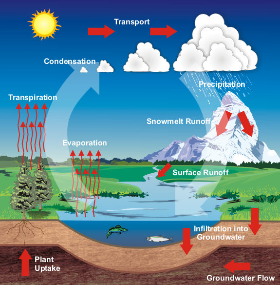 Evaporation is the process by which a substance changes from the liquid phase to the gas phase. On earth, the most important substance is water (liquid water into water vapor). Energy is required for evaporation to occur. Energy can come from the sun (radiation), the atmosphere (conduction) or the earth (conduction). When energy is extracted from the atmosphere to evaporate liquid water, the atmosphere will cool. This is also true if water evaporates off a surface. An example is when you step out of a pool on a warm, sunny day. The water on your skin will evaporate, removing heat from your skin, causing your skin to cool. Evaporation is very important because it is how water vapor, which is needed for clouds and precipitation, enters the atmosphere. Transpiration is simply the evaporation of water through plant membranes. It is another important way in which water vapor enters the atmosphere.
Condensation is the process by which a substance changes from the gas phase to the liquid phase. As air containing water vapor rises into the atmosphere, it will expand and cool. If it cools to its dewpoint temperature, the air will become saturated and condensation will occur. Condensation can be observed in the atmosphere as clouds, fog, dew, or frost form. When condensation occurs, the heat required to originally evaporate the water is returned to the atmosphere, causing the atmosphere to warm.
Clouds are composed of millions of water droplets that have condensed. These water droplets grow into larger droplets by colliding and coalescing with one another. Eventually, the droplets can grow large enough that they will not be able to stay suspended in the cloud. When this occurs, they fall out of the cloud as precipitation. If the cloud's temperature is below freezing, it will contain ice crystals. Ice crystals collide and stick to other ice crystals and eventually fall from the cloud as snow. Precipitation is water, either liquid or solid, that falls from the atmosphere to the surface.
Runoff and groundwater are both driven by precipitation. When precipitation falls to the surface, it will either be absorbed into the ground (groundwater) or, if the ground cannot absorb any more water, flow into streams. Eventually, even water that is absorbed into the ground will make its way into streams. The water in streams converges into rivers and flows back to the oceans. Finally, some of the runoff will be evaporated and some of the groundwater will be taken in by plants and then transpired.
Wind is simply air in motion relative to the earth's surface. We normally think of the wind as the horizontal motion of the air, although air actually moves in three dimensions. The vertical component of the wind is generally quite small, except in thunderstorm updrafts. The vertical motion of air, however, is very important in determining our weather. Air that is rising cools, which may cause it to reach saturation and form clouds and precipitation. Conversely, air that is sinking warms, which causes clouds to evaporate and produce clear weather. Why does the wind blow? There are three forces that cause the wind to blow in the direction that it does.
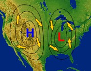 |
Surface maps usually have H's and L's at various locations. The H's and L's represent high and low pressure systems. On weather maps highs and lows are surrounded by lines called isobars. Isobars are lines of constant pressure; they connect every location that has the same value of pressure. When isobars are packed close together, the pressure is changing rapidly over a small distance. The closer the isobars are packed together, the stronger the pressure gradient (the rate of pressure change over a given distance.) Also, notice that (in the Northern Hemisphere) the wind blows clockwise around a high pressure system and also slightly outward from its center. Around a low pressure system, the wind blows counterclockwise and slightly in towards its center. |
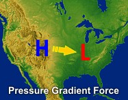 |
The Pressure Gradient Force (PGF) arises due to differences in pressure within the atmosphere. In a physical sense, this force is trying to move air to eliminate pressure differences. The PGF causes air to flow from high pressure to low pressure. In the absence of any other forces, wind would blow directly from high to low pressure. The PGF also affects the speed of the wind. As the PGF becomes stronger (i.e. pressure changing rapidly with distance), the wind speed increases. When looking on a surface map, strong winds would occur in locations where the isobars are packed close together (strong PGF). |
 |
A complicated force that affects the wind is the Coriolis Force. The Coriolis Force is due to the earth's rotation. This force causes moving objects (i.e. air, planes, birds, etc) to deflect to the right of their motion in the Northern Hemisphere and to the left in the Southern Hemisphere. The Coriolis Force is strongest near the poles and zero at the equator. In most of the atmosphere, it is nearly equal and opposite the PGF. If the PGF and the Coriolis Force are exactly equal and opposite, the wind would blow parallel to isobars, with high pressure on the right. |
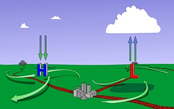 |
The third force acting on the wind is friction. Friction becomes very important near the earth's surface because the surface of the earth is rough. Friction is the force that causes air to slow down and spiral into lows and out of highs. When air spirals into the low, it is converging into the low. When air converges near the surface, it is forced to rise. As air rises, it may condense and form clouds and precipitation. This is why low pressure systems are often associated with adverse weather conditions. Conversely, high pressure systems are generally associated with fair weather. When air spirals out of the high, it is actually diverging. As air diverges from the high, the air above the surface must sink in order to replace the air that is moving away from the high. Sinking air warms and tends to evaporate any clouds that may be present. |
Clouds typically form when air rises. The reduction in pressure as air rises causes the air to expand and cool. Rising motion can be associated with convection in unstable air, lifting of air over topography (mountains), or lifting of air by fronts. (Fronts will be discussed in more detail in the next section.) When air rises, the air's temperature cools and may reach its dewpoint temperature, at which point it becomes saturated. Once saturation is reached, condensation occurs and the water vapor in the air will condense into tiny water droplets. As millions of droplets form, a cloud will begin to take shape. 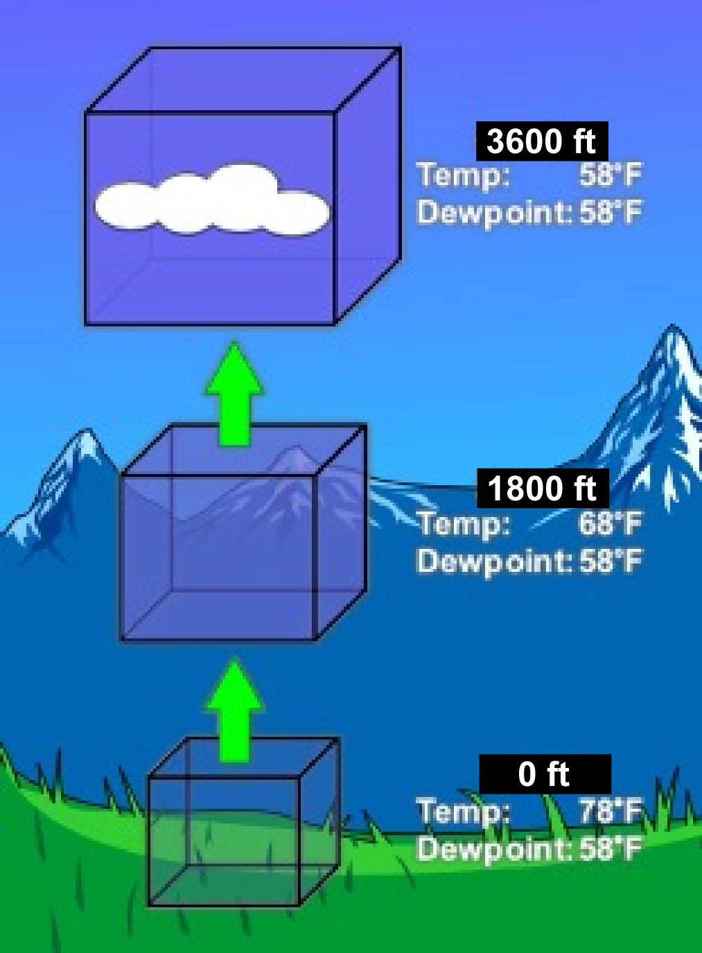
Clouds are classified by their height (high, middle, low, or vertically developing), physical appearance and whether they produce precipitation. Here are a few Latin roots that are helpful when identifying cloud types:
"cirro": high, 'curl of hair'
"alto": 'middle'
"stratus": layer, sheet-like, low
"cumulus": heap-like, puffy
"nimbus": clouds producing precipitation
Combinations of these Latin roots are used to describe the most common types of clouds (i.e. a cirrostratus cloud is one that is high and layered).
 |
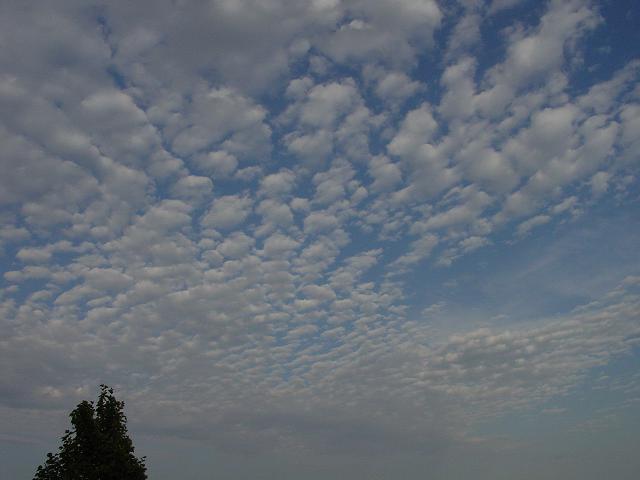
High level clouds form above 20,000 feet (6000 meters). Since they form high in the atmosphere, high clouds are composed of ice crystals, due to the cold temperatures in this part of the atmosphere. High-level clouds are typically thin and white in appearance, but may display an array of colors when the sun is low on the horizon. |
 |
Mid-level clouds typically have bases between 6,500 to 20,000 feet (2000 to 6000 meters). Since these clouds are located lower in the atmosphere, they are primarily composed of water droplets. In the cold season, they can be composed of ice crystals since the temperatures are cold enough. |
 |
Low clouds typically have bases below 6,500 feet (2000 meters). These clouds are located low in the atmosphere and are mostly composed of water droplets. On occasion, if the temperatures are cold enough, they may contain some ice particles and snow. |
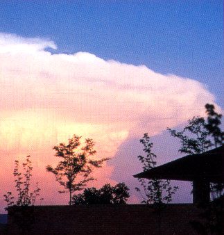 |
Some clouds can span the depth of the troposphere and therefore cannot be classified as high, middle or low. These clouds are classified as vertically developing. Cumulus clouds are characterized by a flat base and can grow to heights exceeding 39,000 feet (12,000 meters). They can contain both liquid droplets and ice particles because they cover a large depth of the troposphere. With the right conditions, these are the clouds that become powerful thunderstorms. |
An air mass is a large body of air that has relatively uniform temperature and humidity characteristics. The regions where air masses form are referred to as air mass source regions. If air remains over a source region long enough, it will acquire the properties of the surface below. Ideal source regions are regions that are generally flat and of uniform composition. Examples include central Canada, Siberia, the northern and southern oceans and large deserts. 
Air masses are classified according to their temperature and moisture characteristics. They are grouped into four categories based on their source region. Air masses that originate in the cold, polar regions are designated with a capital "P" for polar. Air masses that originate in the warm, tropical regions are designated with a capital "T" for tropical. Air masses that originate over land will be dry and are designated with a lowercase "c" for continental. Air masses that originate over water will be moist and are designated with a lowercase "m" for maritime. These letters are combined to indicate the type of air mass:
cP: cold, dry air mass
mP: cold, moist air mass
cT: warm, dry air mass
mT: warm, moist air mass
In winter, one more type of air mass may form, an extremely cold, dry air mass referred to as cA, continental arctic. Once formed, air masses can move out of their source regions bringing cold, warm, wet, or dry conditions to other parts of the world.
|
A front is simply the boundary between two air masses. Fronts are classified by which type of air mass (cold or warm) is replacing the other. |
 |
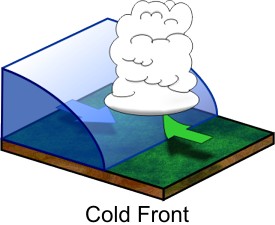 |
A front is called a cold front if the cold air mass is replacing the warm air mass. The air behind a cold front is colder and typically drier than the air ahead of it, which is generally warm and moist. There is typically a shift in wind direction as the front passes, along with a change in pressure tendency (pressure falls prior to the front arriving and rises after it passes). Cold fronts have a steep slope, which causes air to be forced upward along its leading edge. This is why there is sometimes a band of showers and/or thunderstorms that line up along the leading edge of the cold front. Cold fronts are represented on a weather map by a solid blue line with triangles pointing in the direction of its movement. |
|
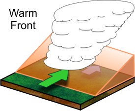
A warm front occurs when a cold air mass is receding (i.e. a warm air mass is replacing a cold air mass). The air behind a warm front is warm and moist, while the air ahead of a warm front is cooler and less moist. Similar to the cold front, there will a shift in wind direction as the front passes and a change in pressure tendency. Warm fronts have a more gentle slope than cold fronts, which often leads to a gradual rise of air. This gradual rise of air favors the development of widespread, continuous precipitation, which often occurs along and ahead of the front. Warm fronts are represented on a weather map by a solid red line with semi-circles pointing in the direction of its movement. |
 |
A stationary front is a front that is not moving. Although the frontal boundary does not move, the air masses may move parallel to the boundary. Stationary fronts can also produce significant weather and are often tied to flooding events. Stationary fronts are represented on a weather map by alternating red and blue lines, with blue triangles and red semi-circles facing opposite directions.
Generally, cold fronts move faster than warm fronts. Sometimes in a storm system the cold front will "catch up" to the warm front. An occluded front forms as the cold air behind the cold front meets the cold air ahead of the warm front. Which ever air mass is the coldest undercuts the other. The boundary between the two cold air masses is called an occluded front. Occluded fronts are represented on weather maps by a solid purple line with alternating triangles and semi-circles, pointing in the direction of its movement.
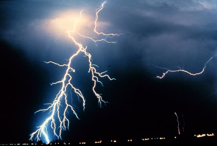
Thunderstorms are cumulonimbus clouds that produce thunder and lightning. The figure below shows the average number of days that thunderstorms occur over the United States. The greatest occurrence of thunderstorms occur in the southeastern United States, with a secondary maximum over the Colorado Rockies. These regions frequently have all the necessary conditions for thunderstorm formation. 
In order for a thunderstorm to form, three "ingredients" must be present:
1. Moisture
2. Instability
3. A Lifting Mechanism
Moisture is very important in thunderstorm formation because it "fuels" the thunderstorm. Typical moisture sources are large bodies of water, such as the Gulf of Mexico, Atlantic Ocean or Pacific Ocean. The southeastern United States can tap into moisture from two of these sources (Gulf of Mexico and Atlantic Ocean). This is one reason why this region has the greatest frequency of thunderstorms in the United States. 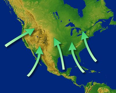
Air is said to be unstable if it continues to rise after being given a slight "push" upward. Conversely, air is considered to be stable if it returns to its original position after being "pushed" upward. In order for thunderstorms to develop, air needs to be unstable. Air is most likely to be unstable when warm, moist air is present at the surface and cold, dry air is present aloft. 
Another ingredient that must be present is a lifting mechanism to give the air the initial "push" upward. There are several ways in which air can be lifted. Lifting primarily occurs along fronts (cold, warm, stationary, or occluded fronts). Air can also be lifted as it flows over hills or mountains. Locations where these three"ingredients" come together are most likely to experience a thunderstorm.
Many non-severe thunderstorms go through a life cycle consisting of three distinct stages. This life cycle generally lasts one to two hours.
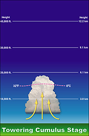 |
The first stage is the towering cumulus stage, or growth stage. The warm, moist air rises and cools, eventually condensing into a cumulus cloud. As condensation occurs, it warms the air (remember, condensation is a warming process), keeping the air inside the cloud warmer than the air around it. This keeps the air unstable and allows the cloud to keep growing vertically. During this stage, updrafts keep the water droplets and ice crystals suspended in the cloud. There is no precipitation, and generally no lightning, or thunder during this stage. As the cloud builds to altitudes where the temperature is below freezing, large raindrops and even small hail begin to form. Eventually, the raindrops and small hail become heavy enough that the updraft cannot keep them suspended in the cloud and they begin to fall as precipitation. These falling particles, and evaporation and cooling of air near the cloud boundaries, creates a downdraft, which signifies the beginning of the next stage. |
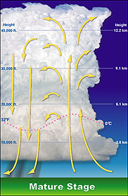 |
The appearance of downdrafts marks the beginning of the mature stage. During this stage, updrafts and a downdrafts are present and the thunderstorm is at its most intense state. The cloud grows so high, that it reaches a stable part of the atmosphere (possibly the stratosphere) and cannot grow any higher. The top of the cloud spreads out and forms an anvil shape. Lightning, thunder, heavy rain and possibly small hail are produced during this stage. Sometime after the storm enters its mature stage, it eventually begins to dissipate. This signifies the beginning of the next stage. |
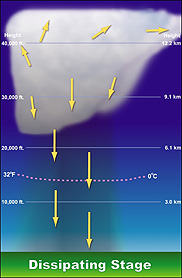 |
During this final stage, the updrafts weaken and the downdrafts dominate the thunderstorm. The thunderstorm usually does not last much longer after this occurs because the updrafts were providing the thunderstorm with their "fuel", the warm, moist air from the surface. Without the warm, moist air, cloud droplets stop growing and only some light precipitation remains. Many times, the lower portion of the cloud evaporates and the only thing left of the thunderstorm is the anvil. |
A tornado is a violently rotating column of air that originates within a thunderstorm and is in contact with the ground. Tornadoes often only last a few minutes, but it is possible for tornadoes to last over an hour and travel many miles. Around 1,000 tornadoes occur in the United States each year. More tornadoes strike the central United States than any other place in the world, so this region has earned the nickname "tornado alley." The peak of tornado season occurs between April and June. Tornadoes typically form in association with supercell thunderstorms. A supercell thunderstorm is a special type of thunderstorm that can persist for several hours due to its organized internal structure. Supercell thunderstorms are characterized by a single, rotating updraft. They form in regions of strong vertical wind shear. Vertical wind shear is the change in wind speed and/or direction with height. Directional wind shear refers to the change of wind direction with height and speed shear, the change of wind speed with height. Vertical wind shear induces a "rolling" effect in the atmosphere, similar to the diagram below. This rolling effect becomes important when a thunderstorm forms because it is tilted upward and causes a thunderstorm to rotate.
 |
 |
|
Directional Wind Shear |
Speed Shear |
 |
In the diagram to the left, a rotating column of air, which was produced by the speed shear, is lifted vertically by the updraft of a developing thunderstorm. This initially induces two different rotations within the supercell; a cyclonic (counter-clockwise) rotation and an anti-cyclonic (clockwise) rotation. Directional wind shear amplifies the cyclonic rotation (left side of image) and diminishes the anticyclonic rotation (right side of image). Once this occurs, only the cyclonic rotation remains. The rotating updraft of a supercell is referred to as a mesocyclone. |
|
Due to the counterclockwise rotation of the mesocyclone, supercells often take on a "hook" appearance when viewed on radar. This is because the rain produced by the thunderstorm is wrapped around the rotating updraft. The figure to the right is a schematic of the precipitation associated with a supercell and the area encircled in red is the location of the rotating updraft. The center of the rotating updraft is near the point where a tornado is likely to form. |
 |
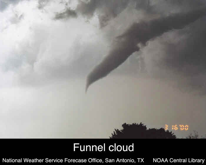
The term "funnel cloud" is used to describe a region of strong rotation where the circulation has not reached the ground yet. The funnel becomes visible when water vapor begins to condense into liquid droplets. One sign that the circulation has reached the ground and has become a tornado is that dust and debris on the ground will begin to rotate. The size and/or shape of the tornado is not always a measure of its strength, although very large tornadoes are almost always quite destructive. Tornadoes will gradually lose strength and take on a rope-like appearance.
 |
 |
 |
|
Funnel Cloud |
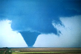
Tornado |
Dissipating Tornado |
Tornadoes are classified according to the damage they cause, which is related to their wind speed. The original scale, called the Fujita (F) Scale, was developed by Dr. Fujita in the 1960s. A tornado's wind speeds are estimated based on the damage caused by the storm, which is assessed after-the-fact. There are some apparent problems with the F-Scale. One problem is that it is subjective. A different assessment may be made based on who is assessing the damage. Another problem is the structural integrity of buildings may vary. One last problem is that the damage assessment is completed after-the-fact. This can be a problem because the damage site might be altered before it is assessed. Due to these potential problems with the Fujita Scale, a new scale, the Enhanced Fujita (EF) Scale was implemented on February 1, 2007. This new scale uses Degree of Damage Indicators, in order to get a more realistic estimate of a tornado's winds.
| Scale | Category | Wind Speed | Possible Damage |
| EF-0 | Weak | 65-85 mph | Light: tree branches broken, sign boards damaged |
| EF-1 | Weak | 86-110 mph | Moderate: trees snapped, mobile homes pushed off foundations or overturned, windows broken |
| EF-2 | Strong | 111-135 mph | Significant: large trees snapped or uprooted, weak structures destroyed |
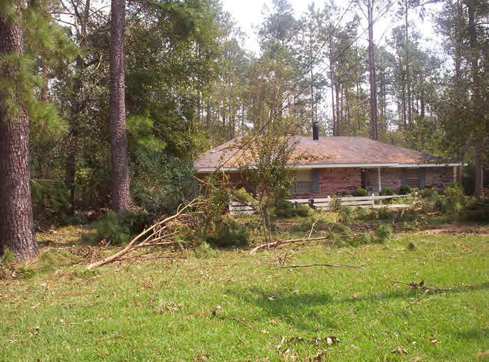
| EF-3 | Strong | 136-165 mph | Severe: some roofs torn off framed houses, trees leveled |
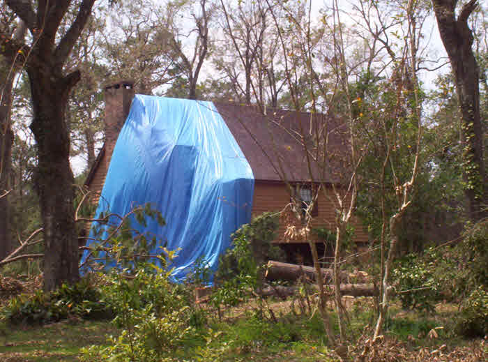
| EF-4 | Violent | 166-200 mph | Devastating: roofs and some walls torn off well constructed houses, car thrown or overturned |
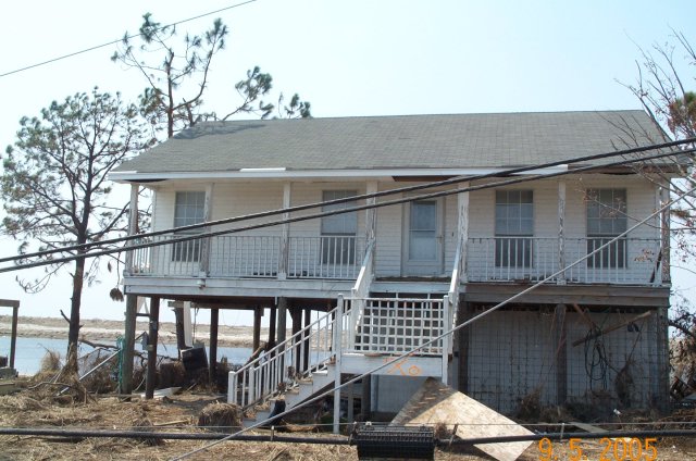
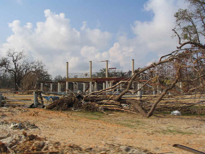
| EF-5 | Violent | >200 mph | Incredible: houses may be lifted off foundation, structures the size of automobiles can be thrown over 100 meters, steel-reinforced buildings highly damaged |
|
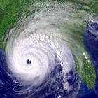
Hurricanes are tropical cyclones that have an organized circulation, with sustained winds exceeding 74 mph. Hurricanes develop over tropical waters. Tropical cyclones forming in the Atlantic and Eastern Pacific are called hurricanes, while in the Western Pacific they are called typhoons, and in the Indian Ocean they are called cyclones. |
 |
An organized system of clouds and thunderstorms in the tropics with a defined circulation, and maximum sustained winds of 38 mph or less is called a "tropical depression". Once a tropical depression has sustained winds of at least 39 mph, it is called a "tropical storm." This is when a tropical cyclone is assigned a name. A tropical storm becomes a hurricane when it reaches maximum sustained winds of 74 mph. Hurricanes are classified by their wind speeds using the Saffir-Simpson Scale.
| Category | Wind Speed | Damage |
| 1 | 74-95 mph | Damage mainly to unanchored mobile homes, shrubbery, and trees. |
| 2 | 96-110 mph | Some damage to roofs of buildings, considerable damage to shrubbery and trees, with some trees blown down and major damage to mobile homes. |
| 3 | 111-130 mph | Some structural damage to small residences, mobile homes destroyed, foliage blown off trees and large trees blown down. |
| 4 | 131-155 mph | Extensive damage to doors, windows and roofs, shrubs, trees and all signs blown down, and complete destruction of mobile homes. |
| 5 | >155 mph | Severe window and door damage, extensive roof damage to residences and industrial buildings, some complete building failures with small buildings blown over or away. |
 |
 |
 |
 |
 |
| Category 1 | Category 2 | Category 3 | Category 4 | Category 5 |
The main parts of a tropical cyclone are the eye, the eyewall, and the rainbands. Air near the surface spirals in towards the center and rotates counterclockwise around the storm center in the northern hemisphere (clockwise in the southern hemisphere). The air rises in the eyewall, and in the spiral rainbands. The air then moves out at the top of the cyclone in the opposite direction. 
|
The eye is located in the center of the storm (see satellite image to the right) and is a region of generally clear skies and light winds. The size of the eye is typically 20-40 miles across, but can be larger or smaller depending on the storm. The skies are generally clear in the eye because the air is sinking in this region of the hurricane. This sinking air actually suppresses cloud formation. At the ground, the transition from the very strong winds under the eyewall to the near calm conditions in the eye can be deceiving. Some people think the storm is over when the eye is passing over, when in fact it is only half over and the dangerous winds on the other side of the eye are still to come. |
 |
|
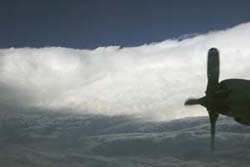
The eyewall is a wall of deep clouds (see photo to the right) that produce the torrential rainfall that surrounds the eye of hurricanes. The strongest winds are found under the eyewall. The eyewall goes through periods where it will shrink in size and sometimes a double (concentric) eyewall will form. When the eyewall and/or the eye are going through changes in their structure, there will be associated changes in the surface wind speed. Therefore, these structural changes are a good indication of changes in the storm's intensity. |
 |
|
The clouds and thunderstorms that swirl in toward the storm's center are called spiral rainbands (see radar image to the right). Spiral rainbands can produce heavy downpours and wind, as well as tornadoes. |
 |
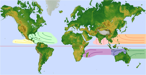
Since hurricanes need warm waters for development, they only form over warm, tropical oceans. They rarely form within 5° latitude of the equator, because the Coriolis Force is weak near the equator and the thunderstorm clusters will not rotate. (The Coriolis Force is zero at the equator and increases towards the poles.) There are seven regions around the world where tropical cyclones form:
The following environmental conditions must be present for a tropical cyclone to develop:
 |
|
 |
When a cluster of thunderstorms develops or moves into environment described above, the disturbance can become more organized, which leads to the formation of a tropical depression. The warm water is one of the most important contributors to tropical cyclone formation because it acts as the "fuel" for the storm. As water vapor rises, it cools and once saturation is reached, the water vapor condenses into liquid water that we see as clouds. During the process of condensation, heat is released. This warms the atmosphere, making the air lighter and causing it to rise further. As this occurs, more air must move in near the surface to take its place. This inflowing air will begin to rotate under the influence of the Coriolis Force. As the pressure drops in the center of the storm, signifying strengthening, the pressure gradient becomes stronger. The pressure gradient is directly related to wind speed and the stronger the pressure gradient, the faster the wind speed. |
Both weather and climate tend to be quite variable, with short and long time scale variations. Long time scale variations are generally associated with changes in atmospheric circulations, which lead to changes in weather, temperature and rainfall patterns around the world. One of these naturally occurring circulations is the El Niño/Southern Oscillation (ENSO) cycle. This occurs in the tropical Pacific Ocean near the equator when there is a reversal of the surface air pressure at opposite ends of the Pacific Ocean.
Normally the trade winds in this region blow towards the west from a region of higher pressure in the eastern Pacific to a region of lower pressure in the western Pacific. These winds enhance upwelling (the rising of cold water from the deep ocean towards the surface) in the eastern Pacific off the coast of South America. Therefore, sea surface temperatures, as seen on the figure below, are cool off the coast of South America and significantly warmer in the western Pacific.
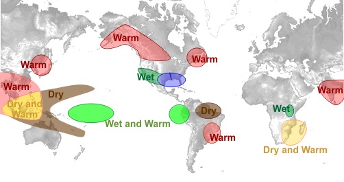
Every few years, this pressure pattern breaks down, resulting in higher pressure in the western Pacific and lower pressure in the eastern Pacific. This causes the winds to slow or even blow towards the east instead of towards the west. This wind reversal brings the warmer water from the western Pacific towards South America. This warming of the ocean is El Niño. This large area of warmer ocean temperatures can have an effect on the global wind patterns, which in turn affects the temperature and rainfall patterns around the world. The following graphics show the effects that a strong El Niño pattern can have globally.
 |
 |
| El Niño effect during December through February | El Niño effect during June through August |
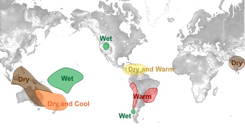
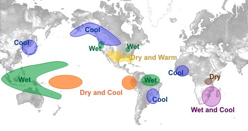
Eventually the El Niño event will begin to subside and the pressure and wind patterns will return to normal. Sometimes, the trade winds, which are blowing towards the west, can be very strong. This strong flow causes the cold surface water in the eastern Pacific to move out over the central Pacific. This cooling of the central and eastern Pacific Ocean is La Niña.  This pattern can also have an effect on the global wind patterns and thus the temperature and rainfall patterns throughout the world. Generally, the impacts of La Niña tend to be opposite those of El Niño. The following graphics show the effects a strong La Niña pattern can have globally.
 |
 |
| La Niña effect during December through February | La Niña effect during June through August |
Atmospheric greenhouse gases (water vapor, carbon dioxide, methane, and other gases) trap some of the earth's outgoing (infrared) energy, which causes the atmosphere to retain this heat and warm. Life as we know it today would not be possible if it were not for this natural "greenhouse effect". Without the greenhouse effect, temperatures would be much lower than they are today because the energy (heat) would simply escape to space. However, if the atmospheric concentration of greenhouse gases increases, problems may arise.

Since the beginning of the industrial revolution, the atmospheric concentration of certain greenhouse gases has increased. The atmospheric concentration of carbon dioxide, one of the most talked about greenhouse gases, has increased by nearly 30%. Other greenhouse gases have also experienced increases in their concentrations. These increases have enhanced the greenhouse effect (i.e. heat-trapping capability) of the earth's atmosphere.
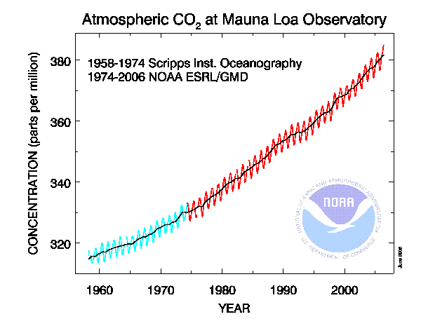
Scientists generally agree that the increase in the concentration of carbon dioxide is primarily due to the combustion of fossil fuels and other human activities. Another source of carbon dioxide in the atmosphere is from plant respiration and the decomposition of organic matter. Before the industrial revolution all of these carbon dioxide sources were generally in balance with the removal of carbon dioxide through absorption by the oceans and vegetation. As a result, there was no net increase in carbon dioxide concentrations. Human activities (i.e. fossil fuels burned to power car and trucks, heat homes, etc.) have yielded an additional release of carbon dioxide into the atmosphere, increasing its concentration. The rate of climate change, particularly global warming, is likely to accelerate due to the increasing concentrations of greenhouse gases. Since the late 19th century, the global mean surface temperatures have increased 0.5-1.0°F.


 Follow us on YouTube