Tropical Storm Cindy, the third named storm of the 2017 Atlantic hurricane season, made landfall in Louisiana on June 22nd. Cindy quickly weakened to a Tropical Depression as it curved northeastward through Arkansas, and then transitioned to a Post-Tropical Cyclone as it traveled eastward across Kentucky. Despite the transition, the system left a path of flooding, wind damage and even a few tornadoes across the Bluegrass State during the afternoon and evening hours of June 23rd.
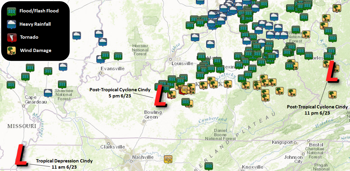 |
| NWS Local Storm Reports received from June 23rd into the early morning hours of June 24th as the remnants of Tropical Storm Cindy moved across the region. |
As Cindy's circulation tracked eastward across central Kentucky, a band of intense rainfall developed to the north, stretching from Elizabethtown east-northeastward through Lexington and into northeast Kentucky. This intense band of rain, with rainfall rates of over 4" per hour at times, aligned for a time west to east along interstate 64.
[755 pm] Rainfall rates of over 4" per hour are occurring in heavy rain band along I-64. Watch for flash flooding to develop. #kywx pic.twitter.com/fh7sgUZBPF
— NWS Jackson KY (@nwsjacksonky) June 23, 2017
Flash flooding developed quickly under this band of heavy rain, with road closures reported through much of Montgomery, Bath, Fleming and Rowan Counties during the late evening hours. Despite the fact that the system moved quickly to the east, limiting the duration of heavy rainfall to 3 to 6 hours, rainfall amounts of 2 to 3" were common in these areas.
Here's a look at some rainfall reports from the counties hardest hit by flooding this evening. #kywx pic.twitter.com/v8k0M5bQRl
— NWS Jackson KY (@nwsjacksonky) June 24, 2017
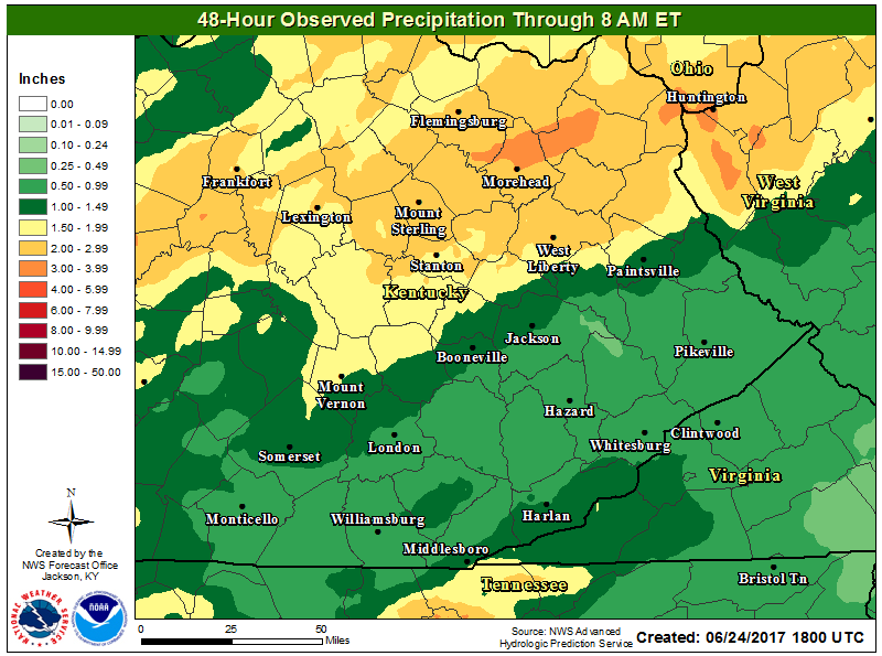 |
| Storm total rainfall amounts as the remnants of Tropical Storm Cindy tracked across eastern Kentucky. |
Farther to the south, strong winds occurred along Cindy's path from Larue County in central Kentucky eastward to near Pikeville. Survey teams from National Weather Service Louisville confirmed two tornado touchdowns along with the wind damage that occurred between Hodgenville and Lebanon. Farther to the east, the Mountain Parkway was blocked by fallen trees near Helechewa at one point, and a tree fell on a car on Whitestone Road in Wolfe County. Additional roads were blocked for a period of time during the evening by fallen trees in Breathitt, Morgan, Magoffin and Floyd Counties. Shortly before midnight, Kentucky Power reported over 7,500 customers were without power due to the storm in their service area.
@nwsjacksonky GRANDVIEW DR IN COMMUNITY OF TRAM IN FLOYD COUNTY pic.twitter.com/sDFl9zjlO8
— Richard Trim (@RichardTrim2017) June 24, 2017


Cindy's rains followed heavy rains which fell in a more scattered nature on June 18th. Rowan and Fleming Counties were targetted by heavy rains during both events. The Morehead Regional Airport recorded 8.42" of rain during the week of June 18th through the 24th. According to the NOAA Atlas 14 Point Precipitation Frequency Estimates, the average return interval for that amount of rain in that area is between 50 and 100 years. In other words, based on climatology, there's only a 1 to 2% chance of getting that much rain in a week in any given year.
Morehead Airport has received 8.42" of rain over the past week. Average recurrence interval for that amount is between 50 & 100 years! #kywx pic.twitter.com/u4yEqic1jg
— NWS Jackson KY (@nwsjacksonky) June 25, 2017
Now that Cindy has passed, a much drier and cooler weather pattern is expected across eastern Kentucky lasting well into the new work week. This will provide the area an opportunity to dry off and clean up.

