|
Record-Breaking 2020 Atlantic Hurricane Season Produced 30 Named Storms, 2020 was the Warmest Year in Recorded History in Myrtle Beach, Second Wettest Year on Record in Florence and Lumberton |
January
Temperatures during January ran 6 to 8 degrees warmer than normal, making this the warmest January since 1990. In Florence, SC only four nights with freezing temperatures occurred all month, the third lowest total since records began there in 1948. A streak of particularly warm weather occurred January 10 through 16 when seven straight days of high temperatures in the 70s occurred. Overnight lows in the 60s on January 10 through 15 were around 30 degrees above normal.
During the middle of this warm period a front stalled across central North and South Carolina, helping to develop waves of showers and thunderstorms. One thunderstorm during the afternoon of January 13 produced a tornado in Loris, SC that damaged a number of cars in the Loris High School parking lot. Half a dozen pine trees were snapped off, and a barn near Highway 9 was damaged. An NWS storm survey found evidence for wind speeds up to 90 mph during this tornado along its 1.2 mile path, making it an EF1 on the Enhanced Fujita scale. There were no injuries or fatalities reported.
|
Security camera video from Loris High School shows the tornado moving from left to right across the parking lot, damaging several vehicles. Winds reached 90 mph, making this an EF1 tornado. |
Significant rainfall also occurred on January 13 with one to two inch totals recorded in Darlington, Bennettsville, Whiteville, and Turnbull Creek Forest near Elizabethtown. Drier than normal weather along the coast in January prompted the USDA to classify portions of coastal North and South Carolina as "abnormally dry" as rainfall was 1 to 2 inches below normal.
February
Above-normal temperatures continued through February with cities across the eastern Carolinas running 4 to 5 degrees warmer than normal. The most substantial rainfall of the month occurred on February 6 and 7 as heavy rain and thunderstorms developed ahead of a cold front. Florence and Wilmington each set new daily records on February 6 with 2.69 and 2.06 inches of rain, respectively. Severe thunderstorms also accompanied this system with wind damage reported across Myrtle Beach, Longwood, Southport, and Wilmington. The North Myrtle Beach airport recorded a wind gust to 61 mph, the strongest of the year.
The first 80 degree temperatures of 2020 occurred in Florence and Lumberton on February 13, however much colder weather developed behind an arctic cold front February 20. The only frozen precipitation of the entire winter occurred on February 20-21 as low pressure off the Florida east coast threw moisture back over the cold air behind the front. Sleet and snow accumulated to a couple tenths of an inch across Robeson and Bladen counties with trace amounts reported across parts of northeastern South Carolina and down to the North Carolina coast. Heavier snowfall amounts over 4 inches fell north of Raleigh.
|
Automated regional snow depth analysis on February 21, 2020 from the NWS National Operational Hydrologic Remote Sensing Center (NOHRSC) |
More on this event from the NC Climate Office.
Daytime highs only in the 30s and lower 40s on February 21 were followed by low temperatures the morning of Feburary 22 in the lower 20s. Wilmington, Lumberton and Florence all reached 23 degrees, their coldest readings of the 2019-2020 winter. Temperatures in Darlington, SC bottomed out at 20.
March
Above-normal temperatures continued through March with local cities reporting monthly average temperatures 5 to 7 degrees above normal. This was the fifth warmest March out of 147 years of records in Wilmington, and the third warmest in 72 years of records in Florence.
Low pressure developed on a stalled front along the Gulf Coast on March 4. This brought over two days of rain to the area (heaviest on March 5) with totals reaching 2.82 inches on Pawleys Island, SC; and 2.65 inches in Conway, SC. As the low moved away from the East Coast on March 6 and 7, cold air built across the Carolinas. The final freeze of the winter occurred in Wilmington and Lumberton on March 8. Florence and North Myrtle Beach stayed just above freezing on March 8 and recorded their last freeze a week earlier on March 1.
High pressure developed off the Southeast coast on March 27, leading to four days of unusually warm weather. High temperatures reached the mid to upper 80s each day from March 27 to March 30. Florence's official thermometer touched 90 degrees on March 28, the first 90-degree reading of the year and setting a new record high temperature for the day.
April
In sharp contrast to the very warm first three months of the year, observed temperatures in April were very close to normal. April's warmest temperatures occurred early in the month between April 6 and 9 as high pressure to our south transported heat north from the Gulf Coast. Highs reached 88 degrees in Wilmington on April 8, and 89 degrees in Florence on April 9. This pattern quickly changed as a strong cold front arrived from the northwest on April 9. By the morning of April 11, low temperatures fell into the 30s and lower 40s.
This front stalled across south Florida, but strong low pressure developing to our west on Easter Sunday brought the front quickly north again. This spawned a major severe weather outbreak across the Southeastern United States on April 12 and 13 killing over 30 people and causing billions of dollars in property damage. The storm system reached the eastern Carolinas early on April 13 with widespread wind damage occurring at sunrise in the town of Wallace in Marlboro County, SC. An NWS storm survey found evidence of straight-line winds up to 110 mph across an area 4 to 5 miles long and 2 to 3 miles wide extending east and northeast of Wallace. Storms quickly moved eastward toward the coast, spawning a series of ten tornadoes including an EF2 twister that produced a wind gust of 114 mph at a weather station at Murrells Inlet, SC.
|
Radar loop of severe thunderstorms across eastern South and North Carolina on the morning of April 13, 2020 |
No injuries or fatalities occurred across northeastern South Carolina or southeastern North Carolina, however there was significant damage to property, power lines, and trees due to high winds. In addition to the strong tornado in Murrells Inlet, other tornado touchdowns occurred in Sampit and Graves, SC; and Burgaw, St. Helena, Holly Shelter, Oak Island, Southport, and Whiteville, NC.
|
Tornado damage to trees along Garrison Road in the Graves community of Georgetown County, SC. |
Extensive tornado damage to trees along Stag Park Road in Pender County, NC. |
The garage door was pushed in and vinyl siding was ripped off this home south of Burgaw, NC. |
A compact area of low pressure moved northeastward along the coast on April 23, bringing strong winds to the area. Wind gusts of 35 to 50 mph were common from Florence eastward to Myrtle Beach and northward into the Cape Fear area. The highest recorded gusts included 53 in mph in Wilmington, 58 mph on Topsail Beach, and 61 mph at Wrightsville Beach. Downed tree limbs and power outages were reported across the Wilmington metro area.
April ended with heavy rain and thunderstorms as a cold front moved across the area on the 30th. Rainfall totals of 1.79 inches were reported from Longwood, NC; 1.62 in Florence, SC; and 1.02 inches in North Myrtle Beach.
May
A severe weather outbreak developed across the Carolinas on May 5 as low pressure moved eastward along a stalled front. Supercell thunderstorms developed during the evening hours and dropped exceptionally large hail including three-inch measured hailstones in Hartsville at 8 p.m. Large hail measured at one to 1.5 inches in diameter continued to fall from these storms as they moved eastward across Marion and Columbus counties later in the evening.
|
NWS Wilmington radar loop from 7:02 pm until 10:27 pm on May 5, 2020. Areas of intense red and purple indicate hail. |
|
As a whole 2020 featured well-above normal temperatures across North and South Carolina. The month of May was a notable exception as temperatures in Wilmington and Florence ran 1.6 degrees and 0.7 degrees below normal, respectively. The most exceptional cool period occurred between May 7 and 13 as a series of Canadian cold fronts moved across the eastern United States. Low temperatures on May 10 reached 40 degrees in Lumberton, 41 in Wilmington, 43 in Florence, and 44 in North Myrtle Beach -- all around 15 degrees below normal and the coldest readings of the entire month.
On May 15 low pressure developed along a stalled front across Florida. This system became a tropical depression while off the Florida east coast, and then strengthened into Tropical Storm Arthur on May 16. Although the system remained offshore, rainfall totals up to three-quarters of an inch were reported from Sunny Point, NC along with wind gusts of 35 mph at the Wilmington, NC airport as the storm moved up the coast on May 17. Arthur's development was the sixth straight year where a tropical storm developed prior to the official Atlantic season start on June 1.
A round of severe thunderstorms developed during the afternoon of May 22 as an upper level disturbance crossed the region. Strong thunderstorm winds knocked trees down in Bennettsville and Tatum in Marlboro County, SC.
Low pressure across Florida moved east of the Georgia coast and developed into Tropical Storm Bertha early in the morning on May 27. The system moved northwestward and made landfall on the South Carolina beaches near Isle of Palms around 9 a.m. on May 27 with maximum sustained winds of 50 mph. Widespread 2 to 4 inch rainfall totals occurred across northeastern South Carolina including 3.43 inches in Georgetown, 3.53 inches in Cades, and 3.83 inches in Longs. A wind gust to 53 mph was recorded on an elevated wind sensor in Winyah Bay. Bertha was the second of ten tropical systems that would ultimately affect the eastern Carolinas during the record breaking 2020 Atlantic hurricane season.
|
Track of Tropical Storm Bertha |
Radar loop of Tropical Storm Bertha making landfall on coastal South Carolina during the morning of May 27, 2020 |
The full report on Tropical Storm Bertha is available from the National Hurricane Center at this link: https://www.nhc.noaa.gov/data/tcr/AL022020_Bertha.pdf
June
Although temperatures in June averaged near normal across South Carolina, southeastern North Carolina experienced below-normal temperatures during the month along with exceptionally large rainfall totals due in part to a stalled cold front along the coast June 11 and 12, then a slow-moving upper level low pressure system June 12 through 17. Particularly heavy rainfall fell across Brunswick County, NC on June 12 leading to significant flooding in Winnabow and Boiling Springs Lakes. On June 16, afternoon thunderstorms produced widespread flash flooding in Whiteville, NC. The city emergency manager said flooding was "worse than Hurricane Florence" in spots.
Other strong to severe thunderstorms developed on June 20 along the Grand Strand, bringing hail the size of quarters in Myrtle Beach around 6 p.m., and in Pawley's Island at 8 p.m.
The North Carolina Climate Office reports this was the cloudiest June in over 20 years in Wilmington with "cloudy" or "mostly cloudy" conditions occurring for 24 percent of the month.
July
Consistently hot weather developed in July with average temperatures running 1 to 3 degrees above normal across the eastern Carolinas. There were no excessively hot days in July -- in fact temperatures did not reach 100 degrees at any of our official climate recording sites this summer. It was instead exceptionally warm nighttime low temperatures that pushed the month's averages above normal. In Wilmington, three nights (July 20, 23, and 31) had low temperatures of 80 degrees or warmer. This is the second highest number of such hot nights ever recorded in a single month in Wilmington's history dating back to 1874.
Just before 3 p.m. on July 6 a waterspout developed over the ocean near Yaupon Beach, NC. The waterspout moved ashore at Caswell Beach as a weak tornado with winds estimated near 65 mph. Damage was reportedly limited to a single beach umbrella before the tornado dissipated after traveling one-tenth of a mile inland.
Low pressure moved across Georgia and South Carolina on July 7 and 8 bringing scattered thunderstorms with up to one inch of rain across the eastern Carolinas. After this low pushed off the coast and moved east of the Outer Banks, it developed into Tropical Storm Fay on July 9. Fay's winds peaked at 60 mph during the morning of July 10, then began to weaken before the storm made landfall on the New Jersey coastline that same afternoon.
August
Our biggest weather event of the year was Hurricane Isaias on August 3 and 4. Isaias was a category one hurricane that made landfall on Ocean Isle Beach, NC with maximum sustained winds near 85 mph. The storm's rapid movement limited rainfall amounts, however significant storm surge flooding and multiple tornado touchdowns occurred.
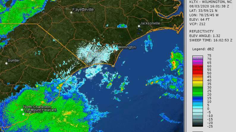
The storm surge hit North Myrtle Beach and Cherry Grove near high tide. Salt water moved almost four blocks inland along Sea Mountain Highway, and a portion of the Sea Cabin Pier at Cherry Grove was destroyed by crashing waves. One Myrtle Beach meteorologist said the damage was worse than 2016's Hurricane Matthew in Cherry Grove. Southport was hit particularly hard by damaging storm surge flooding. A large number of boats moored at the town's marina were slammed together and damaged, and approximately 20 vessels were pushed across the Cottage Creek marsh and came to rest at the Indigo Plantation neighborhood. Bulkheads were eroded and waterfront shops were flooded. An estimated 75 to 100 vehicles were damaged or destroyed by flooding on Oak Island, and on Holden Beach 42 of the 45 identified sea turtle nests were destroyed. Sand dunes were destroyed and significant beach erosion occurred at Ocean Isle Beach and Caswell Beach.
The storm surge moved up the Cape Fear River and reached downtown Wilmington, causing significant flooding on Water Street. Some first floor businesses were damaged by flood water as the river gauge reached its highest reading in history, 9.03 feet MLLW, exceeding the previous record set only two years earlier by Hurricane Florence.
|
|
The highest recorded wind gusts on land were 99 mph in Federal Point, NC (southern New Hanover County) and 87 mph on Oak Island. Gusts as high as 50 mph were recorded as far inland as Elizabethtown. The Frying Pan Tower recorded a gust to 103 mph on an anemometer 135 feet above the ocean surface. Six tornadoes occurred locally during Isaias including one that tore an eight mile long path from Bald Head Island to Southport and had winds up to 115 mph.
Detailed information on the impacts from Hurricane Isaias is available here: https://weather.gov/ilm/HurricaneIsaias2020
The precursor low that eventually became Tropical Storm Kyle developed across eastern North Carolina on August 13, bringing rainfall amounts up to two inches on Masonboro Island, NC. Kyle, the eleventh named storm of 2020, remained over the Atlantic Ocean with winds as strong as 50 mph on August 15 before dissipating the next day.
|
This radar loop from the afternoon of August 13, 2020 shows the developing circulation of what would become Tropical Storm Kyle |
Warm temperatures continued through most of August with area climate stations running 1 to 3 degrees warmer than normal.
September
The month began with a stalled front near the NC/SC state line on September 1. Late evening thunderstorms formed along the front near Fairmont in Robeson County, NC producing flash flooding. The front dissipated the following day allowing hot and humid air to spread north across the Carolinas. This led to several days of unusually hot temperatures for September. High temperatures reached the mid to upper 90s each day September 2-4. Nighttime low temperatures in Myrtle Beach were in the 80s September 2 and 3. The 81 degree low in Wilmington on September 3 was the latest in the year such hot nighttime temperatures had ever occurred and was the sixth time 80 degree lows had occurred within a single year -- another record broken.
Slow moving thunderstorms and heavy rain developed along another stalled front on September 9. Up to eight inches of rain fell along the South Carolina coast resulting in flash flooding on Pawley's Island.
Hurricane Sally made landfalls in south Florida on September 12 and on the Alabama Gulf coast on September 16. The storm weakened inland and became a post-tropical remnant low in Georgia, then tracked eastward across the Carolinas on September 17. Heavy rainfall of five to eight inches during the afternoon and evening caused widespread flash flooding across Darlington and Florence counties and also near Shallotte in Brunswick County, NC.
|
Associated with Tropical Storm Beta's remnants, this waterspout became a tornado as it moved onshore in Myrtle Beach on September 25 |
| Location | County | Rainfall Total |
| Longs | Horry, SC | 8.14" |
| Leland | Brunswick, NC | 7.98" |
| North Myrtle Beach | Horry, SC | 7.58" |
| Darlington | Darlington, SC | 6.78" |
| Hampstead | Pender, NC | 6.54" |
| Conway | Horry, SC | 6.32" |
| Marion | Marion, SC | 5.34" |
| Holly Shelter Swamp | Pender, NC | 5.13" |
A total of four tornado touchdowns (all EF0s) occurred in association with Hurricane Sally's remnants on September 17. Tornadoes were reported from Evergreen and Sardis, SC; and in Hampstead and Wilmington, NC.
Tropical Storm Beta made landfall on the Texas coast early in the morning of September 22. The storm weakened after landfall and became a post-tropical cyclone later that night, but its remnants moved eastward and brought widespread one to two inch rainfall amounts across the Carolinas on September 25. The highest total in the area was 4.50 inches at Lumber River State Park in Robeson County, NC.
Beta's remnants spawned a waterspout that became a tornado as it moved ashore in Myrtle Beach during the afternoon of September 25. Damage occurred to beach chairs, umbrellas, and a storage shed between 72nd and 75th avenue north. (see video to the right) The tornado dissipated about one minute after moving onshore and caused no injuries or fatalities.
Storm survey report from NWS Wilmington.
October
Hurricane Delta was the tenth tropical cyclone of the year to strike the United States when it made landfall in Louisiana on October 9. Delta weakened substantially and became a post-tropical low on October 10 while moving northeastward across Mississippi, however the remnant circulation encountered a stalled front on October 11 and produced four tornadoes across northeastern South Carolina into Brunswick County, NC. The strongest of these tornadoes crossed Interstate 95 near Latta, SC and had wind speeds around 105 mph. Another tornado just north of Conway, SC significantly damaged multiple structures and injured one person.
|
|
Rainfall from the remnants of Hurricane Delta was as much as 3.95 inches in Lumberton, 2.69 inches in Bladenboro, and 2.23 inches in Wilmington.
Hurricane Zeta was a category two storm that struck Louisiana on October 28. The system accelerated northeastward across Alabama, Tennessee, and Virginia where it finally lost its tropical characteristics on October 29. Although Zeta's remnants passed by hundreds of miles to our north and brought very little rain here, strong wind gusts over 40 mph blew trees down in Georgetown and Little River, South Carolina. Peak wind gusts recorded across the area included 57 mph at Wrightsville Beach, NC; 53 mph in Wilmington, NC; 48 mph in Little River, SC; and 43 mph in Darlington, SC.
|
URMA analyzed wind gusts on October 29, 2020 as the remnants of Hurricane Zeta moved north of the Carolinas |
Temperatures in October were very warm, averaging 4 to 5 degrees above normal. Much like was observed during the summer, the largest departures were associated with nighttime low temperatures which averaged 5 to 7 degrees above normal. Wilmington's high of 89 degrees on October 8 was the warmest temperature recorded anywhere in North Carolina throughout the month of October. Almost all precipitation this month fell in association with the two tropical systems.
The 2020 Hurricane Season continued its record-breaking activity into early November. Following closely in the footsteps of category five Hurricane Iota just two weeks earlier, Hurricane Eta grew into a powerful category four hurricane that devastated parts of Nicaragua and Honduras on November 3. Eta turned northeastward across the Caribbean Sea and Cuba, then doubled back and struck the west coast of Florida on Thursday, November 12. The storm then moved northeastward off the Georgia and South Carolina coast that evening, losing its tropical characteristics early in the morning of November 13 while centered 85 miles southeast of Wilmington.
Tropical moisture brought north by Eta was lifted over a cold front producing widespread heavy rain across most of South and North Carolina. This created flash flooding with some rainfall amounts in excess of 8 inches. Road washouts occurred in Pender and Robeson counties and a vehicle was inundated by flooding in the Green Sea community in Horry County, SC. Eleven people were killed in other portions of South and North Carolina by flooding. The Northeast Cape Fear River at Burgaw rose above flood stage and remained there through November 22. Wind gusts as high as 49 mph in Murrells Inlet and 42 mph in Georgetown were associated more with the passage of the cold front than with Eta itself.
|
MRMS/radar estimated 24 hour rainfall from Tropical Storm Eta
|
Actual Gauge Measurements: Nov 12-13
|
A cold snap at the beginning of November brought the first freezing temperatures of the season to some parts of the interior eastern Carolinas. Low temperatures on the morning of November 3 were at or below freezing in Bennettsville, Hartsville, Kingstree, and Florence. Despite this cold start, November's temperatures averaged well above normal throughout the month -- 4 to 5 degrees higher than the 30 year averages. There was a six day long period between November 7 and 12 where most areas saw daily high temperatures in the upper 70s to lower 80s. The coolest temperatures in November occurred behind a Canadian cold front November 18 and 19 when lows dipped into the 30s for two nights. More inland cities experienced their first freeze of the season on the morning of November 19 including Whiteville, Lumberton, and Pembroke.
December
Frequent cold frontal passages in December made weather conditions changeable with large swings observed in day-to-day temperatures. Coastal areas saw their first freezing temperatures of the season on December 2 and 3 as Canadian air pushing south across the Carolinas produced lows in the upper 20s and lower 30s in Wilmington, Myrtle Beach, and Georgetown.
| Location | Last Spring Freeze | First Fall Freeze | 2020 Growing Season Length |
| Wilmington, NC | March 8 | December 2 | 268 days |
| Lumberton, NC | March 8 | November 19 | 255 days |
| Florence, SC | March 1 | November 3 | 246 days |
| North Myrtle Beach, SC | March 1 | December 2 | 275 days |
The warmest weather of the month occurred between December 11 and 14 as high pressure offshore brought several days of mild southwesterly winds. Highs reached the lower 70s in most locations. This warm spell ended with a bang on December 14 as a strong area of low pressure pushed a cold front across the area. Wind gusts as high as 51 mph occurred in Wrightsville Beach, NC. Other wind reports included 44 mph in Wilmington, 43 mph in Florence, and 40 mph in Myrtle Beach, Lumberton, and Darlington.
Another strong cold front moved across the Southeast on Christmas Eve, bringing a line of severe thunderstorms across the area. A weak tornado with wind speeds around 65 mph struck the Chadbourn community in Columbus County during the afternoon, damaging trees but no structures. Straight-line thunderstorm winds damaged homes near Allsbrook in Horry County, SC. Wind gusts measured up to 63 mph occurred during severe thunderstorms in Wilmington during the late evening hours, damaging a number of trees and a home in the Kings Grant neighborhood. Even outside of the severe thunderstorms, most locations saw wind gusts between 35 and 50 mph on Christmas Eve.
|
Half a dozen trees were snapped at Kings Grant Park in Wilmington, NC by thunderstorm wind gusts estimated at 70 mph on December 24, 2020. |
 |
The cold front that produced the squall line moved quickly off the coast early Christmas morning allowing the coldest air of the month to build across the eastern Carolinas. Low temperatures on December 26 were in the lower to middle 20s. Warmth returned by New Years Eve with temperatures in the 60s and 70s again.
2020 City Climate Summaries
Wilmington, North Carolina
    Avg Hi/Dep   Avg Lo/Dep   Avg T/Dep   Warmest   Coolest  Precip/Dep
JAN   62.8/+6.4    42.4/+6.8   52.6/+6.6  78/14th   26/21st    2.36/-1.40
FEB   62.7/+2.8    42.9/+5.0   52.8/+3.9  78/11th   23/22nd    6.86/+3.24
MAR   70.4/+4.0    51.3/+7.5   60.8/+5.7  88/28th   29/1st     4.77/+0.56
APR   74.6/+0.4    51.3/-0.3   62.9/+0.0  88/8th    38/11th    5.57/+2.75
MAY   78.0/-2.7    59.5/-0.5   68.8/-1.6  89/23rd   41/10th    5.39/+0.90
JUN   83.3/-3.6    68.7/+0.0   76.0/-1.8  93/22nd   56/2nd    11.10/+5.92
JUL   91.5/+1.8    74.5/+1.9   83.0/+1.9  97/20th   68/1st     4.65/-2.83
AUG   89.6/+1.5    75.1/+3.8   82.4/+2.7  94/27th   72/21st    8.49/+1.08
SEP   83.7/+0.0    67.7/+2.1   75.7/+1.1  97/4th    50/23rd   10.02/+2.18
OCT   79.4/+3.7    60.5/+5.9   70.0/+4.8  89/8th    50/31st    4.18/+0.29
NOV   72.1/+4.1    50.3/+4.9   61.2/+4.5  82/10th   34/19th    7.05/+3.76
DEC   60.6/+1.3    37.7/-0.1   49.2/+0.6  74/31st   25/26th    2.66/-0.96
--------------------------------------------------------------------------
ANN   75.7/+1.6    56.8/+3.0   66.3/+2.3  97        23        73.10/+15.49

Number of days with Temperatures...
90 degrees of higher:  54 (14 more than normal)
32 degrees or lower:   22 (13 fewer than normal)

Heating degree days: 1788 (624 fewer than normal)
Cooling degree days: 2363 (319 more than normal)

Number of days with precipitation...
0.01" or greater: 143 (8 more than normal)
0.10" or greater: 101 (23 more than normal)
0.50" or greater:  44 (9 more than normal)
1.00" or greater:  22 (5 more than normal)

Thunderstorms occurred on 60 days.
Snow or sleet fell on 1 day.

Average wind speed: 7.7 MPH
Maximum 2-minute wind speed: 47 mph on August 3 (Hurricane Isaias)
Maximum 5-second wind gust: 73 mph on August 3 (Hurricane Isaias)

Florence, South Carolina
    Avg Hi/Dep   Avg Lo/Dep   Avg T/Dep   Warmest   Coolest  Precip/Dep
JAN   62.5/+7.2    42.6/+8.0   52.6/+7.7  79/3rd    27/21st    4.61/+1.38
FEB   63.4/+3.8    43.3/+5.8   53.3/+4.8  83/13th   23/22nd    5.02/+2.10
MAR   72.4/+4.8    52.3/+8.7   62.4/+6.8  90/28th   26/1st     4.43/+1.10
APR   77.3/+1.5    51.4/+0.7   64.4/+1.1  89/9th    39/11th    2.76/+0.14
MAY   81.3/-1.4    59.5/+0.1   70.4/-0.7  92/24th   43/10th   11.07/+7.81
JUN   87.2/-1.2    69.8/+1.8   78.5/+0.3  95/30th   59/2nd     6.25/+1.63
JUL   93.5/+2.5    74.8/+3.4   84.1/+2.9  98/20th   70/14th    7.01/+1.75
AUG   88.8/-0.6    72.9/+2.4   80.8/+0.9  93/31st   66/17th    5.40/+0.16
SEP   82.4/-1.8    65.8/+1.5   74.1/-0.1  95/4th    48/23rd    6.95/+3.28
OCT   78.7/+3.2    57.6/+4.5   68.2/+3.9  87/8th    46/31st    1.48/-1.60
NOV   70.6/+3.5    48.3/+4.6   59.4/+4.0  84/10th   31/19th    4.38/+1.71
DEC   57.1/-0.7    35.0/-1.5   46.0/-1.1  73/13th   22/26th    2.95/-0.06
---------------------------------------------------------------------------
ANN  76.3/+1.7     56.1/+3.3   66.2/+2.5  98        22         62.31/+19.40

Number of days with Temperatures...
90 degrees of higher:  65 (9 more than normal)
32 degrees or lower:   25 (15 fewer than normal)

Heating degree days: 1877 (647 fewer than normal)
Cooling degree days: 2419 (357 more than normal)

Number of days with precipitation...
0.01" or greater: 133 (27 more than normal)
0.10" or greater:  91 (21 more than normal)
0.50" or greater:  43 (14 more than normal)
1.00" or greater:  21 (9 more than normal)

Thunderstorms occurred on 64 days.
No snow or sleet fell.

Average wind speed: 6.8 MPH
Maximum 2-minute wind speed: 36 mph on February 7 (Strong cold front)
Maximum 5-second wind gust: 49 mph on February 7 (Strong cold front)

North Myrtle Beach, South Carolina
    Avg Hi/Dep   Avg Lo/Dep   Avg T/Dep   Warmest   Coolest  Precip/Dep
JAN   62.3/+7.2    44.4/+8.2   53.3/+7.6  76/16th   28/21st    2.00/-1.69
FEB   60.6/+3.2    44.2/+5.6   52.4/+4.4  71/13th   27/22nd    5.77/+2.35
MAR   68.4/+4.3    52.4/+8.1   60.4/+6.2  84/21st   29/1st     4.75/+0.83
APR   73.9/+2.6    54.5/+2.6   64.2/+2.6  88/9th    42/11th    4.24/+1.28
MAY   77.7/-0.9    61.2/+0.4   69.4/-0.3  88/4th    44/12th    4.65/+1.24
JUN   83.3/-1.2    70.5/+1.2   76.9/+0.0  94/28th   60/2nd     4.94/+0.30
JUL   89.4/+1.8    75.8/+2.7   82.6/+2.3  93/31st   72/14th    3.41/-2.49
AUG   87.2/+1.1    75.3/+3.6   81.2/+2.3  92/28th   71/17th    7.38/-0.03
SEP   83.5/+0.1    69.0/+2.1   76.2/+1.1  94/4th    51/23rd    6.81/+0.53
OCT   79.0/+3.9    62.6/+6.9   70.8/+5.4  87/8th    52/31st    2.39/-1.49
NOV   71.3/+4.7    51.9/+5.5   61.6/+5.1  81/9th    35/3rd     6.02/+2.98
DEC   58.5/+0.0    38.2/-0.8   48.3/-0.5  72/14th   24/26th    3.31/-0.15
-------------------------------------------------------------------------
ANN  74.6/+2.2     58.3/+3.7   66.5/+3.0  94        24        55.67/+3.66

Number of days with Temperatures...
90 degrees of higher:  34 (18 more than normal)
32 degrees or lower:   17 (13 fewer than normal)

Heating degree days: 1710 (738 fewer than normal)
Cooling degree days: 2354 (451 more than normal)

Number of days with precipitation...
0.01" or greater: 141
0.10" or greater:  85
0.50" or greater:  39
1.00" or greater:  13

Thunderstorms occurred on 65 days.
No snow or sleet fell.

Average wind speed: 7.6 MPH
Maximum 2-minute wind speed: 46 mph on February 7 (Severe thunderstorm)
Maximum 5-second wind gust: 61 mph on February 7 (Severe thunderstorm)

Lumberton, North Carolina
    Avg Hi/Dep   Avg Lo/Dep   Avg T/Dep   Warmest   Coolest  Precip/Dep
JAN   59.8/+6.1    40.6/+7.4   50.2/+6.8  79/3rd    26/21st    4.19/+2.97
FEB   61.1/+3.1    41.6/+6.0   51.3/+4.5  80/13th   23/22nd    5.08/+2.18
MAR   68.9/+2.6    50.1/+8.1   59.5/+5.4  88/28th   25/1st     3.63/+0.30
APR   74.1/-0.4    49.1/+0.1   61.6/-0.1  86/9th    35/11th    3.17/+0.35
MAY   77.8/-4.3    57.4/-0.2   67.6/-2.2  90/24th   40/12th    8.37/+5.32
JUN   84.5/-4.0    67.8/+0.4   76.2/-1.8  92/30th   57/1st     8.66/+4.32
JUL   91.6/+0.6    72.7/+1.4   82.2/+1.1  96/20th   70/14th    4.94/-0.54
AUG   88.0/-0.3    72.0/+2.3   80.0/+1.0  94/9th    66/17th    4.42/-1.08
SEP   80.9/-2.8    64.9/+2.6   72.9/-0.1  94/4th    48/23rd    7.71/+2.91
OCT   78.3/+2.8    57.2/+5.9   67.7/+4.3  86/8th    46/18th    4.20/+1.63
NOV   70.9/+3.7    48.0/+6.6   59.5/+5.2  82/10th   31/19th    6.47/+3.60
DEC   56.9/+0.1    35.2/-0.4   46.0/-0.2  71/13th   23/26th    3.93/+1.04
--------------------------------------------------------------------------
ANN   74.4/+0.5    54.7/+3.3   64.6/+2.0  96        23        64.77/+21.25

Number of days with Temperatures...
90 degrees of higher:  50 (1 fewer than normal)
32 degrees or lower:   29 (20 fewer than normal)

Heating degree days: 2126 (635 fewer than normal)
Cooling degree days: 2078 (168 more than normal)

Number of days with precipitation...
0.01" or greater: 137 (27 more than normal)
0.10" or greater:  85 (10 more than normal)
0.50" or greater:  41 (10 more than normal)
1.00" or greater:  21 (8 more than normal)

2020 Annual Rainfall Totals

2020 radar-estimated rainfall totals in inches across North and South Carolina
Note: the area of low apparent rainfall along the South Carolina coast is not real but is due to radar beam blockage
Research & Page Author: Tim Armstrong
Last Updated: January 1, 2021


 Coastal Flood