Hurricane Isaias (pronunciation: ees-ah-EE-ahs) was a category one hurricane that made landfall at Ocean Isle Beach, NC during the evening of August 3, 2020 with maximum sustained winds near 85 mph. The storm's rapid movement limited rainfall amounts, however significant storm surge flooding and multiple tornado touchdowns occurred across portions of coastal South and North Carolina.
Storm History
A tropical wave moved off the coast of Africa on July 23 and traveled westward across the tropical Atlantic Ocean. It entered the Caribbean Sea on July 29 as a Potential Tropical Cyclone with winds as high as 45 mph. The system gradually became better organized, and Tropical Storm Isaias was born south of Puerto Rico at 11 p.m. on July 29. Turning northwestward, Isaias made its first landfall on the Dominican Republic early on July 30, then strengthened to a category one hurricane while moving across the southern Bahamas on July 31.
Dry air, increasing wind shear, and passage of the hurricane's center over Andros Island in the Bahamas weakened Isaias back to a tropical storm on August 1. Turning north on August 2, Tropical Storm Isaias encountered the warm Gulf Stream water off the Florida, Georgia and South Carolina coastline. However persistent wind shear prevented the storm from strengthening significantly.
Wind shear weakened slightly during the evening of August 3. Isaias took advantage of the more favorable conditions as it approached land and once again became a category one hurricane. Hurricane Isaias made landfall at Ocean Isle Beach, North Carolina just after 11 pm on August 3 with maximum sustained winds near 85 mph.
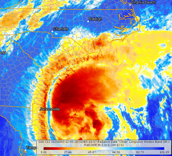
Color-enhanced Infrared satellite loop showing Hurricane Isaias making landfall and moving inland across eastern North Carolina. August 3-4, 2020
Storm Surge
A damaging storm surge occurred along the Horry County coastline during the evening high tide on August 3. The middle portion of the Sea Cabin Pier at Cherry Grove was destroyed. Homes in low lying areas near the beach were flooded and dune erosion was severe. Main Street between Ocean Blvd and Hillside Drive was closed due to flooding. Sea Mountain Highway (SC Highway 9) was covered with 12 to 18 inches of water up to four blocks in from the beach. In North Myrtle Beach water up to one foot deep reached about a block inland. Ocean Blvd in Myrtle Beach was closed due to flooding for a time, and in Garden City North Waccamaw Drive was flooded and closed during high tide.
Damaging storm surge flooding continued northward along the south-facing coastline of Brunswick County including Holden Beach, Ocean Isle Beach, Oak Island, and Southport. In Southport, extensive damage occurred to a hundred or more boats moored at the town's marina. Approximately twenty small and medium sized boats were shown in news photos to have been pushed across the Cottage Creek marsh and came to rest at the Indigo Plantation neighborhood. Up to three feet of storm surge flooding caused heavy damage to waterfront shops in Southport. Bulkheads were eroded along East Bay Street and a portion of the sidewalk collapsed. On Oak Island storm surge flooding damaged or destroyed an estimated 75-100 vehicles. Sand dunes were washed onto streets up to three blocks inland. On Holden Beach 42 of the 45 sea turtle nests identified before the storm were destroyed. Town officials estimated damage around $40 million. At Ocean Isle Beach and Caswell Beach significant beach erosion occurred and sand dunes were destroyed.
The storm surge moved up the tidal portion of the Cape Fear River into downtown Wilmington, causing significant street flooding and damaging some first-floor businesses along Water Street. The downtown river gauge reached its highest level in history at 9.03 feet MLLW, eclipsing the previous record of 8.28 feet set just two years earlier during Hurricane Florence.
|
|
|
|
|
|
Winds
Gusts over hurricane force occurred at a number of weather stations along the North Carolina coast. These winds caused damage to trees, power lines, and some structures.
The highest wind gusts occurred at the beaches near and east of the landfall point across Brunswick, New Hanover, and Pender counties in southeastern North Carolina.The Fort Anderson State Historic Site in Brunswick County, NC said just as many trees were lost in Isaias as were lost in Hurricane Florence two years earlier. Brunswick County reported 53,000 customers without power at the height of the storm. Across New Hanover county downed trees and power lines knocked out electrical service to 85,000 residents. A few business signs were blown down, and most traffic lights were out of service during and immediately after the storm. Pender County, NC officials reported 27,500 residents lost electrical power. Damage to trees and power lines were mainly limited to the coastal sections of the county.
| Location | County | peak gust (mph) | lowest pressure (millibars) |
| Frying Pan Shoals Tower (135 feet elev.) | offshore, NC | 103 | |
| Federal Point (Weatherflow, 50 feet elev.) | New Hanover, NC | 99 | 996.0 |
| Oak Island (Weatherflow) | Brunswick, NC | 87 | 989.0 |
| Wrightsville Beach-Johnnie Mercer Pier | New Hanover, NC | 85 | 993.5 |
| Oak Island-SW Yacht Dr. | Brunswick, NC | 83 | 989.2 |
| Surf City Bridge (65 feet elev.) | Pender, NC | 83 | |
| Lockwoods Folly Inlet (Weatherflow) | Brunswick, NC | 77 | 989.0 |
| Buoy 5 mi. SE Wrightsville Beach | offshore, NC | 76 | 995.0 |
| Buoy 2 mi. S Sunset Beach | offshore, NC | 76 | 988.3 |
| Wilmington Airport | New Hanover, NC | 73 | 992.6 |
| Holden Beach | Brunswick, NC | 73 | |
| Crescent Beach-Tilghman Estates | Horry, SC | 70 | 992.6 |
| Bald Head Island (NC ECONET) | Brunswick, NC | 70 | 995.1 |
| Winyah Bay Range A Rear Light (Weatherflow, 50 feet) | Georgetown, SC | 69 | 995.0 |
| Southport Airport | Brunswick, NC | 66 | 991.5 |
| Holly Shelter Swamp-Back Island (fire weather station) | Pender, NC | 66 | |
| Frying Pan Shoals Buoy | offshore, NC | 64 | 998.8 |
| Buoy 27 mi. SE Wrightsville Beach | offshore, NC | 64 | 1004.5 |
| Sunny Point Military Terminal (fire weather station) | Brunswick, NC | 63 | |
| Castle Hayne (NC ECONET) | New Hanover, NC | 59 | 992.4 |
| Green Swamp-Nature Conservancy (fire weather station) | Brunswick, NC | 56 | |
| Scotts Hill | Pender, NC | 54 | 992.9 |
| North Myrtle Beach Airport | Horry, SC | 53 | 993.2 |
| Myrtle Beach Airport | Horry, SC | 53 | 997.2 |
| Murrells Inlet (Weatherflow) | Georgetown, SC | 51 | 996.0 |
| Elizabethtown Airport | Bladen, NC | 51 | 998.2 |
| Lake Arrowhead (Weatherflow) | Horry, SC | 49 | 991.0 |
| Georgetown Airport | Georgetown, SC | 49 | 1001.0 |
| Whiteville (fire weather station) | Columbus, NC | 49 | |
| Georgetown | Georgetown, SC | 47 | 998.0 |
| Georgetown Memorial Hospital | Georgetown, SC | 46 | 1001.2 |
| Whiteville Airport | Columbus, NC | 43 | 996.9 |
| Conway | Horry, SC | 41 | |
| Whiteville (NC ECONET) | Columbus, NC | 35 | 999.7 |
| Florence Airport | Florence, SC | 30 | 1007.5 |
|
|
|
|
Driving home after Hurricane Isaias |
Tornadoes
Hurricane Isaias produced six confirmed tornado touchdowns across our portion of the Carolinas. The strongest was an EF2 tornado that was on the ground for over eight miles from Bald Head Island to Southport around 8:00 pm on August 3. Based on observed damage, this tornado likely had winds of 115 mph and a maximum path width of 70 yards. A short-lived tornado at Garden City Beach at 8:20 pm on August 3 injured one person and damaged several homes.
For more details on Hurricane Isaias' tornadoes, please see our GIS Storymap on Hurricane Isaias.
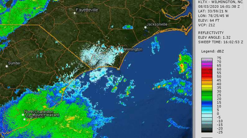
Radar loop of Hurricane Isaias making landfall, August 3-4, 2020
Rainfall Totals
|
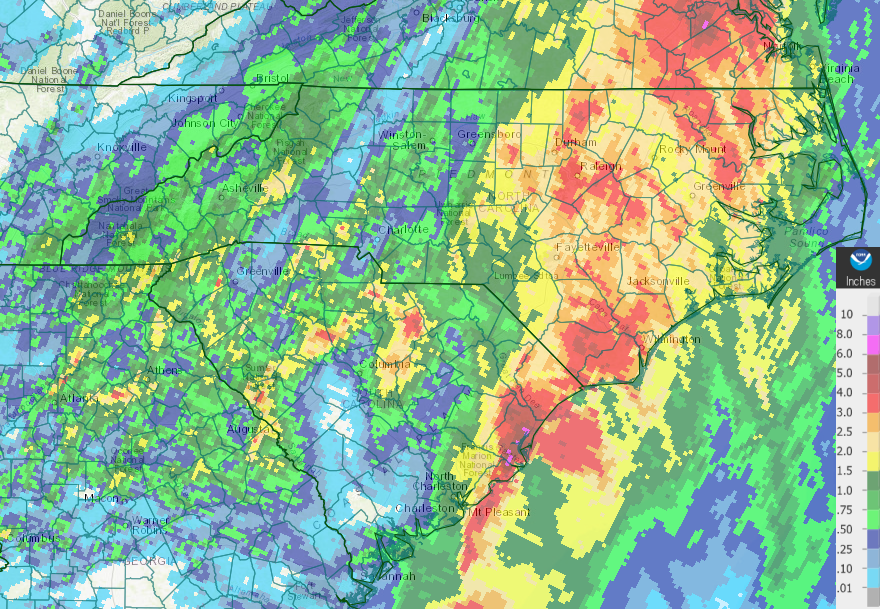
Radar estimated precipitation from Hurricane Isaias. The highest totals, over six inches, occurred across coastal Georgetown County, SC. No significant flooding due to rainfall occurred. |
| Location | County | Station ID | Rainfall (in.) |
| Pawley's Island 2.4 miles NW | Georgetown | SC-GT-42 | 6.80 |
| Georgetown 6.0 miles S | Georgetown | SC-GT-4 | 6.54 |
| Georgetown NWS coop observer | Georgetown | GEOS1 | 5.80 |
| Winyah Bay-North Inlet | Georgetown | NIWS1 | 5.79 |
| Pawley's Island 0.8 miles WNW | Georgetown | SC-GT-26 | 5.53 |
| Georgetown 11.2 miles SW | Georgetown | SC-GT-38 | 5.32 |
| Georgetown 1.0 mile E | Georgetown | SC-GT-27 | 5.31 |
| Pawley's Island 2.6 miles N | Georgetown | SC-GT-24 | 5.08 |
| Leland 5.7 miles WSW | Brunswick | NC-BR-2 | 5.05 |
| Pawley's Island 3.0 miles WNW | Georgetown | SC-GT-36 | 4.96 |
| Leland 4.2 miles WNW | Brunswick | NC-BR-95 | 4.89 |
| Myrtle Beach 8.9 miles WSW | Horry | SC-HR-119 | 4.85 |
| Murrells Inlet 0.3 miles SSW | Georgetown | SC-GT-2 | 4.50 |
| Murrells Inlet 4.0 miles NE | Horry | SC-HR-14 | 4.49 |
| Pawley's Island 5.6 miles NNE | Georgetown | SC-GT-9 | 4.31 |
| Calabash 1.9 miles NNE | Brunswick | NC-BR-1 | 4.26 |
| Murrells Inlet 1.9 miles NNE | Horry | SC-HR-122 | 4.15 |
| Murrells Inlet 0.9 miles NNE | Georgetown | SC-GT-19 | 4.06 |
| Murrells Inlet 1.7 miles N | Horry | SC-HR-63 | 4.00 |
| Myrtle Beach 9.2 miles WSW | Horry | SC-HR-66 | 3.95 |
| Myrtle Beach 8.4 miles WNW | Horry | SC-HR-67 | 3.95 |
| Pawley's Island miles 1.8 W | Georgetown | SC-GT-33 | 3.91 |
| Whiteville Fire Weather station | Columbus | NHWI | 3.91 |
| Elizabethtown 6.2 miles NW | Bladen | NC-BD-2 | 3.88 |
| Burgaw 0.3 miles NE | Pender | NC-PD-22 | 3.85 |
| Socastee 3.3 miles SW | Horry | SC-HR-111 | 3.84 |
| Whiteville (NC ECONET) | Columbus | WHIT | 3.77 |
| Myrtle Beach 8.4 miles WNW | Horry | SC-HR-27 | 3.76 |
| Bolivia 6.2 miles SSW | Brunswick | NC-BR-96 | 3.73 |
| Whiteville 6.1 miles NW | Columbus | NC-CL-25 | 3.68 |
| Oak Island 0.9 miles ENE | Brunswick | NC-BR-56 | 3.66 |
| Myrtle Beach 5.0 miles WNW | Horry | SC-HR-46 | 3.64 |
| Myrtle Beach 5.2 miles SW | Horry | SC-HR-73 | 3.56 |
| Myrtle Beach 4.8 miles NNW | Horry | SC-HR-106 | 3.55 |
| Long Beach 2.0 miles NE | Brunswick | NC-BR-93 | 3.53 |
| Bolivia 8.0 miles SW | Brunswick | NC-BR-73 | 3.52 |
| North Myrtle Beach 3.5 miles E | Horry | SC-HR-109 | 3.50 |
| Leland 1.4 miles WNW | Brunswick | NC-BR-98 | 3.45 |
| Longs coop observer | Horry | BCLS1 | 3.42 |
| Bolivia 7.8 miles SW | Brunswick | NC-BR-71 | 3.38 |
| Myrtle Beach 4.5 miles NNW | Horry | SC-HR-123 | 3.38 |
| Georgetown 13.3 miles NW | Georgetown | SC-GT-44 | 3.35 |
| Longs 2.6 miles NNW | Horry | SC-HR-116 | 3.33 |
| Green Swamp-Nature Conservancy | Brunswick | NNAC | 3.32 |
| Myrtle Beach coop observer | Horry | MYBS1 | 3.31 |
| Hemingway 6.3 miles SE | Georgetown | SC-GT-15 | 3.22 |
| Tabor City 3.5 miles NE | Columbus | NC-CL-26 | 3.20 |
| Bladenboro 2.0 miles NNW | Bladen | NC-BD-1 | 3.18 |
| Bolivia 7.6 miles SW | Brunswick | NC-BR-45 | 3.18 |
| Myrtle Beach 2.4 miles ENE | Horry | SC-HR-64 | 3.15 |
| Sunset Beach 1.7 miles WNW | Brunswick | NC-BR-6 | 3.14 |
| Surfside Beach 1.0 miles NE | Horry | SC-HR-39 | 3.05 |
| Georgetown 5.3 miles NNE | Georgetown | SC-GT-1 | 3.04 |
| Myrtle Beach Airport | Horry | KMYR | 2.97 |
| Conway Fire Weather station | Horry | SHOR | 2.94 |
| Myrtle Beach 7.4 miles NNW | Horry | SC-HR-75 | 2.92 |
| Oak Island 2.3 miles E | Brunswick | NC-BR-35 | 2.90 |
| Holden Beach 1.7 miles ENE | Brunswick | NC-BR-83 | 2.85 |
| Nichols 2.5 miles ESE | Marion | SC-MN-9 | 2.85 |
| Whiteville Airport | Columbus | KCPC | 2.78 |
| Southport 5.8 miles W | Brunswick | NC-BR-85 | 2.75 |
| Cape Fear River Lock and Dam | Bladen | CFPN7 | 2.75 |
| Holly Shelter Swamp-Back Island | Pender | NBAC | 2.52 |
| Southport 5.9 miles W | Brunswick | NC-BR-13 | 2.47 |
| Bald Head Island (NC ECONET) | Brunswick | BALD | 2.45 |
| Galivants Ferry coop observer | Horry | GALS1 | 2.45 |
| Southport 2.7 miles NNW | Brunswick | NC-BR-61 | 2.44 |
| North Myrtle Beach Airport | Horry | KCRE | 2.38 |
| Elizabethtown Airport | Bladen | KEYF | 2.34 |
| Hampstead 4.1 miles WNW | Pender | NC-PD-31 | 2.23 |
| William O. Huske Lock and Dam | Bladen | DRTN7 | 2.20 |
| Castle Hayne (NC ECONET) | New Hanover | CAST | 2.17 |
| Lumber River State Park | Robeson | LRPN7 | 2.14 |
| Conway Airport | Horry | KHYW | 2.13 |
| Southport 1.0 miles NE | Brunswick | NC-BR-14 | 2.10 |
| Mullins coop observer | Marion | MULS1 | 2.10 |
| Whiteville-Soules Swamp | Columbus | WHSN7 | 2.08 |
| Long Beach 2.9 miles NE | Brunswick | NC-BR-7 | 2.01 |
| Lumberton coop observer | Robeson | LBRN7 | 2.00 |
| Wilmington Airport | New Hanover | KILM | 1.95 |
| Sunny Point Military Terminal | Brunswick | NSUN | 1.94 |
| Fair Bluff | Robeson | FBLN7 | 1.87 |
| Topsail Beach 2.1 miles W | Pender | NC-PD-28 | 1.85 |
| Florence Airport | Florence | KFLO | 1.58 |
| Lumberton RAWS | Robeson | NLUM | 1.38 |
| Kingstree Airport | Williamsburg | KCKI | 0.50 |
| Bennettsville Airport | Marlboro | KBBP | 0.47 |
After passing through the Carolinas, Tropical Storm Isaias continued to move north and impacted major cities in the Mid-Atlantic and Northeast including Norfolk, Philadelphia, and New York City. Flooding due to heavy rainfall and strong wind gusts over 70 mph extended up the coast as far north as Long Island, NY. Widespread power outages occurred, in some places for a week.
Additional Links of Interest
NWS Wilmington ArcGIS Storymap on Hurricane Isaias: arcg.is/PPuO8
Wilmington Star-News gallery of Brunswick County, NC damage: https://www.starnewsonline.com/photogallery/NC/20200804/PHOTOGALLERY/804009990/PH/1
USGS Flood Event Viewer: https://stn.wim.usgs.gov/FEV/#2020HurricaneIsaias
USGS Field Crews Document Isaias' Effects Along Atlantic Coast: https://www.usgs.gov/news/usgs-field-crews-document-isaias-effects-along-atlantic-coast
National Hurricane Center archive of Isaias advisories and forecasts: https://www.nhc.noaa.gov/archive/2020/ISAIAS.shtml
National Weather Service Charleston, SC Isaias event summary: https://www.weather.gov/chs/HurricaneIsaias-Aug2020
National Weather Service Newport/Morehead City, NC Isaias event summary: https://www.weather.gov/mhx/HurricaneIsaias080420
Research & Page Author: Tim Armstrong
Last Updated: Oct 10, 2020


 Coastal Flood