During the latter part of November, several unique weather systems in the north and northeast Pacific combined to produce a long lasting destructive surf event along northeast facing shores of the Hawaiian Islands. Surf heights of 15 to 25 feet, with some sets up to 40 feet were reported beginning on the 20th and peaking on the 21st before slowly diminishing. Although surf events of this magnitude occur several times a year in Hawaii, they generally come from major storms far to the northwest of Hawaii and thus impact northwest facing shores. Over the eons, coastlines on these sides of the islands have been "shaped" to be able to handle such high surf with minimal impact. High surf of this magnitude from other directions is exceedingly rare, and thus when it occurs, can cause significant damage. Below is a review of the meteorological events which led to high surf.
A large high pressure system develops in the north Pacific, about 800 miles north of Hawaii. The difference in pressure between the center of the high pressure (1047 mb or 30.90 in) and lower pressures away from the high result in a large area of strong winds (30 to 40 knots or 35 to 45 mph) developing around the entire high. With air moving clockwise around high pressure, this results in a large area (fetch) of northerly winds pointed almost directly toward the state. Windspeeds as measured by satellite {image below} clearly show the circle of strong relatively winds {red areas} around the high pressure center, where light and variable winds {blue areas} are occurring.
Winds of this magnitude over such an area create significant wave heights of around 20 feet. In fact, ship reports from the north Pacific indicated that 15 to 20 foot waves were the case. As these waves travel southward out of their generation area, they become a swell and being to slowly diminish. However due to the relatively short distance between the fetch area and Hawaii, given no other influences, this swell would still be in the range of 8 to 12 feet when it would reach the north and northeast shores. But that wasn't going to be the case.
Low pressure developed along an old cold front about 450 miles northeast of Hawaii. The low is quite evident in the satellite image below. This low pressure had the effect of increasing the pressure difference between the massive high pressure and that low, which in turn strengthened the winds to speeds around 50 knots (about 60 mph).
The low pressure continued to strengthen (readily apparent by the comma shape to the clouds), and the strongest surface winds now approached 60 knots (70 mph), or just a little below hurricane force. The low also moved very little, and therefore the winds have time to build the seas even higher. Ships at this point were steering clear of this storm, so we did not get any direct observations of the wave heights. Based upon winds measured from satellite, significant wave heights should have been on the order of 30 to 40 feet just to the northwest of the low pressure center where the winds were strongest.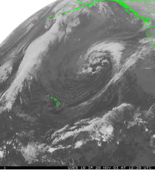
The large area of very strong winds as measured by satellite are clearly indicated below.
The next image shows a closer view of these very strong winds.
The fetch area outlined above clearly shows that it is "aimed" directly at the state, and in a direction that would suggest that northeast facing shores would be most impacted by the large swell. This fetch area is extremely close to the state, thus there is little distance for the large swell generated by the storm to substantially "decay". In situations like this, swell heights reaching Hawaii are still 55-65% of the wave heights in the fetch area. "Typical" winter swells travelling 2000 miles or more to reach Hawaii are only 25-35% the height of the waves in the fetch area. So for this setup, expected swell heights would be in the 20 to 25 foot range, with the highest sets reaching close to 40 feet. Indeed, this is what happened. Swells travel across the ocean at speeds related to their period, and based on that and the distance from Hawaii to the fetch area, the swell was about 24 hours away.
The low pressure has not moved much, but is in fact beginning to slowly weaken, although winds near the low are still around 50 knots. High surf has reached Hawaii, with north/northeast facing shores taking the brunt of the high surf. A sample of surf heights reported to this office include:
The low pressure, although still not having moved much, was quickly weakening. The satellite image below, taken during the afternoon of November 22, shows this weakening trend. By this time, winds with the low pressure were down to 30-40 knots (35-45 mph), however these winds were in a small area and not pointing toward Hawaii. These are not optimal conditions to produce both large enough waves and a swell that would continue to affect the state. Thus the high surf event was winding down.
With large surf events, water is piled up along the coast, somewhat analogous to "storm surge" associated with tropical systems. This is called "Wave Setup". How high this "setup" or water gets along the coast is dependent on wave height, wave period and the depth of water that the waves are breaking in. In general, cases like this can result in water levels of several feet above normal. This can create problems along areas of the coast that are just barely above sea level, which is quite common on the east sides of Oahu and the Big Island especially. It was this high water, along with wave action on top of that, which resulted in considerable property damage (flooded/damaged homes), road closures, and beach erosion.
Here are a couple of pictures of the waves along the normally rather tranquil east shore of Oahu, courtesy Maureen Ballard

Finally, a couple of pictures of the damage cause by the high surf on the Hilo Bayfront Highway on the Big Island, courtesy Dick Mitsutani


 Follow us on YouTube