National Weather Service United States Department of Commerce

Mix of Sun and Clouds today, Gusty north to northwest winds and Lower than Normal Temperatures

North to northwest winds will draw down a cooler than normal airmass today. The high pressure system responsible for this pattern will drift eastward across lower Michigan on Monday keeping the temperature well below normal for this time of the year. Read More >

Summary

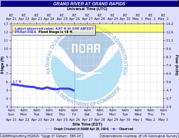
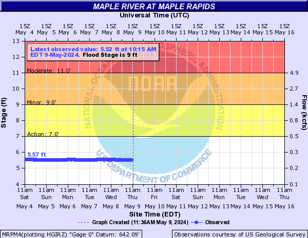
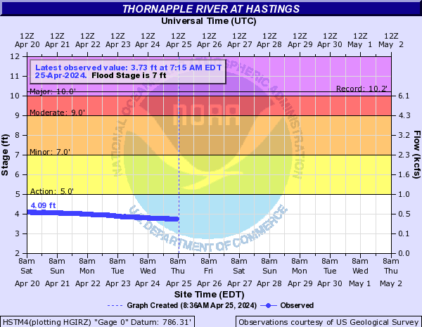
Much of Lower Michigan has had 3 to 7 inches of rain over the last week or so, which has caused widespread flooding across the area.

River Level Charts

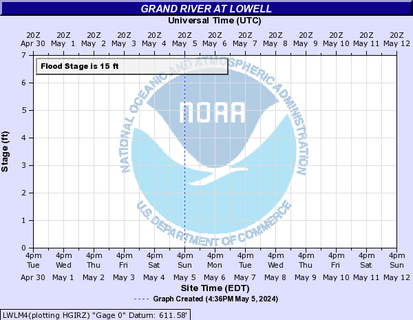
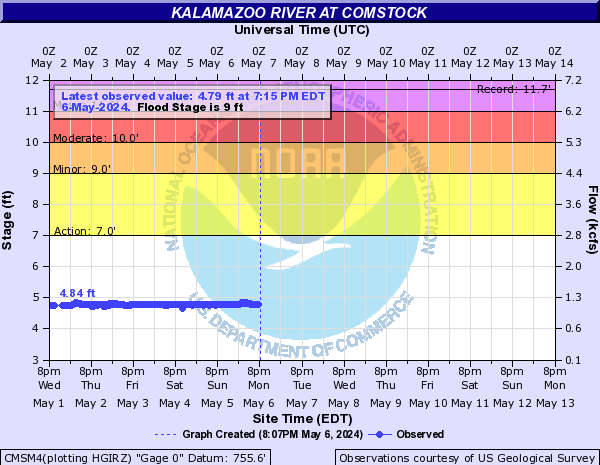
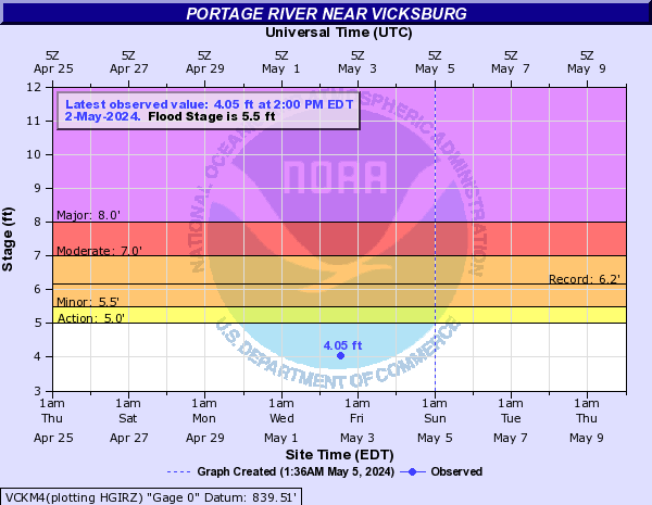
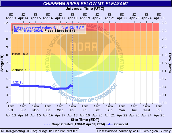
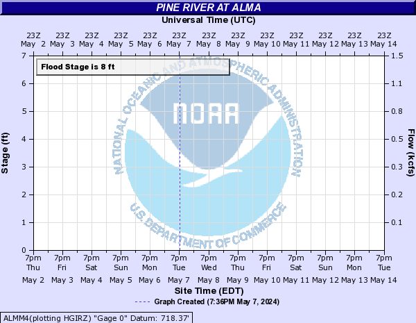
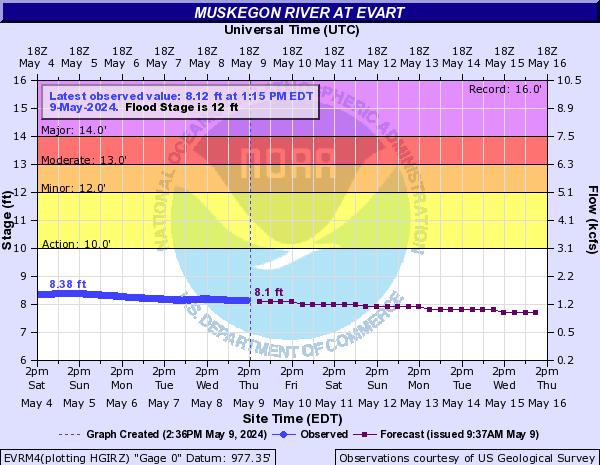
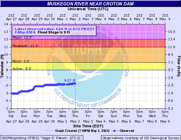
The blue curve on the left half of the chart is the measured river level over the past several days.

The purple curve on the right half of the chart is the forecast river level over the next week.

Forecasts take into account any expected precipitation over the next 24 hours.

Click on a chart for additional information about that river point, including flood impact levels and crest history.

Click here for current information on all river levels around the area. The river points below are only a partial selection.


Grand River Basin

Hydrograph

Grand River at Lansing


Hydrograph

Grand River at Ionia


Hydrograph

Grand River at Lowell


Hydrograph

Grand River at Ada


Hydrograph

Grand River at Comstock Park


Hydrograph

Grand River at Grand Rapids


Hydrograph

Grand River at Robinson Township

Hydrograph

Maple River at Maple Rapids

Hydrograph

Red Cedar River at East Lansing


Hydrograph

Thornapple River at Hastings

Hydrograph

Thornapple River at Caledonia


Muskegon River, Kalamazoo River, Portage River, Chippewa River, Pine River
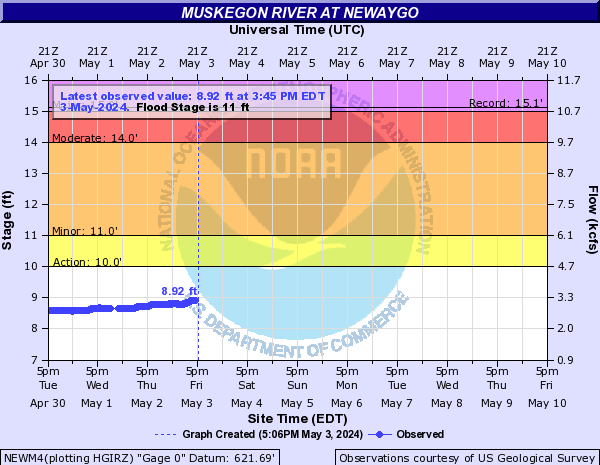
 

Hydrograph Hydrograph Hydrograph
Muskegon River at Evart Muskegon River at Croton Muskegon River at Newaygo


Hydrograph

Muskegon River at Bridgeton

Hydrograph

Kalamazoo River at Comstock

Hydrograph

Portage River at Vicksburg


Hydrograph

Chippewa River below Mt. Pleasant


Hydrograph

Pine River at Alma


Notable Facts about this Flood

  • The Chippewa River at Mt. Pleasant reached its 7th highest crest in history.
  • The Pine River at Alma reached its 4th highest crest in history.
  • The Thornapple River at Hastings reached its 6th highest crest in history.
  • The Grand River at Ionia reached its 7th highest crest in history
  • The Grand River at Lowell reached it's 8th highest crest in history
  • The Grand River at Ada reached its 4th highest crest in history
  • The Grand River at Comstock Park reached it's 7th highest crest in history
  • The Grand River at Grand Rapids reached its 4th highest crest in history


nws logo             

Media use of NWS Web News Stories is encouraged!
            Please acknowledge the NWS as the source of any news information accessed from this site.


Return to NWS Grand Rapids Home Page

            
nws logo