Overview
|
A slow moving area of low pressure sparked numerous thunderstorms across the area on Saturday August 5, 2023. This resulted in a widespread 1 - 1.5 inches of rain with the highest totals exceeding 6+ inches of rain. Some locations reported over 10 inches of rain. Despite this, only localized areas of flash flooding were reported - mainly in Sioux county, IA and Kingsbury county, SD. Antecedent drought conditions limited impacts including rises on area rivers. There were also a few rotating storms which produced 2 tornadoes. Rainfall continued off and on into the Sunday, although rainfall amounts were much less.
Information is still being gathered, so check back for updates! |
 Unconfirmed Tornado South of Sioux Center, IA. (Mike Frangenberg) |
Tornadoes:
|
Tornado - LOCATION
Track Map 
Downloadable KMZ File |
||||||||||||||||
The Enhanced Fujita (EF) Scale classifies tornadoes into the following categories:
| EF0 Weak 65-85 mph |
EF1 Moderate 86-110 mph |
EF2 Significant 111-135 mph |
EF3 Severe 136-165 mph |
EF4 Extreme 166-200 mph |
EF5 Catastrophic 200+ mph |
 |
|||||
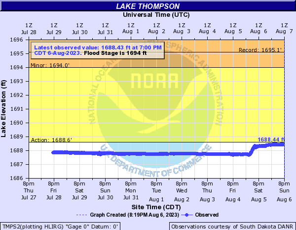
Flooding
On going drought conditions prohibited most locations outside of the James River from rising above flood stage. However, heavy rainfall was enough to cause some rises on area creeks, lakes, and rivers.
Hydrographs
 |
 |
 |
 |
| Floyd River Near Struble | Little Floyd River Near Sanborn | Lake Thompson | Big Sioux River Near Brandon |
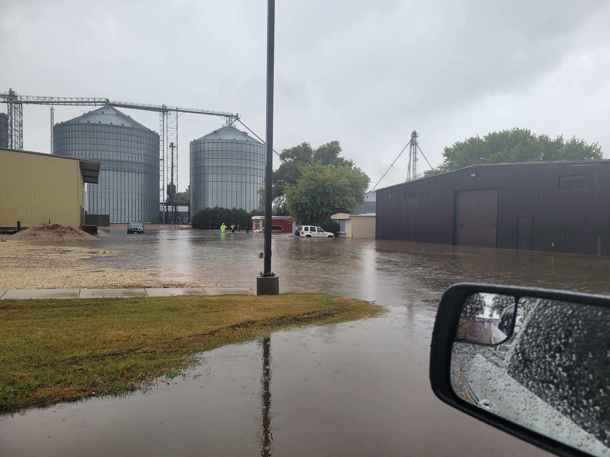
Radar/Photos
 |
 |
 |
 |
| Flooding in Sioux Center, IA (Sioux County Sheriff Dept.) |
Flooding in Sioux Center, IA (Sioux County Sheriff Dept.) |
Flood Damage North of De Smet, SD (Caryn Hojer) |
Flood Damage North of De Smet, SD (Caryn Hojer) |
Photos & Video
Additional Rainfall and Damage Photos
 |
 |
 |
 |
| Rainfall in southeastern Sioux Falls (Jesse Peterson) |
Flooding North of De Smet, SD (Caryn Hojer) |
Water Flattened Corn North of De Smet, SD (Caryn Hojer) |
24 hour Rainfall near Bruce, SD (Mary Dawson) |
Radar
Check out these radar loops, as well as a table of select rainfall totals and a map of radar estimated rainfall.
.gif) |
.gif) |
 |
 |
| Radar Reflectivity 2 PM to 8 PM Saturday August 5th, 2023 | Radar Reflectivity 8 PM to 11 PM Saturday August 5th, 2023 | Notable Two Day Precipitation Totals for August 5-6, 2023 | Radar Estimated Rainfall August 5-6, 2023 |
Storm Reports
| Report Time | County | Location | ST | Event Type | Mag. | Source | Remark |
| Sat Aug 05 2023 12:02 PM CDT |
O'Brien | Sanborn | IA | Flood | 0 | Public | Yard flooding and small creek overflowing. |
| Sat Aug 05 2023 2:30 PM CDT |
Sioux | 3 NNE Maurice | IA | Tornado | 0 | Public | Social media report with picture of tornado south of Sioux Center IA. 1 mile east of Highway 75 on Highway 10 looking southwest. |
| Sat Aug 05 2023 2:36 PM CDT |
Sioux | 2 SW Sioux Center | IA | Tornado | 0 | Public | Reported by Iowa State Patrol: Sioux Center Fire reported tornado on the ground 2.5 SW of Sioux Center. |
| Sat Aug 05 2023 3:21 PM CDT |
Sioux | 1 NNW Sioux Center | IA | Flash Flood | 0 | Law Enforcement | Sioux County Sheriffs Office posted on their website: No travel advised in Sioux Center due to flooding. |
| Sat Aug 05 2023 3:32 PM CDT |
Sioux | Rock Valley | IA | Flash Flood | 0 | Law Enforcement | Nixle report from Sioux County Sheriff office: Please avoid Main St by 12th St in Rock Valley, also 14th St from 12th Ave to 10th Ave due to flooding. |
| Sat Aug 05 2023 3:40 PM CDT |
Sioux | 1 N Sioux Center | IA | Flash Flood | 0 | Dept of Highways | US 75 is blocked in both directions between County Road B46 and B30, due to standing water. |
| Sat Aug 05 2023 3:49 PM CDT |
Sioux | Sioux Center | IA | Flash Flood | 0 | Law Enforcement | Nixle report from Sioux County Sheriff office: There is no travel advised in Sioux Center due to flooding. There are several vehicles stuck in flooded streets. |
| Sat Aug 05 2023 3:49 PM CDT |
Sioux | Rock Valley | IA | Flash Flood | 0 | Law Enforcement | Nixle report from Sioux County Sheriff office: Some streets in Rock Valley have become impassable due to flash flooding. Please do not drive through standing water. |
| Sat Aug 05 2023 5:15 PM CDT |
Sioux | Boyden | IA | Flash Flood | 0 | Public | Public phone call to report 7 inches approximate of rain so far in Boyden IA. Street flooding in town. Mid storm report. |
| Sat Aug 05 2023 5:38 PM CDT |
Sioux | Boyden | IA | Flash Flood | 0 | Dept of Highways | US 18 is closed in both directions between County Road K64 and County Road L14 due to standing water over the highway. |
| Sat Aug 05 2023 6:25 PM CDT |
Plymouth | 2 SW Le Mars | IA | Tstm Wind Gust | 71 | AWOS | |
| Sun Aug 06 2023 10:00 PM CDT |
Kingsbury | 4 SSW Erwin | SD | Flash Flood | 0 | Emergency Manager | 437th Avenue damaged and partially washed out due to heavy rainfall. |
| Sun Aug 06 2023 10:00 PM CDT |
Kingsbury | 3 SW Erwin | SD | Flash Flood | 0 | Emergency Manager | 202nd Street damaged and washed out due to heavy rainfall. |
Rain Reports
Public Information Statement
National Weather Service Sioux Falls SD
1233 PM CDT Sun Aug 6 2023

...PRECIPITATION REPORTS...

Location                     Amount    Time/Date       Provider

...Iowa...

...Buena Vista County...
Storm Lake 3.1 S             2.32 in   0700 AM 08/06   COCORAHS
0.8 SW Linn Grove            2.02 in   1100 AM 08/06   COOP

...Cherokee County...
2 E Meriden                  3.76 in   1119 PM 08/05   Mesonet
Cherokee Municipal Airport   2.13 in   1055 AM 08/06   AWOS

...Clay County...
1.1 NE Peterson              4.01 in   0700 AM 08/06   UCOOP
3.2 W Spencer                2.99 in   1045 AM 08/06   HADS
Spencer Municipal Airport    2.64 in   1053 AM 08/06   ASOS
Spencer 7.0 S                2.18 in   0744 AM 08/06   COCORAHS

...Dickinson County...
TERRIL                       1.71 in   1059 AM 08/06   CWOP
Milford 0.2 WSW              1.50 in   0700 AM 08/06   COCORAHS
Lake Park 0.2 N              1.44 in   0800 AM 08/06   COCORAHS
Milford 1.0 SSE              1.42 in   0700 AM 08/06   COCORAHS
Lake Park                    1.17 in   1100 AM 08/06   CWOP

...Ida County...
Arthur 3.7 SSW               4.12 in   0657 AM 08/06   COCORAHS

...Lyon County...
George                       3.32 in   1130 PM 08/05   Mesonet
0.5 S Rock Rapids            1.35 in   1015 AM 08/06   UCOOP
Larchwood 1.2 NNE            1.31 in   0800 AM 08/06   COCORAHS

...O'Brien County...
Sanborn 0.3 ENE              4.41 in   0800 AM 08/06   COCORAHS
Paullina                     3.28 in   1117 PM 08/05   Mesonet
Sheldon                      2.68 in   0700 AM 08/06   COOP
Hartley                      1.91 in   1100 AM 08/06   CWOP
Hartley 0.3 N                1.61 in   0700 AM 08/06   COCORAHS

...Osceola County...
Sibley                       2.80 in   0800 AM 08/06   COOP

...Plymouth County...
Remsen                       4.70 in   1132 PM 08/05   Broadcast Media
3 NNW Le Mars                4.11 in   1115 PM 08/05   Mesonet
3 ENE Remsen                 3.86 in   1118 PM 08/05   Mesonet
Le Mars 1.0 E                3.25 in   0530 AM 08/06   COCORAHS
Le Mars 0.9 SE               3.02 in   0700 AM 08/06   COCORAHS
6.2 NW Hinton                1.73 in   1045 AM 08/06   UCOOP
Loess Hills Tnc Broken       1.51 in   1011 AM 08/06   RAWS

...Sioux County...
1 S Sioux Center             9.02 in   1113 PM 08/05   Mesonet
2 S Sioux Center             8.88 in   1114 PM 08/05   Mesonet
1 W Boyden                   8.38 in   1109 PM 08/05   Mesonet
2 E Hull                     7.87 in   1111 PM 08/05   Mesonet
Sioux Center 2.6 N           7.57 in   0700 AM 08/06   COCORAHS
5 W Sioux Center             6.17 in   1114 PM 08/05   Mesonet
Hull                         5.62 in   1112 PM 08/05   Mesonet
5 WSW Rock Valley            5.48 in   1128 PM 08/05   Mesonet
0.7 N Rock Valley            4.31 in   1100 AM 08/06   HADS
3 NW Granville               3.80 in   1129 PM 08/05   Mesonet
1 SSE Orange City            3.50 in   0542 AM 08/06   Public
Floyd River                  3.07 in   1100 AM 08/06   COOP
Orange City 0.4 WNW          2.95 in   0800 AM 08/06   COCORAHS
Hawarden                     2.68 in   1100 AM 08/06   CWOP

...Woodbury County...
Sioux Gateway Airport        1.03 in   1100 AM 08/06   ASOS

...Minnesota...

...Jackson County...
Lakefield                    0.82 in   1058 AM 08/06   CWOP
6 NW Orleans                 0.79 in   1100 AM 08/06   AWS

...Lincoln County...
Ivanhoe                      0.84 in   1055 AM 08/06   CWOP
Ivanhoe 5.7 E                0.47 in   0700 AM 08/06   COCORAHS

...Lyon County...
Russell                      0.55 in   1030 AM 08/06   HADS
Marshall Municipal Airport   0.39 in   1056 AM 08/06   AWOS
Marshall                     0.33 in   0800 AM 08/06   COOP

...Murray County...
Slayton 0.8 SSW              0.65 in   0700 AM 08/06   COCORAHS
Slayton Municipal Airport    0.59 in   1053 AM 08/06   AWOS

...Nobles County...
Bigelow 1.8 NW               1.94 in   0800 AM 08/06   COCORAHS
Worthington 1.9 SW           1.47 in   0640 AM 08/06   COCORAHS
Worthington 2 NNE            1.44 in   0700 AM 08/06   COOP
Worthington Airport          1.39 in   1056 AM 08/06   AWOS
Fulda 5.4 S                  1.00 in   0700 AM 08/06   COCORAHS

...Pipestone County...
6.0 NW Ihlen                 1.21 in   1030 AM 08/06   HADS
Redstone RAWS                1.05 in   1021 AM 08/06   RAWS

...Rock County...
0.9 NE Luverne               0.96 in   0630 AM 08/06   COOP

...Nebraska...

...Dixon County...
Newcastle                    0.76 in   0600 AM 08/06   COOP

...South Dakota...

...Aurora County...
SD RWIS Plankinton           2.83 in   1102 AM 08/06   SDDOT
Stickney 3.8 SW              1.70 in   0700 AM 08/06   COCORAHS
Plankinton 3.8 W             1.00 in   0700 AM 08/06   COCORAHS

...Beadle County...
SD RWIS Wolsey               1.67 in   1101 AM 08/06   SDDOT
Huron Regional Airport       1.30 in   1055 AM 08/06   ASOS

...Bon Homme County...
Tyndall                      4.32 in   1126 PM 08/05   Mesonet
3 WSW Tyndall                3.34 in   1150 PM 08/05   Mesonet

...Brookings County...
Brookings 6.5 NNW            2.90 in   0700 AM 08/06   COCORAHS
Bruce 0.2 SSW                2.84 in   0700 AM 08/06   COCORAHS
Brookings 1.4 SW             2.55 in   0800 AM 08/06   COCORAHS
Brookings 1.4 NW             2.50 in   0600 AM 08/06   COCORAHS
Bruce 5.3 W                  2.03 in   0800 AM 08/06   COCORAHS
Brookings 5.3 N              1.88 in   0700 AM 08/06   COCORAHS
Brookings Municipal Airport  1.74 in   1056 AM 08/06   AWOS
Aurora 0.3 NE                1.37 in   0830 AM 08/06   COCORAHS

...Brule County...
Pukwana 1.9 S                2.05 in   0700 AM 08/06   COCORAHS
SD RWIS Kimball              1.96 in   1102 AM 08/06   SDDOT
Chamberlain 7.5 NNE          1.30 in   0700 AM 08/06   COCORAHS
Chamberlain Municipal Airpor 1.19 in   1055 AM 08/06   ASOS

...Charles Mix County...
Platte                       1.29 in   1100 AM 08/06   CWOP
Academy 2 NE                 1.20 in   0900 AM 08/06   COOP

...Davison County...
Mitchell Municipal Airport   2.27 in   1053 AM 08/06   ASOS

...Douglas County...
SD RWIS Corsica              1.13 in   1101 AM 08/06   SDDOT

...Gregory County...
SD RWIS Dixon                1.79 in   1101 AM 08/06   SDDOT
2 N Bonesteel                1.57 in   1100 AM 08/06   AWS

...Hanson County...
Alexandria 6.4 N             1.58 in   0700 AM 08/06   COCORAHS

...Jerauld County...
Wessington Springs 9.3 SSW   3.67 in   0800 AM 08/06   COCORAHS
SD RWIS Lane                 2.23 in   1100 AM 08/06   SDDOT

...Kingsbury County...
3 ENE De Smet                15.10 in  0800 AM 08/06   Public
De Smet 0.2 SSE              6.25 in   0700 AM 08/06   COCORAHS
1 S Erwin                    5.80 in   1120 PM 08/05   Mesonet
Lake Preston                 4.31 in   1121 PM 08/05   Mesonet
Oldham 1.9 ENE               3.40 in   0700 AM 08/06   COCORAHS
Lake Preston 10.5 NNE        2.46 in   0700 AM 08/06   COCORAHS

...Lake County...
Wentworth 4.7 SSW            1.33 in   0700 AM 08/06   COCORAHS
Madison 2SE                  1.16 in   0900 AM 08/06   COOP

...Lincoln County...
Sioux Falls 3.6 SSE          4.74 in   0700 AM 08/06   COCORAHS
Sioux Falls 4.2 S            4.37 in   0700 AM 08/06   COCORAHS
Sioux Falls 4.6 SSW          3.95 in   0800 AM 08/06   COCORAHS
Sioux Falls 4.5 S            3.60 in   0700 AM 08/06   COCORAHS
Tea 1.1 NNW                  2.53 in   0700 AM 08/06   COCORAHS
Lennox 3.3 NE                2.45 in   0700 AM 08/06   COCORAHS
Harrisburg 0.8 NNE           1.51 in   0830 AM 08/06   COCORAHS
Harrisburg 0.8 NNE           1.36 in   0700 AM 08/06   COCORAHS

...McCook County...
Parker 7.2 N                 5.26 in   0700 AM 08/06   COCORAHS
Bridgewater                  1.52 in   0800 AM 08/06   COOP
SD RWIS Montrose             1.51 in   1101 AM 08/06   SDDOT
Montrose 5.8 NW              1.38 in   0800 AM 08/06   COCORAHS
Parker 9.7 N                 1.20 in   0700 AM 08/06   COCORAHS

...Miner County...
9 E Carthage                 2.98 in   1122 PM 08/05   Mesonet
SD RWIS Howard               1.10 in   1103 AM 08/06   SDDOT

...Minnehaha County...
Sioux Falls 5.0 SE ARPT      4.67 in   0700 AM 08/06   COCORAHS
Sioux Falls 3.3 E            4.37 in   0700 AM 08/06   COCORAHS
5 SSE Baltic                 4.23 in   1100 AM 08/06   AWS
6 NW Brandon                 4.09 in   1124 PM 08/05   Mesonet
Sioux Falls 3.4 ESE          4.03 in   0700 AM 08/06   COCORAHS
EROS DATA CNTR SIOUX FALLS 1 4.02 in   1100 AM 08/06   HADS
Sioux Falls 1.9 SSW          3.89 in   0900 AM 08/06   COCORAHS
Sioux Falls 5.5 N            3.73 in   0700 AM 08/06   COCORAHS
Sioux Falls NWS              3.68 in   0600 AM 08/06   COOP
Garretson 5.8 WNW            3.54 in   0700 AM 08/06   COCORAHS
Sioux Falls 1.6 SW           3.50 in   0600 AM 08/06   COCORAHS
5 W Garretson                3.46 in   0700 AM 08/06   COCORAHS
Sioux Falls                  3.42 in   1100 AM 08/06   CWOP
Sioux Falls Airport          3.16 in   1056 AM 08/06   ASOS
Hartford 0.5 N               3.05 in   0600 AM 08/06   COCORAHS
2.3 SW Crooks                2.63 in   1015 AM 08/06   UCOOP
Montrose 3.7 E               1.50 in   0700 AM 08/06   COCORAHS

...Moody County...
SD RWIS Ward                 3.01 in   1101 AM 08/06   SDDOT
Brookings 8.1 S              2.02 in   0730 AM 08/06   COCORAHS

...Turner County...
Marion 4.8 NNW               2.56 in   0800 AM 08/06   COCORAHS
1 S Centerville              1.15 in   1100 AM 08/06   AWS

...Union County...
Jefferson 1.1 E              1.05 in   0817 AM 08/06   COCORAHS
Jefferson 2.1 WNW            0.99 in   0700 AM 08/06   COCORAHS

...Yankton County...
Yankton Municipal Airport    0.73 in   1056 AM 08/06   AWOS

Observations are collected from a variety of sources with varying
equipment and exposures. We thank all volunteer weather observers
for their dedication. Not all data listed are considered official.
 |
Media use of NWS Web News Stories is encouraged! Please acknowledge the NWS as the source of any news information accessed from this site. |
|


 Weather Story
 Weather Map
 Local Radar