Overview
|
An upper level wave that moved through Montana caused the development of a few supercells that moved southeastward through South Dakota. As they moved into a more unstable and weakly sheared environment, they evolved into a derecho. The highest reported gusts were 99 mph at the SD DOT station near Howard, SD and 96 mph at Huron, SD airport. Multiple gusts well into the 70s and 80s were reported across the majority of southeastern SD, and into northwestern IA. There were dozens of reports of downed large trees, several overturned semitrucks, damages to houses and fences, and widespread crop damage. |
|
Wind & Hail:
This derecho brought an initial round of strong winds as the line of thunderstorms rolled through, with additional strong winds behind the line of thunderstorms as the Mesoscale Convective Vortex matured and peaked in intensity. While not the main story for most, severe to significant severe hail was reported during the event as well.
 |
 |
 |
 |
| Hartley, IA Image Credit: Jared Johnson |
Hartley, IA Image Credit: Jared Johnson |
Clear Lake, IA |
Lake Wilson, MN Image Credit: Laruen Guy |
 |
 |
 |
 |
| Marion, SD Image Credit: Brian Clark |
Lake Wilson, MN Image Credit: Heath Landsman |
Hartford, SD Image Credit: Kendra Heiberger |
Howard, SD Image Credit: Vanessa Lewis |
Flooding
In addition to strong storms, a narrow band of heavy rain fell Huron to Sioux Falls to Worthington. Rainfall ranged from 2 to 5 inches in this band and resulted in some flooding in portions of Huron and Minnehaha County. Much of this flooding was in towns where some streets quickly flooded due to the heavy rainfall. Rainfall quickly decreased on either side of the band. While Huron, SD had 2.36 inches of rain, portions of northwestern Beadle County had less than a quarter inch. Similarly, while Dell Rapids, SD reported over 2 inches of rain less than a quarter inch fell over much of Moody County and Pipestone County.
Photos
 |
 |
 |
 |
| 24 hour Rainfall Totals |
Huron, SD |
Huron, SD |
Garretson, SD Image Credit: Tanyel Barnes |
Additional Photos & Video
 |
 |
 |
 |
| Monroe, MN Image Credit: Crystal Domeyer |
Sioux Falls, SD Image Credit: Crystal Hanson |
Sioux Falls, SD Image Credit: John Korkow |
Sioux Falls, SD Image Credit: Ken Hopperstad |
 |
 |
 |
 |
| Hartley, IA Image Credit: Jared Johnson |
Hartley, IA Image Credit: Jared Johnson |
Hartley, IA Image Credit: Jared Johnson |
Sanborn, IA Image Credit: Jared Johnson |
Radar
 |
 |
 |
| Event Radar 11 am - 4 pm | Event Radar 4 - 9 pm | Graph of wind speed and gusts at Sioux Falls, SD from 3 pm - 630 pm CDT, July 5. |
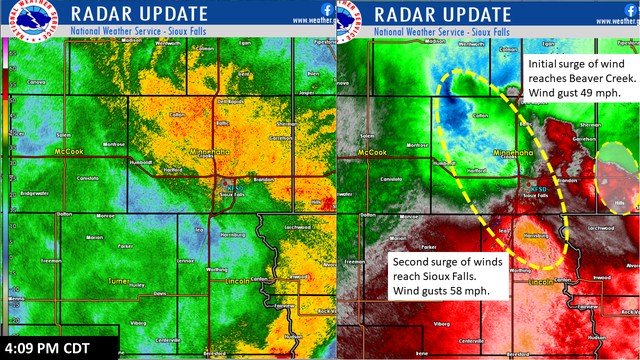
Evolution of strong winds around Sioux Falls
 |
 |
 |
 |
| 330 PM CDT; The leading edge of the derecho reaches the west side of Sioux Falls. Winds gust up to 48 mph at Sioux Falls Airport. Meanwhile, strong winds are in Montrose and approaching Humboldt. Winds in Montrose are gusting over 70 mph. | 409 PM: The second surge of winds reaches Sioux Falls. Winds had decreased to less than 30 mph but at 409 PM gusted up to 58 mph - strong than at the leading edge of the line. Meanwhile, the leading edge of storm reaches Beaver Creek, MN which gusts to 49 mph. | 440 PM: The strongest winds reach Sioux Falls as the airport gusts to 80 mph. At this point, winds have been gusting over 58 mph for 31 minutes. The second surge of winds also reaches Beaver Creek which gusts to 65 mph. | 500 PM: The strong winds and heavy rain move east of Sioux Falls with the gusts at the airport dropping below 50 mph. Wind gusted over 58 mph for 51 minutes. In Beaver Creek, the winds have peaked with a wind gust of 83 mph. Winds would remain over 60 mph for another 15 minutes. |
Storm Reports
 |
 |
| Map of where warnings were issued on July 5 | A map showing the location of storm reports on July 5 |
Report Time County Location Event Type (Magnitude)
2022-07-05 1:20 PM Jerauld 13 WNW Wessington Sprin SD TSTM WND GST (60 mph)
2022-07-05 1:30 PM Jerauld 2 ESE Wessington Spring SD TSTM WND GST (64 mph)
2022-07-05 1:35 PM Aurora 8 N Plankinton SD TSTM WND GST (65 mph)
2022-07-05 1:37 PM Charles Mix 14 W Platte SD TSTM WND GST (63 mph)
2022-07-05 1:40 PM Beadle Wolsey SD TSTM WND GST (70 mph)
2022-07-05 1:40 PM Beadle 3 NNW Wolsey SD TSTM WND GST (78 mph)
2022-07-05 1:50 PM Jerauld 1 W Lane SD TSTM WND GST (66 mph)
2022-07-05 2:03 PM Beadle 2 NNW Huron SD TSTM WND GST (96 mph)
2022-07-05 2:05 PM Sanborn 4 ESE Forestburg SD TSTM WND GST (59 mph)
2022-07-05 2:05 PM Douglas 3 S Corsica SD TSTM WND GST (60 mph)
2022-07-05 2:10 PM Gregory 1 WSW Fairfax SD TSTM WND GST (63 mph)
2022-07-05 2:10 PM Sanborn Woonsocket SD TSTM WND GST (80 mph)
2022-07-05 2:24 PM Gregory 2 WSW Pickstown SD TSTM WND GST (67 mph)
2022-07-05 2:27 PM Hutchinson 2 NW Tripp SD TSTM WND GST (59 mph)
2022-07-05 2:28 PM Davison 3 N Mitchell SD TSTM WND GST (63 mph)
2022-07-05 2:30 PM Jerauld 1 W Lane SD TSTM WND GST (70 mph)
2022-07-05 2:30 PM Beadle Cavour SD TSTM WND GST (80 mph)
2022-07-05 2:38 PM Sanborn 4 ESE Forestburg SD TSTM WND GST (81 mph)
2022-07-05 2:42 PM Beadle 3 E Cavour SD TSTM WND GST (65 mph)
2022-07-05 2:50 PM Bon Homme 6 NE Tyndall SD TSTM WND GST (60 mph)
2022-07-05 2:52 PM Davison 3 N Mitchell SD TSTM WND GST (75 mph)
2022-07-05 2:55 PM Bon Homme 5 ESE Tyndall SD TSTM WND GST (64 mph)
2022-07-05 3:00 PM Mccook 3 E Spencer SD TSTM WND GST (80 mph)
2022-07-05 3:06 PM Miner 1 WSW Howard SD TSTM WND DMG
2022-07-05 3:15 PM Mccook 2 W Salem SD TSTM WND GST (78 mph)
2022-07-05 3:16 PM Miner 1 W Howard SD TSTM WND GST (99 mph)
2022-07-05 3:20 PM Hanson 4 ENE Alexandria SD TSTM WND GST (76 mph)
2022-07-05 3:20 PM Mccook 1 NE Salem SD TSTM WND DMG
2022-07-05 3:20 PM Yankton 2 NE Yankton SD TSTM WND GST (59 mph)
2022-07-05 3:22 PM Bon Homme Springfield SD TSTM WND GST (77 mph)
2022-07-05 3:28 PM Yankton 2 WSW Gayville SD TSTM WND GST (65 mph)
2022-07-05 3:30 PM Lincoln 4 NNE Tea SD HAIL (1")
2022-07-05 3:30 PM Miner 1 W Howard SD TSTM WND GST (67 mph)
2022-07-05 3:35 PM Lincoln 4 SW Sioux Falls SD HAIL (1")
2022-07-05 3:36 PM Hutchinson 3 SSW Dolton SD TSTM WND GST (59 mph)
2022-07-05 3:37 PM Mccook Montrose SD TSTM WND GST (60 mph)
2022-07-05 3:53 PM Minnehaha Wall Lake SD TSTM WND GST (85 mph)
2022-07-05 3:59 PM Murray 1 E Lake Wilson MN HAIL (2.75")
2022-07-05 4:03 PM Lincoln 5 SSW Worthing SD TSTM WND GST (60 mph)
2022-07-05 4:08 PM Turner 3 ESE Parker SD TSTM WND GST (79 mph)
2022-07-05 4:25 PM Minnehaha 2 ESE Colton SD TSTM WND GST (62 mph)
2022-07-05 4:28 PM Union 3 SE Jefferson SD TSTM WND GST (64 mph)
2022-07-05 4:32 PM Union 3 SE Jefferson SD TSTM WND GST (65 mph)
2022-07-05 4:32 PM Lincoln 5 SSW Worthing SD TSTM WND GST (66 mph)
2022-07-05 4:33 PM Minnehaha 3 NNW Sioux Falls SD TSTM WND GST (80 mph)
2022-07-05 4:42 PM Rock 1 WSW Beaver Creek MN TSTM WND GST (73 mph)
2022-07-05 4:51 PM O'Brien Sanborn IA TSTM WND DMG
2022-07-05 4:52 PM Woodbury 2 SW Sergeant Bluff IA TSTM WND GST (59 mph)
2022-07-05 4:59 PM O'Brien 5 W Hartley IA TSTM WND GST (79 mph)
2022-07-05 5:05 PM Rock 1 WSW Magnolia MN TSTM WND GST (64 mph)
2022-07-05 5:15 PM Cottonwood Mountain Lake MN TSTM WND DMG
2022-07-05 5:29 PM Buena Vista Storm Lake IA TSTM WND GST (50 mph)
2022-07-05 5:30 PM Lyon 6 E Rock Rapids IA TSTM WND GST (64 mph)
2022-07-05 5:30 PM Rock Luverne MN FLASH FLOOD
2022-07-05 6:00 PM Minnehaha Garretson SD FLASH FLOOD
2022-07-05 6:00 PM Cottonwood 9 N Westbrook MN FLASH FLOOD
2022-07-05 6:14 PM O'Brien 4 E Sanborn IA TSTM WND GST 60 mph)
2022-07-05 6:30 PM Clay Royal IA TSTM WND DMG
Additional Information
SPC Outlooks
 |
 |
 |
 |
| SPC Day 3 Categorical Outlook | SPC Day 2 Categorial Outlook | SPC Day 1 Categorical Outlook | SPC Severe Thunderstorm Watch #436 |
 |
 |
 |
 |
| SPC Severe Thunderstorm Watch #436 | WPC Day 1 Excessive Rainfall Outlook | SPC Day 1 Hail Outlook | SPC Day 1 Wind Outlook |
Summaries from other NWS Offices
 |
Media use of NWS Web News Stories is encouraged! Please acknowledge the NWS as the source of any news information accessed from this site. |
|


 Weather Story
 Weather Map
 Local Radar
 Follow us on YouTube