Overview
|
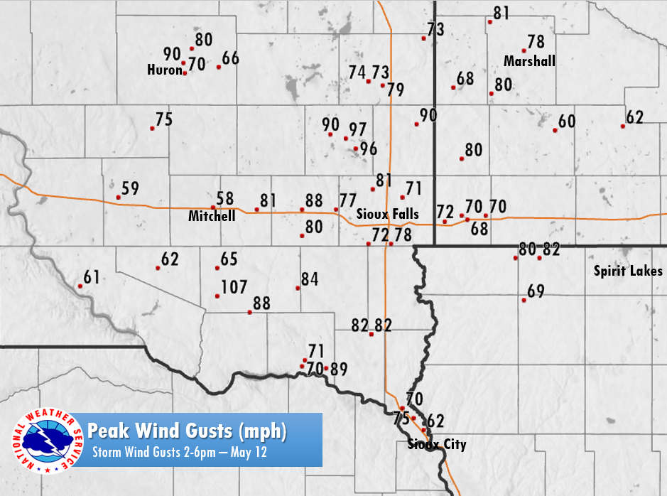
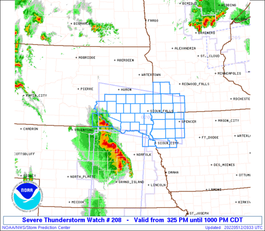
During the afternoon and evening hours of May 12, 2022, a strong line of thunderstorms developed across southern Nebraska and quickly raced northeast. As these storms moved north, they produced extreme winds across portions of the Northern Plains. Widespread straight-line winds between 50 and 70 mph were reported, with smaller areas of 80 to 100 mph winds. The highest wind gusts reported included a measured 107 mph gust in Tripp, SD, 97 mph wind gust in Madison, SD and a 90 mph wind gust in Huron, SD. The environment these storms developed in, led to the issuance of a "Particularly Dangerous Situation" (PDS) severe thunderstorm watch for much of the Sioux Falls forecast area. This was the first "PDS Watch" issued for any part of the Sioux Falls forecast office since 2015, and the largest PDS Watch issued since 2008. |
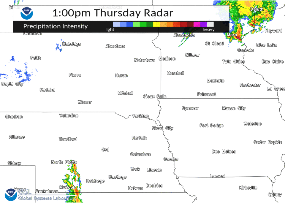 May 12 Derecho - Part 1 |
 |
 |
 |
| Peak Wind Gusts (MPH) | Severe Weather Reports | Severe Weather Warnings |
Wind & Hail:
Wind
This derecho brought two rounds of severe weather and strong winds across the region. The maps below show a combination of all peak wind reports from observation equipment and observer estimates, along with a breakout of peak wind reports during each severe weather episode.
|
 |
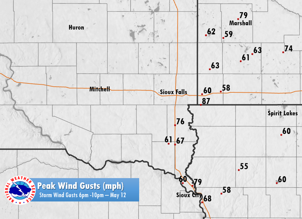 |
| All Peak Wind Reports | Peak Wind Reports (2 to 630PM) | Peak Wind Reports (6 pm to 10pm) |
Text Listing of Peak Wind Gusts
The included table indicates all the peak wind reports from the maps above.
|
||||||||||||||||||||||||||||||||||||||||||||||||||||||||||||||||||||||||||||||||||||||||||||||||||||||||||||||||||||||||||||||||||||||||||||||||||||||||||||||||||||||||||||||||||||||||||||||||||||||||||||||||||||||||||||||||||||||||||||||||||||||||||||||||||||||||||||||||||||||||||||||||||||||||||||||||||||||||||||||||||||||||||||||||||||||||||||||||||||||||||||||||||||||||||||||||||||||||||||||||||||||||||||||||||||||||||||||||||||||||||||||||||||||||||||||||||||||||||||||||||||||||||||||||||||||||||||||||||
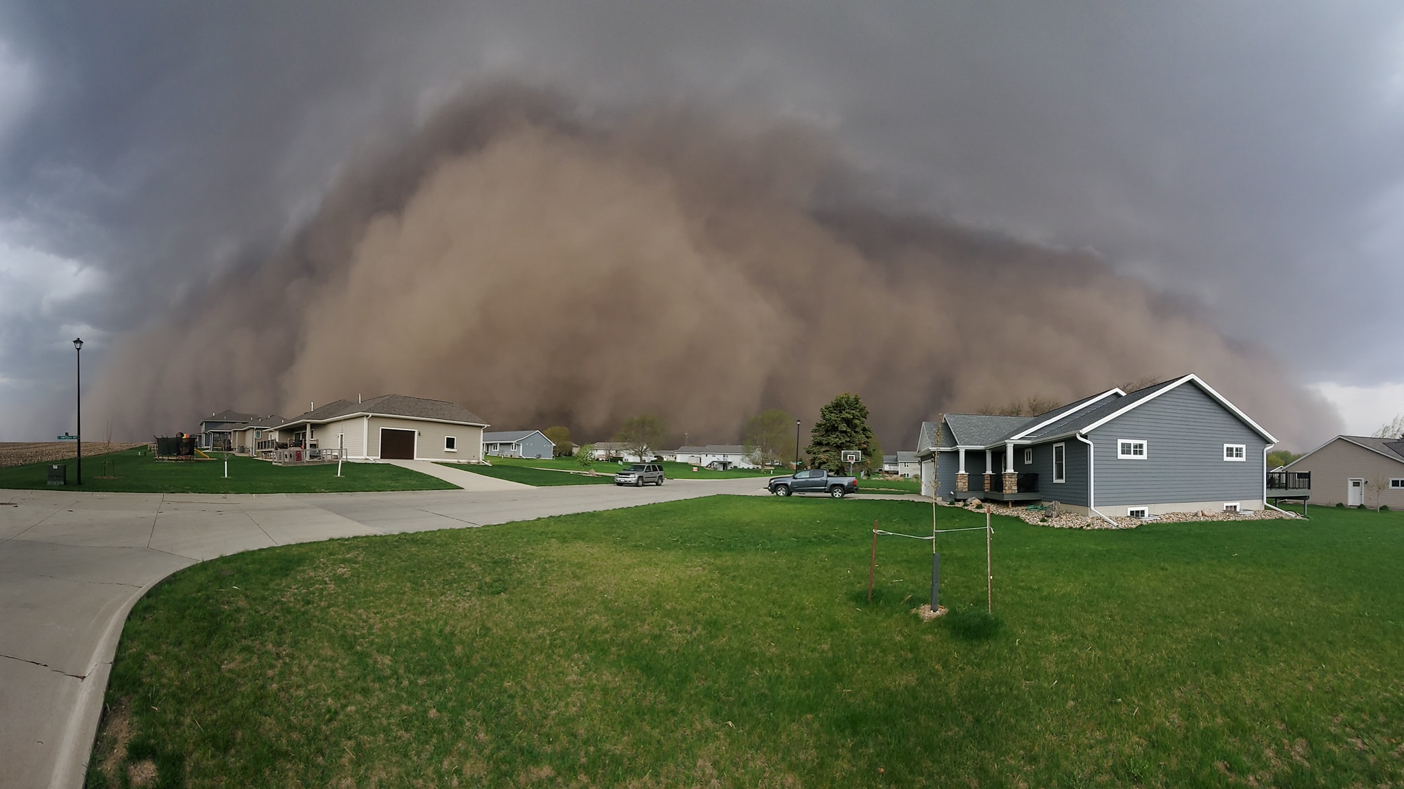
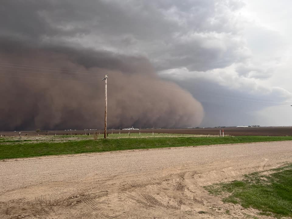
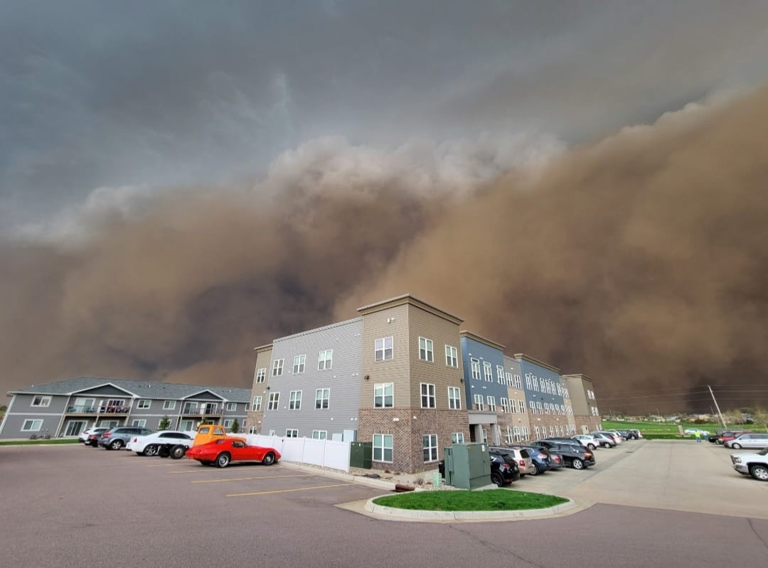
Photos & Video
Photos of the Haboob Ahead of the Derecho
 |
 |
 |
 |
| View of Storm from Rock Rapids, IA (source: Scott Stuerman) |
View of Storm from Hartford, SD (source: Deb Adams Johnson) |
View of Storm from Boyden, IA (source: Ryan Reiser) |
View of Storm from Colman, SD (source: Adam Martin) |
|
|
 |
 |
| View of Storm from I-90 MM 358 (source: Austin Barber) |
View of Storm near Colman (source: Adam Martin) |
View of Storm from Sioux Falls (source: Rayce Monahan) |
View of Storm from FSD Airport (source: NWS Sioux Falls) |
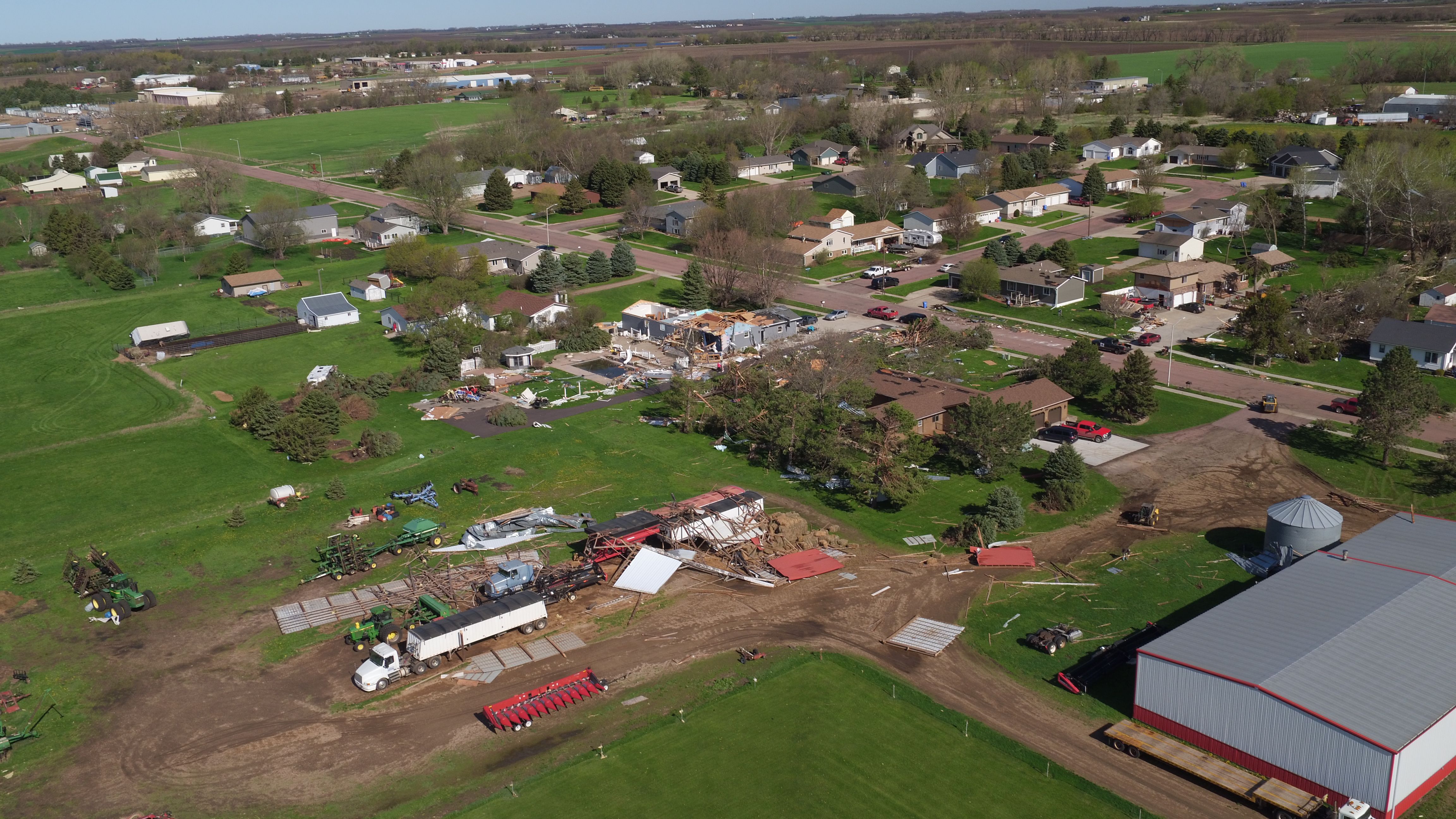
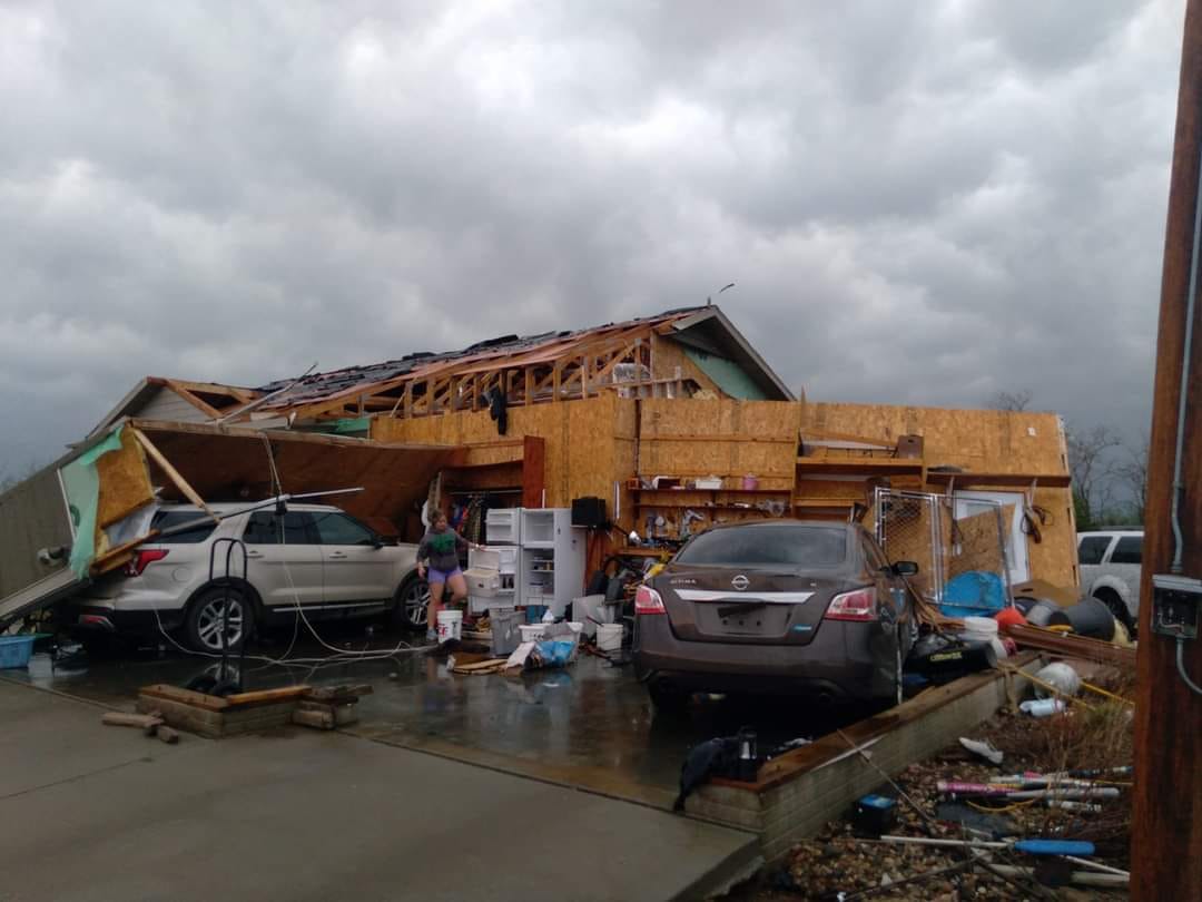
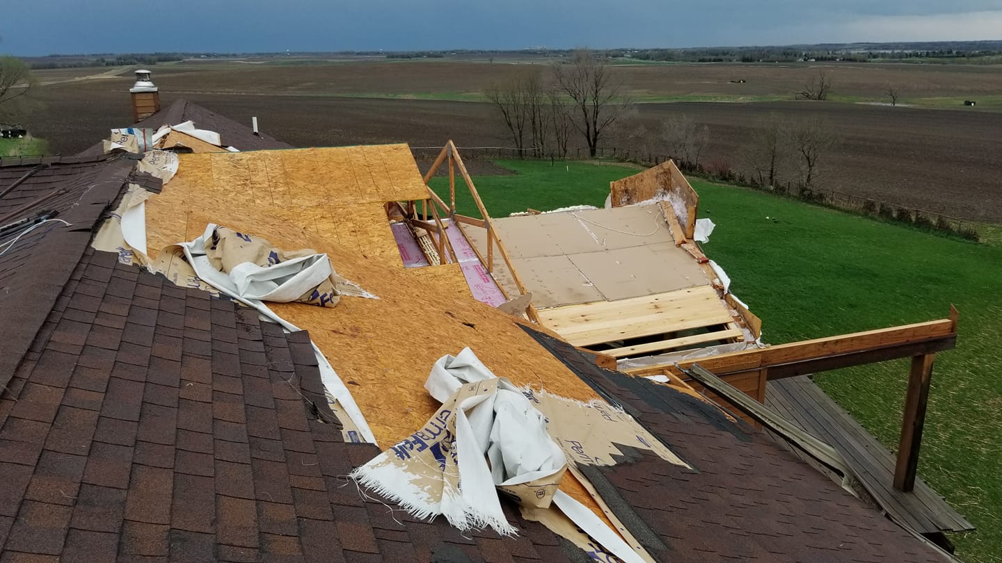
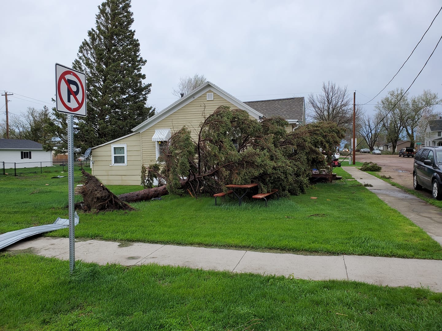
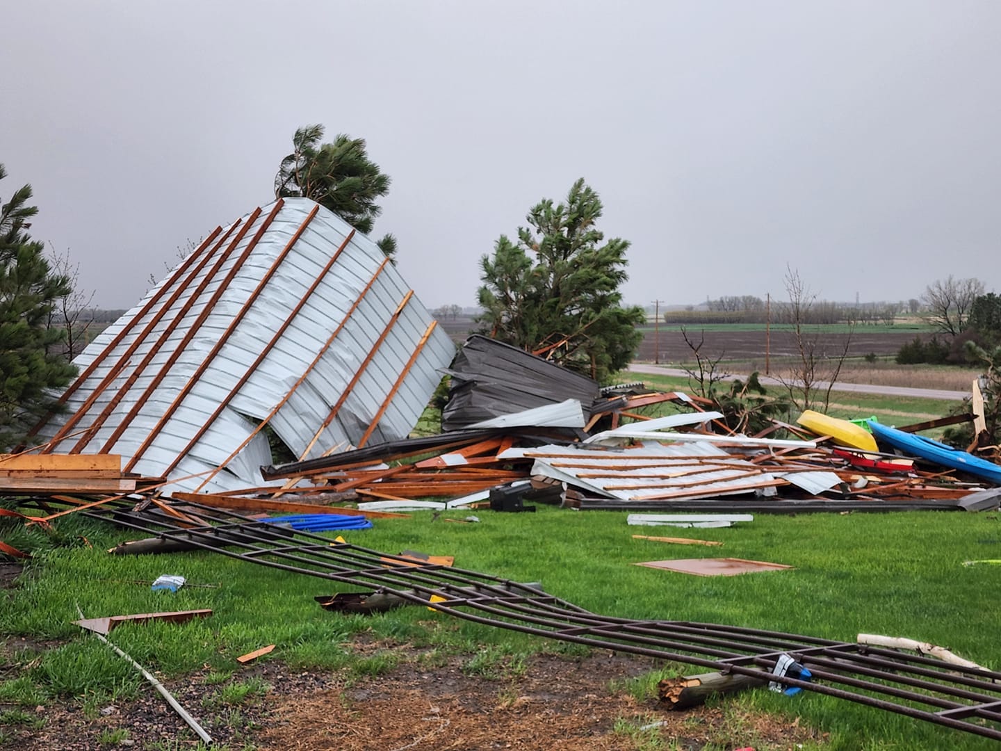
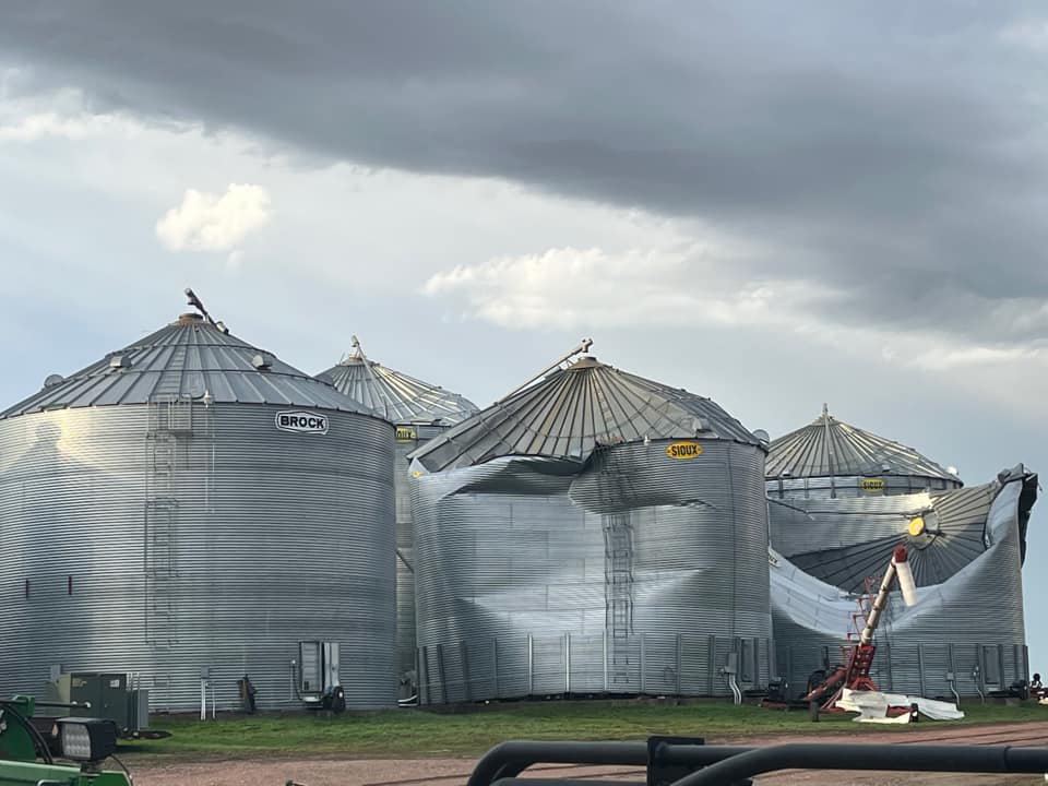
Damage From Around The Area
 |
 |
 |
 |
| Rock Valley, IA (source: Kyle Post) |
Madison, SD (source: Mathew Wollmann) |
Lake Benton, MN (source: Cara Bloom Bressler) |
Salem, SD (source: Steve Mehlbrech) |
 |
 |
 |
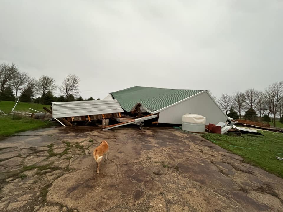 |
| Madison, SD (source: Abbie Ouverson) |
Coleman, SD (source: Julie KuehlBaumberger) |
Salem, SD (source: Mary Williams) |
Cottonwood, MN
(source: Chase Thompson) |
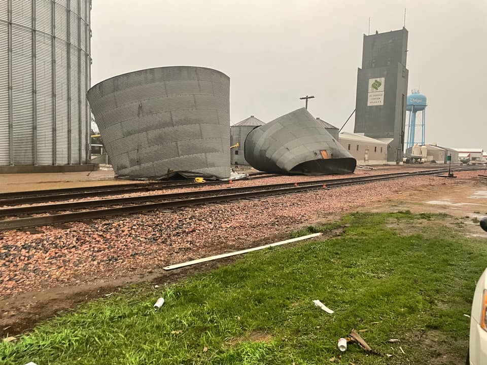 |
 |
 |
 |
| Volga, SD (source: Sheri Forrette) |
Tripp, SD (source: Brent Woods) |
Hartford, SD (source: Chad Madsen) |
Dell Rapids, SD (source: Jeff LeBrun) |
Header
| Caption (source) |
Caption (source) |
Caption (source) |
Caption (source) |
Radar
Radar Overview
 |
|
|
| 10 Minute Overview - Round 1 | ||
 |
||
| Event Radar Loop - 1 Hour Time Frame | 10 Minute Overview - Round 2 | |
Header
| Caption | Caption | Caption | Caption |
Header
| Caption | Caption | Caption | Caption |
Header
| Caption | Caption | Caption | Caption |
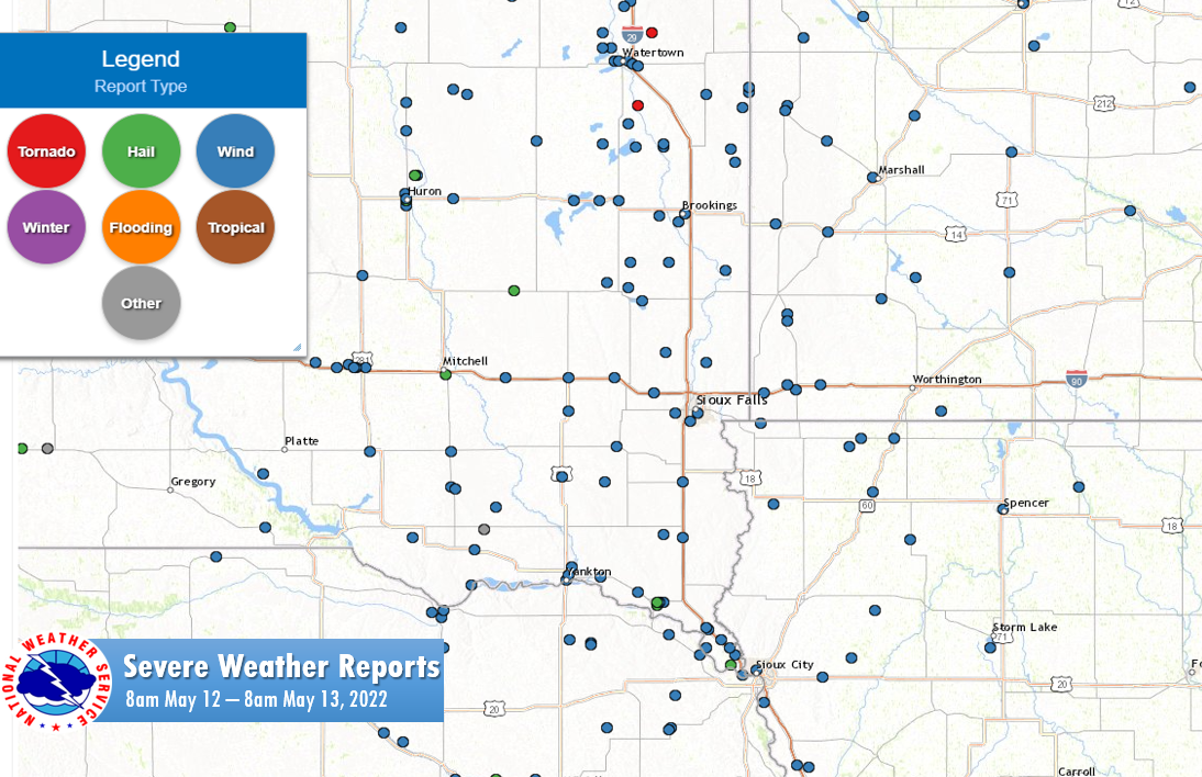
Storm Reports
Insert storm reports here. Copy in PNS or paste map.
|
| A Series of Maps Depicting Local Storm Reports |
 |
| A Summarized Listing of Local Storm Reports |
PRELIMINARY LOCAL STORM REPORT...SUMMARY
NATIONAL WEATHER SERVICE SIOUX FALLS SD
322 PM CDT FRI MAY 13 2022
..TIME... ...EVENT... ...CITY LOCATION... ...LAT.LON...
..DATE... ....MAG.... ..COUNTY LOCATION..ST.. ...SOURCE....
..REMARKS..
0749 PM TSTM WND GST 3 WSW LAKESIDE 42.60N 95.22W
05/12/2022 M60 MPH BUENA VISTA IA AWOS
AWOS STATION KSLB STORM LAKE AIRPORT.
0741 PM TSTM WND GST 5 S MARCUS 42.75N 95.81W
05/12/2022 E55 MPH CHEROKEE IA TRAINED SPOTTER
0534 PM TSTM WND DMG 4 SW LITTLE ROCK 43.40N 95.94W
05/12/2022 LYON IA PUBLIC
REPORT FROM MPING: TREES UPROOTED OR
SNAPPED; ROOF BLOWN OFF.
0800 PM TSTM WND DMG 4 S PRIMGHAR 43.03N 95.63W
05/12/2022 O'BRIEN IA PUBLIC
SIGNIFICANT ROOF DAMAGE TO LARGE MACHINE
SHED.
0555 PM TSTM WND GST 3 NE SIBLEY 43.43N 95.71W
05/12/2022 M82 MPH OSCEOLA IA MESONET
DELAYED REPORT. IOWA RWIS STATION RSYI4.
0730 PM TSTM WND DMG 2 SE KINGSLEY 42.56N 95.93W
05/12/2022 PLYMOUTH IA TRAINED SPOTTER
MACHINE SHED BLOWN OVER AND 2 TREES (6-8
INCH IN DIAMETER) SNAPPED.
0505 PM TSTM WND DMG 3 SW ROCK VALLEY 43.17N 96.33W
05/12/2022 SIOUX IA FIRE DEPT/RESCUE
ENTIRE ROOF AND ALL WALLS BLOWN OFF OF HOG
BARN, WITH DEBRIS SCATTERED FOR AT LEAST 3/4
OF A MILE DOWNSTREAM.
0613 PM TSTM WND DMG 3 SW ROCK VALLEY 43.17N 96.33W
05/12/2022 SIOUX IA PUBLIC
REPORT FROM MPING: HOMES/BUILDINGS
COMPLETELY DESTROYED.
0500 PM TSTM WND DMG 2 WNW SIOUX CITY 42.51N 96.42W
05/12/2022 WOODBURY IA BROADCAST MEDIA
LARGE BRANCHES AND POWER LINES DOWN.
0701 PM TORNADO 3 SSE SERGEANT BLUFF 42.36N 96.34W
05/12/2022 WOODBURY IA PUBLIC
VIDEO OF TORNADO CROSSING I-29 BETWEEN
SERGEANT BLUFF AND PORT NEAL.
0715 PM TSTM WND GST 1 SW MOVILLE 42.48N 96.08W
05/12/2022 M58 MPH WOODBURY IA MESONET
DELAYED REPORT. IOWA RWIS STATION RSCI4.
0901 PM TSTM WND GST 4 ENE JEFFERS 44.08N 95.12W
05/12/2022 M74 MPH COTTONWOOD MN MESONET
MESONET STATION MN071 MN-71 MILE POST 43.
0841 PM TSTM WND GST FLORENCE 44.24N 96.05W
05/12/2022 M59 MPH LYON MN MESONET
MN RWIS SITE.
0845 PM TSTM WND GST 1 WSW SLAYTON 43.98N 95.78W
05/12/2022 M61 MPH MURRAY MN AWOS
AWOS STATION KDVP SLAYTON MUNICIPAL AIRPORT.
0848 PM TSTM WND GST 3 W DOVRAY 44.06N 95.60W
05/12/2022 M63 MPH MURRAY MN MESONET
MESONET STATION MN038 DOVRAY MN-30 MILE POST
49.
0614 PM TSTM WND DMG ROUND LAKE 43.54N 95.47W
05/12/2022 NOBLES MN PUBLIC
REPORT FROM MPING: 1-INCH TREE LIMBS BROKEN;
SHINGLES BLOWN OFF.
0531 PM TSTM WND GST 2 NNW TROSKY 43.92N 96.26W
05/12/2022 M80 MPH PIPESTONE MN PUBLIC
MINNESOTA RWIS.
0519 PM TSTM WND GST 1 WSW BEAVER CREEK 43.61N 96.38W
05/12/2022 M72 MPH ROCK MN MESONET
MESONET STATION MN006 BEAVER CREEK I-90 MILE
POST 4.
0530 PM TSTM WND GST 1 WSW MAGNOLIA 43.64N 96.09W
05/12/2022 M70 MPH ROCK MN MESONET
DELAYED REPORT. MN RWIS SITE 950147.
0759 PM TSTM WND GST 1 WSW BEAVER CREEK 43.61N 96.38W
05/12/2022 M60 MPH ROCK MN MESONET
MESONET STATION MN006 BEAVER CREEK I-90 MILE
POST 4.
0814 PM TSTM WND GST 1 WSW MAGNOLIA 43.64N 96.09W
05/12/2022 M58 MPH ROCK MN PUBLIC
RWIS SITE.
0425 PM TSTM WND DMG NEWCASTLE 42.65N 96.87W
05/12/2022 DIXON NE LAW ENFORCEMENT
CORRECTS PREVIOUS TSTM WND DMG REPORT FROM
NEWCASTLE. MULTIPLE POWERLINES DOWN ACROSS
THE CITY. MULTIPLE BUILDINGS ALSO DOWN ALONG
HIGHWAY 12 NEAR MILE MARKER 219 AND 220.
0432 PM TSTM WND DMG PONCA 42.57N 96.71W
05/12/2022 DIXON NE LAW ENFORCEMENT
CORRECTS PREVIOUS TSTM WND DMG REPORT FROM
PONCA. MULTIPLE TREES AND POWERLINES DOWN.
0745 PM TSTM WND DMG 1 NNE WAKEFIELD 42.28N 96.86W
05/12/2022 DIXON NE LAW ENFORCEMENT
CORRECTS PREVIOUS TSTM WND DMG REPORT FROM
WAKEFIELD. MULTIPLE LARGE TREES DOWN.
0745 PM TSTM WND DMG WAKEFIELD 42.27N 96.87W
05/12/2022 DIXON NE LAW ENFORCEMENT
MULTIPLE LARGE TREES DOWN.
0755 PM TSTM WND DMG ALLEN 42.41N 96.84W
05/12/2022 DIXON NE LAW ENFORCEMENT
MULTIPLE TREES AND BRANCHES (3 INCH IN
DIAMETER) DOWN. BRANCH ALSO REPORTED DOWN ON
A POWERLINE.
0415 PM TSTM WND GST 1 ENE WHITE LAKE 43.73N 98.69W
05/12/2022 M59 MPH AURORA SD MESONET
MESONET STATION WTES2 WHITE LAKE (SD
MESONET).
0416 PM TSTM WND DMG 5 W PLANKINTON 43.71N 98.58W
05/12/2022 AURORA SD PUBLIC
12 VEHICLES FLIPPED ON I-90 BETWEEN WHITE
LAKE AND PLANKINTON.
0417 PM TSTM WND DMG PLANKINTON 43.71N 98.49W
05/12/2022 AURORA SD EMERGENCY MNGR
NUMEROUS POWER LINES DOWN DUE TO TREES
FALLING ON THEM IN THE CITY OF PLANKINTON,
WITH OTHER LARGE TREES DOWN THROUGHOUT THE
CITY.
0417 PM TSTM WND DMG 2 W PLANKINTON 43.72N 98.52W
05/12/2022 AURORA SD EMERGENCY MNGR
APPROXIMATELY 1/2 MILE OF POWER POLES WERE
SNAPPED, CAUSING THE ROAD TO CLOSE AS THE
POLES WERE ON THE HIGHWAY.
0417 PM TSTM WND DMG PLANKINTON 43.71N 98.48W
05/12/2022 AURORA SD EMERGENCY MNGR
VERY LARGE TREES UPROOTED AROUND TOWN.
0420 PM TSTM WND DMG 3 E PLANKINTON 43.71N 98.43W
05/12/2022 AURORA SD EMERGENCY MNGR
MASSIVE DAMAGE TO CHICKEN BARN.
0500 PM HAIL HURON 44.36N 98.22W
05/12/2022 E1.00 INCH BEADLE SD PUBLIC
0500 PM TSTM WND DMG HURON 44.37N 98.22W
05/12/2022 BEADLE SD TRAINED SPOTTER
NUMEROUS PINE TREES HAVE BEEN UPROOTED BY
THE WIND. POWER IS OUT ACROSS THE SOUTHERN
PART OF TOWN.
0510 PM HAIL 7 NNE HURON 44.46N 98.18W
05/12/2022 E0.88 INCH BEADLE SD EMERGENCY MNGR
0513 PM HAIL HURON 44.36N 98.22W
05/12/2022 M0.75 INCH BEADLE SD EMERGENCY MNGR
0410 PM TSTM WND DMG SPRINGFIELD 42.85N 97.89W
05/12/2022 BON HOMME SD PUBLIC
TRAINED SPOTTER REPORTS MULTIPLE BRANCHES
(ESTIMATED 2 FT IN DIAMETER) ON THE GROUND.
0412 PM TSTM WND DMG TYNDALL 42.99N 97.87W
05/12/2022 BON HOMME SD CO-OP OBSERVER
WINDS ESTIMATED 90-100 MPH IN TYNDALL. LOTS
OF TREE AND STRUCTURAL DAMAGE. COUNTY SHED
DESTROYED.
0526 PM TSTM WND DMG BROOKINGS 44.31N 96.79W
05/12/2022 BROOKINGS SD EMERGENCY MNGR
NUMEROUS VEHICLES KNOCKED OVER AND TREES
SNAPPED. WIDESPREAD DAMAGE TO HOUSES AND
ROOFS.
0415 PM TSTM WND DMG DANTE 43.04N 98.19W
05/12/2022 CHARLES MIX SD PUBLIC
AN 80 FOOT BY 200 FOOT BUILDING HAS ONLY ONE
WALL STANDING. A 42 FOOT BY 60 FOOT BUILDING
HAS ONLY ONE STANDING WALL REMAINING.
NUMEROUS TREES UPROOTED. ROOFS OFF
BUSINESSES.
0428 PM TSTM WND DMG 3 ESE MECKLING 42.82N 97.03W
05/12/2022 CLAY SD EMERGENCY MNGR
SEMI BLOWN OVER.
0430 PM TSTM WND DMG 1 ESE VERMILLION 42.78N 96.90W
05/12/2022 CLAY SD PUBLIC
REPORT FROM MPING: 3-INCH TREE LIMBS BROKEN;
POWER POLES BROKEN.
0455 PM TSTM WND DMG VERMILLION 42.78N 96.92W
05/12/2022 CLAY SD PUBLIC
REPORT FROM MPING: 1-INCH TREE LIMBS BROKEN;
SHINGLES BLOWN OFF.
0716 PM HAIL 1 SSW VERMILLION 42.77N 96.93W
05/12/2022 E0.70 INCH CLAY SD EMERGENCY MNGR
0719 PM HAIL VERMILLION 42.78N 96.93W
05/12/2022 U0.75 INCH CLAY SD PUBLIC
REPORT FROM MPING: DIME (0.75 IN.).
0720 PM HAIL 1 ENE VERMILLION 42.78N 96.92W
05/12/2022 M1.00 INCH CLAY SD PUBLIC
REPORT FROM MPING: QUARTER (1.00 IN.).
0725 PM HAIL 1 ENE VERMILLION 42.78N 96.92W
05/12/2022 M1.00 INCH CLAY SD PUBLIC
REPORT FROM MPING: QUARTER (1.00 IN.).
0731 PM TSTM WND GST 5 SSE CENTERVILLE 43.05N 96.90W
05/12/2022 M61 MPH CLAY SD MESONET
DELAYED REPORT. MESONET STATION BFMS2
BERESFORD 7 WSW (SDSU MESONET).
0432 PM TSTM WND GST 4 SSE MITCHELL 43.68N 98.02W
05/12/2022 M58 MPH DAVISON SD MESONET
MESONET STATION FW9779 MITCHELL.
0443 PM HAIL 4 SSE MITCHELL 43.68N 98.02W
05/12/2022 E0.50 INCH DAVISON SD PUBLIC
REPORT FROM MPING: HALF-INCH (0.50 IN.).
0330 PM TSTM WND DMG BONESTEEL 43.08N 98.95W
05/12/2022 GREGORY SD TRAINED SPOTTER
MULTIPLE 3 INCH BRANCHES DOWN.
0425 PM TSTM WND GST 2 NW TRIPP 43.24N 97.99W
05/12/2022 M107 MPH HUTCHINSON SD MESONET
MESONET STATION 26 SD RWIS TRIPP.
0523 PM TSTM WND DMG 1 S HETLAND 44.36N 97.23W
05/12/2022 KINGSBURY SD TRAINED SPOTTER
BARN DESTROYED WITH DEBRIS THROWN ACROSS
HIGHWAY 14.
0523 PM TSTM WND DMG 1 E LAKE PRESTON 44.36N 97.36W
05/12/2022 KINGSBURY SD TRAINED SPOTTER
7 TO 8 POWER POLES SNAPPED.
0525 PM TSTM WND DMG ARLINGTON 44.36N 97.13W
05/12/2022 KINGSBURY SD TRAINED SPOTTER
2 GRAIN SILO TOPS RIPPED OFF AND BENT IN,
PORTIONS OF ROOFS PEELED OFF DOWNTOWN, AND
MULTIPLE TREES DOWN ACROSS THE CITY.
0512 PM TSTM WND DMG 4 SW NUNDA 44.12N 97.07W
05/12/2022 LAKE SD TRAINED SPOTTER
5 LARGE TREES DOWN AND ROOF BLOWN OFF OF
BARN.
0500 PM TSTM WND DMG CANTON 43.30N 96.58W
05/12/2022 LINCOLN SD EMERGENCY MNGR
ROOF TORN OFF OF BUILDING.
0450 PM TSTM WND DMG 5 WNW CANISTOTA 43.63N 97.37W
05/12/2022 MCCOOK SD PUBLIC
1480 FOOT TV TOWER BUILT IN 1976 DOWNED BY
THUNDERSTORM WINDS.
0509 PM HAIL 2 ENE ROSWELL 44.01N 97.67W
05/12/2022 U0.75 INCH MINER SD PUBLIC
REPORT FROM MPING: DIME (0.75 IN.).
0456 PM TSTM WND DMG 1 SSW HARTFORD 43.61N 96.95W
05/12/2022 MINNEHAHA SD EMERGENCY MNGR
WINDOWS BLOWN OUT AND ROOF TORN OFF OF
COFFEE CUP FUEL TRUCK STOP.
0502 PM TSTM WND DMG 1 SSE SIOUX FALLS 43.53N 96.72W
05/12/2022 MINNEHAHA SD EMERGENCY MNGR
TREE DOWN ON HOUSE.
0503 PM TSTM WND DMG 5 W SIOUX FALLS 43.53N 96.84W
05/12/2022 MINNEHAHA SD PUBLIC
REPORT FROM MPING: 1-INCH TREE LIMBS BROKEN;
SHINGLES BLOWN OFF.
0509 PM TSTM WND DMG DELL RAPIDS 43.82N 96.71W
05/12/2022 MINNEHAHA SD PUBLIC
TREES DOWN AND DAMAGE TO OUTBUILDING AT HIGH
SCHOOL.
0511 PM TSTM WND DMG 1 SSW HARTFORD 43.61N 96.95W
05/12/2022 MINNEHAHA SD PUBLIC
REPORT FROM MPING: 3-INCH TREE LIMBS BROKEN;
POWER POLES BROKEN.
0512 PM TSTM WND DMG 2 SSW SIOUX FALLS 43.52N 96.74W
05/12/2022 MINNEHAHA SD PUBLIC
REPORT FROM MPING: 3-INCH TREE LIMBS BROKEN;
POWER POLES BROKEN.
0515 PM TSTM WND DMG 8 ESE NUNDA 44.12N 96.87W
05/12/2022 MOODY SD PUBLIC
LARGE AND MATURE TREES BENT OVER 30 DEGREES.
WINDS ESTIMATED 65 MPH.
0434 PM TSTM WND DMG 6 WSW HURLEY 43.26N 97.20W
05/12/2022 TURNER SD PUBLIC
CATTLE SHED IS HALF GONE, WITH NUMEROUS
PIECES SCATTERED ACROSS THE PROPERTY. WOODEN
SHED HAD TWO SMALL SLIDING DOOR RIPPED OFF.
BIG PINE TREE WAS LAID DOWN.
0453 PM TSTM WND DMG PARKER 43.40N 97.14W
05/12/2022 TURNER SD TRAINED SPOTTER
NUMEROUS TREES WERE KNOCKED DOWN BY THE
WIND, BLOCKING MANY STREETS. POWER IS OUT AT
MOST PLACES IN TOWN, ESPECIALLY THE
SOUTHWEST PART.
0433 PM DUST STORM 3 SSW BERESFORD 43.04N 96.80W
05/12/2022 UNION SD PUBLIC
VISIBILITY LESS THAN 100 FEET.
0506 PM TSTM WND DMG 1 SSE ELK POINT 42.67N 96.67W
05/12/2022 UNION SD PUBLIC
REPORT FROM MPING: 3-INCH TREE LIMBS BROKEN;
POWER POLES BROKEN.
0712 PM TSTM WND DMG 3 S NORTH SIOUX CITY 42.49N 96.49W
05/12/2022 UNION SD EMERGENCY MNGR
NUMEROUS SNAPPED POWERLINES AND TREES DOWN
THROUGHOUT DAKOTA DUNES.
0714 PM TSTM WND DMG JEFFERSON 42.60N 96.56W
05/12/2022 UNION SD EMERGENCY MNGR
NUMEROUS POWER LINES AND TREES DOWN
THROUGHOUT THE CITY OF JEFFERSON, SD.
0721 PM HAIL 3 WSW NORTH SIOUX CITY 42.53N 96.55W
05/12/2022 M0.75 INCH UNION SD PUBLIC
REPORT FROM MPING: DIME (0.75 IN.).
0425 PM TSTM WND DMG 1 SSW YANKTON 42.87N 97.40W
05/12/2022 YANKTON SD PUBLIC
REPORT VIA SOCIAL MEDIA OF MULTIPLE 3-4 INCH
LIMBS DOWN.
|
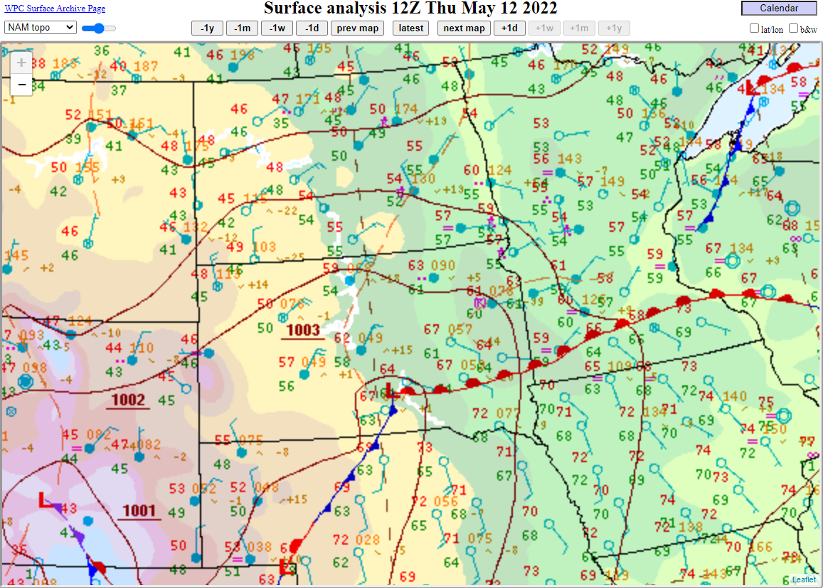
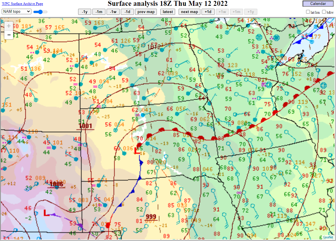
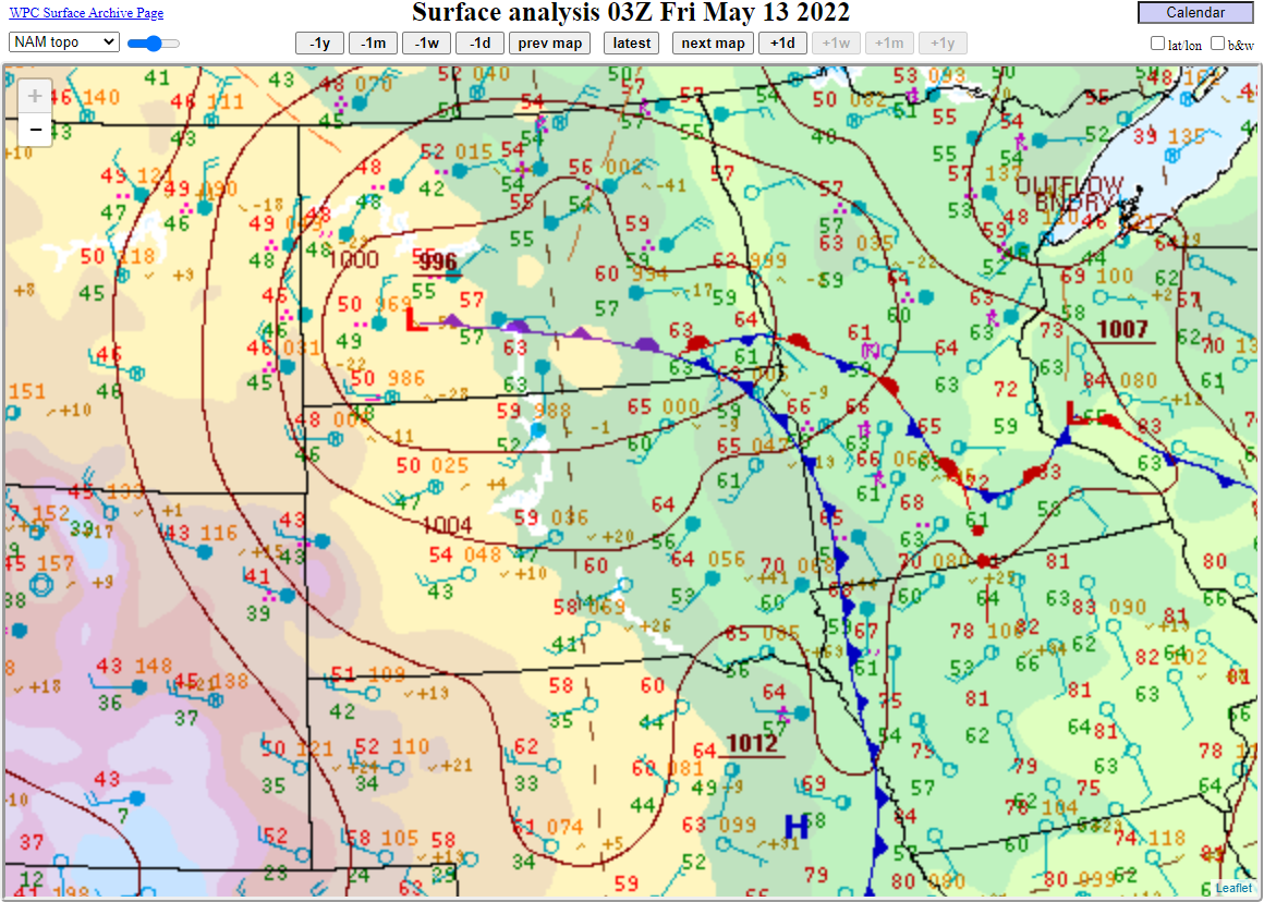
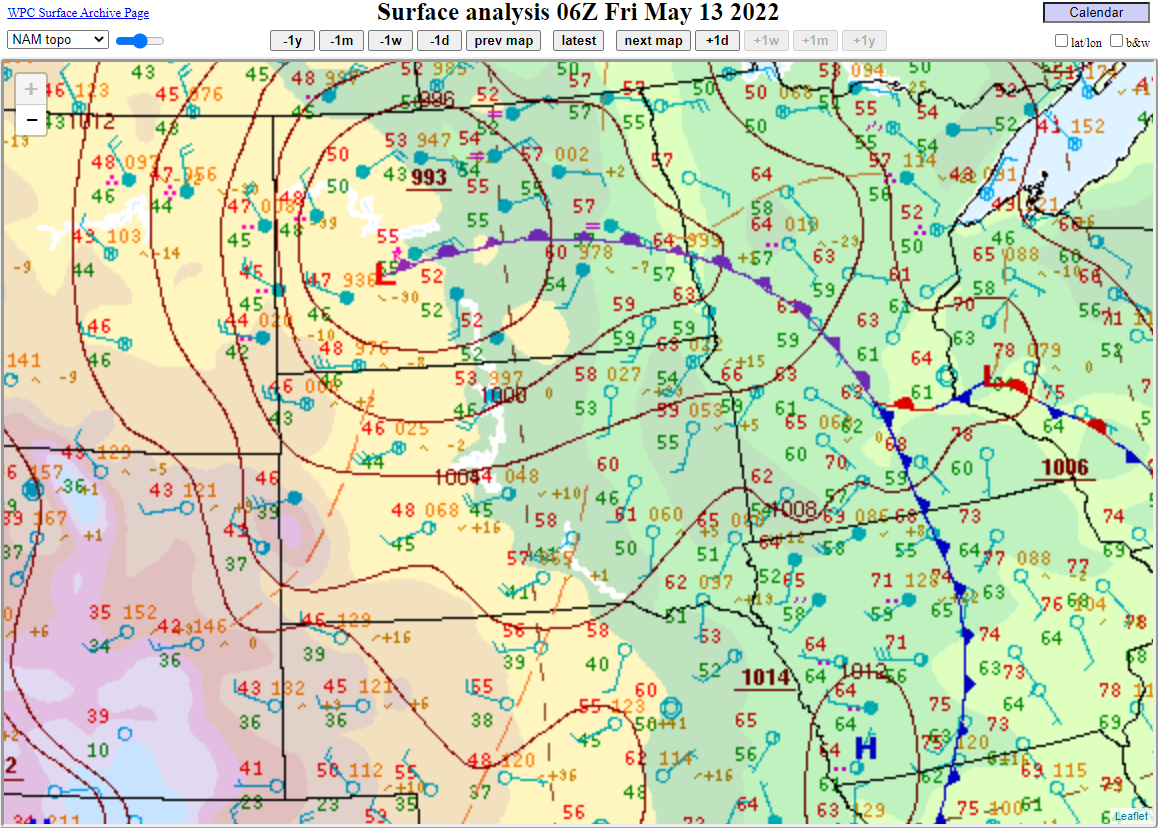
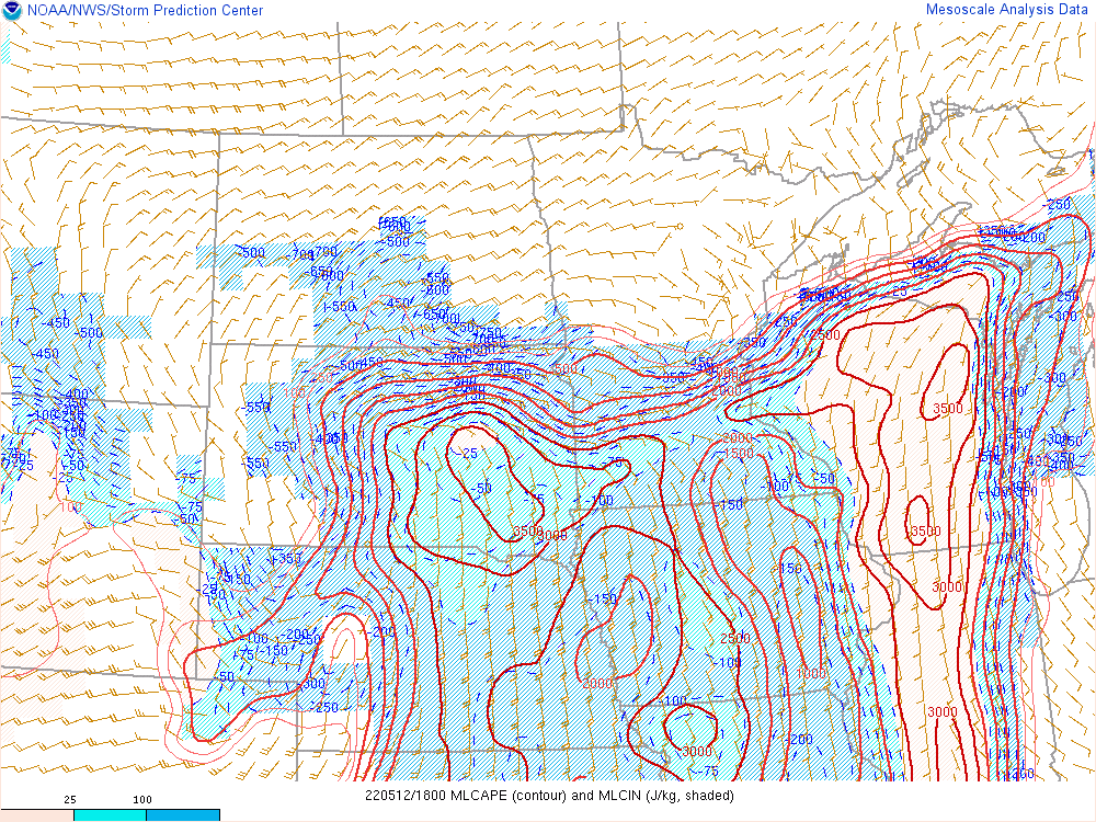
Environment
Here a look at the surface environment that brought record temperatures and dew points for the month into the area.
 |
 |
 |
|
| Surface map at 7am, showing a deep low pressure system taking shape. | Surface map at 10am, showing widespread cloud cover north of the warm front (filled in blue circles). | Surface map at 1pm, showing cool air north of the warm front and summer-like air south of it (temperatures in the 80s and dewpoints around 70 F) | Surface map at 4pm, showing the front lifting north, with a line of storms across the eastern SD/NE border. |
|
 |
 |
|
| Surface map at 7pm. Storms at this time were near or at the ND/SD border, along the warm front. | Surface map at 10pm, showing the low occluding and deepening. | Surface map at 1am, showing further deepening of the low, and strong surface winds. |
 |
 |
 |
.png) |
| 18Z MLCAPE | 21Z MLCAPE | 00Z MLCAPE | 03 MLCAPE |
 |
 |
 |
 |
| 18Z MUCAPE | 21Z MUCAPE | 00Z MUCAPE | 03 MUCAPE |
 |
 |
 |
|
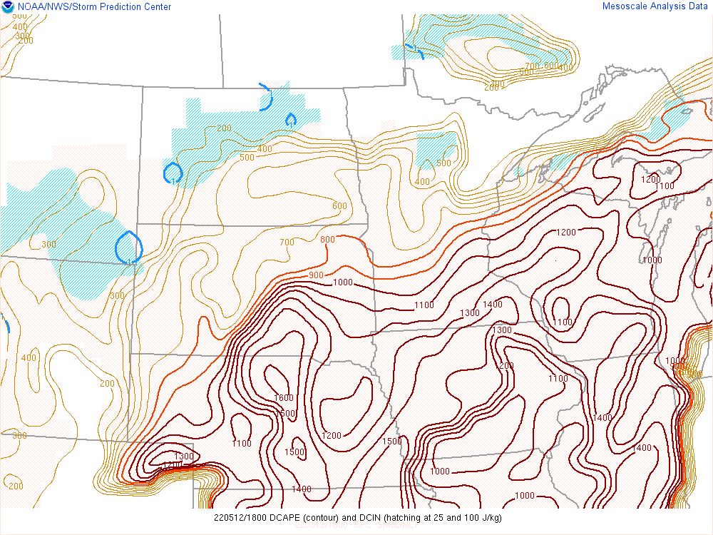
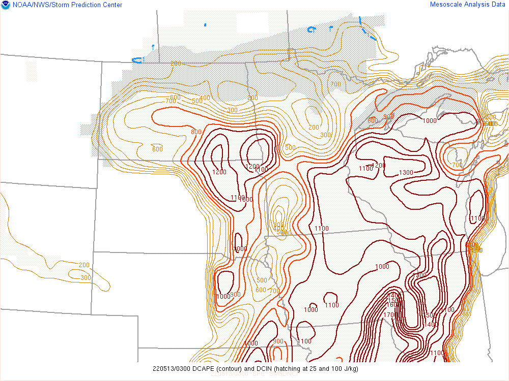
| 18Z DCAPE | 21Z DCAPE | 00Z DCAPE | 03Z DCAPE |
 |
 |
 |
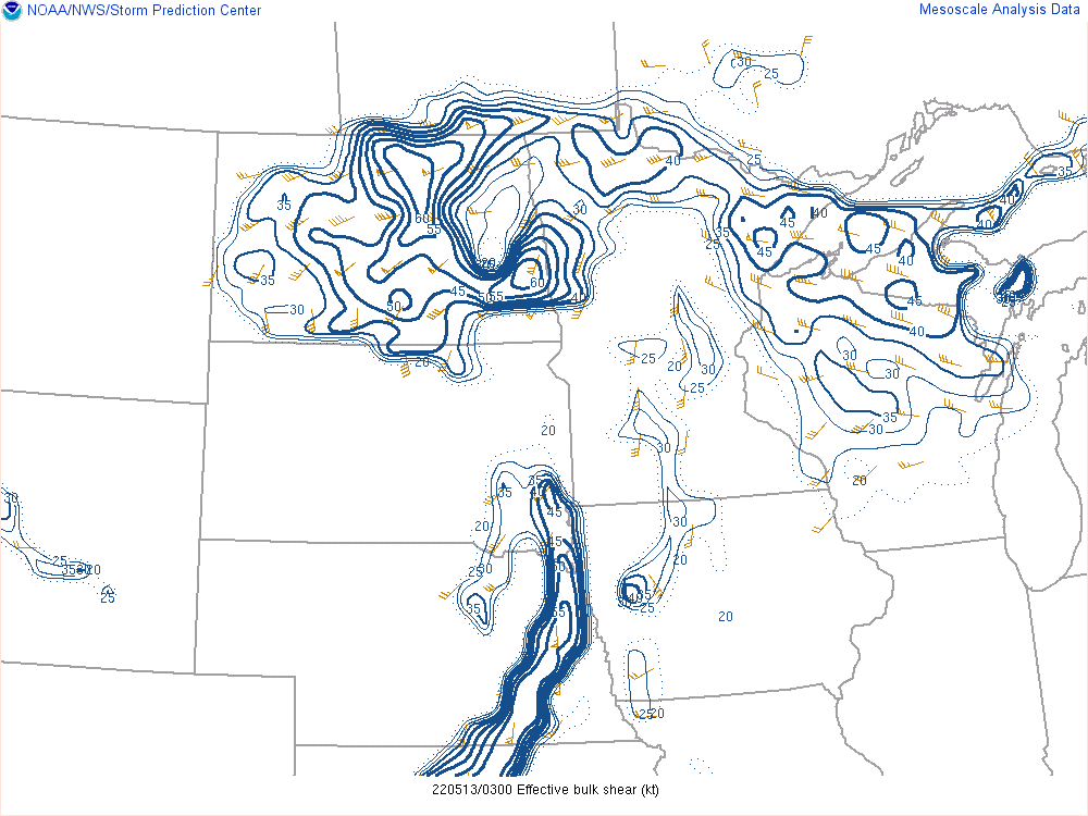 |
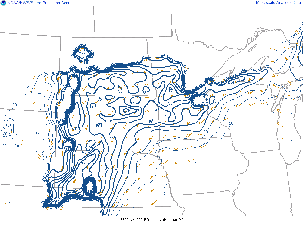
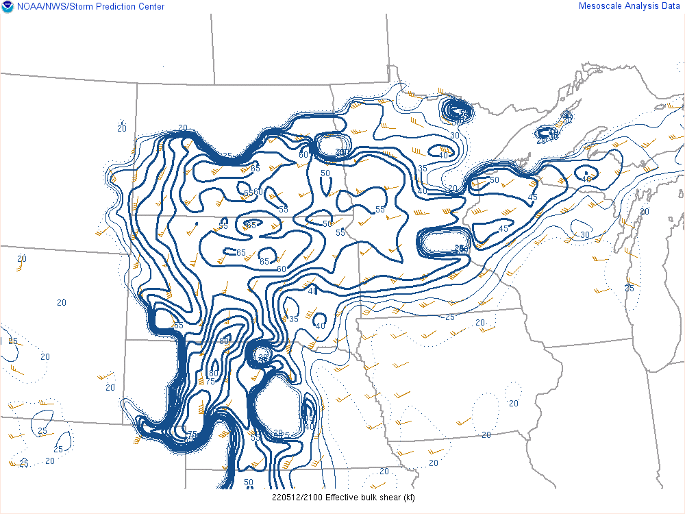
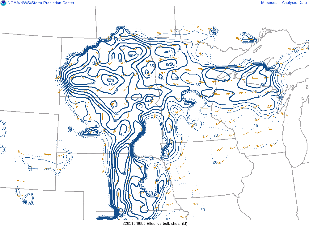
| 18Z Effective Shear | 21Z Effective Shear | 00Z Effective Shear | 03Z Effective Shear |
 |
 |
 |
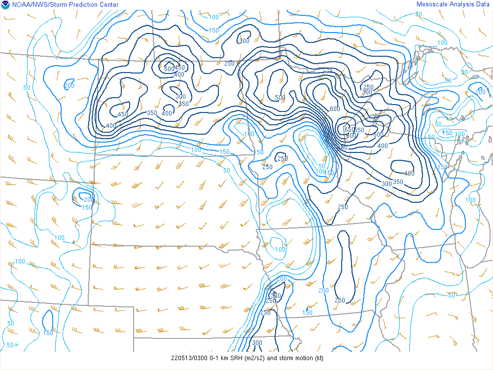 |
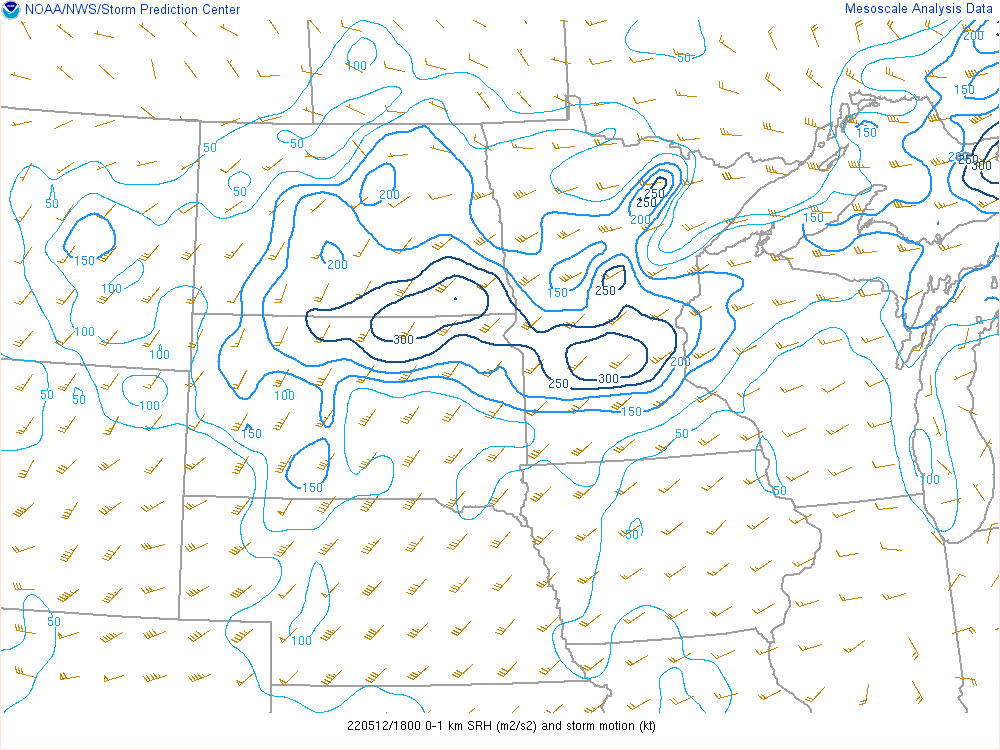
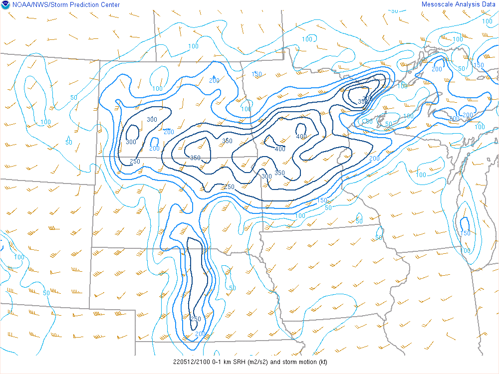
| 18Z 0-1KM Helicity | 21Z 0-1KM Helicity | 00Z 0-1KM Helicity | 03Z 0-1KM Helicity |
Synoptic Conditions
 |
 |
 |
 |
| 18Z 300 MB | 21,,Z 300 MB | 00Z 300 MB | 03Z 300 MB |
 |
 |
 |
 |
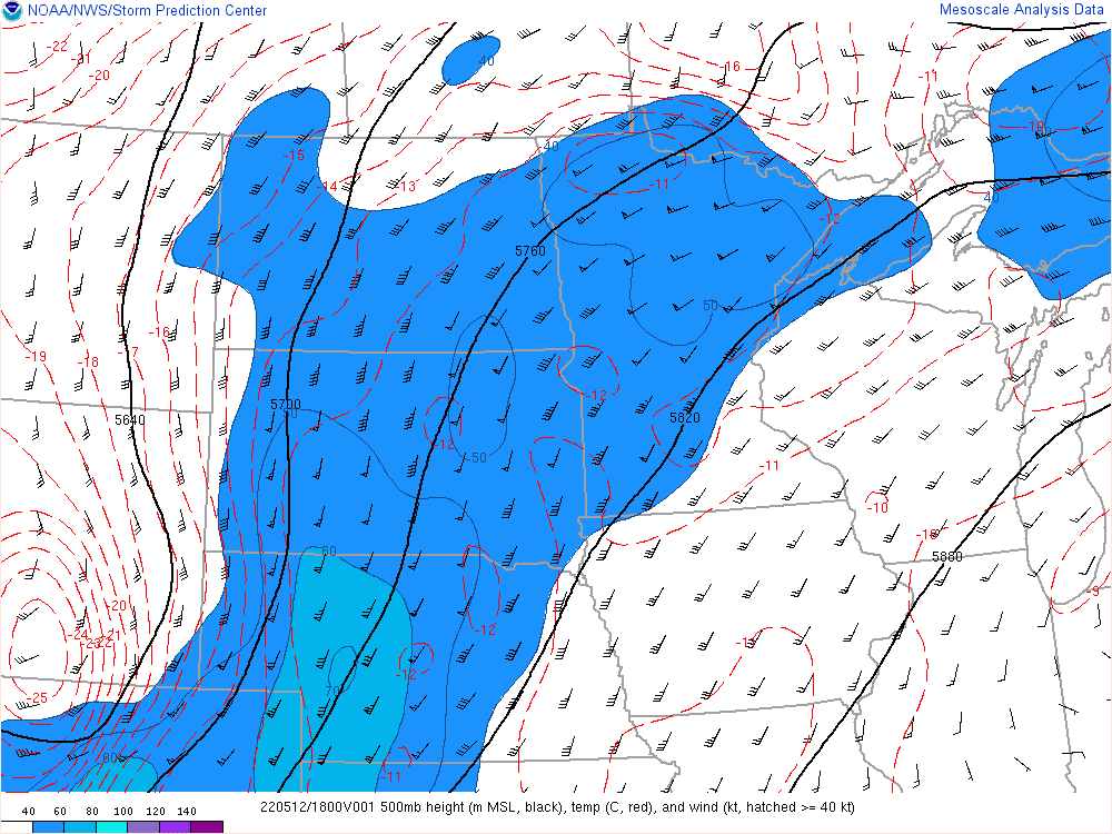
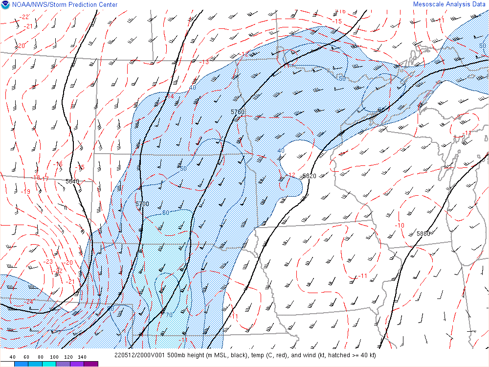
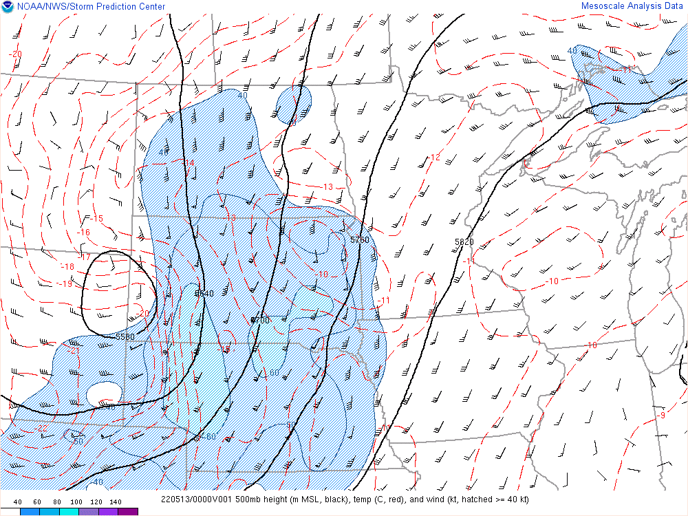
| 18Z 500 MB | 21Z 500 MB | 00Z 500 MB | 03Z 500 MB |
 |
 |
 |
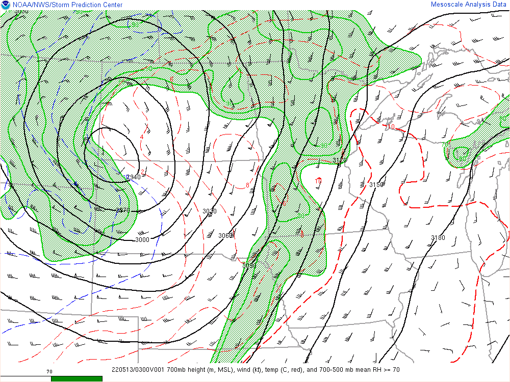 |
| 18Z 700 MB | 18Z 700 MB | 18Z 700 MB | 18Z 700 MB |
 |
 |
 |
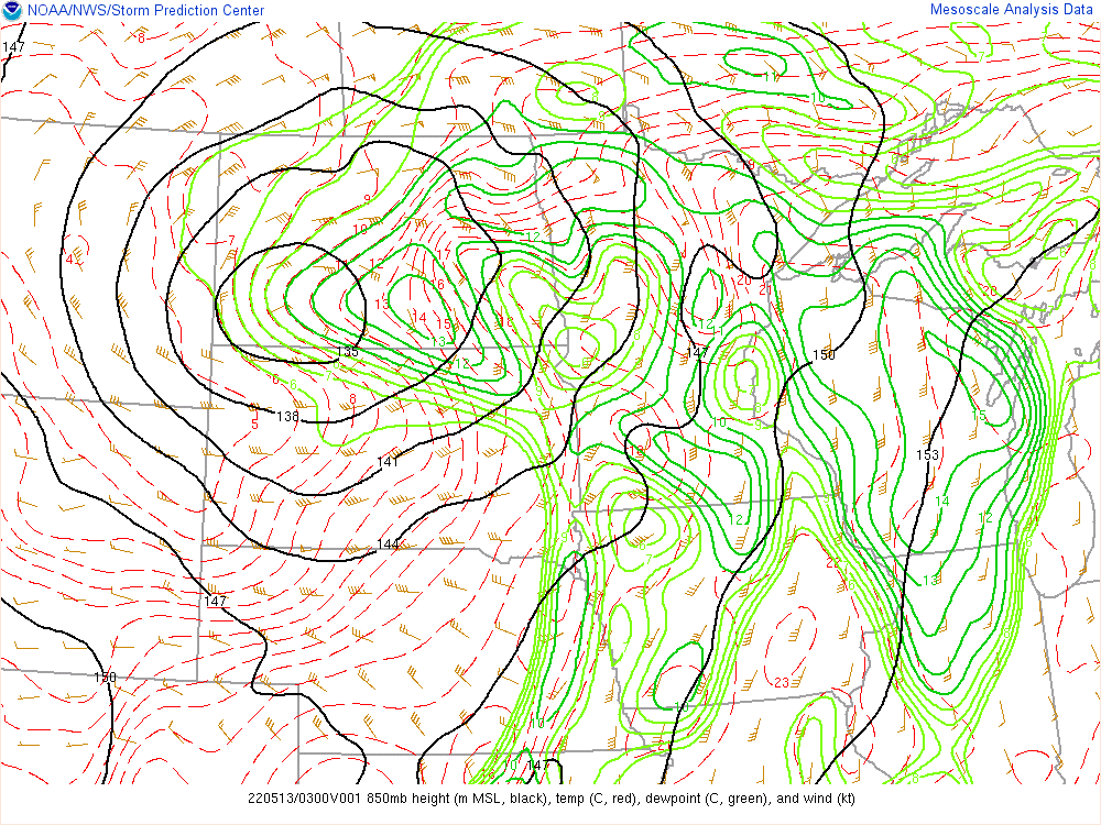 |
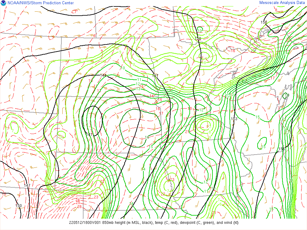
| 18Z 850 MB | 21Z 850 MB | 00Z 850 MB | 03Z 850 MB |
Other Composite Indices
 |
 |
|
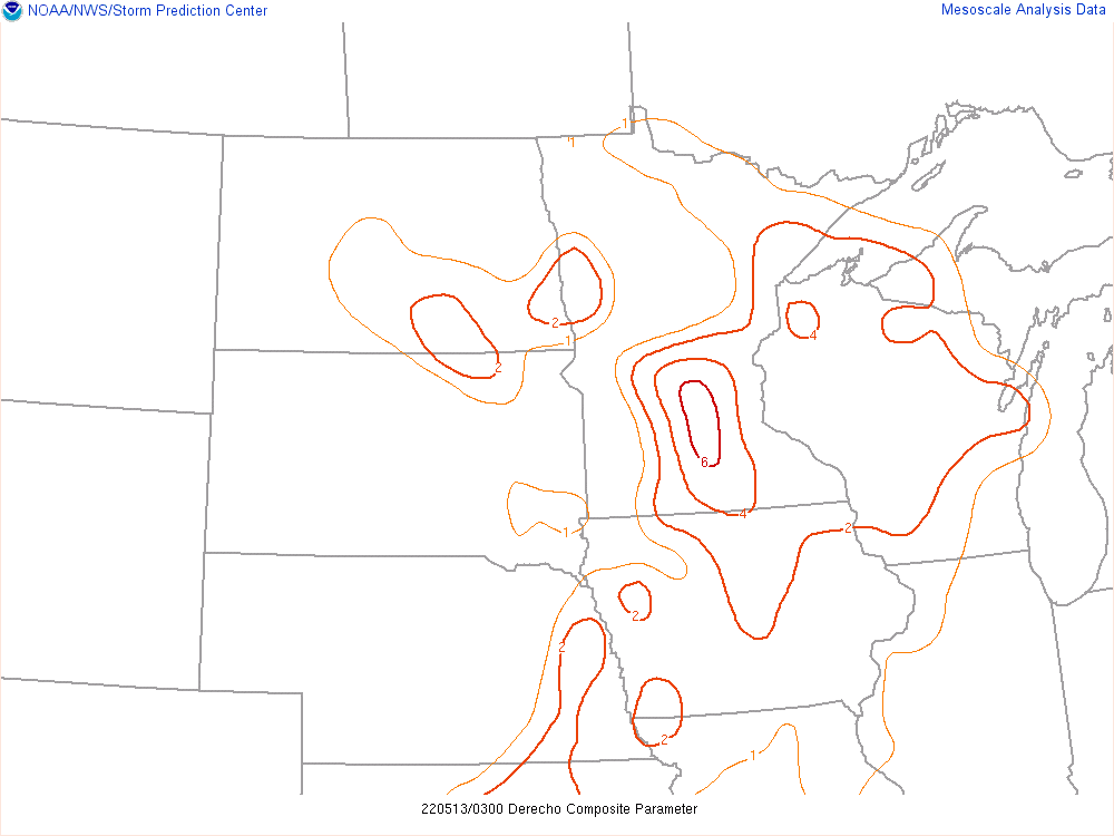 |
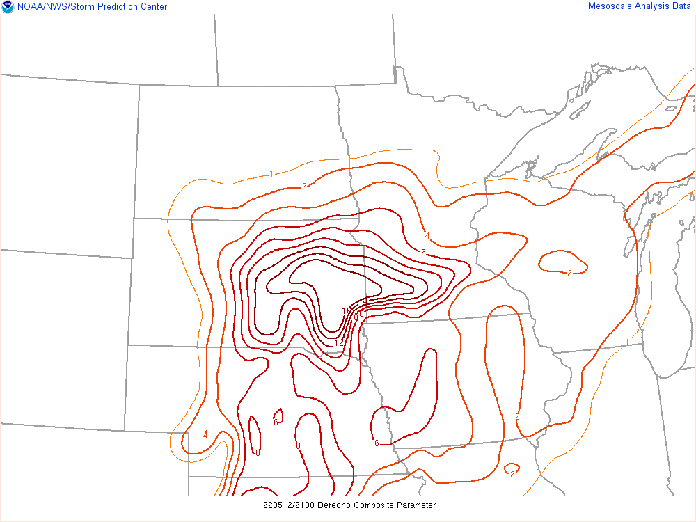
| 18Z Derecho Index | 21Z Derecho Index | 00Z Derecho Index | 03Z Derecho Index |
 |
 |
 |
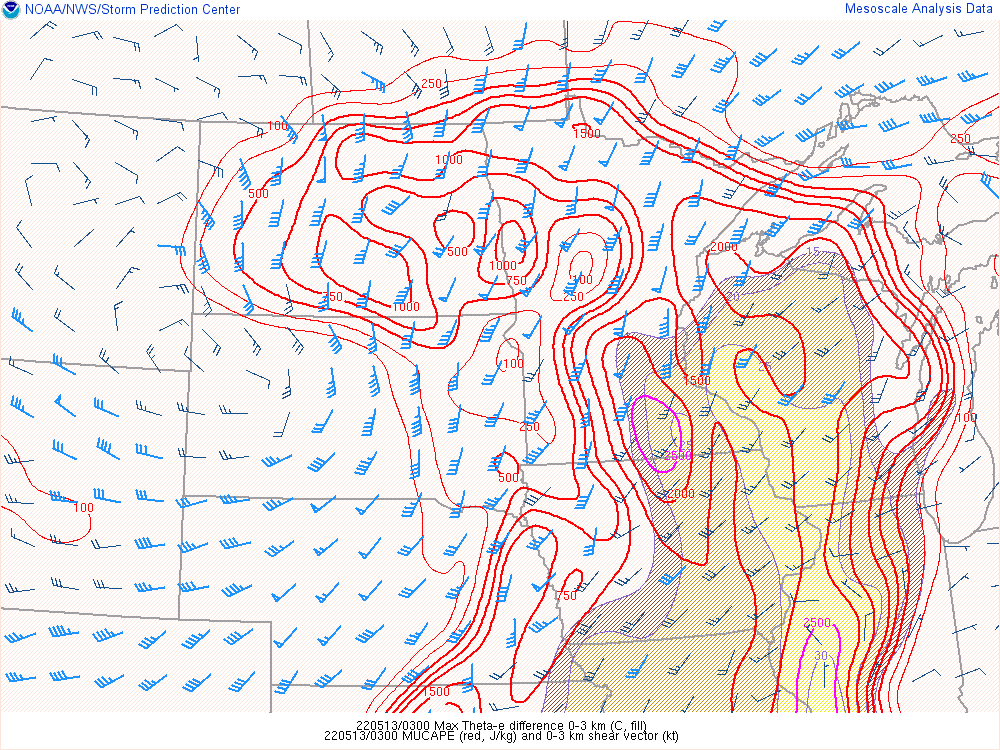 |
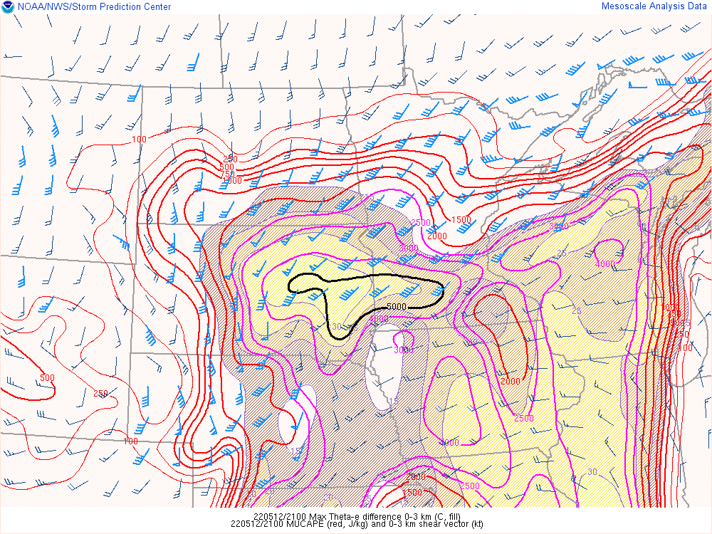
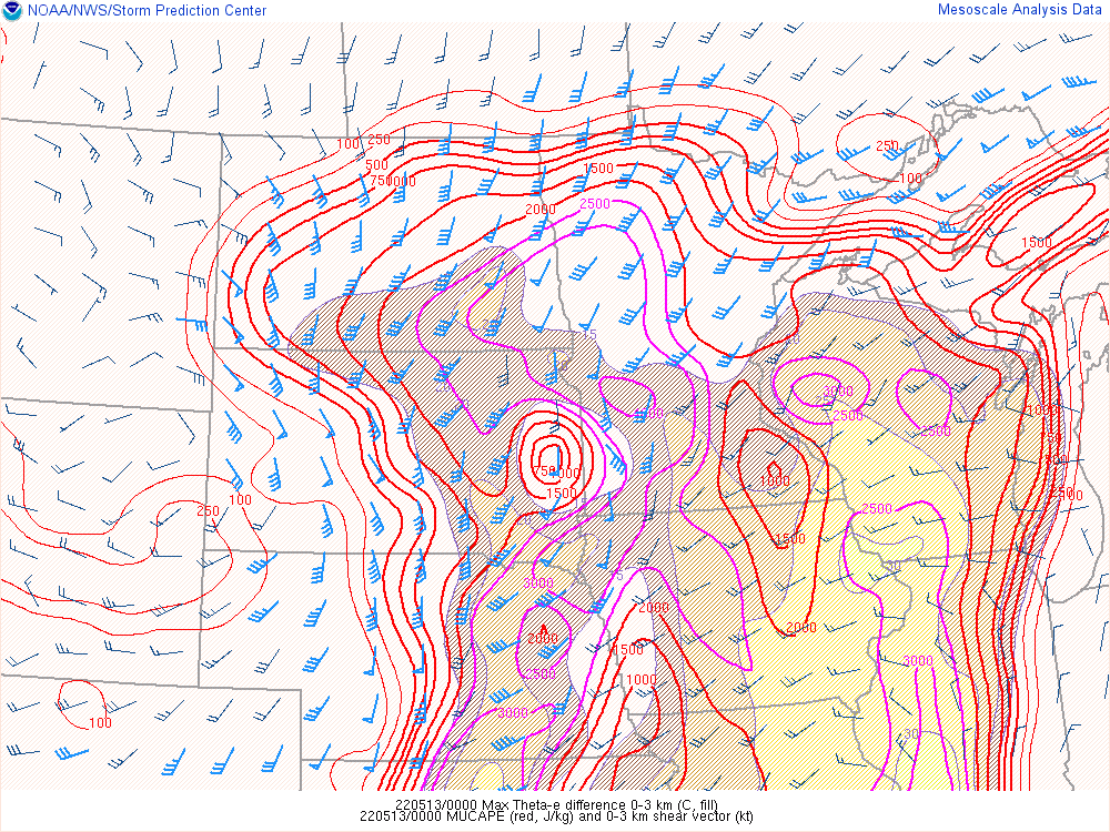
| 18Z Max 0-3KM Theta-E Diff, MUCAPE, Shear | 21Z Max 0-3KM Theta-E Diff, MUCAPE, Shear | 00Z Max 0-3KM Theta-E Diff, MUCAPE, Shear | 03Z Max 0-3KM Theta-E Diff, MUCAPE, Shear |
Additional Information
The Forecast
 |
 |
 |
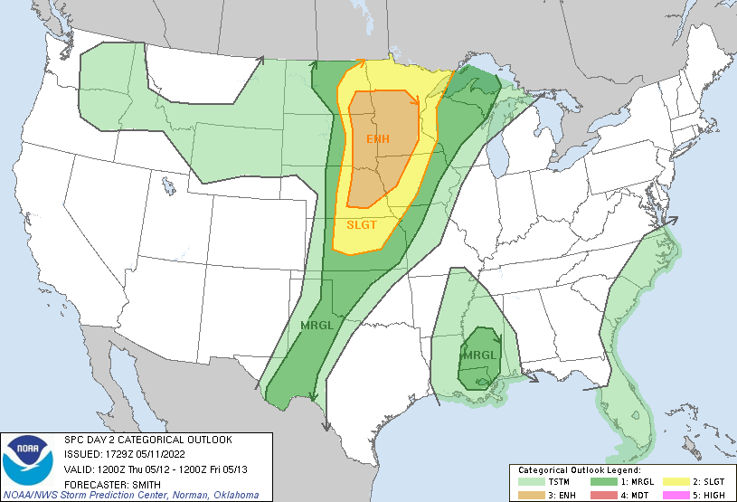 |
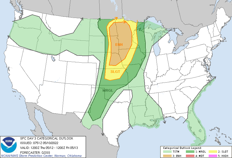
| SPC Day 5 Categorical Outlook | SPC Day 4 Categorical Outlook | SPC Day 3 Categorical Outlook | SPC Day 2 Categorical Outlook |
 |
 |
 |
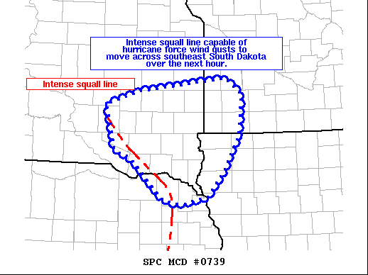 |
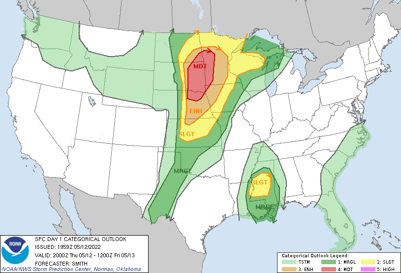
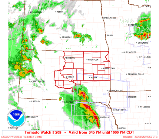
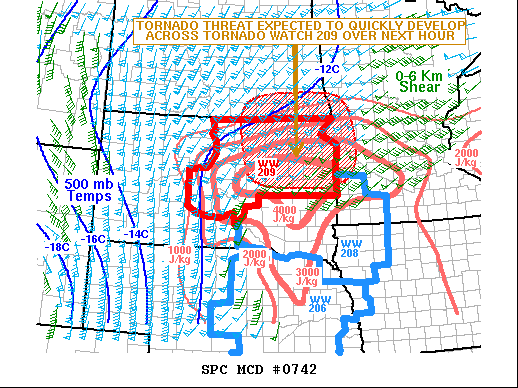
| SPC Day 1 Categorical Outlook | PDS Severe Thunderstorm Watch | Tornado Watch | Mesoscale Discussion |
 |
 |
||
| Mesoscale Discussion | Mesoscale Discussion |
Historical Perspective
Other Composite Index
 |
 |
 |
 |
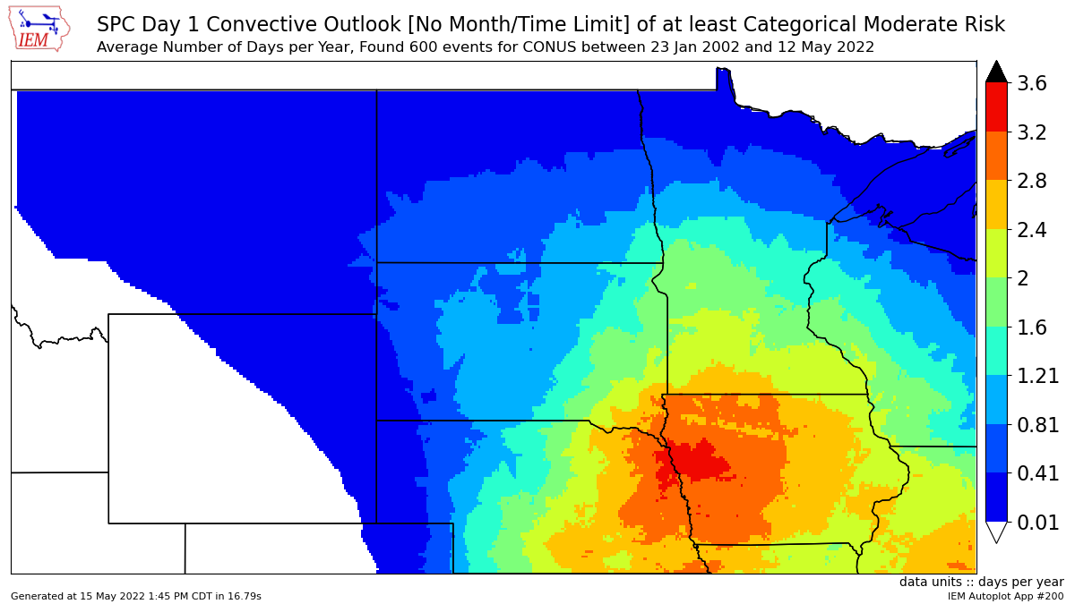
| Since 2004, only one other severe thunderstorm event *nationwide* has produced more measured/reported significant (75+ mph) wind gusts than the one on May 12th, 2022, | Derechos are fairly rare for any given location, so you may not have heard of the term before. Find more detailed information here. | Moderate risks are only issued about 1 to 2 times on average each year. | A "PDS" severe thunderstorm watch was issued for portions of the area. This is the first watch in the Sioux Falls forecast area since 2015, and first "PDS" watch in Sioux Falls Since 2008. |
 |
|||
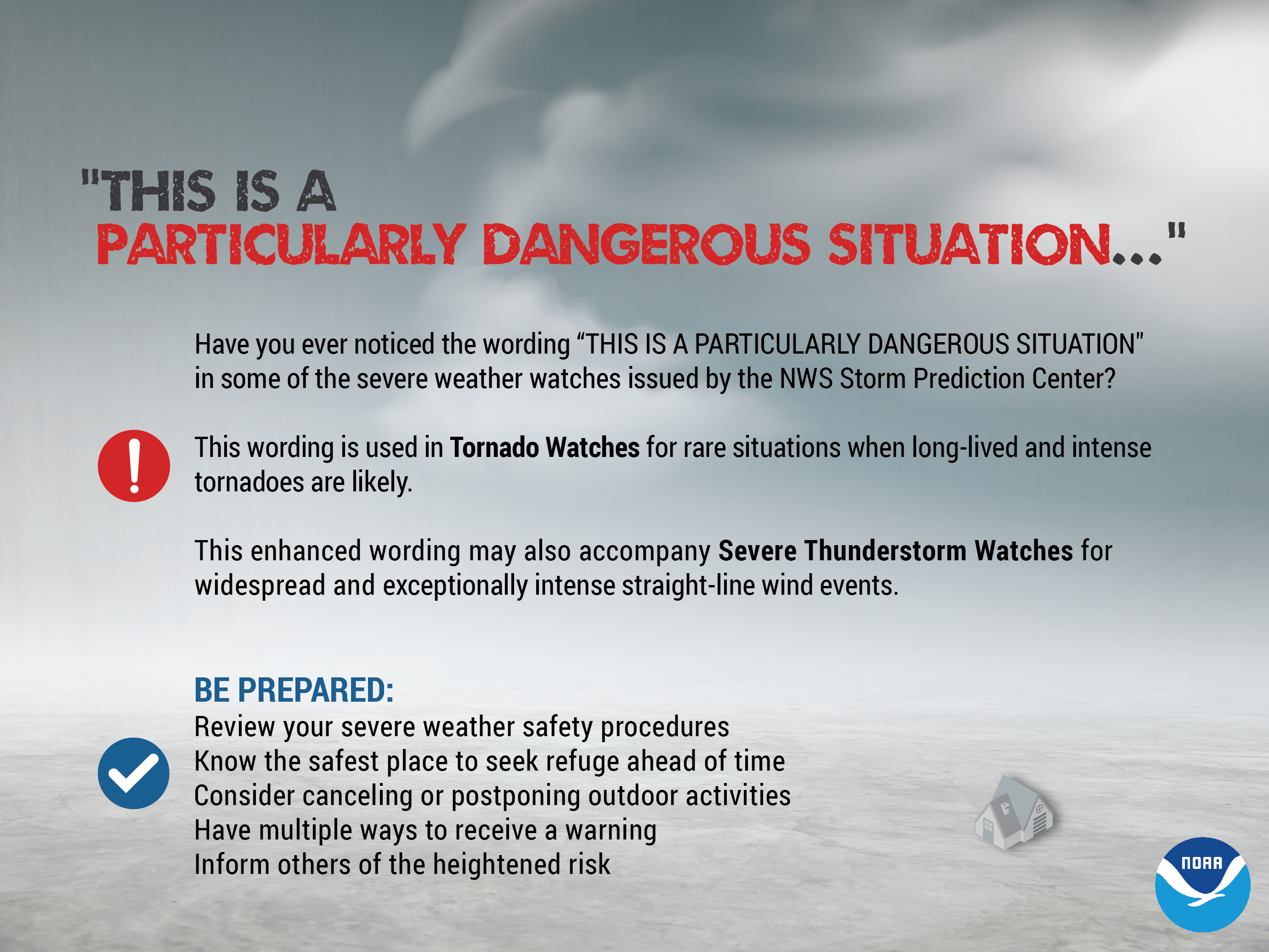
| What does a "Particularily Dangerous Situation" watch mean? Here's a closer look |
Summaries from other NWS Offices
 |
Media use of NWS Web News Stories is encouraged! Please acknowledge the NWS as the source of any news information accessed from this site. |
|


 Weather Story
 Weather Map
 Local Radar
 Follow us on YouTube