Overview
|
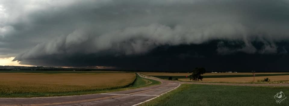
Multiple rounds of severe weather moved across portions of southeastern SD, northwestern IA, and southwestern MN during the afternoon/evening hours on Saturday, Aug. 28, 2021. Extremely large hail, damaging winds, tornadoes, and flooding were reported. The combination of torrential rainfall and numerous rounds of storms triggered both flash flooding and river flooding for portions of the area, despite the drought conditions present at the time of the event. |
(Credit: Brett Davelaar) |
Tornadoes:
|
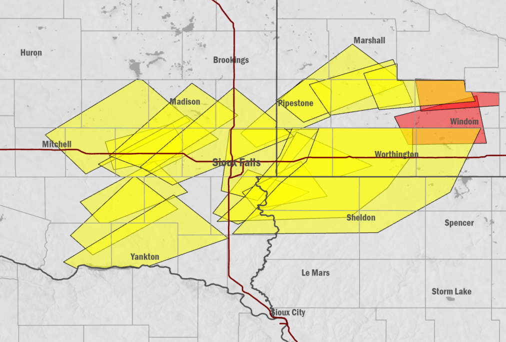
Tornado - Lennox, SD
Track Map 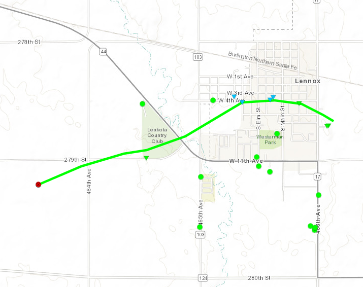 
|
||||||||||||||||
|
Tornado - Lincoln County #2
Track Map 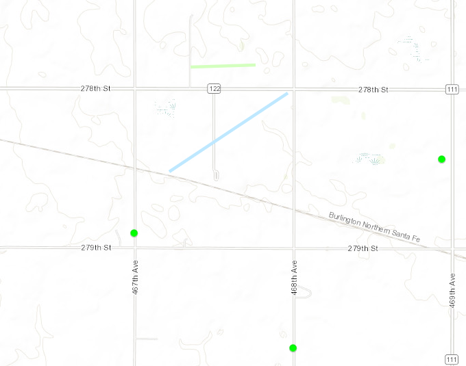
Downloadable KMZ File |
||||||||||||||||
|
Tornado - Lincoln County #3
Track Map 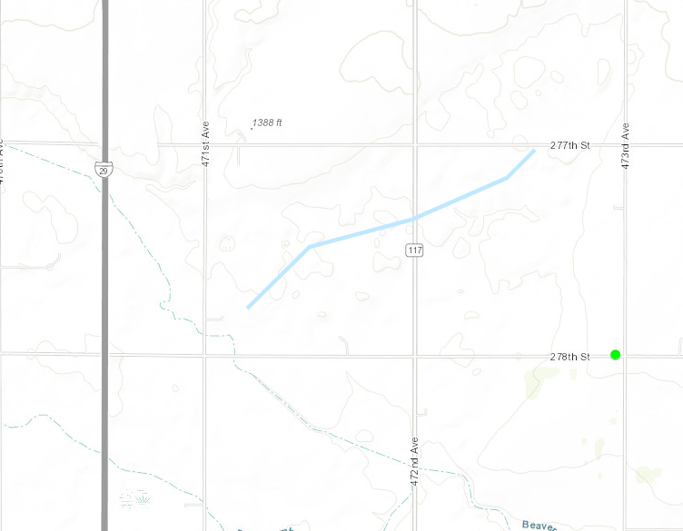
Downloadable KMZ File |
||||||||||||||||
|
Tornado - Lincoln County #4
Track Map 
Downloadable KMZ File |
||||||||||||||||
|
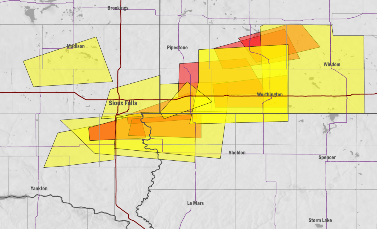
Tornado - Murray County Landfill
Track Map 
Downloadable KMZ File |
||||||||||||||||
|
Tornado - Murray County #2
Track Map 
Downloadable KMZ File |
||||||||||||||||
|
Tornado - Dovray, MN
Track Map 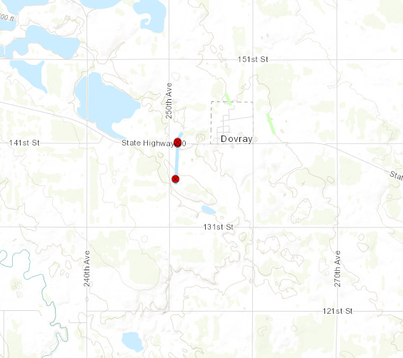
Downloadable KMZ File |
||||||||||||||||
|
Tornado - Murray County #4
Track Map 
Downloadable KMZ File |
||||||||||||||||
|
Tornado - Cottonwood County #1
Track Map 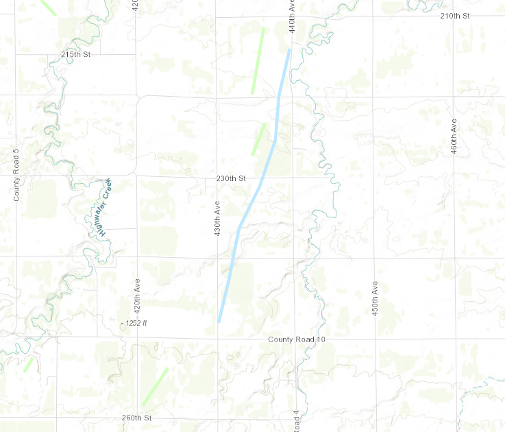
Downloadable KMZ File |
||||||||||||||||
|
Tornado - LOCATION
Track Map
Downloadable KMZ File |
||||||||||||||||
The Enhanced Fujita (EF) Scale classifies tornadoes into the following categories:
| EF0 Weak 65-85 mph |
EF1 Moderate 86-110 mph |
EF2 Significant 111-135 mph |
EF3 Severe 136-165 mph |
EF4 Extreme 166-200 mph |
EF5 Catastrophic 200+ mph |
 |
|||||
Wind & Hail:
Wind
 |
 |
 |
 |
|
Lake Wilson, MN (Credit: Bruce) |
SW of Lennox, SD (Credit: NWS Survey) |
NE of Worthing, SD (Credit: NWS Survey) |
West of Worthing, SD (Credit: NWS Survey) |
 |
 |
 |
 |
|
Hills, MN (Credit: Ben Shappard) |
Lenox, SD (Credit: NWS Survey) |
South of Lennox, SD (Credit: NWS Survey) |
Chandler, MN (Credit: Justin Hicks) |
Hail
 |
 |
 |
 |
|
Lake Wilson, MN (Credit: Brent Dagel) |
Larchwood, IA (Credit: Sue) |
Larchwood, IA (Credit: Matt Bouwman) |
Canton, SD (Credit: Emily Souvignier) |
 |
 |
 |
 |
|
Salem, SD (Credit: Alex Resel) |
Larchwood, IA (Credit: Amber Hess) |
Hills, MN (Credit: Meghan Zylstra) |
Worthing, SD (Jayla Lentini) |
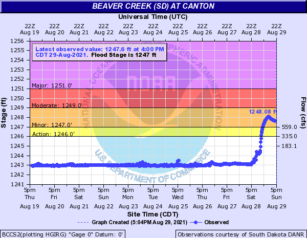
Flooding
Hydrographs
 |
 |
 |
|
| Big Sioux River at Western Ave | Beaver Creek at Canton | Flash Flood Warnings Issued |
0950 PM     FLASH FLOOD      5 WSW ROWENA            43.50N 96.65W
08/28/2021                   MINNEHAHA          SD   PUBLIC

            SEVERAL INCHES TO AROUND A FOOT OF WATER IN
            BACKYARD VIA SOCIAL MEDIA PICTURE.

0951 PM     FLASH FLOOD      1 ENE SIOUX FALLS       43.55N 96.71W
08/28/2021                   MINNEHAHA          SD   PUBLIC

            WATER OVER THE ROAD NEAR 6TH AND CLIFF.
            ESTIMATED ABOUT A FOOT DEEP VIA SOCIAL MEDIA
            PICTURE.

0954 PM     FLASH FLOOD      5 WSW SIOUX FALLS       43.52N 96.82W
08/28/2021                   MINNEHAHA          SD   PUBLIC

            REPORT FROM MPING: RIVER/CREEK OVERFLOWING;
            CROPLAND/YARD/BASEMENT FLOODING.

0957 PM     FLASH FLOOD      5 W SIOUX FALLS         43.53N 96.84W
08/28/2021                   MINNEHAHA          SD   PUBLIC

            REPORT FROM MPING: RIVER/CREEK OVERFLOWING;
            CROPLAND/YARD/BASEMENT FLOODING.

1013 PM     FLASH FLOOD      5 WSW SIOUX FALLS       43.52N 96.82W
08/28/2021                   MINNEHAHA          SD   PUBLIC

            REPORT FROM MPING: RIVER/CREEK OVERFLOWING;
            CROPLAND/YARD/BASEMENT FLOODING.

0902 PM     FLASH FLOOD      TEA                     43.45N 96.83W
08/28/2021                   LINCOLN            SD   PUBLIC

            REPORT FROM MPING: STREET/ROAD FLOODING;
            STREET/ROAD CLOSED; VEHICLES STRANDED.

1014 PM     FLASH FLOOD      TEA                     43.45N 96.83W
08/28/2021                   LINCOLN            SD   PUBLIC

            REPORT FROM MPING: STREET/ROAD FLOODING;
            STREET/ROAD CLOSED; VEHICLES STRANDED.

0955 PM     FLASH FLOOD      PIPESTONE               43.99N 96.32W
08/28/2021                   PIPESTONE          MN   PUBLIC

            DELAYED REPORT FROM SOCIAL MEDIA. REPORT
            STATES THEIR GARAGE IS FLOODED, AND THE
            STREET IN FRONT OF THE HOUSE HAD WATER OVER
            THE CURB.

1100 PM     FLASH FLOOD      3 N AVOCA               43.99N 95.64W
08/28/2021                   MURRAY             MN   LAW ENFORCEMENT

            WATER OVER THE ROAD NEAR COUNTY ROAD 30 AND
            38.
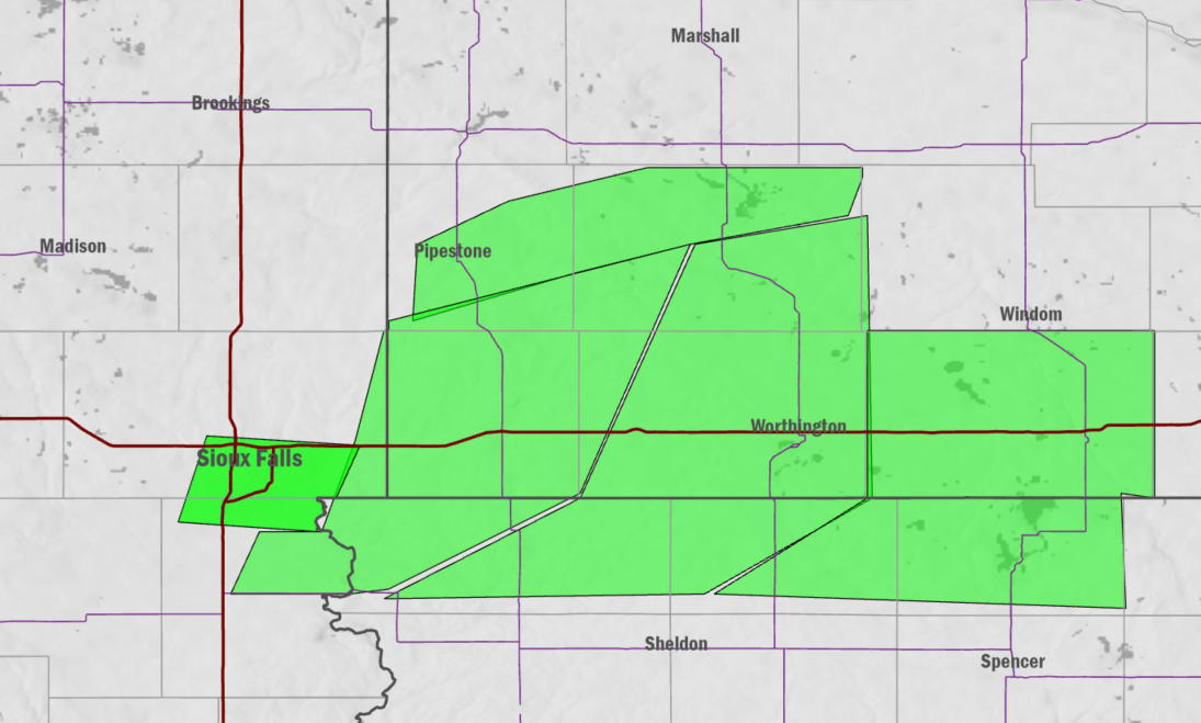
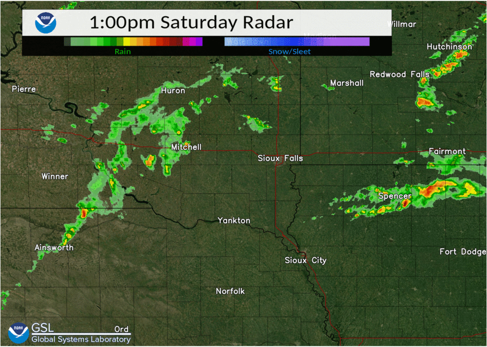
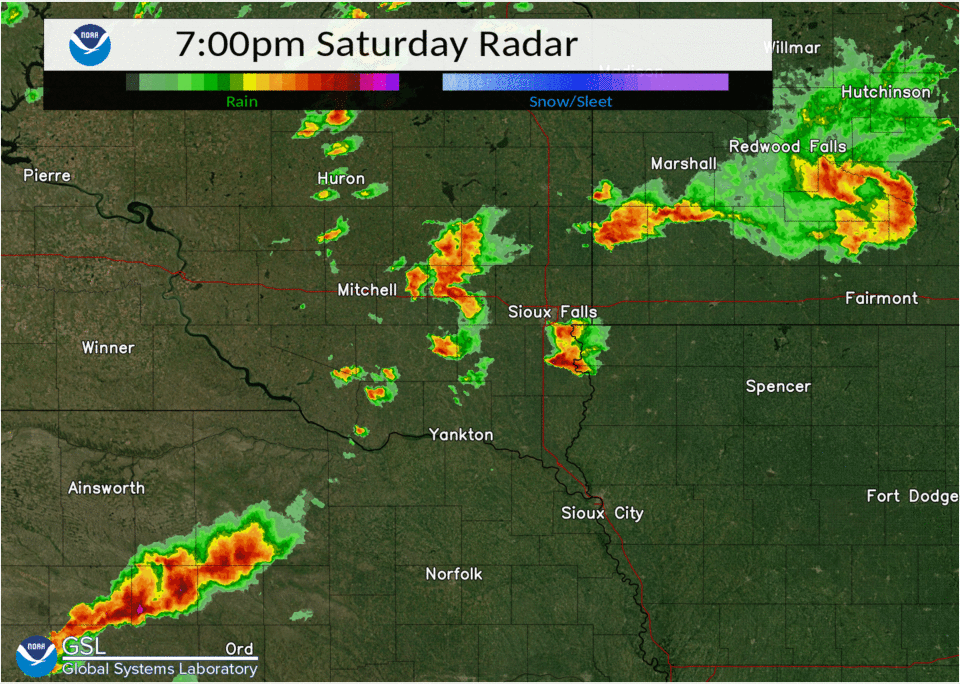
Radar/Warnings
 |
 |
 |
 |
| Radar thru 7 pm | Radar after 7 pm | Warnings thru 5:45 pm | Warnings after 5:45 pm |
Storm Reports
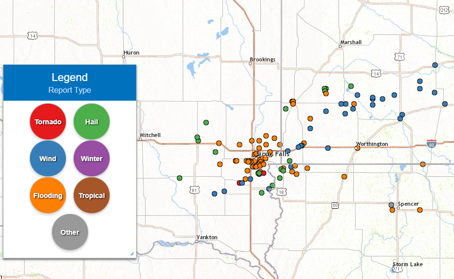 |
| Storm Reports from Aug 28th, 2021 |
0422 PM     TORNADO          1 WSW LENNOX            43.35N 96.92W
08/28/2021                   LINCOLN            SD   NWS STORM SURVEY

            NWS STORM SURVEY FOUND AN EF1 TORNADO BEGAN
            JUST WEST OF TOWN OF LENNOX AND LIFTED JUST
            EAST OF TOWN. PATH LENGTH OF 1.89 MILES AND
            PATH WIDTH OF 400 YARDS. NO INJURIES OR
            FATALITIES REPORTED.
0445 PM     FUNNEL CLOUD     2 E HARRISBURG          43.43N 96.65W
08/28/2021                   LINCOLN            SD   TRAINED SPOTTER

            ROTATION NOTICED IN CLOUDS OVERHEAD, AND
            SURFACE WINDS SEEMED TO BE BLOWING UPWARD.

0415 PM     HAIL             HURLEY                  43.28N 97.09W
08/28/2021  E1.00 INCH       TURNER             SD   EMERGENCY MNGR

            QUARTER SIZED HAIL.

0658 PM     HAIL             SALEM                   43.72N 97.39W
08/28/2021  E1.75 INCH       MCCOOK             SD   NWS EMPLOYEE


0720 PM     HAIL             3 S SALEM               43.69N 97.38W
08/28/2021  M1.75 INCH       MCCOOK             SD   PUBLIC

            REPORT FROM SOCIAL MEDIA, HALF DOLLAR TO
            GOLF BALL SIZE HAIL.

0750 PM     HAIL             5 E CANISTOTA           43.60N 97.19W
08/28/2021  E1.50 INCH       MCCOOK             SD   PUBLIC

            REPORT VIA SOCIAL MEDIA FROM LAKE
            VERMILLION.

0652 PM     HAIL             5 WSW CANTON            43.27N 96.67W
08/28/2021  E1.25 INCH       LINCOLN            SD   PUBLIC

            PICTURE VIA SOCIAL MEDIA.

0655 PM     HAIL             1 W HARRISBURG          43.43N 96.71W
08/28/2021  M1.00 INCH       LINCOLN            SD   PUBLIC

            REPORT FROM MPING: QUARTER (1.00 IN.).

0655 PM     HAIL             HARRISBURG              43.43N 96.70W
08/28/2021  M1.00 INCH       LINCOLN            SD   PUBLIC

            REPORT FROM MPING: QUARTER (1.00 IN.).

0655 PM     HAIL             1 W HARRISBURG          43.43N 96.71W
08/28/2021  U1.00 INCH       LINCOLN            SD   PUBLIC

            REPORT FROM MPING: QUARTER (1.00 IN.).

0655 PM     HAIL             HARRISBURG              43.43N 96.70W
08/28/2021  U1.00 INCH       LINCOLN            SD   PUBLIC

            REPORT FROM MPING: QUARTER (1.00 IN.).

0716 PM     HAIL             2 NE CANTON             43.33N 96.55W
08/28/2021  M1.00 INCH       LINCOLN            SD   TRAINED SPOTTER

            A FEW QUARTERS, MOSTLY NICKEL.

0632 PM     HAIL             5 SE CLAYTON            43.39N 97.59W
08/28/2021  E0.70 INCH       HUTCHINSON         SD   TRAINED SPOTTER


0538 PM     HAIL             HILLS                   43.53N 96.36W
08/28/2021  M1.00 INCH       ROCK               MN   CO-OP OBSERVER

            DELAYED REPORT. MOST OF THE HAIL WAS DIMES
            OR SMALLER, BUT THERE WERE A FEW
            QUARTER-SIZED HAIL STONES.

0808 PM     HAIL             HILLS                   43.53N 96.36W
08/28/2021  E1.75 INCH       ROCK               MN   PUBLIC

            REPORT VIA SOCIAL MEDIA.

0831 PM     HAIL             1 SSW LUVERNE           43.65N 96.22W
08/28/2021  U0.50 INCH       ROCK               MN   PUBLIC

            REPORT FROM MPING: HALF-INCH (0.50 IN.).

0620 PM     HAIL             3 NNW IHLEN             43.95N 96.40W
08/28/2021  M1.00 INCH       PIPESTONE          MN   TRAINED SPOTTER

            DELAYED REPORT.

0736 PM     HAIL             2 SSW CURRENT LAKE      44.11N 95.97W
08/28/2021  M3.50 INCH       MURRAY             MN   PUBLIC

            PICTURE VIA SOCIAL MEDIA.

0740 PM     HAIL             3 SSW CURRENT LAKE      44.09N 95.96W
08/28/2021  E2.00 INCH       MURRAY             MN   TRAINED SPOTTER

            DELAYED REPORT. MEASURED HAIL AT 2.25 INCHES
            IN DIAMETER.

0741 PM     HAIL             2 SSW CURRENT LAKE      44.11N 95.95W
08/28/2021  M4.00 INCH       MURRAY             MN   PUBLIC

            DELAYED REPORT. SOCIAL MEDIA REPORTS LARGE
            HAIL MEASURED AT 3.75 INCHES.

0821 PM     HAIL             4 N CURRIE              44.13N 95.67W
08/28/2021  E1.75 INCH       MURRAY             MN   TRAINED SPOTTER

            LOTS OF GOLF BALL SIZED HAIL AND HEAVY
            RAINFALL 3.40 INCHES SO FAR.

0735 PM     HAIL             5 SSW LARCHWOOD         43.39N 96.47W
08/28/2021  M1.00 INCH       LYON               IA   TRAINED SPOTTER

            MOSTLY PEA-SIZED HAIL FOR ABOUT 5 MINUTES,
            LARGEST HAIL STONES WERE QUARTER SIZED.

0748 PM     HAIL             1 WNW LARCHWOOD         43.46N 96.45W
08/28/2021  M2.50 INCH       LYON               IA   TRAINED SPOTTER


0748 PM     HAIL             LARCHWOOD               43.45N 96.43W
08/28/2021  E4.00 INCH       LYON               IA   PUBLIC

            MULTIPLE PICTURES FROM AROUND LARCHWOOD VIA
            SOCIAL MEDIA OF HAIL RANGING FROM TENNIS
            BALL SIZE TO AS LARGE AS 4 INCHES IN
            DIAMETER.

0753 PM     HAIL             LESTER                  43.44N 96.33W
08/28/2021  E1.00 INCH       LYON               IA   PUBLIC

            VIA SOCIAL MEDIA.
0438 PM     TSTM WND DMG     2 SSE SIOUX FALLS       43.51N 96.72W
08/28/2021                   MINNEHAHA          SD   PUBLIC

            DELAYED REPORT FROM SOCIAL MEDIA. LARGE TREE
            KNOCKED OVER AND ONTO THE FENCE AT SPENCER
            DOG PARK.

0430 PM     TSTM WND DMG     4 NNW WORTHING          43.38N 96.80W
08/28/2021                   LINCOLN            SD   PUBLIC

            REPORT VIA SOCIAL MEDIA OF 2 SEMI TRUCKS
            FLIPPED OVER A LITTLE SOUTH OF I-29 EXIT 68.

0440 PM     TSTM WND DMG     CANTON                  43.30N 96.59W
08/28/2021                   LINCOLN            SD   PUBLIC

            SOCIAL MEDIA PICTURE OF LARGE TREE DOWN.

0440 PM     TSTM WND DMG     HARRISBURG              43.43N 96.70W
08/28/2021                   LINCOLN            SD   PUBLIC

            REPORT VIA SOCIAL MEDIA OF TREE DAMAGE IN
            HARRISBURG.

0540 PM     TSTM WND DMG     HILLS                   43.53N 96.36W
08/28/2021                   ROCK               MN   CO-OP OBSERVER

            DELAYED REPORT. TREES REPORTED DOWN,
            DIAMETER OF THE TRUNKS WAS 2-3 FEET. A POWER
            LINE WAS KNOCKED DOWN AS WELL, RESULTING IN
            POWER OUTAGE OF ABOUT 3 HOURS.

0620 PM     TSTM WND DMG     3 NNW IHLEN             43.95N 96.40W
08/28/2021                   PIPESTONE          MN   TRAINED SPOTTER

            DELAYED REPORT. LARGE TREE BRANCHES DOWN
            FROM A COTTONWOOD TREE, BRANCHES WERE AROUND
            5 INCHES IN DIAMETER.

0523 PM     TSTM WND DMG     ADRIAN                  43.63N 95.93W
08/28/2021                   NOBLES             MN   EMERGENCY MNGR

            STRONG WINDS KNOCKED TREES DOWN IN THE
            SOUTHERN PART OF ADRIAN.

0521 PM     TSTM WND DMG     CHANDLER                43.93N 95.95W
08/28/2021                   MURRAY             MN   EMERGENCY MNGR

            4 TO 6 INCH DIAMETER TREE BRANCHES BROKEN
            DOWN BY WIND GUSTS.

0530 PM     TSTM WND DMG     2 E IONA                43.91N 95.74W
08/28/2021                   MURRAY             MN   EMERGENCY MNGR

            TREES SNAPPED BY WINDS.

0536 PM     TSTM WND DMG     AVOCA                   43.95N 95.65W
08/28/2021                   MURRAY             MN   EMERGENCY MNGR

            MACHINE SHED DAMAGED.

0545 PM     TSTM WND DMG     AVOCA                   43.95N 95.65W
08/28/2021                   MURRAY             MN   PUBLIC

            REPORT VIA SOCIAL MEDIA OF HEAVY TREE DAMAGE
            IN AVOCA.

0558 PM     TSTM WND DMG     1 E SLAYTON             43.99N 95.73W
08/28/2021                   MURRAY             MN   PUBLIC

            REPORT VIA SOCIAL MEDIA OF TREE DAMAGE EAST
            OF SLAYTON.

0546 PM     TSTM WND DMG     1 S WESTBROOK           44.03N 95.43W
08/28/2021                   COTTONWOOD         MN   EMERGENCY MNGR

            GRAIN BIN DAMAGED 1/2 MILE SOUTH OF
            WESTBROOK. DAMAGE ALSO TO OLD BARN 1 SOUTH
            OF WESTBROOK.

0550 PM     TSTM WND DMG     WESTBROOK               44.04N 95.43W
08/28/2021                   COTTONWOOD         MN   EMERGENCY MNGR

            DAMAGE TO WESTBROOK LUMBER BUILDING. WIND
            GUSTS ESTIMATED AT 70 MPH.

0554 PM     TSTM WND DMG     1 S STORDEN             44.03N 95.32W
08/28/2021                   COTTONWOOD         MN   EMERGENCY MNGR

            GRAIN BIN DAMAGE 1/2 MILE SOUTH OF STORDEN.

0603 PM     TSTM WND DMG     JEFFERS                 44.06N 95.19W
08/28/2021                   COTTONWOOD         MN   PUBLIC

            LARGE TREE, ROUGHLY ONE TO TWO FEET IN
            DIAMETER, SNAPPED IN HALF. PICTURE VIA
            SOCIAL MEDIA.

0606 PM     TSTM WND DMG     WINDOM                  43.87N 95.12W
08/28/2021                   COTTONWOOD         MN   PUBLIC

            REPORT FROM MPING: TREES UPROOTED OR
            SNAPPED; ROOF BLOWN OFF.

0606 PM     TSTM WND DMG     WINDOM                  43.87N 95.12W
08/28/2021                   COTTONWOOD         MN   PUBLIC

            REPORT FROM MPING: TREES UPROOTED OR
            SNAPPED; ROOF BLOWN OFF.

0616 PM     TSTM WND DMG     4 S WESTBROOK           43.98N 95.43W
08/28/2021                   COTTONWOOD         MN   EMERGENCY MNGR

            NUMEROUS TREES DOWN AND LAYING ACROSS ROAD.

0812 PM     TSTM WND DMG     3 NNW LESTER            43.48N 96.34W
08/28/2021                   LYON               IA   PUBLIC

            REPORT FROM MPING: 3-INCH TREE LIMBS BROKEN;
            POWER POLES BROKEN.

0407 PM     TSTM WND GST     6 WSW HURLEY            43.26N 97.20W
08/28/2021  E70 MPH          TURNER             SD   TRAINED SPOTTER

            CORRECTS PREVIOUS TSTM WND GST REPORT FROM 6
            WSW HURLEY. WINDS AROUND 70 MPH MAKING THE
            BACK OF HIS PICKUP TRUCK DANCE AROUND. HEAVY
            RAIN AND PEA SIZED HAIL TOO.

0419 PM     TSTM WND GST     HURLEY                  43.28N 97.09W
08/28/2021  E70 MPH          TURNER             SD   EMERGENCY MNGR

            WIND GUSTS 60-70 MPH.

0435 PM     TSTM WND GST     3 NNW SIOUX FALLS       43.58N 96.75W
08/28/2021  M55 MPH          MINNEHAHA          SD   ASOS

            DELAYED REPORT. ASOS STATION KFSD SIOUX
            FALLS AIRPORT.

0424 PM     TSTM WND GST     LENNOX                  43.35N 96.89W
08/28/2021  M72 MPH          LINCOLN            SD   MESONET

            DELAYED REPORT. PERSONAL WEATHER STATION
            REPORTED GUST OF 72 MPH.

0440 PM     TSTM WND GST     1 SSW HARRISBURG        43.42N 96.70W
08/28/2021  M61 MPH          LINCOLN            SD   MESONET

            CORRECTS PREVIOUS TSTM WND GST REPORT FROM 1
            SSW HARRISBURG FOR INCORRECT TIME. DELAYED
            REPORT. PERSONAL WEATHER STATION REPORTED
            GUST OF 61 MPH.

0445 PM     TSTM WND GST     2 E HARRISBURG          43.43N 96.65W
08/28/2021  E70 MPH          LINCOLN            SD   TRAINED SPOTTER

            BRANCHES ON COTTONWOOD TREE BLOWN UPWARD AND
            OFF, LANDING ON ROOF OF HOUSE.

0457 PM     TSTM WND GST     1 WSW BEAVER CREEK      43.61N 96.38W
08/28/2021  M68 MPH          ROCK               MN   MESONET

            DELAYED REPORT FROM BEAVER CREEK I-90 MP 4,
            MN. MN006.

0500 PM     TSTM WND GST     3 WSW LUVERNE           43.64N 96.26W
08/28/2021  M61 MPH          ROCK               MN   MESONET

            DELAYED REPORT FROM MESONET STATION FW5856
            LUVERNE.

0503 PM     TSTM WND GST     1 WSW LUVERNE           43.65N 96.23W
08/28/2021  M61 MPH          ROCK               MN   MESONET

            DELAYED REPORT FROM PERSONAL WEATHER STATION
            JUST WEST OF LUVERNE, MN.

0511 PM     TSTM WND GST     3 ENE HARDWICK          43.79N 96.13W
08/28/2021  M68 MPH          ROCK               MN   MESONET

            RELAYED REPORT FROM PERSONAL WEATHER STATION
            REPORTED GUST OF 68 MPH.

0545 PM     TSTM WND GST     WORTHINGTON             43.63N 95.60W
08/28/2021  E55 MPH          NOBLES             MN   EMERGENCY MNGR

            WALL CLOUD PUSHED ACROSS TOWN, SWITCHING
            WINDS FROM NEARLY CALM TO GUSTY AT 44 TO 55
            MPH.

0544 PM     TSTM WND GST     1 W SLAYTON             43.99N 95.78W
08/28/2021  M60 MPH          MURRAY             MN   AWOS


0839 PM     TSTM WND GST     3 W DOVRAY              44.06N 95.60W
08/28/2021  M59 MPH          MURRAY             MN   MESONET

            DELAYED REPORT FROM MESONET STATION MN038
            DOVRAY MN-30 MILE POST 49.

0606 PM     TSTM WND GST     2 NNE WINDOM            43.90N 95.10W
08/28/2021  M66 MPH          COTTONWOOD         MN   AWOS

            DELAYED REPORT. AWOS STATION KMWM WINDOM
            MUNICIPAL AIRPORT REPORTED GUST OF 66 MPH.

1042 PM     TSTM WND GST     4 WNW SPENCER           43.17N 95.22W
08/28/2021  M75 MPH          CLAY               IA   ASOS

            CORRECTS PREVIOUS NON-TSTM WND GST REPORT
            FROM 4 WNW SPENCER. DELAYED REPORT FROM ASOS
            STATION KSPW SPENCER MUNICIPAL AIRPORT.
Rain Reports
 |
| Storm Reports from Aug 28th, 2021 |
Location                       Amount    Time/Date       Provider

Tracy 7.8 SSW                  6.70 in   0930 AM 08/29   COCORAHS
Harrisburg 0.7 NNE             5.40 in   0726 AM 08/29   COCORAHS
Currie 0.3 NNE                 5.20 in   0945 AM 08/29   COCORAHS
Larchwood 1.2 NNE              5.17 in   0800 AM 08/29   COCORAHS
Hills 0.2 NW                   4.94 in   0800 AM 08/29   COCORAHS
Sioux Falls 3.1 SE             4.70 in   0700 AM 08/29   COCORAHS
Lester 0.2 E                   4.66 in   0700 AM 08/29   COCORAHS
Sioux Falls 4.2 S              4.52 in   0700 AM 08/29   COCORAHS
Sioux Falls 2.7 ESE            4.49 in   0700 AM 08/29   COCORAHS
Sioux Falls 4.0 SE             4.46 in   0700 AM 08/29   COCORAHS
Sioux Falls 5.0 SE ARP         4.34 in   0700 AM 08/29   COCORAHS
Sioux Falls 3.6 SSE            4.30 in   0700 AM 08/29   COCORAHS
Rock Rapids 7.7 WNW            4.23 in   0700 AM 08/29   COCORAHS
Sioux Falls 4.5 S              4.20 in   0700 AM 08/29   COCORAHS
Sioux Falls 5.2 E              4.17 in   0700 AM 08/29   COCORAHS
Lennox 3.3 NE                  4.16 in   0700 AM 08/29   COCORAHS
Tea 1.1 NNW                    3.70 in   0700 AM 08/29   COCORAHS
Sioux Falls 3.7 WSW            3.66 in   0900 AM 08/29   COCORAHS
Sioux Falls 2.6 ESE            3.60 in   0630 AM 08/29   COCORAHS
Sioux Falls 4.1 WSW            3.58 in   0700 AM 08/29   COCORAHS
Brandon 0.4 NNE                3.56 in   0700 AM 08/29   COCORAHS
Rock Rapids 5.6 W              3.55 in   0700 AM 08/29   COCORAHS
Garretson 0.5 SW               3.55 in   0700 AM 08/29   COCORAHS
Sioux Falls 3.4 WSW            3.55 in   0700 AM 08/29   COCORAHS
Pipestone                      3.52 in   0800 AM 08/29   COOP
Sioux Falls 4.2 WSW            3.46 in   0700 AM 08/29   COCORAHS
Luverne                        3.39 in   0700 AM 08/29   CWOP
Sioux Falls 4.0 SSE            3.38 in   0700 AM 08/29   COCORAHS
Sioux Falls Airport            3.35 in   0700 AM 08/29   ASOS
Sioux Falls 3.3 E              3.32 in   0700 AM 08/29   COCORAHS
Garretson 7.3 WSW              3.26 in   0705 AM 08/29   COCORAHS
Redstone RAWS                  3.26 in   0700 AM 08/29   RAWS
Garretson 6.9 W                3.24 in   0800 AM 08/29   COCORAHS
Garretson 4.2 SSE              3.16 in   0700 AM 08/29   COCORAHS
Sioux Falls 5.5 N              3.14 in   0700 AM 08/29   COCORAHS
Hartford 2.7 NNE               2.80 in   0700 AM 08/29   COCORAHS
Sioux Falls 1.9 SSW            2.79 in   0915 AM 08/29   COCORAHS
Sibley                         2.76 in   0700 AM 08/29   COOP
Wall Lake                      2.65 in   0700 AM 08/29   UCOOP
Garretson 1.7 WSW              2.57 in   0700 AM 08/29   COCORAHS
Renner 4.1 NW                  2.50 in   0700 AM 08/29   COCORAHS
SD RWIS Montrose               2.41 in   0700 AM 08/29   SDDOT
Rock Rapids 3.0 N              2.26 in   0700 AM 08/29   COCORAHS
2.7 NE Hartford                2.14 in   0700 AM 08/29   UCOOP
Parker 7.2 N                   2.10 in   0700 AM 08/29   COCORAHS
Spencer Airport                2.09 in   0553 PM 08/29   ASOS
3.2 W Spencer                  1.93 in   0545 PM 08/29   HADS
6.0 NW Ihlen                   1.91 in   0530 PM 08/29   HADS
Colton 3.8 S                   1.91 in   0300 PM 08/29   COCORAHS
Montrose                       1.86 in   0700 AM 08/29   COOP
Worthington 1.9 SW             1.77 in   0700 AM 08/29   COCORAHS
Alta 0.3 SE                    1.73 in   0700 AM 08/29   COCORAHS
5 SSE Baltic                   1.67 in   0550 PM 08/29   AWS
Montrose 2.4 E                 1.67 in   0700 AM 08/29   COCORAHS
Estherville                    1.63 in   0251 PM 08/29   CWOP
Dell Rapids 0.9 WNW            1.62 in   0700 AM 08/29   COCORAHS
Worthington 4.0 S              1.46 in   0700 AM 08/29   COCORAHS
Lakefield 2 NE                 1.44 in   0700 AM 08/29   COOP
Okabena 3.2 S                  1.42 in   0700 AM 08/29   COCORAHS
Montrose 3.1 SW                1.42 in   0800 AM 08/29   COCORAHS
0.9 NE Luverne                 1.35 in   0530 PM 08/29   COOP
6 NW Orleans                   1.34 in   0550 PM 08/29   AWS
Montrose 5.8 NW                1.30 in   0700 AM 08/29   COCORAHS
Milford                        1.25 in   0546 PM 08/29   CWOP
Sheldon                        1.23 in   0700 AM 08/29   COOP
Lake Park 3.2 SSE              1.19 in   0700 AM 08/29   COCORAHS
Wahpeton                       1.18 in   0555 PM 08/29   AWS
Marion 4.8 NNW                 1.11 in   0800 AM 08/29   COCORAHS
2.6 NW Windom                  1.07 in   0800 AM 08/29   COOP
Lakefield 7.8 N                1.04 in   0700 AM 08/29   COCORAHS
0.8 SW Linn Grove              1.02 in   0500 PM 08/29   COOP
 |
Media use of NWS Web News Stories is encouraged! Please acknowledge the NWS as the source of any news information accessed from this site. |
|


 Weather Story
 Weather Map
 Local Radar
 Follow us on YouTube