Overview
|
A long stretch of above normal temperatures, even record breaking, came to an abrupt end on March 10th as showers and thunderstorms lifted northward. The first true Spring thunderstorms brought needed rain to the area, along with very small hail. As the morning moved on, colder air caused this precipitation to turn to snow across portions of South Central through northeastern areas of South Dakota. Total snowfall ranged from a dusting to as much as 7 inches of snow. Colder air arriving during the evening led to flash freezing on area roads, leading to challenging driving conditions the morning after the snow ended. |
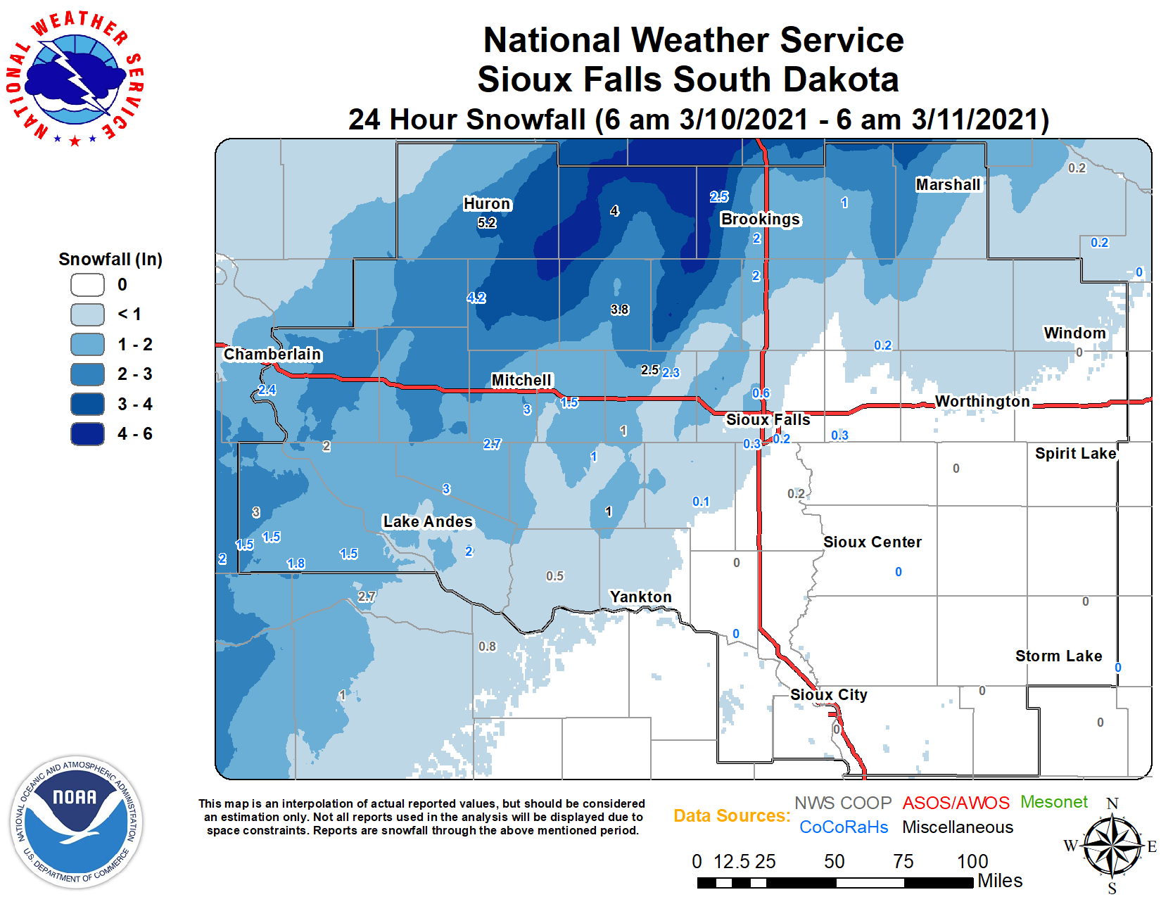 Snowfall Accumulations March 10, 2021 |
Storm Reports
PRELIMINARY LOCAL STORM REPORT...SUMMARY
NATIONAL WEATHER SERVICE SIOUX FALLS SD
1135 AM CST THU MAR 11 2021

..TIME...   ...EVENT...      ...CITY LOCATION...     ...LAT.LON...
..DATE...   ....MAG....      ..COUNTY LOCATION..ST.. ...SOURCE....
            ..REMARKS..

0700 AM     SNOW             4 SW IVANHOE            44.43N 96.31W
03/11/2021  M1.0 INCH        LINCOLN            MN   COCORAHS

            STORM TOTAL SNOW.

0600 AM     SNOW             2 S HURON               44.34N 98.22W
03/11/2021  M5.2 INCH        BEADLE             SD   OFFICIAL NWS OBS

            STORM TOTAL SNOW.

0700 AM     SNOW             BROOKINGS               44.30N 96.79W
03/11/2021  M2.3 INCH        BROOKINGS          SD   COCORAHS

            STORM TOTAL SNOW.

0800 AM     SNOW             6 W BRUCE               44.44N 97.01W
03/11/2021  M2.5 INCH        BROOKINGS          SD   COCORAHS

            STORM TOTAL SNOW.

0950 AM     SNOW             8 NNE CHAMBERLAIN       43.91N 99.26W
03/11/2021  M3.0 INCH        BRULE              SD   COCORAHS

            STORM TOTAL SNOW.

0900 AM     SNOW             13 WNW PLATTE           43.49N 99.06W
03/11/2021  M2.0 INCH        CHARLES MIX        SD   CO-OP OBSERVER

            STORM TOTAL SNOW.

0900 AM     SNOW             LOOMIS                  43.79N 98.11W
03/11/2021  E4.5 INCH        DAVISON            SD   PUBLIC

            STORM TOTAL SNOW. RECEIVED REPORT VIA SOCIAL
            MEDIA.

0959 AM     SNOW             1 SSE MITCHELL          43.72N 98.03W
03/11/2021  M3.1 INCH        DAVISON            SD   COCORAHS

            STORM TOTAL SNOW.

0700 AM     SNOW             5 W ARMOUR              43.33N 98.44W
03/11/2021  M3.0 INCH        DOUGLAS            SD   COCORAHS

            STORM TOTAL SNOW.

0700 AM     SNOW             5 SSW HERRICK           43.04N 99.21W
03/11/2021  M1.8 INCH        GREGORY            SD   COCORAHS

            STORM TOTAL SNOW.

0700 AM     SNOW             1 WNW GREGORY           43.24N 99.43W
03/11/2021  M3.0 INCH        GREGORY            SD   CO-OP OBSERVER

            STORM TOTAL SNOW.

1000 AM     SNOW             4 SSW PICKSTOWN         43.02N 98.56W
03/11/2021  M2.0 INCH        GREGORY            SD   CO-OP OBSERVER

            STORM TOTAL SNOW.

0730 AM     SNOW             DE SMET                 44.38N 97.55W
03/11/2021  M4.0 INCH        KINGSBURY          SD   CO-OP OBSERVER

            STORM TOTAL SNOW.

0920 AM     SNOW             1 SSE MADISON           43.99N 97.09W
03/11/2021  M1.6 INCH        LAKE               SD   CO-OP OBSERVER

            STORM TOTAL SNOW.

1000 PM     SNOW             5 NE SALEM              43.78N 97.32W
03/10/2021  M2.5 INCH        MCCOOK             SD   CO-OP OBSERVER


0700 AM     SNOW             6 NW MONTROSE           43.76N 97.27W
03/11/2021  M2.3 INCH        MCCOOK             SD   COCORAHS

            STORM TOTAL SNOW.

0600 AM     SNOW             HOWARD                  44.01N 97.52W
03/11/2021  M3.8 INCH        MINER              SD   TRAINED SPOTTER

            STORM TOTAL SNOW.

0700 AM     SNOW             10 E NUNDA              44.14N 96.82W
03/11/2021  M2.0 INCH        MOODY              SD   COCORAHS

            STORM TOTAL SNOW.

0954 AM     SNOW             WOONSOCKET              44.05N 98.28W
03/11/2021  M4.2 INCH        SANBORN            SD   PUBLIC

            STORM TOTAL SNOW. REPORT FROM COCORAHS.
 |
Media use of NWS Web News Stories is encouraged! Please acknowledge the NWS as the source of any news information accessed from this site. |
|


 Weather Story
 Weather Map
 Local Radar
 Follow us on YouTube