July 6-7, 2020 Severe Thunderstorm Summary
|
Two waves of strong to severe thunderstorms rolled across portions of southeast South Dakota into extreme northeast Nebraska and northwest Iowa July 6-7, 2020. Large hail up to 3 inches in diameter, damaging wind gusts from 60 to 70 mph, and isolated flash flooding occurred with these storms. The largest hail fell near Alexandria, SD, whereas the greatest impacts from damaging straight line wind were in and around communities near the Missouri River downstream from Chamberlain, SD. In addition, isolated flash flooding occurred across parts of Douglas County, SD. |
 Thunderstorm near Vermillion, SD - Derek Thompson |
Photos
 |
 |
 |
 |
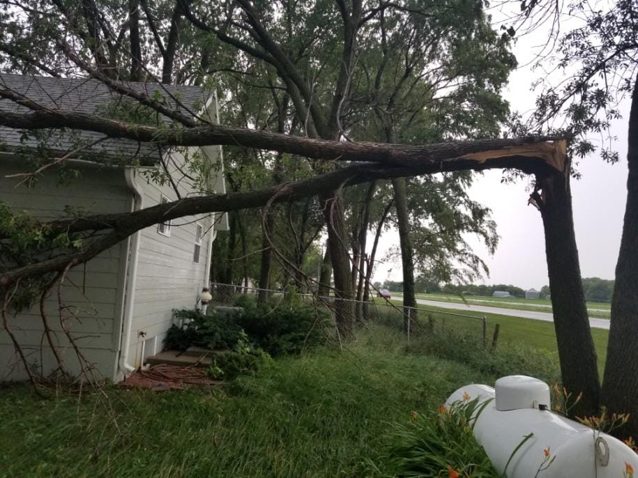
| Snapped Tree near Yankton, SD (Amy Westrum) |
Hail in North Sioux City, SD (Pete Hawkinson) |
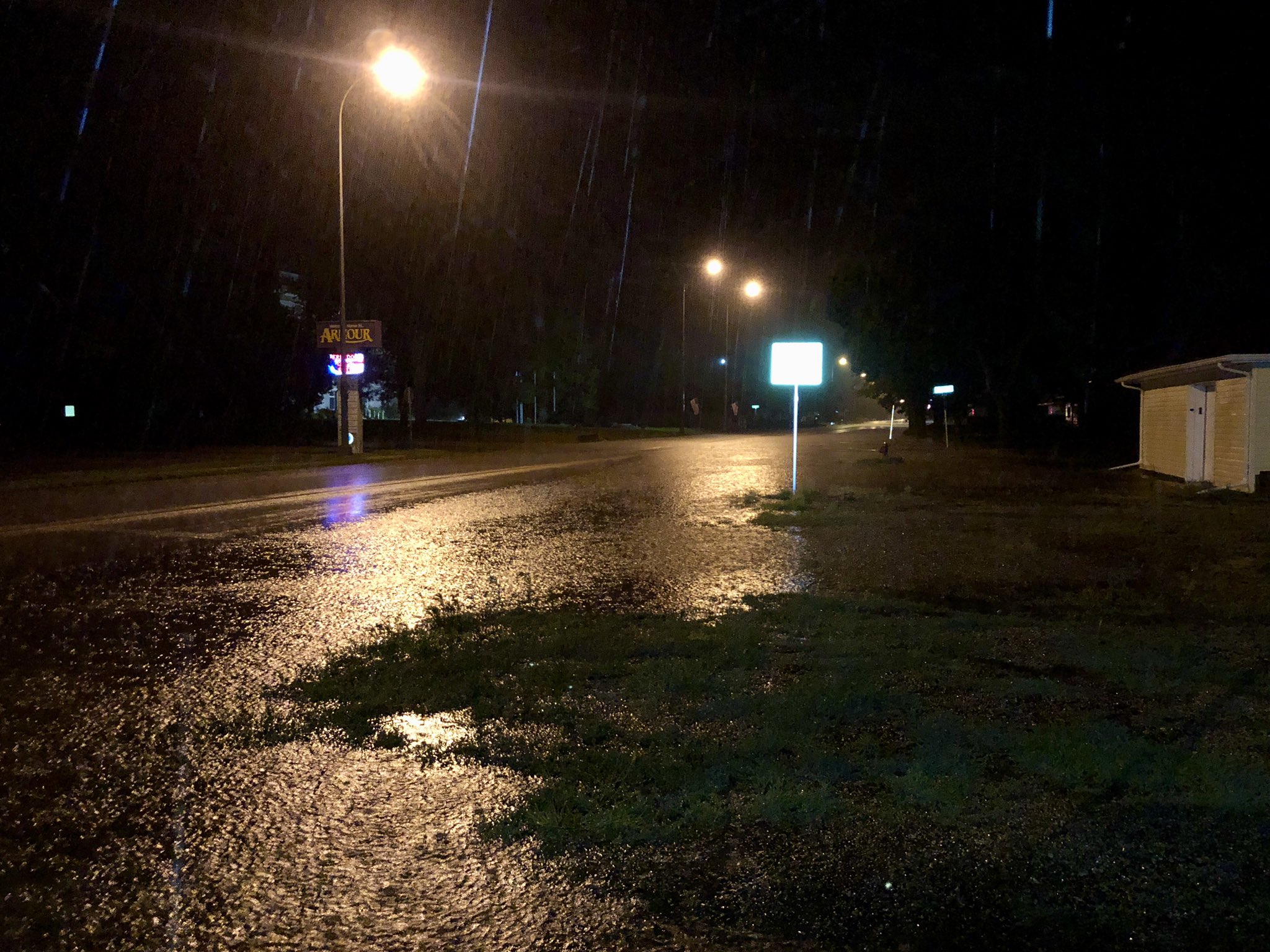
Flash Flooding in Armour, SD (Derek Thompson) |
Rainbow in Sioux City, IA (Scott Larson) |
Radar
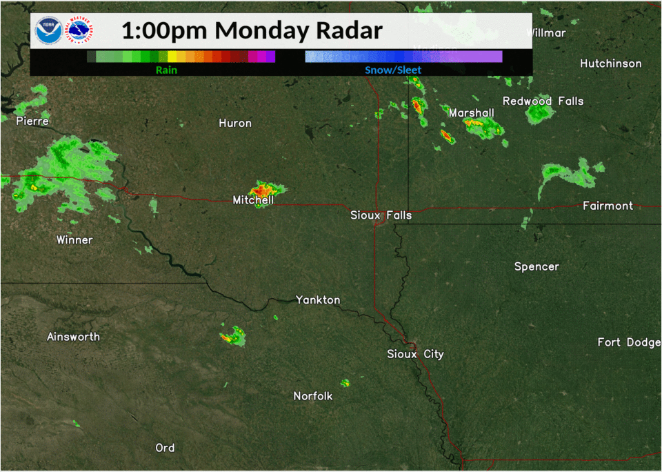 |
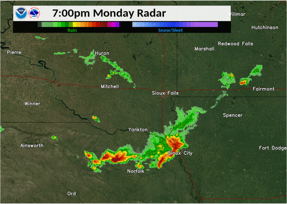 |
 |
| Radar Loop: 1-7 PM July 6 | Radar Loop: 7PM July 6 - 1AM July 7 | Radar Loop: 1-7 AM July 7 |
Storm Reports
PRELIMINARY LOCAL STORM REPORT...SUMMARY
NATIONAL WEATHER SERVICE SIOUX FALLS SD
208 PM CDT TUE JUL 7 2020

..TIME...   ...EVENT...      ...CITY LOCATION...     ...LAT.LON...
..DATE...   ....MAG....      ..COUNTY LOCATION..ST.. ...SOURCE....
            ..REMARKS..

0815 AM     HAIL             WINFRED                 44.00N 97.37W
07/06/2020  E1.25 INCH       LAKE               SD   TRAINED SPOTTER

            GROUND WAS COVERED WITH QUARTER TO HALF
            DOLLAR SIZED HAIL AND PONDING WATER AROUND
            THE ACREAGE. RAINFALL ESTIMATED AT 1 INCH.

0815 AM     FLASH FLOOD      2 N KENNETH             43.78N 96.07W
07/06/2020                   ROCK               MN   EMERGENCY MNGR

            ROCK COUNTY EM REPORTS SOME WATER OVER ROADS
            NORTH OF KENNETH. LOCATION IS AN
            APPROXIMATION FOR IMPACTED AREA.

0833 AM     FLASH FLOOD      6 S CHANDLER            43.85N 95.93W
07/06/2020                   NOBLES             MN   PUBLIC

            RELAYED VIA NOBLES COUNTY EM. SOME WATER
            OVER STATE HIGHWAY 91.

1047 AM     HAIL             4 NNE ARMOUR            43.37N 98.31W
07/06/2020  E1.00 INCH       DOUGLAS            SD   PUBLIC

            LOTS OF HAIL, SOME UP TO SIZE OF QUARTERS,
            BUT MOSTLY PEAS. SOME OF THE CORN AND BEANS
            HAVE STRIPPED LEAVES, BUT IT IS NOT DEAD.
            3.50 INCHES OF RAINFALL.

0143 PM     HAIL             2 ESE FULTON            43.72N 97.79W
07/06/2020  E1.50 INCH       HANSON             SD   TRAINED SPOTTER

            HEAVY RAIN AND BRIEFLY GUSTY WINDS PRECEDED
            THE LARGE HAIL.

0200 PM     HAIL             ALEXANDRIA              43.65N 97.78W
07/06/2020  E2.75 INCH       HANSON             SD   LAW ENFORCEMENT


0200 PM     HAIL             1 NNW ALEXANDRIA        43.66N 97.79W
07/06/2020  E1.50 INCH       HANSON             SD   LAW ENFORCEMENT

            PING PONG BALL SIZED HAIL AT THE I-90 EXIT
            FOR ALEXANDRIA.

0205 PM     HAIL             4 SSW TABOR             42.90N 97.69W
07/06/2020  E1.00 INCH       BON HOMME          SD   TRAINED SPOTTER

            HEAVY RAIN AND SOME WIND, BUT NO DAMAGE.

0225 PM     HAIL             7 SW CLAYTON            43.38N 97.76W
07/06/2020  E1.00 INCH       HUTCHINSON         SD   PUBLIC

            REPORTED AT 42199 HWY 44 PARKSTON SD.

0242 PM     HAIL             6 SW CLAYTON            43.37N 97.73W
07/06/2020  E0.70 INCH       HUTCHINSON         SD   PUBLIC

            REPORTED AT 27718 423RD AVENUE PARKSTON SD.

0248 PM     HAIL             4 S CLAYTON             43.38N 97.66W
07/06/2020  E1.00 INCH       HUTCHINSON         SD   PUBLIC

            REPORTED AT 27609 427TH AVENUE FREEMAN SD.

0348 PM     HAIL             6 SW SCOTLAND           43.08N 97.79W
07/06/2020  E1.25 INCH       BON HOMME          SD   PUBLIC

            REPORTED AT 29726 420TH AVVENUE SCOTLAND SD.

0418 PM     TSTM WND GST     5 NE TYNDALL            43.04N 97.79W
07/06/2020  E60 MPH          BON HOMME          SD   TRAINED SPOTTER

            A COUPLE OF 4 INCH DIAMETER TREE LIMBS DOWN.

0430 PM     FLASH FLOOD      8 E PARKSTON            43.39N 97.82W
07/06/2020                   HUTCHINSON         SD   LAW ENFORCEMENT

            MULTIPLE INCHES OF WATER FLOWING OVER HWY
            44, WITH ROAD TEMPORARILY BLOCKED BY LAW
            ENFORCEMENT.

0440 PM     TSTM WND DMG     5 N YANKTON             42.96N 97.40W
07/06/2020                   YANKTON            SD   PUBLIC

            A COUPLE OF LARGE TREES TOPPLED. REPORTED AT
            30546 HWY 81 YANKTON SD.

0442 PM     TSTM WND GST     2 NE YANKTON            42.92N 97.37W
07/06/2020  M68 MPH          YANKTON            SD   AWOS

            AWOS STATION KYKN YANKTON MUNICIPAL AIRPORT.

0451 PM     HAIL             3 NW MISSION HILL       42.95N 97.32W
07/06/2020  M0.88 INCH       YANKTON            SD   LAW ENFORCEMENT

            CROPS STRIPPED TO STEM.

0504 PM     TSTM WND GST     MISSION HILL            42.92N 97.28W
07/06/2020  E60 MPH          YANKTON            SD   TRAINED SPOTTER

            DIME SIZED HAIL AND HEAVY RAIN ALONG WITH
            STRONG WINDS.

0510 PM     TSTM WND GST     2 WSW GAYVILLE          42.88N 97.22W
07/06/2020  M66 MPH          YANKTON            SD   MESONET

            MESONET STATION 197 SD RWIS GAYVILLE.

0534 PM     HAIL             5 SSW MECKLING          42.77N 97.11W
07/06/2020  E1.25 INCH       CLAY               SD   PUBLIC

            STRONG WINDS ACCOMPANIED THE HAIL, BUT NO
            ESTIMATES ON STRENGTH AND NO VISIBLE DAMAGE.

0542 PM     HAIL             4 S MASKELL             42.63N 96.98W
07/06/2020  E0.88 INCH       DIXON              NE   TRAINED SPOTTER

            ESTIMATED WIND GUSTS TO 50 MPH.

0551 PM     TSTM WND GST     MASKELL                 42.69N 96.98W
07/06/2020  E60 MPH          DIXON              NE   PUBLIC

            SOME PEA SIZED HAIL ALSO.

0628 PM     TSTM WND GST     1 W PONCA               42.57N 96.73W
07/06/2020  M67 MPH          DIXON              NE   TRAINED SPOTTER


0634 PM     TSTM WND GST     PONCA                   42.57N 96.71W
07/06/2020  E65 MPH          DIXON              NE   TRAINED SPOTTER

            PENNY-SIZED HAIL AND HEAVY RAIN IN ADDITION
            TO THE STRONG WINDS.

0644 PM     TSTM WND GST     1 SE NORTH SIOUX CITY   42.53N 96.49W
07/06/2020  M60 MPH          UNION              SD   TRAINED SPOTTER


1023 PM     HAIL             1 N CORSICA             43.44N 98.41W
07/06/2020  M1.25 INCH       DOUGLAS            SD   LAW ENFORCEMENT

            RECEIVED REPORT FROM LAW ENFORCEMENT, TIME
            ESTIMATED FROM RADAR.

1045 PM     HAIL             4 ENE KIMBALL           43.76N 98.88W
07/06/2020  M0.70 INCH       BRULE              SD   TRAINED SPOTTER


1045 PM     HAIL             4 ENE KIMBALL           43.76N 98.88W
07/06/2020  E0.88 INCH       BRULE              SD   TRAINED SPOTTER

            PILES OF HAIL UP TO NICKEL SIZED ON WEST
            SIDE OF BARN AND HOUSE. LOTS OF LEAVES
            STRIPPED OFF TREES. RAINFALL WAS 2.25 INCH.

1049 PM     HAIL             5 ESE KIMBALL           43.73N 98.85W
07/06/2020  E1.00 INCH       BRULE              SD   PUBLIC

            HAIL AS LARGE AS QUARTERS, BUT MOSTLY
            NICKLES OR SMALLER. SOME BEAN LEAVES RIPPED
            UP, BUT NOT TOO BAD. NOT TOO MUCH WIND.
            RAINFALL 1.60 INCHES.

1255 AM     FLASH FLOOD      ARMOUR                  43.32N 98.34W
07/07/2020                   DOUGLAS            SD   PUBLIC

            SIDE ROADS FLOODED OVER THE CURBS IN ARMOUR,
            WITH STANDING WATER OVER INTERSECTIONS ALONG
            HIGHWAY 44. WATER IS SHOWN TO GET UP
            ALONGSIDE BUILDINGS. REPORT WITH PHOTOS FROM
            SOCIAL MEDIA.

1258 AM     TSTM WND GST     3 S CHAMBERLAIN         43.77N 99.32W
07/07/2020  M61 MPH          BRULE              SD   ASOS

            ASOS STATION K9V9 CHAMBERLAIN MUNICIPAL
            AIRPORT, CALLED IN AND LISTENED TO THE
            MINUTE BY MINUTE OBSERVATIONS.

0104 AM     TSTM WND GST     14 W PLATTE             43.39N 99.12W
07/07/2020  M72 MPH          CHARLES MIX        SD   MESONET

            MESONET STATION 154 SD RWIS PLATTE-WINNER
            BRIDGE.

0118 AM     TSTM WND GST     14 W PLATTE             43.39N 99.12W
07/07/2020  M64 MPH          CHARLES MIX        SD   MESONET

            MESONET STATION 154 SD RWIS PLATTE-WINNER
            BRIDGE.

0140 AM     TSTM WND GST     2 WSW PICKSTOWN         43.05N 98.57W
07/07/2020  M64 MPH          GREGORY            SD   MESONET

            MESONET STATION 244 SD RWIS FT. RANDALL DAM.


&&
Rain Reports
PUBLIC INFORMATION STATEMENT
NATIONAL WEATHER SERVICE SIOUX FALLS SD
1027 AM CDT TUE JUL 7 2020

...24 HOUR PRECIPITATION REPORTS...

LOCATION                     AMOUNT    TIME/DATE       LAT/LON

...IOWA...

...LYON COUNTY...
LARCHWOOD 1.2 NNE            1.20 IN   0800 AM 07/07   43.47N/96.43W

...PLYMOUTH COUNTY...
4.2 S HINTON                 1.08 IN   1000 AM 07/07   42.57N/96.32W

...SIOUX COUNTY...
SIOUX CENTER 2.6 N           0.88 IN   0700 AM 07/07   43.11N/96.18W

...WOODBURY COUNTY...
1.4 SE NORTH SIOUX CITY      1.27 IN   0900 AM 07/07   42.52N/96.48W
1.2 N SIOUX CITY             1.16 IN   1000 AM 07/07   42.52N/96.40W
1.0 E HORNICK                0.98 IN   0900 AM 07/07   42.23N/96.08W

...MINNESOTA...

...COTTONWOOD COUNTY...
2.6 NW WINDOM                0.80 IN   0900 AM 07/07   43.89N/95.16W

...LYON COUNTY...
TRACY AIRPORT                1.04 IN   1015 AM 07/07   44.25N/95.62W
MARSHALL MUNICIPAL AIRPORT   0.93 IN   0956 AM 07/07   44.45N/95.82W
MARSHALL                     0.68 IN   0800 AM 07/07   44.47N/95.79W

...MURRAY COUNTY...
SLAYTON 7.1 NNW              0.80 IN   0600 AM 07/07   44.09N/95.81W

...PIPESTONE COUNTY...
EDGERTON 0.2 WSW             1.27 IN   0600 AM 07/07   43.87N/96.13W
EDGERTON 0.5 W               0.76 IN   0700 AM 07/07   43.88N/96.14W

...ROCK COUNTY...
0.9 NE LUVERNE               0.70 IN   0900 AM 07/07   43.67N/96.20W

...NEBRASKA...

...DAKOTA COUNTY...
1.4 N SOUTH SIOUX CITY       1.14 IN   0900 AM 07/07   42.49N/96.41W

...DIXON COUNTY...
NEWCASTLE                    1.93 IN   0600 AM 07/07   42.65N/96.88W

...SOUTH DAKOTA...

...AURORA COUNTY...
SD RWIS PLANKINTON           3.62 IN   1013 AM 07/07   43.71N/98.58W
STICKNEY 3.8 SW              3.10 IN   0700 AM 07/07   43.55N/98.49W
WHITE LAKE                   2.52 IN   0935 AM 07/07   43.73N/98.72W
PLANKINTON 3.8 W             1.12 IN   0700 AM 07/07   43.71N/98.56W
WHITE LAKE                   0.66 IN   1015 AM 07/07   43.73N/98.69W

...BEADLE COUNTY...
SD RWIS CAVOUR               0.54 IN   1011 AM 07/07   44.37N/97.98W

...BON HOMME COUNTY...
AVON 7.5 NE                  2.28 IN   0900 AM 07/07   43.09N/97.97W
TYNDALL                      2.14 IN   0800 AM 07/07   42.99N/97.86W
SPRINGFIELD 7.6 WNW          1.32 IN   0700 AM 07/07   42.89N/98.03W

...BROOKINGS COUNTY...
BRUCE 4.1 NE                 1.34 IN   0700 AM 07/07   44.48N/96.84W
BROOKINGS 6.5 N              0.59 IN   0700 AM 07/07   44.40N/96.81W

...BRULE COUNTY...
KIMBALL 6.7 SE               3.56 IN   0700 AM 07/07   43.67N/98.87W
SD RWIS KIMBALL              3.10 IN   1013 AM 07/07   43.74N/98.96W
CHAMBERLAIN 7.5 NNE          2.60 IN   0700 AM 07/07   43.90N/99.25W
KIMBALL 3.9 ENE              2.25 IN   0730 AM 07/07   43.76N/98.88W
CHAMBERLAIN 0.3 W            2.06 IN   0530 AM 07/07   43.81N/99.33W
PUKWANA 4.5 SE               1.49 IN   0800 AM 07/07   43.73N/99.12W
PUKWANA 1.9 S                1.38 IN   0700 AM 07/07   43.75N/99.18W
CHAMBERLAIN 7.5 SSW          1.25 IN   0545 AM 07/07   43.71N/99.38W
CHAMBERLAIN MUNICIPAL AIRPOR 1.15 IN   1015 AM 07/07   43.77N/99.32W

...CHARLES MIX COUNTY...
PLATTE                       1.12 IN   1016 AM 07/07   43.38N/98.84W
7.6 SW PLATTE                1.07 IN   0900 AM 07/07   43.33N/98.97W
LAKE ANDES RAWS              0.85 IN   0941 AM 07/07   43.26N/98.76W
3.1 W GEDDES                 0.85 IN   0941 AM 07/07   43.26N/98.76W
PLATTE                       0.78 IN   1015 AM 07/07   43.29N/98.96W
LAKE ANDES 2.4 N             0.78 IN   0531 AM 07/07   43.19N/98.54W
WAGNER 0.8 NW                0.66 IN   0500 AM 07/07   43.08N/98.32W

...CLAY COUNTY...
VERMILLION 1.4 SE            1.24 IN   0600 AM 07/07   42.77N/96.91W
VERMILLION 0.6 SE            1.11 IN   0800 AM 07/07   42.77N/96.92W
VERMILLION 1.9 N             1.01 IN   0640 AM 07/07   42.81N/96.92W
2.4 N VERMILLION             0.52 IN   0900 AM 07/07   42.82N/96.92W

...DAVISON COUNTY...
MITCHELL 7.3 S               0.67 IN   0700 AM 07/07   43.63N/98.01W
MITCHELL 3.5 S               0.63 IN   0700 AM 07/07   43.68N/98.03W
MITCHELL 1.0 SE              0.62 IN   0700 AM 07/07   43.72N/98.02W
MITCHELL 3.4 SSE             0.60 IN   0800 AM 07/07   43.69N/98.00W
MITCHELL 0.9 SSE             0.57 IN   0700 AM 07/07   43.72N/98.03W
MITCHELL MUNICIPAL AIRPORT   0.56 IN   1014 AM 07/07   43.77N/98.04W
5 N MT VERNON                0.53 IN   0900 AM 07/07   43.77N/98.25W

...DOUGLAS COUNTY...
CORSICA 2.8 SSW              3.88 IN   0700 AM 07/07   43.39N/98.42W
DIMOCK 10.2 W                3.16 IN   0700 AM 07/07   43.50N/98.19W
ARMOUR 4.6 W                 3.16 IN   0700 AM 07/07   43.33N/98.44W
CORSICA 0.1 SSE              3.15 IN   0800 AM 07/07   43.42N/98.41W
CORSICA 4.3 W                2.89 IN   0800 AM 07/07   43.43N/98.49W

...GREGORY COUNTY...
HERRICK 8.2 SSW              1.33 IN   0700 AM 07/07   43.00N/99.23W
BURKE 4.2 SW                 1.18 IN   0700 AM 07/07   43.14N/99.35W
BURKE 10.5 SSE               1.12 IN   0700 AM 07/07   43.04N/99.23W
BUTTE 8NNW                   1.06 IN   1015 AM 07/07   43.02N/98.90W
DALLAS 8.8 S                 0.99 IN   0700 AM 07/07   43.11N/99.50W
HERRICK 4.5 NW               0.86 IN   0700 AM 07/07   43.16N/99.26W
GREGORY                      0.81 IN   0700 AM 07/07   43.24N/99.43W
GREGORY 8.7 N                0.67 IN   0700 AM 07/07   43.36N/99.42W
GREGORY 4.3 E                0.64 IN   0700 AM 07/07   43.24N/99.34W
SD RWIS FT. RANDALL DAM      0.61 IN   1013 AM 07/07   43.05N/98.57W
PICKSTOWN 4 SSW              0.58 IN   0700 AM 07/07   43.02N/98.56W

...HANSON COUNTY...
SD RWIS ALEXANDRIA           3.62 IN   1012 AM 07/07   43.67N/97.71W
ALEXANDRIA 0.4 WNW           1.02 IN   0700 AM 07/07   43.66N/97.79W
ALEXANDRIA 6.4 N             1.00 IN   0700 AM 07/07   43.75N/97.79W

...HUTCHINSON COUNTY...
SD RWIS TRIPP                3.27 IN   1011 AM 07/07   43.24N/97.99W
PARKSTON 6.5 WSW             1.56 IN   0700 AM 07/07   43.37N/98.11W
EMERY 10.8 S                 1.35 IN   0600 AM 07/07   43.45N/97.66W
PARKSTON 6.6 S               1.01 IN   0700 AM 07/07   43.30N/97.99W
4.3 SE OLIVET                0.66 IN   0945 AM 07/07   43.19N/97.64W
PARKSTON                     0.53 IN   1015 AM 07/07   43.38N/97.99W

...JERAULD COUNTY...
WESSINGTON SPRINGS 9.3 SSW   1.58 IN   0700 AM 07/07   43.95N/98.62W

...KINGSBURY COUNTY...
DE SMET 0.2 SSE              0.86 IN   0700 AM 07/07   44.38N/97.55W

...LAKE COUNTY...
MADISON 5.0 SE               0.97 IN   0800 AM 07/07   43.95N/97.05W
MADISON 0.2 NW               0.68 IN   0700 AM 07/07   44.01N/97.11W

...MCCOOK COUNTY...
MONTROSE 5.8 NW              1.94 IN   0700 AM 07/07   43.77N/97.25W
SD RWIS MONTROSE             1.38 IN   1012 AM 07/07   43.67N/97.15W
MONTROSE                     0.80 IN   0700 AM 07/07   43.70N/97.18W
BRIDGEWATER                  0.60 IN   0800 AM 07/07   43.55N/97.50W

...MINNEHAHA COUNTY...
GARRETSON 4.2 SSE            1.30 IN   0700 AM 07/07   43.66N/96.47W
COLTON 3.8 S                 1.17 IN   0600 AM 07/07   43.73N/96.94W
GARRETSON 0.5 SW             1.17 IN   0700 AM 07/07   43.71N/96.51W
GARRETSON 1.7 WSW            1.02 IN   0700 AM 07/07   43.71N/96.53W
RENNER 4.1 NW                0.93 IN   0700 AM 07/07   43.69N/96.78W
HARTFORD 2.7 NNE             0.79 IN   0700 AM 07/07   43.66N/96.92W
SD RWIS DELL RAPIDS          0.72 IN   1013 AM 07/07   43.82N/96.78W
5.9 W GARRETSON              0.71 IN   0800 AM 07/07   43.74N/96.61W
2.3 SW CROOKS                0.61 IN   0900 AM 07/07   43.63N/96.83W

...MOODY COUNTY...
DELL RAPIDS 6.2 NW           1.35 IN   0700 AM 07/07   43.88N/96.81W
7.7 SW AURORA                0.59 IN   0900 AM 07/07   44.18N/96.75W

...UNION COUNTY...
SD RWIS NORTH SIOUX CITY     2.22 IN   1011 AM 07/07   42.57N/96.53W
JEFFERSON 2.9 SW             1.62 IN   0700 AM 07/07   42.58N/96.61W
JEFFERSON 4.9 S              1.30 IN   0700 AM 07/07   42.53N/96.57W
JEFFERSON 2.1 WNW            1.29 IN   0700 AM 07/07   42.62N/96.60W
JEFFERSON 1.1 E              0.78 IN   0519 AM 07/07   42.60N/96.54W

...YANKTON COUNTY...
SD RWIS GAYVILLE             3.49 IN   1012 AM 07/07   42.88N/97.22W
YANKTON MUNICIPAL AIRPORT    2.23 IN   0956 AM 07/07   42.92N/97.37W
YANKTON 2 E                  2.11 IN   0630 AM 07/07   42.88N/97.36W
YANKTON 4.1 SW               0.88 IN   0640 AM 07/07   42.85N/97.45W

OBSERVATIONS ARE COLLECTED FROM A VARIETY OF SOURCES WITH VARYING
EQUIPMENT AND EXPOSURES. WE THANK ALL VOLUNTEER WEATHER OBSERVERS
FOR THEIR DEDICATION. NOT ALL DATA LISTED ARE CONSIDERED OFFICIAL.

$$
 |
Media use of NWS Web News Stories is encouraged! Please acknowledge the NWS as the source of any news information accessed from this site. |
|


 Weather Story
 Weather Map
 Local Radar
 Follow us on YouTube