Overview
|
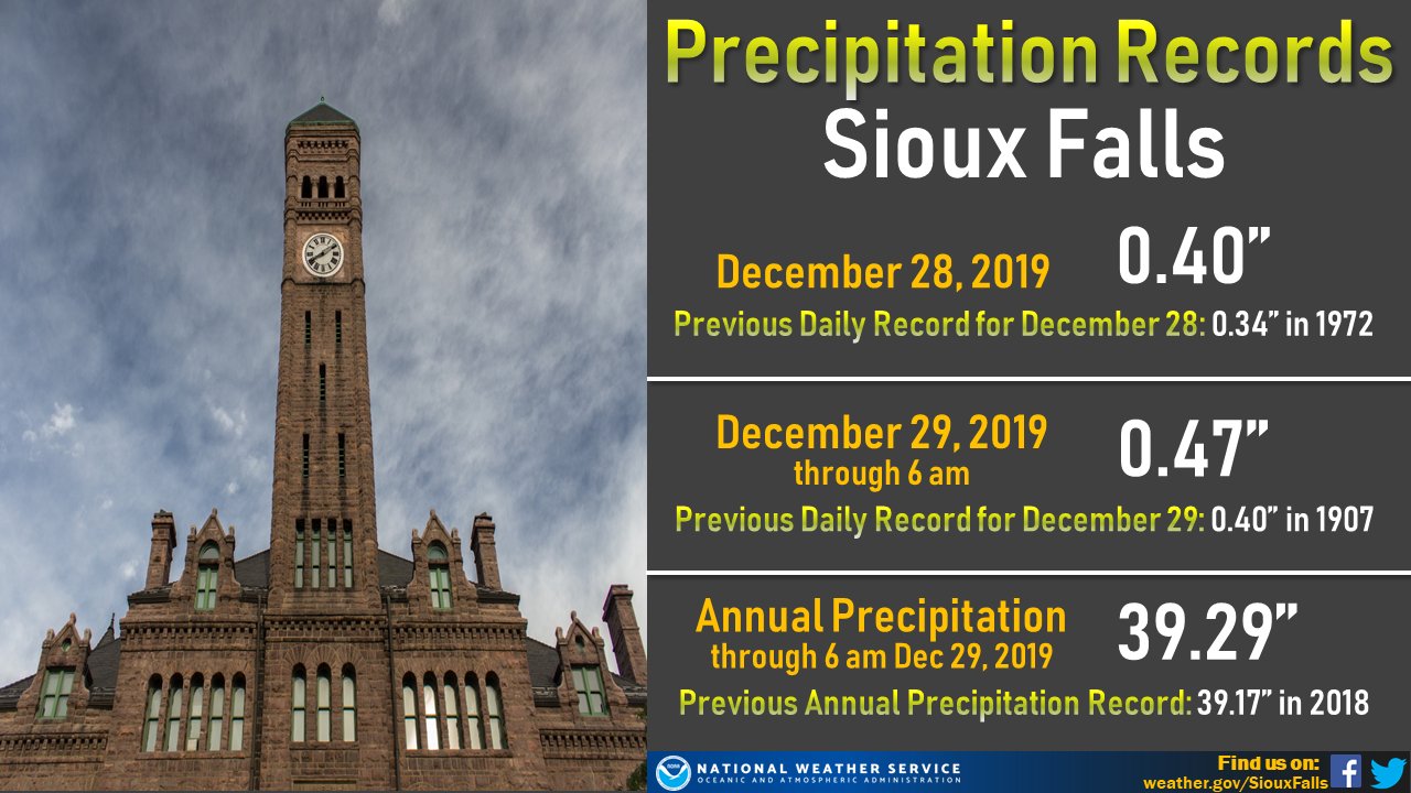
A major and long-lasting winter storm impacted the region the night of Friday, December 27th through Monday, December 30th, bringing periods of moderate to heavy snowfall, wintry mix (rain, freezing rain, sleet) and strong winds. The highest total snowfall amounts recorded were around 16 inches in parts of Gregory, Charles Mix, and Douglas Counties in south central South Dakota. Strong winds around 50 to 55 mph and falling snow caused blizzard conditions and significant blowing/drifting snow across portions of east central South Dakota. Some ice accumulation was also recorded across southwest Minnesota. In terms of records, new daily and annual precipitation records were broken at multiple locations. |
 72-Hour Observed Snowfall |
Snow/Wind

PUBLIC INFORMATION STATEMENT
NATIONAL WEATHER SERVICE SIOUX FALLS SD

...PRELIMINARY WEEKEND SNOWFALL REPORTS...

LOCATION                     AMOUNT    TIME/DATE       PROVIDER

...IOWA...

...CLAY COUNTY...
SPENCER 1 N                  2.0 IN    1032 AM 12/30   COOP

...DICKINSON COUNTY...
SPIRIT LAKE 1.7 SW           1.5 IN    0800 AM 12/30   COCORAHS
SPIRIT LAKE 0.6 E            1.4 IN    0700 AM 12/30   COOP

...IDA COUNTY...
BATTLE CREEK 3 NE            0.8 IN    0800 AM 12/30   COOP

...LYON COUNTY...
ROCK RAPIDS                  1.5 IN    0800 AM 12/30   COOP

...OBRIEN COUNTY...
SANBORN                      2.1 IN    0800 AM 12/30   COOP
SHELDON                      0.6 IN    0700 AM 12/30   COOP

...PLYMOUTH COUNTY...
REMSEN                       0.6 IN    1100 AM 12/30   COOP

...SIOUX COUNTY...
SIOUX CENTER                 2.5 IN    0630 AM 12/30   COOP
HULL                         2.0 IN    0700 AM 12/30   PUBLIC
ORANGE CITY                  1.2 IN    0700 AM 12/30   COOP

...WOODBURY COUNTY...
SIOUX CITY ANG               1.0 IN    0600 AM 12/30   COOP
SIOUX CITY OFFICIAL NWS      0.6 IN    0600 AM 12/30   NWS

...MINNESOTA...

...COTTONWOOD COUNTY...
WINDOM 2.6 NW                2.4 IN    0800 AM 12/30   COOP

...JACKSON...
LAKEFIELD 2 NE               1.8 IN    0700 AM 12/30   COOP

...LINCOLN COUNTY...
HENDRICKS 8.0 SE             4.3 IN    0700 AM 12/30   COCORAHS

...LYON COUNTY...
MARSHALL                     6.0 IN    0800 AM 12/30   COOP
MARSHALL 0.6 S               5.8 IN    0700 AM 12/30   COCORAHS

...MURRAY COUNTY...
CURRIE 5 N                   5.0 IN    0926 AM 12/30   AMATEUR RADIO

...NOBLES COUNTY...
WORTHINGTON 2 NNE            2.0 IN    0700 AM 12/30   COOP

...PIPESTONE COUNTY...
EDGERTON 0.2 WSW             2.0 IN    0600 AM 12/30   COCORAHS

...NEBRASKA...

...DIXON COUNTY...
CONCORD                      0.8 IN    0500 PM 12/29   COOP

...SOUTH DAKOTA...

...BEADLE COUNTY...
HURON 1.1 NNE               14.5 IN    0600 AM 12/30   COCORAHS
HURON OFFICIAL NWS           8.0 IN    0600 AM 12/30   NWS

...BON HOMME COUNTY...
TYNDALL                      6.6 IN    0800 AM 12/30   COOP

...BROOKINGS COUNTY...
BRUCE 5.3 W                  10.2 IN   0800 AM 12/30   COCORAHS
BROOKINGS 0.2 SSW            7.7 IN    0700 AM 12/30   COCORAHS

...BRULE COUNTY...
CHAMBERLAIN 0.3 W            7.2 IN    0530 AM 12/30   COCORAHS
CHAMBERLAIN 7.5 SSW          7.2 IN    0600 AM 12/30   COCORAHS

...CHARLES MIX COUNTY...
LAKE ANDES 2.4 N             16.0 IN   0900 AM 12/30   COCORAHS
WAGNER 0.8 NW                15.5 IN   0700 AM 12/30   COCORAHS
DANTE 3.1 S                  15.0 IN   0700 AM 12/30   COCORAHS

...DAVISON COUNTY...
MITCHELL                     15.0 IN   0200 PM 12/30   COOP

...DAVISON COUNTY...
ARMOUR 2 S                   15.8 IN   0523 AM 12/30   EM
ARMOUR 4.6 W                 15.5 IN   0700 AM 12/30   COCORAHS

...GREGORY COUNTY...
HERRICK 8.2 SSW              16.0 IN   0700 AM 12/30   COCORAHS
BURKE 10.5 SSE               14.0 IN   0700 AM 12/30   COCORAHS
BURKE 4.2 SW                 13.0 IN   0700 AM 12/30   COCORAHS
DALLAS 8.8 S                 7.0 IN    0700 AM 12/30   COCORAHS

...HUTCHINSON COUNTY...
EMERY 10.8 S                 7.3 IN    0600 AM 12/30   COCORAHS

...KINGSBURY COUNTY...
DE SMET 0.2 SSE              7.0 IN    0700 AM 12/30   COCORAHS

...LAKE COUNTY...
2.4 N CHESTER                6.5 IN    0700 AM 12/30   COOP

...LINCOLN COUNTY...
CANTON                       3.6 IN    0700 AM 12/30   COOP

...MCCOOK COUNTY...
MONTROSE 5.8 NW              6.0 IN    0700 AM 12/30   COCORAHS

...MINNEHAHA COUNTY...
HARTFORD 6.4 S               7.5 IN    0800 AM 12/30   COCORAHS
SIOUX FALLS 3.9 SW           5.8 IN    0700 AM 12/30   COCORAHS
SIOUX FALLS 3ESE             4.4 IN    0700 AM 12/30   UCOOP
SIOUX FALLS NWS              3.8 IN    0600 AM 12/30   NWS

...TURNER COUNTY...
HURLEY 0.2 S                 3.8 IN    0600 AM 12/30   COCORAHS

...YANKTON COUNTY...
YANKTON 2 E                  4.0 IN    0630 AM 12/30   COOP

OBSERVATIONS ARE COLLECTED FROM A VARIETY OF SOURCES WITH VARYING
EQUIPMENT AND EXPOSURES. WE THANK ALL VOLUNTEER WEATHER OBSERVERS
FOR THEIR DEDICATION. NOT ALL DATA LISTED ARE CONSIDERED OFFICIAL.

$$

Photos & Video
Snow, Blowing/Drifting Snow and Ice
 |
 |
 |
 |
| Heavy snowfall 5 miles south of Mitchell, SD. (Source: Becky Riggs) |
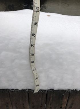
Around a foot of snow fell near Mitchell, SD (Source: Becky Riggs) |
Snowfall reports in Brookings, SD (Source: Shawn Carter) |
Blowing and drifting snow in Spirit Lake, IA (Source: Dickinson County Emergency Manager) |
 |
 |
 |
| Heavy snowfall with significant drifting in Mitchell (Source: Brandon Vilhauer) |
Ice accumulated on tree branches in Ruthon, MN (Source: Pete Bouman) |
Blowing and drifting snow in Minnehaha County (SD) (Source: Minnehaha Sheriff) |
Radar
Radar and Satellite
 |
 |
| Hourly Radar Loop from Friday, December 27th to Monday, December 30th |
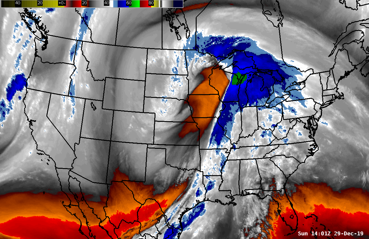
GOES-16 Water Vapor Satellite Loop showing a mature storm structure over the Upper Midwest and High Plains (Satellite Loop 12/29 from 8am - 10 am) |
Precipitation Records
 |
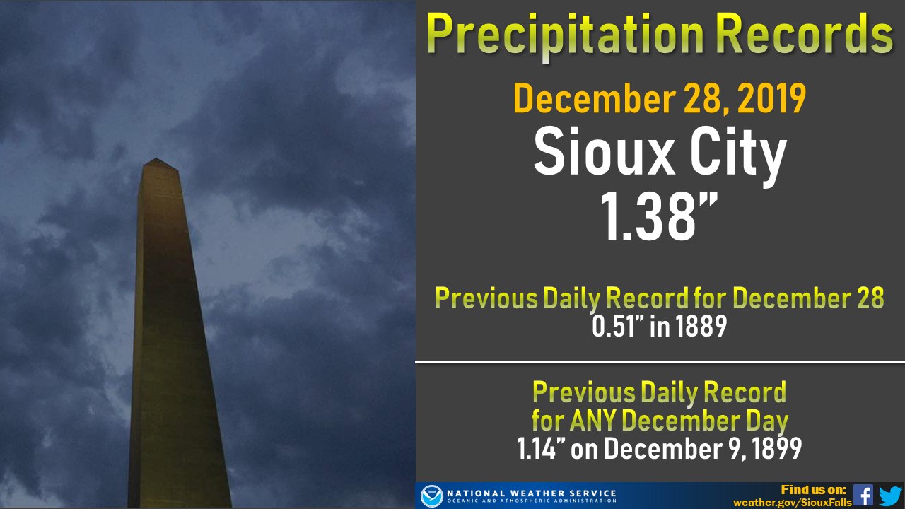 |
| Precipitation Records in Sioux Falls for December 28th & 29th | New Daily Rainfall Records for Sioux City on December, 28th |
 |
Media use of NWS Web News Stories is encouraged! Please acknowledge the NWS as the source of any news information accessed from this site. |
|


 Weather Story
 Weather Map
 Local Radar
 Follow us on YouTube