Overview
|
Two large areas of thunderstorms developed during the evening hours of Saturday, July 16th. Initial thunderstorm development took place across portions of eastern South Dakota and western Minnesota, dropping southward along the Buffalo Ridge region during the late evening hours. The second area of storms entered the local area from the West, first developing across parts of the Black Hills region. These two systems produced strong damaging winds, some large hail, and torrential rainfall. One storm that passed near Clark, SD and then dropped through the Lake Poinsett area produced a tornado near Clark. Strong damaging winds moving through the Lake Poinsett and Volga areas toppled several campers and many large trees. As storms from the West moved into the region, they had a tendency to produce widespread 40 to 60 mph winds. In some locations, very localized bursts of stronger winds produced damage, including in the areas of Canton, SD and near George, IA. Heavy rainfall was also a major threat for portions of southwest Minnesota and adjacent areas of Iowa. 3 to 5 inches of rain fell along the Buffalo Ridge, producing flooding and flash flooding in a few locations. Flash flood warnings were issued in several locations. These storms were also prolific lightning producers, damaging several trees. In fact, as storms approached the midnight hour, nearly 14,000 lightning pulses were detected within a 15 minute period across the Tri-State area. |
 Animation of Storms July 16-17, 2016 |
 |
 |
 |
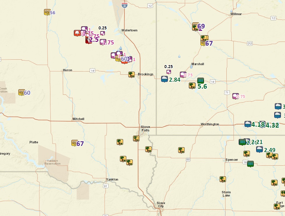
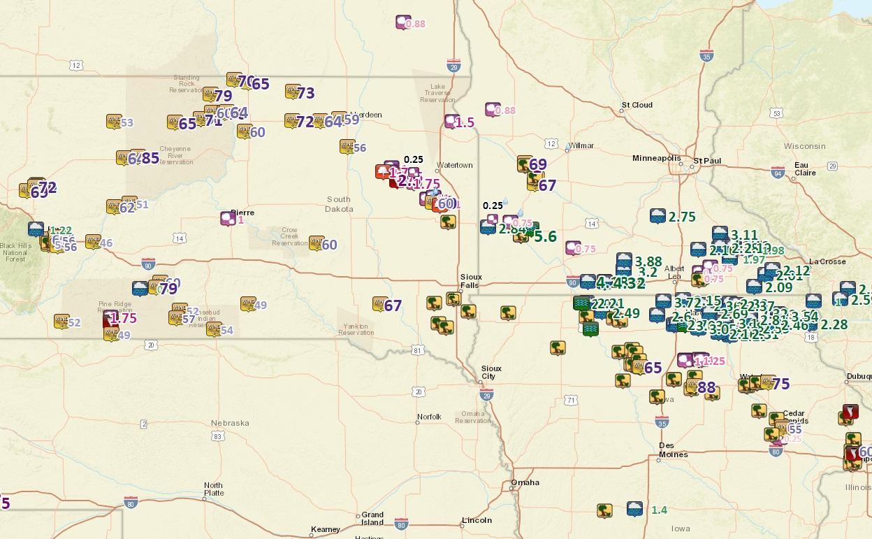
| Peak Wind Gusts Reported | Regional Severe and Tornado Warnings | Regional Flash Flood Warnings |
Storm Reports
Click for an interactive display of storm reports.
 |
 |
| Local Storm Reports - Local Version | Local Storm Reports - Regional Version |
| Report Time | County | Location | ST | Event Type | Mag. | Source | Remark |
| Sun Jul 17 2016 02:50:00 GMT-0500 (Central Daylight Time) | Kingsbury | 5 NE Badger | SD | TSTM WND GST | 70 | public | social media report. |
| Sun Jul 17 2016 03:21:00 GMT-0500 (Central Daylight Time) | Brookings | 8 ENE Badger | SD | FUNNEL CLOUD | 0 | trained spotter | funnel halfway to ground...report from spotter 1 n of oakwood state park. |
| Sun Jul 17 2016 03:36:00 GMT-0500 (Central Daylight Time) | Lyon | Russell | MN | HAIL | 0.75 | trained spotter | . |
| Sun Jul 17 2016 03:50:00 GMT-0500 (Central Daylight Time) | Brookings | 7 NNW Bruce | SD | HAIL | 1 | trained spotter | social media report. |
| Sun Jul 17 2016 03:55:00 GMT-0500 (Central Daylight Time) | Brookings | Volga | SD | TSTM WND DMG | 0 | law enforcement | tree down in volga...time estimated from radar. |
| Sun Jul 17 2016 03:55:00 GMT-0500 (Central Daylight Time) | Cottonwood | 6 NNW Mountain Lake | MN | HAIL | 0.75 | trained spotter | . |
| Sun Jul 17 2016 04:21:00 GMT-0500 (Central Daylight Time) | Hutchinson | Parkston | SD | TSTM WND GST | 67 | mesonet | sdsu site. |
| Sun Jul 17 2016 04:45:00 GMT-0500 (Central Daylight Time) | Murray | 3 SSW Garvin | MN | TSTM WND DMG | 0 | public | 4 inch branches down |
| Sun Jul 17 2016 05:04:00 GMT-0500 (Central Daylight Time) | Turner | Parker | SD | TSTM WND DMG | 0 | emergency mngr | roof blown off building...time estimated from radar. |
| Sun Jul 17 2016 05:08:00 GMT-0500 (Central Daylight Time) | Turner | Viborg | SD | TSTM WND DMG | 0 | emergency mngr | 3 inch diameter tree branch down...time estimated from radar. |
| Sun Jul 17 2016 05:14:00 GMT-0500 (Central Daylight Time) | Turner | Centerville | SD | TSTM WND DMG | 0 | emergency mngr | 4 to 6 inch diameter tree branches down...time estimated from radar. |
| Sun Jul 17 2016 05:20:00 GMT-0500 (Central Daylight Time) | Lincoln | Tea | SD | TSTM WND DMG | 0 | public | metal stop sign pole snapped...social media report...time estimated from radar. |
| Sun Jul 17 2016 05:30:00 GMT-0500 (Central Daylight Time) | Lincoln | 1 W Canton | SD | TSTM WND DMG | 0 | public | report and photos of large tree damage in portions of canton. minor shingle damage. |
| Sun Jul 17 2016 05:30:00 GMT-0500 (Central Daylight Time) | Lincoln | Lake Benton | MN | HEAVY RAIN | 2.84 | co-op observer | 2.84 inches in under 3 hours. |
| Sun Jul 17 2016 05:33:00 GMT-0500 (Central Daylight Time) | Lyon | Tracy | MN | FLASH FLOOD | 0 | amateur radio | water above street curbs...fire department barricading flooded streets. |
| Sun Jul 17 2016 06:08:00 GMT-0500 (Central Daylight Time) | Lyon | 4 NW Matlock | IA | TSTM WND DMG | 0 | public | reports of tree and crop damage. also damage to machine shed structure. report from social media. . |
| Sun Jul 17 2016 07:00:00 GMT-0500 (Central Daylight Time) | Murray | 3 SSW Garvin | MN | HEAVY RAIN | 5.6 | public | storm total rainfall |
| Sun Jul 17 2016 07:02:00 GMT-0500 (Central Daylight Time) | Buena Vista | 2 E Linn Grove | IA | TSTM WND DMG | 0 | public | 3 empty grain silos moved off their footings and numerous trees uprooted . |
Rain Reports
 |
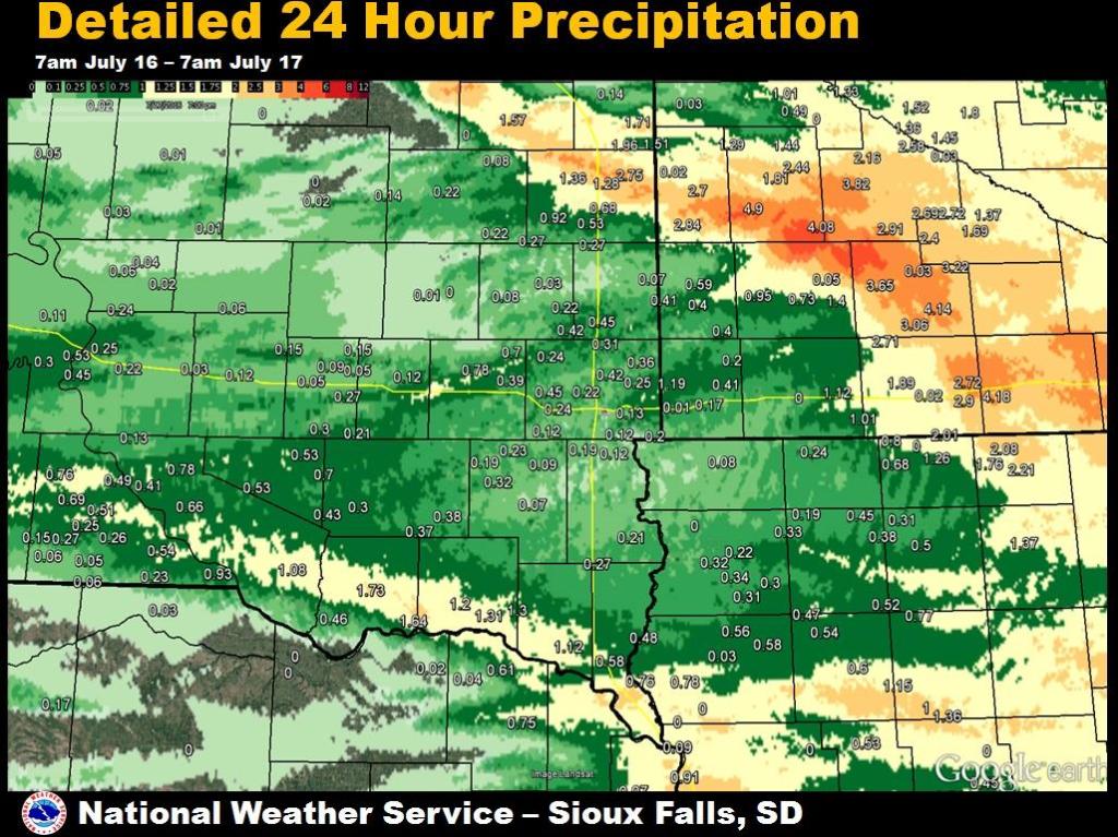 |
| 24 Hour Observed Precipitation Totals | Detailed 24 Hour Precipitation Totals |
| Station Name | County | State | Provider | Precipitation (inches) | |
| Redwood Rvr | Lyon | MN | GOES | 4.9 | |
| Windom Muni Airport | Cottonwood | MN | AWOS | 4.14 | |
| Tracy Airport | Lyon | MN | AWOS | 4.08 | |
| Storden | Cottonwood | MN | COCORAHS | 3.65 | |
| 1 ESE White | Brookings | SD | COCORAHS | 3.23 | |
| 1 SW Comfrey | Cottonwood | MN | COCORAHS | 3.22 | |
| 2 WNW Windom | Cottonwood | MN | HADS | 3.06 | |
| Jackson Airport | Jackson | MN | AWOS | 2.9 | |
| Lake Benton | Lincoln | MN | UCOOP | 2.84 | |
| 1 SW White | Brookings | SD | COCORAHS | 2.75 | |
| Jackson | Jackson | MN | USGS | 2.72 | |
| 2 NNE Heron Lake | Jackson | MN | COCORAHS | 2.71 | |
| 2 W Arco | Lincoln | MN | CWOP | 2.7 | |
| White 0.4 WNW | Brookings | SD | COCORAHS | 2.69 | |
| Marshall | Lyon | MN | COOP | 2.57 | |
| Marshall | Lyon | MN | CWOP | 2.54 | |
| Marshall 0.6 S | Lyon | MN | COCORAHS | 2.44 | |
| Aurora 7.5 N | Brookings | SD | COCORAHS | 2.26 | |
| Spirit Lake | Dickinson | IA | GOES | 2.01 | |
| Marshall Municipal-ryan Field Airport | Lyon | MN | AWOS | 2 | |
| 3 SW Toronto | Brookings | SD | COCORAHS | 1.96 | |
| Lakefield | Jackson | MN | COOP | 1.89 | |
| Marshall | Lyon | MN | GOES | 1.81 | |
| Tyndall | Bon Homme | SD | COOP | 1.73 | |
| 3 S Tabor | Bon Homme | SD | COCORAHS | 1.64 | |
| 2 SE Astoria | Brookings | SD | COCORAHS | 1.51 | |
| 2 ENE Ghent | Lyon | MN | COCORAHS | 1.44 | |
| Avoca | Murray | MN | UCOOP | 1.4 | |
| Bruce | Brookings | SD | COCORAHS | 1.36 | |
| 2 WSW Lakeside | Buena Vista | IA | COCORAHS | 1.36 | |
| 2 SE Yankton | Yankton | SD | COOP | 1.31 | |
| 1 W Gayville | Yankton | SD | COCORAHS | 1.3 | |
| Minneota | Lyon | MN | CWOP | 1.29 | |
| 5 N Brookings | Brookings | SD | COCORAHS | 1.28 | |
| Spirit Lake | Dickinson | IA | CWOP | 1.26 | |
| Yankton Chan Gurney Municipal Airport | Yankton | SD | AWOS | 1.2 | |
| Garretson 4.2 SSE | Minnehaha | SD | COCORAHS | 1.19 | |
| Alta | Buena Vista | IA | COCORAHS | 1.15 | |
| Worthington Airport | Nobles | MN | AWOS | 1.12 | |
| 1 NNE Vermillion | Clay | SD | COCORAHS | 1.12 | |
| Wagner | Charles Mix | SD | COCORAHS | 1.08 | |
| 2 NE Brookings | Brookings | SD | COOP | 1.08 | |
| Brookings Municipal Airport | Brookings | SD | AWOS | 1.08 | |
| 1 NNE Round Lake | Jackson | MN | CWOP | 1.01 | |
| 3 SSE Tabor | Bon Homme | SD | COCORAHS | 1 | |
| Storm Lake Airport | Buena Vista | IA | AWOS | 0.96 | |
| Lake Wilson | Murray | MN | COOP | 0.95 | |
| Pickstown | Charles Mix | SD | COOP | 0.93 | |
| Volga | Brookings | SD | CWOP | 0.92 | |
| 2 N Vermillion | Clay | SD | HADS | 0.83 | |
| Platte | Charles Mix | SD | CWOP | 0.82 | |
| Lake Park | Dickinson | IA | COCORAHS | 0.8 | |
| Millnerville | Plymouth | IA | UCOOP | 0.78 | |
| 1 E Platte | Charles Mix | SD | COCORAHS | 0.78 | |
| Hornick | Woodbury | IA | HADS | 0.78 | |
| Salem 5ne | McCook | SD | COOP | 0.78 | |
| Linn Grove | Buena Vista | IA | HADS | 0.77 | |
| 4 SSE Westfield | Plymouth | IA | RAWS | 0.76 | |
| Gregory 8.7 N | Gregory | SD | COCORAHS | 0.76 | |
| Slayton Municipal Airport | Murray | MN | AWOS | 0.73 | |
| 5 NW Montrose | McCook | SD | COCORAHS | 0.7 | |
| 1 S Brookings | Brookings | SD | COCORAHS | 0.7 | |
| Parkston 6.5 WSW | Hutchinson | SD | COCORAHS | 0.7 | |
| 4 E Gregory | Gregory | SD | COCORAHS | 0.69 | |
| Brookings | Brookings | SD | COCORAHS | 0.69 | |
| Brookings 0.8 ESE | Brookings | SD | COCORAHS | 0.68 | |
| 3 SSE Lake Park | Dickinson | IA | COCORAHS | 0.68 | |
| 1 SW Brookings | Brookings | SD | COCORAHS | 0.68 | |
| Lake Andes Raws | Charles Mix | SD | RAWS | 0.66 | |
| Cherokee Municipal Airport | Cherokee | IA | AWOS | 0.6 | |
| Pipestone | Pipestone | MN | RAWS | 0.59 | |
| 2 W Westfield | Union | SD | COCORAHS | 0.58 | |
| Remsen No. 2 | Plymouth | IA | COOP | 0.58 | |
| 2 NNW Le Mars | Plymouth | IA | CWOP | 0.56 | |
| Sioux Gateway Airport | Woodbury | IA | ASOS | 0.56 | |
| Bonesteel | Gregory | SD | COCORAHS | 0.54 | |
| 2 NNE Cleghorn | Cherokee | IA | COCORAHS | 0.54 | |
| Le Mars | Plymouth | IA | COCORAHS | 0.54 | |
| 7 WSW Dimock | Douglas | SD | COCORAHS | 0.53 | |
| Armour 4.6 W | Douglas | SD | COCORAHS | 0.53 | |
| Holstein | Ida | IA | COOP | 0.53 | |
| Chamberlain | Brule | SD | COCORAHS | 0.53 | |
| Holly Springs 1nw | Woodbury | IA | COOP | 0.53 | |
| 2 SSW Brookings | Brookings | SD | COCORAHS | 0.53 | |
| Peterson | Clay | IA | COOP | 0.52 | |
| Burke 2.4 NE | Gregory | SD | COCORAHS | 0.51 | |
| 3 WSW Spencer | Clay | IA | HADS | 0.5 | |
| 12 NE Burke | Gregory | SD | COCORAHS | 0.49 | |
| Akron | Plymouth | IA | HADS | 0.48 | |
| 4 N Cleghorn | Cherokee | IA | COCORAHS | 0.47 | |
| Springfield 7.6 WNW | Bon Homme | SD | COCORAHS | 0.46 | |
| 6 S Oacoma | Brule | SD | COCORAHS | 0.45 | |
| 1 NW Hartley | O'Brien | IA | CWOP | 0.45 | |
| 5 E Chester | Moody | SD | COCORAHS | 0.45 | |
| 4 ESE Delmont | Hutchinson | SD | COCORAHS | 0.43 | |
| 5 ESE Chester | Moody | SD | HADS | 0.42 | |
| 2 NE Crooks | Minnehaha | SD | COCORAHS | 0.42 | |
| Pipestone | Pipestone | MN | UCOOP | 0.41 | |
| Luverne | Rock | MN | HADS | 0.41 | |
| 7 WSW Platte | Charles Mix | SD | HADS | 0.41 | |
| Edgerton | Pipestone | MN | COCORAHS | 0.4 | |
| Pipestone | Pipestone | MN | HADS | 0.4 | |
| Montrose 2.4 E | McCook | SD | COCORAHS | 0.39 | |
| Everly | Clay | IA | COCORAHS | 0.38 | |
| 4 SE Olivet | Hutchinson | SD | HADS | 0.37 | |
| 3 N Sioux City | Woodbury | IA | CWOP | 0.36 | |
| 6 ESE Baltic | Minnehaha | SD | GOES | 0.36 | |
| Orange City | Sioux | IA | COOP | 0.34 | |
| Spencer Municipal Airport | Clay | IA | ASOS | 0.33 | |
| Sheldon | O'Brien | IA | COOP | 0.33 | |
| 4 S Marion | Turner | SD | COCORAHS | 0.32 | |
| 2 SE Sioux Center | Sioux | IA | COOP | 0.32 | |
| 4 W Sioux Falls | Minnehaha | SD | CWOP | 0.32 | |
| 2 S Orange City | Sioux | IA | COCORAHS | 0.31 | |
| 3 WNW Everly | Clay | IA | COOP | 0.31 | |
| Dell Rapids | Minnehaha | SD | COCORAHS | 0.31 | |
| 5 NNW Tripp | Hutchinson | SD | COCORAHS | 0.3 | |
| 10 W Dimock | Douglas | SD | COCORAHS | 0.3 | |
| Alton | Sioux | IA | HADS | 0.3 | |
| 4 SW Burke | Gregory | SD | COCORAHS | 0.27 | |
| Beresford | Union | SD | COCORAHS | 0.27 | |
| 8 S Brookings | Moody | SD | COCORAHS | 0.27 | |
| Arlington 9.0 SSW | Kingsbury | SD | COCORAHS | 0.27 | |
| 6 SSE Mitchell | Davison | SD | COCORAHS | 0.27 | |
| Herrick | Gregory | SD | COCORAHS | 0.26 | |
| 5 ESE Baltic | Minnehaha | SD | COCORAHS | 0.25 | |
| 2 SE Burke | Gregory | SD | COCORAHS | 0.25 | |
| Chamberlain Municipal Airport | Brule | SD | AWOS | 0.25 | |
| Chamberlain 7.5 NNE | Brule | SD | COCORAHS | 0.24 | |
| Sibley | Osceola | IA | COOP | 0.24 | |
| 2 ENE Hartford | Minnehaha | SD | HADS | 0.24 | |
| 7 WNW Colton | Minnehaha | SD | HADS | 0.24 | |
| Butte | Gregory | SD | CWOP | 0.23 | |
| Marion | Turner | SD | COCORAHS | 0.23 | |
| 2 NNW Sioux Center | Sioux | IA | COCORAHS | 0.23 | |
| 2 SSW Crooks | Minnehaha | SD | HADS | 0.22 | |
| Oldham 0.9 E | Kingsbury | SD | COCORAHS | 0.22 | |
| 4 SE Pukwana | Brule | SD | COCORAHS | 0.22 | |
| Chester 2n | Lake | SD | COOP | 0.22 | |
| Sioux Center | Sioux | IA | CWOP | 0.22 | |
| De Smet | Kingsbury | SD | COCORAHS | 0.22 | |
| Sioux Falls 3ese | Minnehaha | SD | UCOOP | 0.21 | |
| Hudson 8.3 WNW | Lincoln | SD | COCORAHS | 0.21 | |
| 2 W Ethan | Davison | SD | COCORAHS | 0.21 | |
| 3 ESE Sioux Falls | Minnehaha | SD | COCORAHS | 0.21 | |
| 4 NNE Tea | Minnehaha | SD | CWOP | 0.21 | |
| Sd Sioux Falls 14 NNE | Minnehaha | SD | GOES | 0.21 | |
| 3 SW Sioux Falls | Minnehaha | SD | COCORAHS | 0.2 | |
| 1 NE Rowena | Minnehaha | SD | COCORAHS | 0.2 | |
| Sioux Center | Sioux | IA | CWOP | 0.2 | |
| Rock Rvr | Rock | MN | GOES | 0.2 | |
| Marion | Turner | SD | COOP | 0.19 | |
| Sheldon Airport | O'Brien | IA | AWOS | 0.19 | |
| 1 NNW Tea | Lincoln | SD | COCORAHS | 0.19 | |
| 3 W Sioux Falls | Minnehaha | SD | COCORAHS | 0.18 | |
| 5 SW Sioux Falls | Minnehaha | SD | UCOOP | 0.18 | |
| Luverne Airport | Rock | MN | AWOS | 0.17 | |
| Huron | Beadle | SD | HADS | 0.16 | |
| Sioux Falls Airport | Minnehaha | SD | ASOS | 0.16 | |
| 5 N Mt Vernon | Davison | SD | GOES | 0.15 | |
| Mitchell Municipal Airport | Davison | SD | ASOS | 0.15 | |
| 8 S Dallas | Gregory | SD | COCORAHS | 0.15 | |
| 3 W Sioux Falls | Minnehaha | SD | HADS | 0.15 | |
| Sioux Falls Nws | Minnehaha | SD | COOP | 0.15 | |
| Sioux Falls 3.4 WSW | Minnehaha | SD | COCORAHS | 0.14 | |
| 1 SW Sioux Falls | Minnehaha | SD | COCORAHS | 0.14 | |
| Wall Lake | Minnehaha | SD | COCORAHS | 0.13 | |
| 2 NE Academy | Charles Mix | SD | COOP | 0.13 | |
| Sioux Falls Oak View Library | Minnehaha | SD | UCOOP | 0.13 | |
| 4 S Sioux Falls | Lincoln | SD | COCORAHS | 0.12 | |
| Plankinton 3.8 W | Aurora | SD | COCORAHS | 0.12 | |
| Alexandria 6.4 N | Hanson | SD | COCORAHS | 0.12 | |
| Sioux Falls 4.5 SSW | Lincoln | SD | COCORAHS | 0.12 | |
| 4 SSE Sioux Falls | Lincoln | SD | UCOOP | 0.12 | |
| 3 SSW Sioux Falls | Lincoln | SD | CWOP | 0.12 | |
| Wall Lake | Minnehaha | SD | HADS | 0.12 | |
| Sioux Falls Harmondon Park | Minnehaha | SD | UCOOP | 0.1 | |
| 4 SE Sioux Falls | Minnehaha | SD | COCORAHS | 0.1 | |
| Sioux Falls 4.1 SSE | Lincoln | SD | COCORAHS | 0.09 | |
| Mitchell 1.1 N | Davison | SD | COCORAHS | 0.09 | |
| 1 SW Sioux City | Dakota | NE | HADS | 0.09 | |
| 3 NNE Parker | Turner | SD | HADS | 0.09 | |
| 2 E Madison | Lake | SD | COOP | 0.08 | |
| Lake Preston 10.5 NNE | Kingsbury | SD | COCORAHS | 0.08 | |
| Rock River Below Rock Rapids | Lyon | IA | UCOOP | 0.08 | |
| 2 SW Hubbard | Dakota | NE | COCORAHS | 0.07 | |
| Flandreau | Moody | SD | UCOOP | 0.07 | |
| 1 NE Sioux Falls | Minnehaha | SD | USARMY-COE | 0.07 | |
| Hurley | Turner | SD | COCORAHS | 0.07 | |
| 7 WNW Naper | Gregory | SD | COCORAHS | 0.06 | |
| 9 SSW Wessington Springs | Jerauld | SD | COCORAHS | 0.06 | |
| 3 SSW Sioux Falls | Minnehaha | SD | HADS | 0.06 | |
| 9 NNW Mills | Gregory | SD | COCORAHS | 0.06 | |
| Burke 10.5 SSE | Gregory | SD | COCORAHS | 0.05 | |
| 2 W Dovray | Murray | MN | MNDOT | 0.05 | |
| Mitchell 5.3 WSW | Davison | SD | COCORAHS | 0.05 | |
| Mitchell | Davison | SD | COOP | 0.05 | |
| 4 ENE Jeffers | Cottonwood | MN | MNDOT | 0.03 | |
| Madison Airport | Lake | SD | AWOS | 0.03 | |
| White Lake | Aurora | SD | COOP | 0.03 | |
| 3 S Hendricks | Lincoln | MN | MNDOT | 0.02 | |
| Le Mars Airport | Plymouth | IA | AWOS | 0.02 | |
| 1 WNW Lake Benton | Lincoln | MN | MNDOT | 0.02 | |
| 1 S Huron | Beadle | SD | COCORAHS | 0.02 | |
| 3 SE Lakefield | Jackson | MN | MNDOT | 0.02 | |
| Howard 5.3 W | Miner | SD | COCORAHS | 0.01 | |
| Beaver Creek | Rock | MN | MNDOT | 0.01 | |
 |
Media use of NWS Web News Stories is encouraged! Please acknowledge the NWS as the source of any news information accessed from this site. |
|


 Weather Story
 Weather Map
 Local Radar