Between 3 am and 7 am on Monday, June 22, a line of severe thunderstorms moved through southeast South Dakota, southwest Minnesota and northwest Iowa. Damage to trees and a few buildings was reported in several locations including Marcus, IA, Sioux Falls, SD, and Hartford, SD. The worst damage reported to the National Weather Service occurred in Garretson, SD and near Sheldon, IA.
Damage assessment surveys were done for both locations by the National Weather Service in Sioux Falls. It was determined that the damage in both locations was the result of straightline winds associated with the line of thunderstorms moving through the area. In both cases, wind speeds were estimated to be between 90 and 100 mph. These winds did damage to trees and buildings in both communities.
Below are images of radar and pictures from Garretson, South Dakota early on June 22.
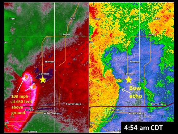
This radar picture is from 4:54 am CDT. At this time there were two areas of stronger winds detected by the radar - one was approximately 4 miles west of Garretson and the other about 4 miles southwest of Garretson. The winds speeds being detected were 108 mph as the bow echo approached Garretson. These winds were being sampled approximately 650 feet above the ground.

This radar picture is from 5 minutes later at 4:59 am CDT. The two circulations appear to have merged or the southern circulation has become the dominant circulation. The radar was detecting winds speeds of 141 mph near 650 feet above the ground. With the accelerating winds, the bow echo become more pronounced east of Garretson. Winds on the ground were estimated at near 100 mph based upon a damage survey.
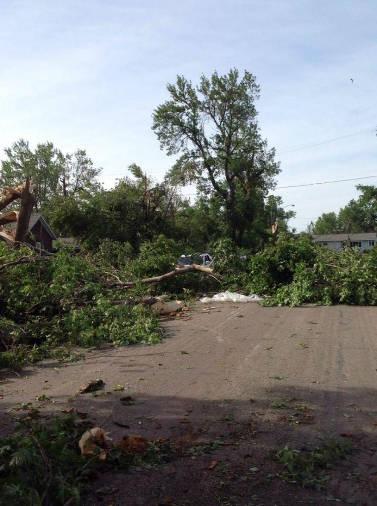
Numerous trees laying on Granite Avenue in Garretson, South Dakota. Wind speeds estimated at 100 mph were responsible for uprooting those trees.
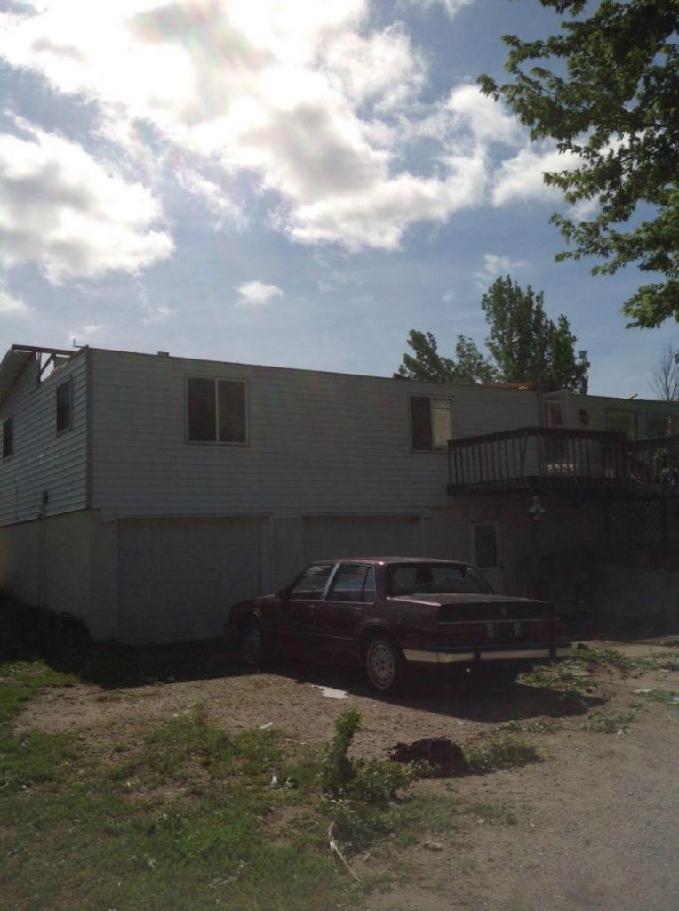
A home lost part of its roof due to 100 mph winds that went through Garretson, South Dakota around 4:58 am CDT on June 22, 2015.
One half hour later, the line of storms approached Sheldon Iowa.
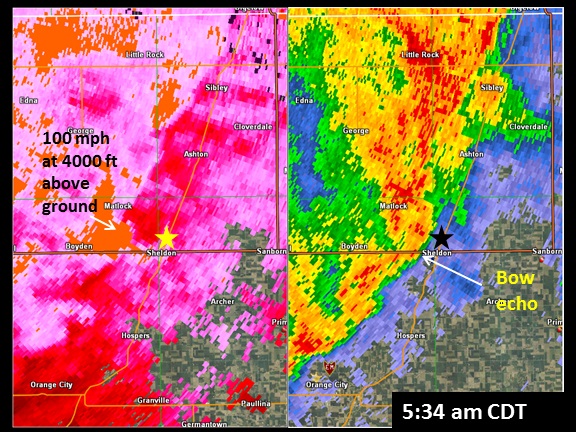
Because Sheldon, Iowa is around 50 miles from the National Weather Service radar in Sioux Falls, the winds being detected were around 4000 ft. As a result, areas of strong winds (colored orange above) were more common than near Garretson, where the radar beam was much closer to the surface. A few minutes before reaching the Sheldon airport, the radar was detecting winds around 100 mph west of Sheldon. A survey of the area showed damage to numerous trees at two farmsteads west of Sheldon. There was also sporadic tree damage at other farms in the area.
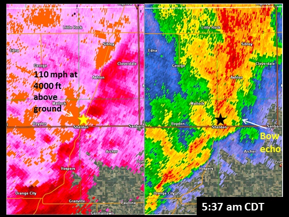
Three minutes later the line of storms moved through Sheldon with the strongest winds being detected just north of town near the airport. Again, similar to Garretson, SD, the radar reflectivity began to "bow out" as the winds reached the surface and accelerated the line to the east. The radar at this time was detecting winds around 110 mph, again near 4000 feet above ground. The automated weather station at the airport in Sheldon recorded a wind gust of 95 mph before the unit lost power. In addition, one hangar was destroyed by the winds.
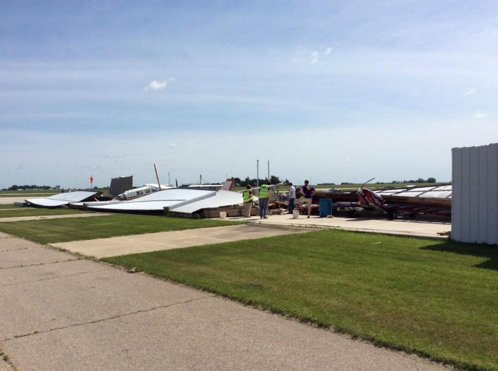
This is a picture of the destroyed hangar at the airport in Sheldon, Iowa. Five planes in the hangar were damaged or destroyed as well. Fortunately, other hangars on the airport property were undamaged by the thunderstorm winds.

Several outbuildings, including this shed, were destroyed at this farm 1 mile west of the Sheldon, Iowa airport. Three power poles were also snapped just to the west of this farmstead. Estimated winds of 90 to 95 mph caused this damage.
Strong winds early in the morning on June 22 actually came in two waves. The first was with the line of thunderstorms (bow echo) which moved quickly through the region. As detailed above, wind speeds with the bow echo ranged up to 100 mph! While very strong, these winds typically only lasted for a few minutes at most.
Intense low pressure developed behind the line of thunderstorms. This feature is called a wake low, and can result in a more prolonged period of strong to severe level winds. Recorded wind speeds with the wake low early this morning ranged up to 81 mph, and in some cases, wind speeds of 50 mph or greater persisted for 20 minutes or more!
PUBLIC INFORMATION STATEMENT
NATIONAL WEATHER SERVICE SIOUX FALLS SD
530 PM CDT MON JUN 22 2015

...WIND REPORTS GREATER THAN 55 MPH RESULTING FROM LINE OF SEVERE
THUNDERSTORMS /BOW ECHO/...

LOCATION                     SPEED     TIME/DATE
GARRETSON                    100 MPH   0458 AM 06/22
2 N SHELDON                  95 MPH    0537 AM 06/22
5 W SIOUX FALLS              82 MPH    0448 AM 06/22
3 WNW ROWENA                 80 MPH    0459 AM 06/22
1 NNE GEORGE                 75 MPH    0520 AM 06/22
3 SW CHAMBERLAIN             73 MPH    0230 AM 06/22
3 NNW SIOUX FALLS            69 MPH    0456 AM 06/22
SPENCER MUNICIPAL AIRPORT    66 MPH    0607 AM 06/22
GARRETSON                    65 MPH    0501 AM 06/22
3 N WINDOM                   62 MPH    0556 AM 06/22
1 SSW PARKSTON               61 MPH    0410 AM 06/22
1 S HARRIS                   60 MPH    0548 AM 06/22
MOUNTAIN LAKE                60 MPH    0602 AM 06/22
4 SSE MOUNTAIN LAKE          60 MPH    0607 AM 06/22
3 SSE LAKE PARK              59 MPH    0600 AM 06/22
BALTIC                       58 MPH    0500 AM 06/22
3 S SALEM                    57 MPH    0418 AM 06/22

...NON-THUNDERSTORM WIND REPORTS GREATER THAN 55 MPH ASSOCIATED WITH INTENSE
LOW PRESSURE WHICH DEVELOPED BEHIND THE LINE OF THUNDERSTORMS /WAKE LOW/...

LOCATION                     SPEED     TIME/DATE
3 NNW DE SMET                81 MPH    0455 AM 06/22
2 N JACKSON                  76 MPH    0714 AM 06/22
2 NNE WORTHINGTON            74 MPH    0655 AM 06/22
3 NNW SIOUX FALLS            73 MPH    0609 AM 06/22
LAKE ANDES RAWS              68 MPH    0441 AM 06/22
3 N WINDOM                   68 MPH    0654 AM 06/22
BALTIC                       67 MPH    0600 AM 06/22
1 W SLAYTON                  67 MPH    0633 AM 06/22
2 W MARSHALL                 66 MPH    0615 AM 06/22
BROOKINGS MUNICIPAL AIRPORT  64 MPH    0535 AM 06/22
BRANDON                      64 MPH    0606 AM 06/22
2 S LUVERNE                  63 MPH    0633 AM 06/22
2 NNE WORTHINGTON            63 MPH    0635 AM 06/22
3 NNW SIOUX FALLS            63 MPH    0545 AM 06/22
1 SSW VERMILLION             60 MPH    0515 AM 06/22
LUVERNE AIRPORT              60 MPH    0614 AM 06/22
2 W BROOKINGS                59 MPH    0555 AM 06/22
WHITE LAKE - SDSU            57 MPH    0400 AM 06/22

OBSERVATIONS ARE COLLECTED FROM A VARIETY OF SOURCES WITH VARYING
EQUIPMENT AND EXPOSURE. NOT ALL DATA LISTED ARE CONSIDERED OFFICIAL.

$$

NWS SIOUX FALLS SD
To see just how expansive this storm system was, check out this interactive regional map and complete listing of storm reports.


 Weather Story
 Weather Map
 Local Radar
 Follow us on YouTube