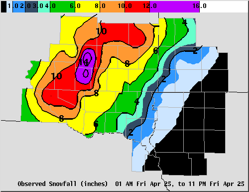
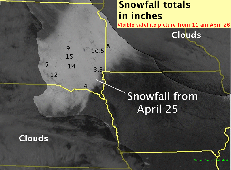
On April 25, a significant spring snowstorm affected much eastern South Dakota into north central Nebraska. While heavy snow in a late April snowstorm is unusual, the features associated with this storm are common in winter storms. But because it was April, much more moisture was available than in mid-winter to produce a swath of heavy snowfall. As can be seen on the graphic and visible satellite picture below, an area extending from south central South Dakota into east central South Dakota received 10 to 15 inches of snow. Much of this snow fell in 6 to 12 hours.
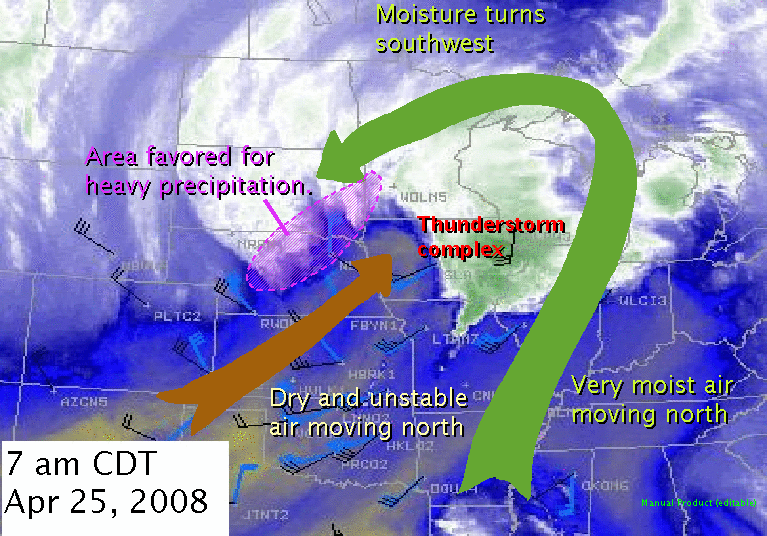
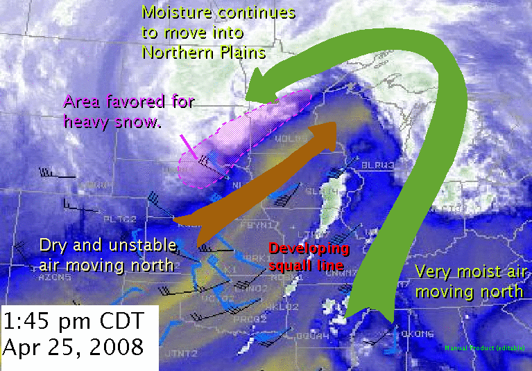
The following image is a water vapor satellite image, which depicts the amount of moisture in the middle to upper levels of the atmosphere. In this image, white and green shades (along with the curving green arrow) indicate moist air, while blue to yellow shades (along with the straight brown arrow) depict much drier air.

During the early morning on Friday, April 25, 2008, you can see dry air moving north into the central plains. This is called the dry slot and is an area of slowly rising but very dry air. It is also an area of very unstable air that can be used for the development of heavy precipitation. As is typical for many spring time systems, an area of thunderstorms developed at the northern edge of the dry slot in eastern Nebraska and western Iowa. These thunderstorms are indicative of the amount of instability present in this area. To the east, very moist air from the Gulf of Mexico was moving north and then being turned cyclonically (counter-clockwise) around the developing cyclone into the Northern Plains and west of the dry slot. At the same time a large area of rain was developing across central Nebraska.
The dry air continued to move rapidly northward into western Iowa by daybreak. At the same time, the very moist air continued to move north and then wraps around to the north and west of a strong upper level low pressure area. This stream of moisture that is moving southwest is known as a TROWAL (TROugh of Warm air ALoft). A TROWAL is a relatively narrow band of relatively warm and moist air aloft that wraps around to the north and west of a mature cyclone. As this moisture moves north and then is turned cyclonically to the southwest, it begins to slowly rise producing an extensive area of clouds and light precipitation. The location of where the TROWAL is adjacent to the dry slot is an area of intense lift (as noted by the purple shading in the image). This is because the additional instability associated with the dry slot as well as the presence of a boundary interacting with the warm and moist air producing intense lift on the northwestern edge of the dry slot. This results in a favored region for heavy and/or prolonged precipitation . During a winter storm, the heaviest snowfall amounts frequently occur along and north of the TROWAL axis.

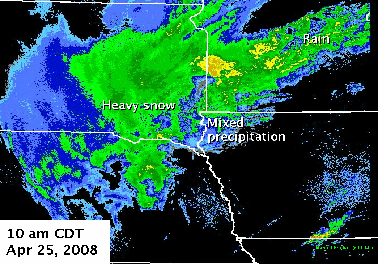
At this same time around daybreak Friday, the above radar image reflects the impact of the dry air seen on the water vapor imagery. There is a lack of precipitation from southeast Nebraska into southwest Iowa. As the moisture in the TROWAL arcs around the thunderstorm complex in eastern Iowa, the moisture is lifted and produces a band of precipitation across southern Minnesota. This band of precipitation broadens and intensifies as it moves into southeast South Dakota and central Nebraska. Unseasonably cold air was drawn into the system from the north, resulting in a transition from a cold rain in southern Minnesota, to a mix of freezing rain and sleet over southeast South Dakota, to a band of heavy snow from south central South Dakota into central Nebraska.
By mid morning, a band of heavy snow had moved into the James River Valley, with a mix of freezing rain and sleet from far eastern South Dakota into southwest Minnesota. The precipitation changed to rain in east central Minnesota. Also note the small thunderstorm in south central Iowa. While not severe, it is indicative the large amount of instability within the dry slot.
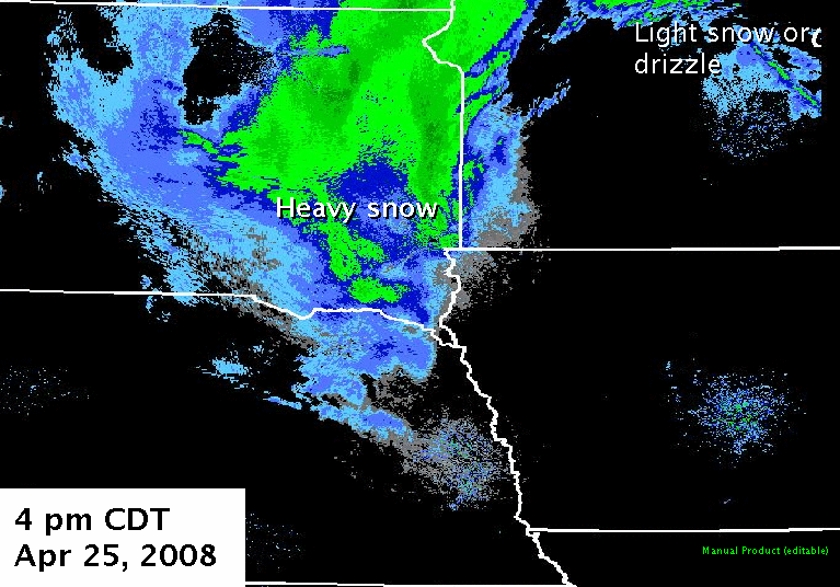
The system continues to evolve through the early afternoon, with very moist air continuing to wrap around the storm into the TROWAL over the Northern Plains. Because the orientation of the TROWAL is parallel to the movement of the upper low, the boundary between the TROWAL and dry slot remained nearly stationary from southeast South Dakota into west central Minnesota. This kept the area favored for heavy snow across the James Valley of South Dakota into northeastern South Dakota. Also notice that the dry slot has moved all the way into western Wisconsin. Convection has begin to develop on the eastern edge of the dry slot.

Radar imagery at the same time displays the broad area of very heavy snow across much of the eastern third of South Dakota, especially near and north of Interstate 90, with mixed precipitation now moving into central Minnesota. Notice the rapid transition from no precipitation over northwest Iowa to very heavy snow to the west of Interstate 29.
The heavy snow has persisted in the same area across eastern South Dakota through the late afternoon, hampering travel and forcing the closure of Interstate 29 north of Highway 14. The snowfall has begun to diminish near the Nebraska border as the TROWAL slowly moves to the northeast.

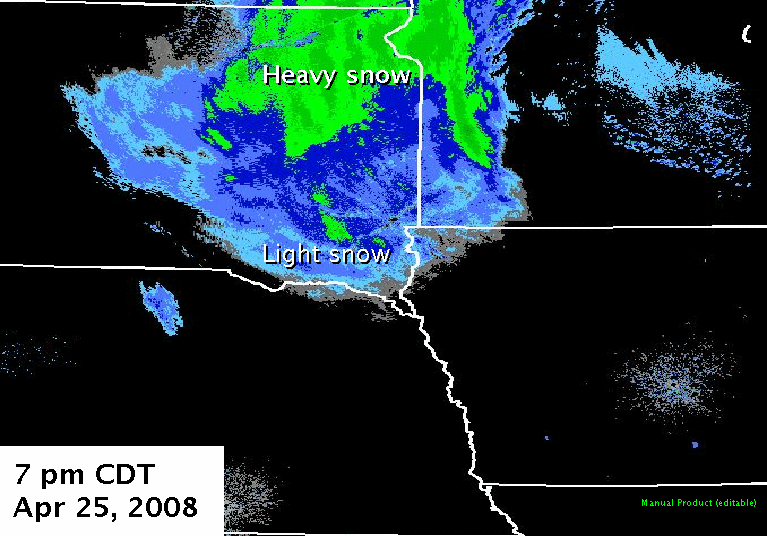
By Friday evening, the TROWAL was located across central and northern Minnesota, with the axis of heavy precipitation shifting north and extending from northeast South Dakota and the lower Red River Valley into north central Minnesota. Note that this is the area where there is sharp boundary separating the very moist air in northwestern Minnesota from the very dry air in eastern Minnseota. Meanwhile, residual moisture is located over eastern South Dakota and northern Nebraska. While the intense lift from the TROWAL moved north, light snow remains across southeast South Dakota, as seen in the radar image below.


 Weather Story
 Weather Map
 Local Radar
 Follow us on YouTube