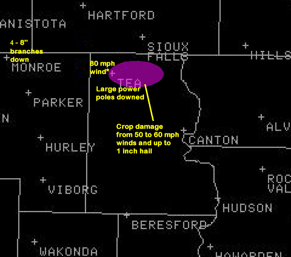
On 18 August 2006, damaging winds associated with a line of thunderstorms moved through northern Lincoln County in southeastern South Dakota. These winds occurred between 12:15 pm and 12:40 pm CDT. Winds were estimated between 50 and 80 mph across the area. Below is a map of some of the damage reported with the downburst. You can click any images for a larger view.
The phenomenom that produced this damage was called a downburst. The figure below shows a depiction of what basically occurs in a downburst. A downburst is caused by bouyancy terms of rising air in a thunderstorm. The rising air within a thunderstorm is considered positively bouyant - i.e. the the air that is rising is warmer than the air around it and accelerates upward. While rising air does cool as it rises, the atmosphere cools even faster and allows the air to continue accelerating upward until reaches heights of 30,000 to 60,000 feet. However, with a downburst, the opposite occurs. Rain from the thunderstorm falls into very dry air located between 10,000 and 20,000 feet. Because the air is dry, the air rapidly cools and become colder than the air around it. This causes the air to begin sinking downward. As long as the sinking air is colder than the air around it will accelerate toward the earth’s surface. However, unlike rising air, sinking air will warm as it approaches the earth’s surface. In most, but not all cases, the air approaching the surface of the earth will become warmer than the air around it and begin to slow. However, there are situations where this deceleration will not occur until the air is very close to the earth’s surface allowing the air to reach the earth’s surface at high speeds. When this "bubble" of air reaches the surface, it acts just like a water balloon striking a sidewalk - the air will rush out to all sides at high speed. The fastest wind speeds will usually be in the direction that the storm is moving and can reach speeds as high as 120 mph. While such speeds were not observed in northern Lincoln County on August 18, 80 mph wind speeds were estimated near Tea, South Dakota causing significant damage, especially to crops which had wind-blown hail shred their leaves.

Fig. 2. Depiction of downburst. Picture drawn by C. Doswell. Usually, the portion of the downburst near the surface cannot be observed on radar. This is because the "spreading out" of the air as this bubble of cold air reaches the surface can only be observed below 2000 feet and the strongest winds speeds are typically within a couple hundred feet of the ground. So meteorologists examine the wind velocity on radar near the level where these downbursts form in order to determine if a downburst could occur. However, in this case, the downburst occurred within 25 miles of the radar and this "spreading" air could be observed although the radar could not see the strongest winds because they were too close to the surface. Below is a series of radar pictures with velocity from 11:55 am to 12:37 pm on 18 August 2006. The radar can only see air moving toward it or away from it. The pictures below are color-coded to indicate whether air was moving toward the radar (green) or away from the radar (red). Also annotated on the images air location(s) where downbursts are occurring and the location of the outflow boundary (yellow dash-dotted line). Finally arrows indicating wind direction near the downburst are shown.

Fig. 3. Velocity radar image at 11:55 am CDT 18 August 2006. The outflow boundary of the thunderstorm is located from Monroe, South Dakota to Chancellor, South Dakota. Near Monroe, SD there is evidence of a downburst as there is a couplet of inbound and outbound velocities. The winds on radar are not look very strong ( < 35 mph). This is likely because the radar is only seeing the top of the downburst since the radar beam is at 1500 ft above the ground at this location. Despite looking relatively weak, 4 to 8 inch branches were reported down in Monroe from the winds.
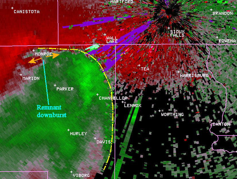
Fig. 4. Radar picture of velocity at noon CDT 18 August 2006. The outflow boundary has reached the Turner and Lincoln County border. There is evidence of a downburst east of Monroe, SD but it appears to be weakening.

Fig. 5. Radar velocity image from 12:04 pm CDT 18 August 2006. The outflow boundary (and associated storm) continue to move northeast. There is no evidence of a downburst at this time although the radar does show winds near 1000 ft around 30 mph in the vicinity of Chancellor, SD.

Fig. 6. Radar velocity image 12:08 pm CDT 18 August 2006. The outflow boundary has moved into western Lincoln County. Strong wind just behind the outflow boundary can be seen north of Chancellor, SD.

Fig. 7. Radar velocity image from 12:12 pm CDT 18 August 2006. A downburst can be seen south of Lennox, SD. Severe winds were not reported with this downburst. Notice that this downburst is occurring over 5 miles behind the outflow boundary. Therefore the strongest winds were not with the initial outflow boundary but occurred 5 to 10 minutes afterwards.
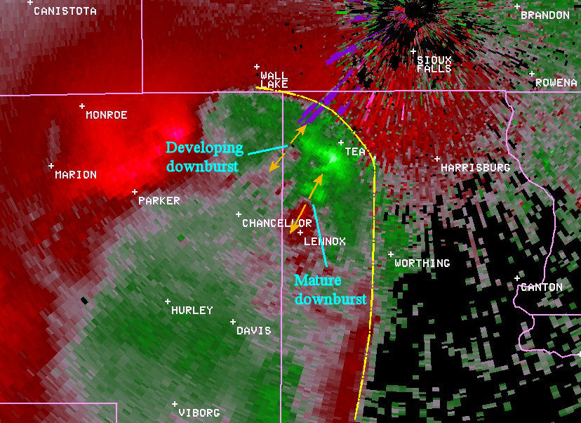
Fig. 8. Radar velocity image from 12:17 pm CDT 18 August 2006. A strong downburst can be observed north of Lennox, SD at this time. From the radar, it appears this downburst may have accelerated winds almost to the outflow boundary. Again, severe winds were not reported north of Lennox but some crop damage occurred. There is also evidence of a second downburst beginning to form west of Tea near the Turner County line.

Fig. 9. Radar velocity image from 12:22 pm CDT 18 August 2006. Two downbursts remain evident on radar. The first is located south of Tea, SD where crop damage was observed. The second is located near the Lincoln and Turner County line west of Tea, SD. Again the downbursts are approximately 5 miles behind the outflow boundary.
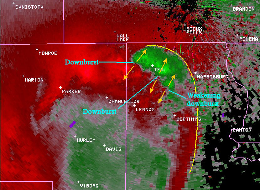
Fig. 10. Radar velocity from 12:27 pm CDT 18 August 2006. Three downbursts are seen on radar. The first is the weakening downburst south-southeast of Tea. A stronger downburst was located 2 miles south of Tea where power poles were snapped off 15 to 20 feet above the ground. The final downburst is located west-northwest of Tea where 2 foot diameter trees were blown down damaging a house and a garage door was ripped off a building tossing a person and breaking his arm.

Fig. 11. Radar velocity image from 12:32 pm CDT 18 August 2006. Two downbursts are evident on this picture. The first continues to move toward Tea, SD. The combined affects of this and previous downbursts have produce a large area of 40 to 60 mph in the vicinity of Tea resulting in widespread crop damage from a combination of wind and hail. The last downburst observed on radar is seen to be developing north of Worthing, SD.

Fig 12. Radar velocity image from 12:37 pm CDT 18 August 2006. The last downburst can be seen north of Worthing, SD. Strong winds produced crop damage east to Harrisburg, SD.


 Weather Story
 Weather Map
 Local Radar
 Follow us on YouTube