Significant severe weather occurred across much of the area during the later afternoon and evening hours of June 12, 2001. These storms initiated to the north of a warm frontal boundary which lifted into northeast Nebraska and northwest Iowa by late afternoon. Earlier in the day, storms initiated to the north of this front, lifting northeast and producing some dime to quarter size hail across northwest Iowa into southwest Minnesota.
A series of supercell thunderstorms erupted across the Tri-State area early in the evening, with at least two tracking directly across Sioux Falls with large hail, damaging winds, and a couple of brief tornado touchdowns. Hail up to baseball to softball size was reported on the southeastern side of Sioux Falls, causing significant damage to cars and rooves, with most areas of the city experiencing hail of quarter size or larger at least once during the evening. Figures 1a and 1b below show the two storms which moved across the Sioux Falls area.

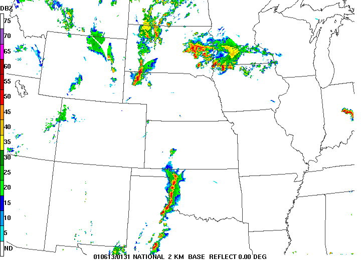
Figure 1. Regional radar image at 730 pm CDT 12 June 2001 (left) and 831 pm CDT 12 June 2001.
Signficant hail of quarter to golf ball size also tracked through much of the northwest Iowa north of highway 18, to areas just north of the Minnesota border. A third in the series of storms formed west of Sioux Falls after sunset, producing a small bow echo tracking eastward with reports of widespread wind damage from eastern South Dakota toward the Iowa Great Lakes.
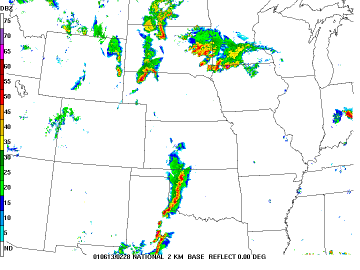
Figure 2. Regional radar image at 928 pm 12 June 2001.
In addition, a number of weak tornadoes were observed (shown in red in the images below), but produced minimal damage. Storm reports are plotted in the following image, with tabular data below.
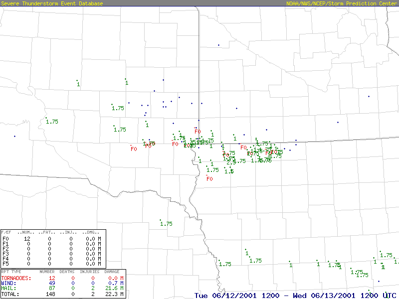
Figure 3. Storm Data reports from 7 am CDT Tuesday, June 12 to 7 am CDT Wednesday, June 13, 2001. Red represents tornadoes, blue (wind) and green (hail). Hail size is listed in inches. Image courtesy of the Storm Prediction Center, and can be produced for numerous events at www.spc.noaa.gov/climo/online/sp3/plot.php .
| Tornado Reports | ||||||||||||
| Time (UTC) | F Scale | Location | County | State | Lat | Lon | Comments | |||||
| 0012 | UNK | 2 W GARRETSON | MINNEHAHA | SD | 4371 | 9654 | REPORTED BY PUBLIC. (FSD) | |||||
| 0041 | UNK | SIOUX FALLS | MINNEHAHA | SD | 4371 | 9683 | REPORTED BY EMERGENCY MANAGEMENT. TREES DOWN AND VEHICLES DAMAGED. (FSD) | |||||
| 0226 | UNK | 1 S MONTGOMERY | DICKINSON | IA | 4341 | 9519 | (FSD) | |||||
| 0245 | UNK | OCHEYEDAN | OSCEOLA | IA | 4341 | 9555 | (FSD) | |||||
| 0246 | UNK | SPIRIT LAKE | DICKINSON | IA | 4343 | 9509 | ROPE TORNADO ON GROUND WITH DEBRIS. REPORTED BY MEDIA. (FSD) | |||||
| 0319 | UNK | 6 S HARTFORD | MINNEHAHA | SD | 4353 | 9694 | REPORTED BY EMERGENCY MANAGEMENT. (FSD) | |||||
| Hail Reports | ||||||||||||
| Time (UTC) | Size | Location | County | State | Lat | Lon | Comments | |||||
| 2117 | 100 | 1 NE HARRIS | OSCEOLA | IA | 4346 | 9543 | REPORTED BY STORM SPOTTER. (FSD) | |||||
| 2133 | 100 | RUSHMORE | NOBLES | MN | 4361 | 9580 | REPORTED BY LAW ENFORCEMENT OFFICIAL. (FSD) | |||||
| 2205 | 100 | 1 N LUVERNE | ROCK | MN | 4349 | 9625 | REPORTED BY LAW ENFORCEMENT OFFICIAL. (FSD) | |||||
| 2240 | 75 | 7 NW HARTLEY | OBRIEN | IA | 4310 | 9558 | REPORTED BY MEDIA. (FSD) | |||||
| 2250 | 100 | MAY CITY | OSCEOLA | IA | 4331 | 9548 | REPORTED BY MEDIA. (FSD) | |||||
| 2303 | 100 | INWOOD | LYON | IA | 4331 | 9644 | REPORTED BY STORM SPOTTER. (FSD) | |||||
| 2326 | 75 | 1 S BRANDON | MINNEHAHA | SD | 4356 | 9659 | REPORTED BY OFF-DUTY NWS EMPLOYEE. (FSD) | |||||
| 2327 | 88 | DELL RAPIDS | MINNEHAHA | SD | 4381 | 9671 | REPORTED BY EMERGENCY MANAGEMENT. (FSD) | |||||
| 2334 | 75 | COLTON | MINNEHAHA | SD | 4378 | 9693 | REPORTED BY EMERGENCY MANAGEMENT. (FSD) | |||||
| 2340 | 75 | 6 S TEA | LINCOLN | SD | 4334 | 9683 | REPORTED BY EMERGENCY MANAGEMENT. (FSD) | |||||
| 2341 | 75 | ROCK RAPIDS | LYON | IA | 4343 | 9618 | (FSD) | |||||
| 2345 | 88 | ROCK VLY | SIOUX | IA | 4319 | 9630 | (FSD) | |||||
| 2353 | 75 | 5 W ELLSWORTH | NOBLES | MN | 4351 | 9613 | (FSD) | |||||
| 2355 | 175 | 1 E HARTFORD | MINNEHAHA | SD | 4363 | 9692 | REPORTED BY EMERGENCY MANAGEMENT. (FSD) | |||||
| 0001 | 175 | SIOUX FALLS | MINNEHAHA | SD | 4371 | 9683 | REPORTED BY OFF-DUTY NWS EMPLOYEE. (FSD) | |||||
| 0015 | 175 | ROCK VLY | SIOUX | IA | 4319 | 9630 | REPORTED BY STORM SPOTTER. (FSD) | |||||
| 0024 | 175 | SIOUX FALLS | LINCOLN | SD | 4330 | 9681 | (FSD) | |||||
| 0025 | 275 | SIOUX FALLS | MINNEHAHA | SD | 4371 | 9683 | REPORTED BY PUBLIC. (FSD) | |||||
| 0033 | 175 | 1 S BRANDON | MINNEHAHA | SD | 4356 | 9659 | REPORTED BY OFF-DUTY NWS EMPLOYEE. (FSD) | |||||
| 0036 | 75 | ROCK RAPIDS | LYON | IA | 4343 | 9618 | (FSD) | |||||
| 0053 | 100 | SHELDON | SIOUX | IA | 4308 | 9620 | (FSD) | |||||
| 0100 | 175 | MAY CITY | OSCEOLA | IA | 4331 | 9548 | REPORTED BY STORM SPOTTER. (FSD) | |||||
| 0118 | 175 | 5 NE FORESTBURG | SANBORN | SD | 4407 | 9801 | REPORTED BY STORM SPOTTER. (FSD) | |||||
| 0119 | 75 | MILFORD | DICKINSON | IA | 4333 | 9514 | REPORTED BY MEDIA. (FSD) | |||||
| 0135 | 175 | BRIDGEWATER | MCCOOK | SD | 4354 | 9750 | REPORTED BY MEDIA. (FSD) | |||||
| 0145 | 275 | OCHEYEDAN | OSCEOLA | IA | 4341 | 9555 | REPORTED BY MEDIA. (FSD) | |||||
| 0155 | 75 | ROCK RAPIDS | LYON | IA | 4343 | 9618 | REPORTED BY STORM SPOTTER. (FSD) | |||||
| 0158 | 175 | 10 W MILFORD | DICKINSON | IA | 4333 | 9537 | REPORTED BY STORM SPOTTER. (FSD) | |||||
| 0220 | 175 | SPIRIT LAKE | DICKINSON | IA | 4343 | 9509 | REPORTED BY STORM SPOTTER. (FSD) | |||||
| 0220 | 100 | ELLSWORTH | NOBLES | MN | 4351 | 9601 | REPORTED BY STORM SPOTTER. (FSD) | |||||
| 0223 | 100 | 10 SW JACKSON | JACKSON | MN | 4349 | 9516 | REPORTED BY STORM SPOTTER. (FSD) | |||||
| 0238 | 88 | 7 S MELVIN | OSCEOLA | IA | 4316 | 9561 | REPORTED BY STORM SPOTTER. (FSD) | |||||
| 0246 | 175 | SPIRIT LAKE | DICKINSON | IA | 4343 | 9509 | REPORTED BY MEDIA. (FSD) | |||||
| 0250 | 100 | IROQUOIS | KINGSBURY | SD | 4445 | 9748 | (FSD) | |||||
| 0315 | 88 | HARTFORD | MINNEHAHA | SD | 4363 | 9694 | REPORTED BY EMERGENCY MANAGEMENT. (FSD) | |||||
| 0456 | 75 | MADISON | LAKE | SD | 4400 | 9711 | REPORTED BY LAW ENFORCEMENT OFFICIAL. (FSD) | |||||
| 0520 | 75 | FLANDREAU | MOODY | SD | 4404 | 9658 | REPORTED BY PUBLIC. (FSD) | |||||
| 0539 | 88 | CROOKS | MINNEHAHA | SD | 4366 | 9681 | (FSD) | |||||
| 0627 | 75 | 6 SW CHANDLER | MURRAY | MN | 4386 | 9604 | (FSD) | |||||
| 0628 | 75 | CHAMBERLAIN | BRULE | SD | 4379 | 9933 | REPORTED BY LAW ENFORCEMENT OFFICIAL. (FSD) | |||||
| 0714 | 175 | CHAMBERLAIN | BRULE | SD | 4379 | 9933 | REPORTED BY LAW ENFORCEMENT OFFICIAL. (FSD) | |||||
| 1145 | 88 | 6 E HOWARD | MINER | SD | 4401 | 9739 | (FSD) | |||||
| 1153 | 75 | 2 SE WINFRED | LAKE | SD | 4397 | 9733 | REPORTED BY PUBLIC. (FSD) | |||||
| Wind Reports | ||||||||||||
| Time (UTC) | Speed | Location | County | State | Lat | Lon | Comments | |||||
| 0104 | 62 | SHELDON | SIOUX | IA | 4308 | 9620 | MEASURED BY AWOS AUTOMATIC OBSERVING EQUIPMENT. (FSD) | |||||
| 0158 | 60 | 10 W MILFORD | DICKINSON | IA | 4333 | 9537 | REPORTED BY STORM SPOTTER. (FSD) | |||||
| 0244 | 65 | 1 S VALLEY SPGS | MINNEHAHA | SD | 4356 | 9646 | REPORTED BY EMERGENCY MANAGEMENT. (FSD) | |||||
| 0356 | UNK | 2 W SIOUX FALLS | MINNEHAHA | SD | 4371 | 9683 | BARN DESTROYED. REPORTED BY EMERGENCY MANAGEMENT. (FSD) | |||||
| 0402 | 80 | SIOUX FALLS | MINNEHAHA | SD | 4371 | 9683 | REPORTED BY STORM SPOTTER. (FSD) | |||||
| 0456 | 60 | COLTON | MINNEHAHA | SD | 4378 | 9693 | REPORTED BY LAW ENFORCEMENT OFFICIAL. (FSD) | |||||
This was hardly a one day event, as on the following day (June 13), another significant severe weather outbreak occurred with large hail, several tornadoes, and a widespread damaging wind event across southwest Minnesota and northwest Iowa with measured winds of 65 to 90 mph.
Article originally posted on June 13, 2012


 Weather Story
 Weather Map
 Local Radar
 Follow us on YouTube