June 16, 1992 marks the day a devastating tornado ravaged portions of southwest Minnesota. Commonly referred as the Chandler-Lake Wilson tornado, this tornado destroyed more than 75 homes with another 90 homes, 10 businesses, a church and school damaged. The tornado caused over $50 million in property damage, resulting in more than 40 injuries and one fatality. Based on a detailed damage assessment by the National Weather Service, it is estimated this F5 tornado packed winds in excess of 260 mph as it tore through the residential area of Chandler Minnesota. This was the only F5 tornado to occur in the United States in 1992.

Figure 1. Picture of the Chandler-Lake Wilson Tornado, taken southeast of Leota, Minnesota. Picture courtesy of Gary Baker.
The Chandler-Lake Wilson tornado initially touched down shortly after 5pm in extreme northwest Nobles County, near Leota, Minnesota (Figure 1). The tornado completely destroyed a two house farmstead just east of Leota as it strengthened and churned its way northeast toward Chandler and Lake Wilson (Figure 2).
|
A |
B |
|
|
C |
D |
|
|
||
The "maxi-tornado" reached it's greatest size and strength as it came over the hill immediately south of Chandler, plowing into the residential area of west Chandler at approximately 5:18 pm. The giant twister was on the ground for over an hour, traveling approximately 35 miles across southwest Minnesota, from northwest Nobles County, through Murray County, and into southeast Lyon County. It had a maximum width of three-quarters of a mile in the Chandler-Lake Wilson area.

The approximate path of the Chandler-Lake Wilson tornado. The tornado rating is located next to the line.
The devastating Chandler-Lake Wilson tornado on June 16, 1992 was part of a major severe weather event to sweep across the Northern Plains that week. A major spring storm began developing in the western United States over the weekend of June 13-14, 1992. The storm ejected a minor upper air impulse across the Northern Plains on June 13 triggering severe weather across the extreme northwest corner of South Dakota. Golf ball sized hail and 10½ inches of rain destroyed crops and killed over 500 sheep in Harding County, South Dakota. This event was a forewarning of the strength of the main storm which still lurked over the western United States.
On Tuesday, June 16, 1992, residents of eastern South Dakota and southwest Minnesota experienced the full fury of the storm as it moved from the Rocky Mountain Region across the Upper Midwest. At least two dozen tornadoes were reported that day, with more than three times that many reports of large hail and strong winds, causing widespread swaths of damage to crops, buildings, and other personal property across much of eastern South Dakota and southwest Minnesota. The first tornado, spawned by thunderstorms known as "supercell thunderstorms", touched down in Charles Mix county of south central South Dakota around 1pm. The last tornado was reported shortly before midnight that evening, ending an 11 hour period of intense and life-threatening severe weather across eastern South Dakota and southwest Minnesota.
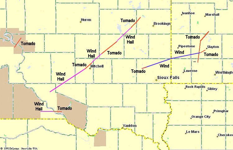
Map showing the path of the most significant storms that occurred on 16 June 1992. A magenta line signifies wind and hail damage, a blue line signifies wind damage, and a red line signifies tornado damage.
In addition to the severe weather, another devastating weather event was taking place across northeastern South Dakota. Heavy rains were occurring in an area already saturated by previous rain. Over a two to three day period in mid June 1992, 15 to 20 inches of rain fell in the Clear Lake-Watertown area of northeast South Dakota, resulting in widespread flooding throughout the area, and major downstream flooding of the Big Sioux River.
The massive storm system finally weakened and moved far enough east on June 18, 1992 to end the severe weather and rain across South Dakota and southwest Minnesota.
On the 10th anniversary in 2002, the Chandler community leaders dedicated a tornado memorial near the old, damaged water tower. The family of the farmstead just east of Leota also commemorated the day with a family gathering at their rebuilt homestead location. Photos reflecting the rebuilding and perseverance of the Chandler community 10 years after the storm can be viewed below.
| 1992 | 2002 |
|---|---|
|
Central Chandler business district destroyed by the tornado. |
Central Chandler grain processing plant 10 years later. |
|
Picture of the destruction on the west side of Chandler. |
Picture of the west side of Chandler 10 years later. |
|
Picture of the destruction on the west side of Chandler. |
Picture of the west side of Chandler 10 years later. |
|
Picture of the Don and Debbie Buys residence after the tornado moved through Chandler. Taken 17 June 1992. |
Picture of the Buys residence - the first house rebuilt in Chandler after the tornado. Taken 12 June 2002. |
|
Picture of the street sign at 4th and Carlton. |
Picture of the street sign at 4th and Carlton 10 years later. |
|
A house totally destroyed. Three people in this house and no injuries. |
House rebuilt on the same hill. Taken 12 June 2002. |
|
The damaged water tower. Picture taken 12 June 2002. |
The new Chandler water tower. Taken 12 June 2002. |
Note: This story was written on the 10th Anniversary of the Chandler-Lake Wilson Minnesota Tornado and has been modified since then.


 Weather Story
 Weather Map
 Local Radar