Overview
For current river observations, forecasts, and warnings, please visit www.weather.gov/desmoines/water
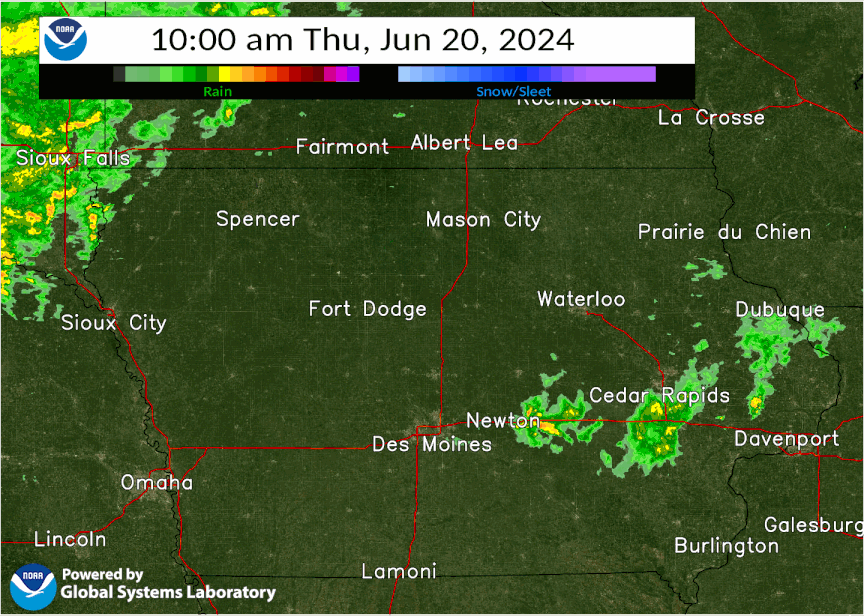
Heavy rain fell over portions of northern Iowa, especially northwestern Iowa up into portions of southwest Minnesota and southeastern South Dakota later on June 20 through early on June 21. This rainfall caused flash flooding in portions of northwest Iowa and also aided in saturating the soil. As another round of heavy rain fell later on June 21 into the night and morning of June 22, this rainfall led to renewed flash flooding. This rainfall made its way into streams and rivers resulting in significant and record river flooding in northwest Iowa including the West Fork of the Des Moines River. This page will continue to be populated with information and updated in the coming weeks. Information is preliminary and subject to change! Summaries from other NWS Offices: Sioux Falls, SD | Twin Cities, MN
Page last updated: July 12, 2024 10 PM
|
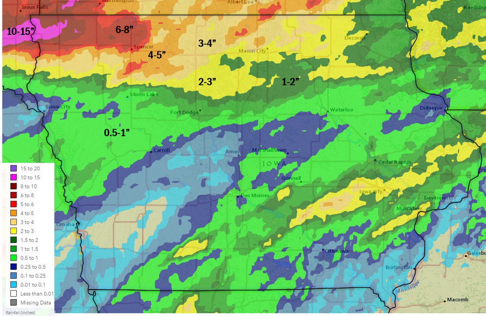 June 20-22, 2024 3 day Multi-sensor Estimated Rainfall |
 |
 |
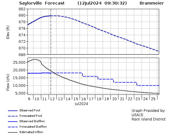 |
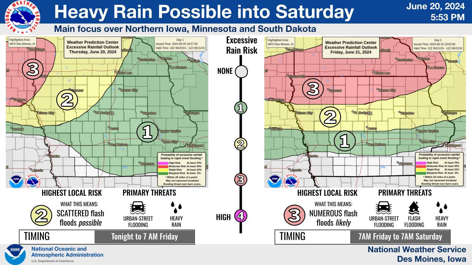
| Heavy rain messaging from the early evening of 6-20-24. | Radar capture at 12:15 AM 6.22.24 with ongoing Flash Flood Warnings over portions of northern Iowa into southern Minnesota. | Saylorville forecast from the U.S. Army Corps of Engineers showing the lake pool elevation for Saylorville Lake cresting around 880 feet. Graphic as of July 12, 2024, courtesy of the USACE Rock Island District. |
Flooding
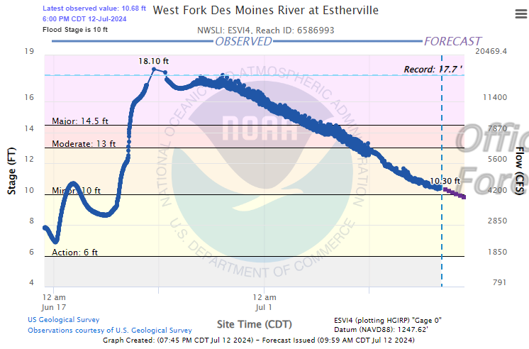
Moderate to major river flooding was widespread as a result of the heavy rainfall with multiple locations reaching record high river stages. Unfortunately, sporadic data outages at some gages led to incomplete hydrograph traces. We are working with local officials to determine the peak crest at these locations.
 |
|
New River Flood Records *All data preliminary and subject to change. Estherville record stage is estimated. |
Hydrographs
 |
 |
 |
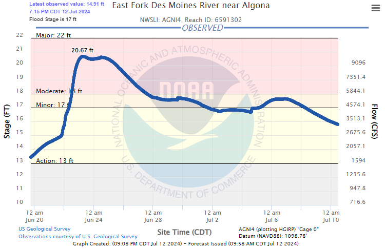 |
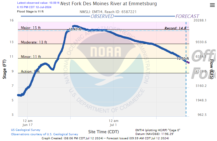
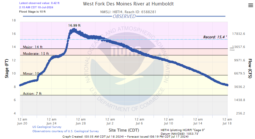
| West Fork Des Moines River at Estherville (ESVI4). New record crest on 6-24-24 estimated to be 17.94 ft from high water mark. | West Fork Des Moines River at Emmetsburg (EMTI4). New record crest on 6-24-24 observed to be 15.47 ft. | West Fork Des Moines River at Humboldt (HBTI4). New record crest on 6-27-24 observed to be 16.99 ft. | East Fork Des Moines River near Algona (AGNI4). Crest on 6-23-24 observed to be 20.67 ft, which ranks 3rd in historic crests for the site. |
 |
 |
||
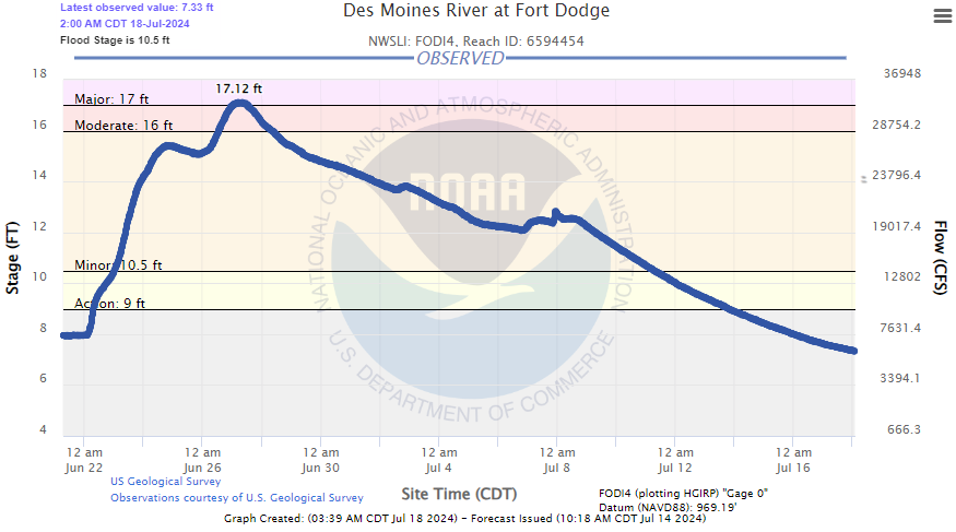
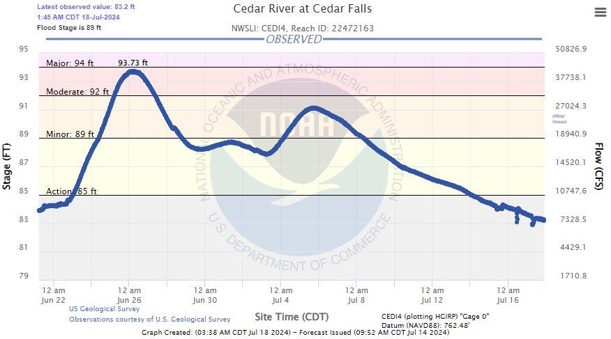
| Des Moines River at Fort Dodge (FODI4). Preliminary crest on 6-27-24 of 17.12 ft. | Cedar River at Cedar Falls (CEDI4). Preliminary crest on 6-26-24 of 93.73 ft. | Caption | Caption |
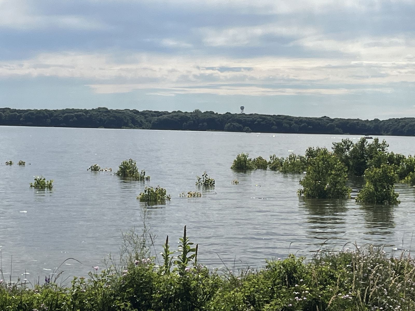
Photos & Video
Header
 |
|||
| View of NWS Des Moines Radar from east side of Saylorville Lake overlooking flooded beach and lower parking area at Cherry Glen. (source: NWS Des Moines Staff) |
Caption (source) |
Caption (source) |
Caption (source) |
Radar
Header
 |
.gif) |
| Radar Loop from June 20, 2024 10am to June 23, 2024 at 10am | Same as left, but faster loop |
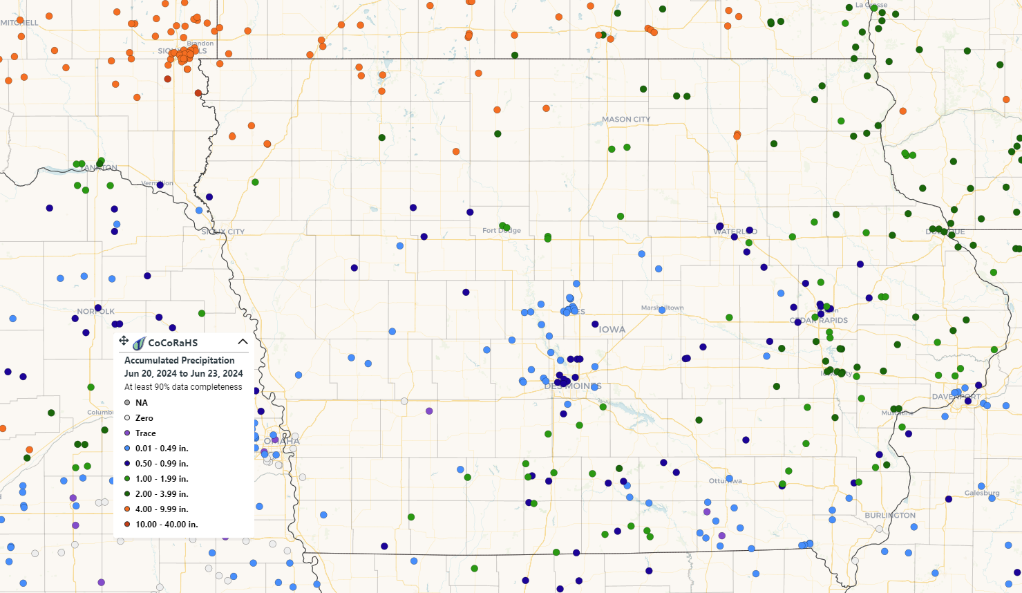
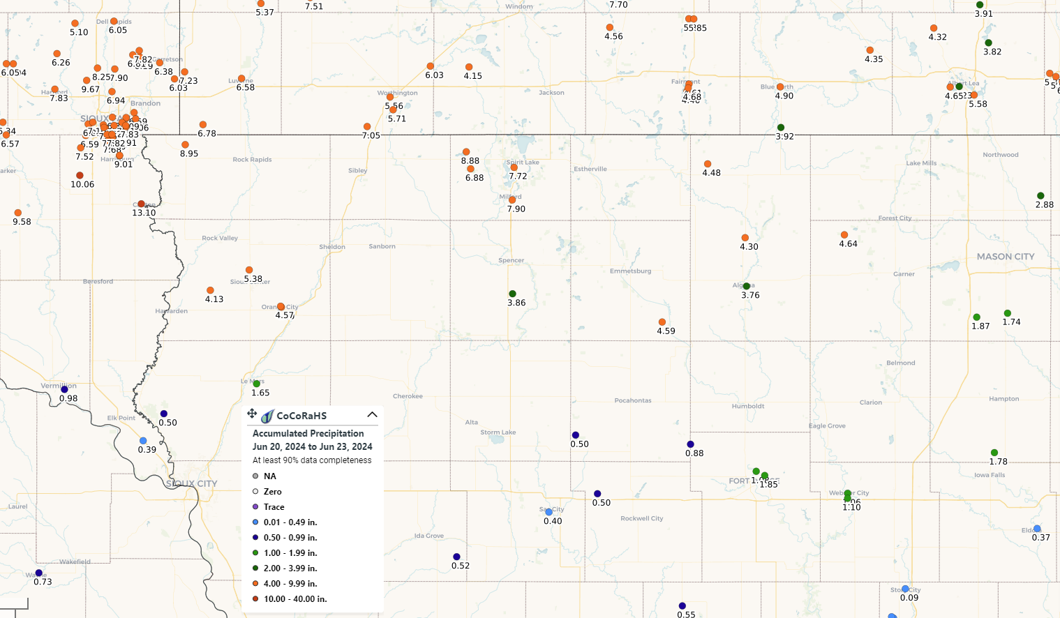
Rain Reports
 |
 |
|
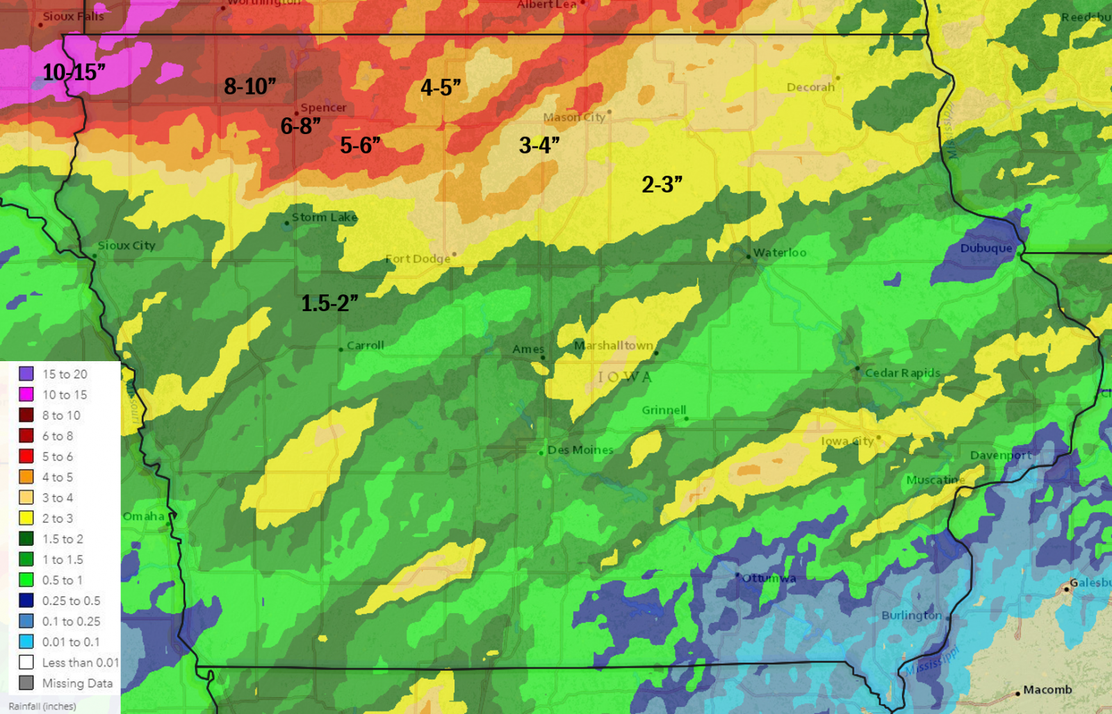 |
| CoCoRaHS rainfall reports June 20-23, 2024 | CoCoRaHS rainfall reports June 20-23, 2024 zoomed in over northwestern Iowa | June 20-22, 2024 3 day Multi-sensor Estimated Rainfall | June 18-22, 2024 5 day Multi-sensor Estimated Rainfall |
Preliminary Local Storm Report
National Weather Service Des Moines IA

..TIME...   ...EVENT...      ...CITY LOCATION...     ...LAT.LON...
..DATE...   ....MAG....      ..COUNTY LOCATION..ST.. ...SOURCE....
            ..REMARKS..
0100 AM Rain Mallard 42.94N 94.68W
06/22/2024 M3.47 Inch Palo Alto IA Mesonet
Mesonet station EW0956 Mallard.
0109 AM Rain 2 WNW Gruver 43.40N 94.75W
06/22/2024 M3.02 Inch Emmet IA ASOS
ASOS station KEST Estherville Airport.
0110 AM Rain 5 SE Hanlontown 43.23N 93.31W
06/22/2024 M3.28 Inch Cerro Gordo IA Mesonet
Mesonet station GW0743 Mason City.
0400 AM Rain 4 ESE Lake Cornelia 42.76N 93.62W
06/22/2024 M2.02 Inch Wright IA CO-OP Observer
CO-OP Observer station ROWI4 4.7 N Galt.
0408 AM Rain 2 WNW Gruver 43.40N 94.75W
06/22/2024 M2.67 Inch Emmet IA ASOS
ASOS station KEST Estherville Airport.
0600 AM Rain 2 WSW Goldfield 42.72N 93.95W
06/22/2024 M3.01 Inch Wright IA Mesonet
Mesonet station GLDI4 1.5 SW Goldfield.
0600 AM Rain 1 NW Burt 43.21N 94.23W
06/22/2024 M3.30 Inch Kossuth IA Cocorahs
Cocorahs station IA-KS-5 Burt 0.5 NW. 3.30 inches.
0630 AM Rain Mallard 42.94N 94.68W
06/22/2024 M3.78 Inch Palo Alto IA Mesonet
Mesonet station EW0956 Mallard.
0630 AM Rain 2 WSW Crystal Lake 43.21N 93.84W
06/22/2024 M4.26 Inch Hancock IA Cocorahs
Cocorahs station IA-HN-8 Britt 8.2 NNW. 4.26 inches.
0635 AM Rain Grafton 43.33N 93.08W
06/22/2024 M2.68 Inch Worth IA Mesonet
Mesonet station EW5720 Grafton.
0658 AM Rain Buffalo Center 43.39N 93.94W
06/22/2024 M4.00 Inch Winnebago IA Public
Report from social media.
0700 AM Rain 2 NE Bode 42.89N 94.26W
06/22/2024 M3.30 Inch Humboldt IA Cocorahs
Cocorahs station IA-HB-4 Bode 1.9 NE. 3.30 inches.
0700 AM Rain 5 SSW Rodman 42.96N 94.55W
06/22/2024 M4.41 Inch Palo Alto IA Cocorahs
Cocorahs station IA-PA-5 West Bend 5.4 W. 4.41 inches.
0700 AM Rain 1 SE Algona 43.07N 94.22W
06/22/2024 M3.71 Inch Kossuth IA Cocorahs
Cocorahs station IA-KS-4 Algona 0.7 SE. 3.71 inches.
0700 AM Rain 1 SE Algona 43.07N 94.22W
06/22/2024 M3.71 Inch Kossuth IA Mesonet
Mesonet station ALGI4 Algona. 3.71 inches.
0700 AM Rain 2 WSW Goldfield 42.72N 93.95W
06/22/2024 M3.01 Inch Wright IA Mesonet
Mesonet station GLDI4 1.5 SW Goldfield. 3.01 inches.
0733 AM Rain 5 SSE Dumont 42.69N 92.92W
06/22/2024 M4.50 Inch Butler IA Trained Spotter
Rainfall report ending at 7:30 am from
yesterday evenings and this mornings
rainfall.
0823 AM Rain 2 NNW Fort Dodge 42.53N 94.18W
06/22/2024 M3.06 Inch Webster IA Mesonet
Mesonet station GW4516 FORT DODGE. 3.06 inches.
0825 AM Rain 2 WNW Gruver 43.40N 94.75W
06/22/2024 M3.16 Inch Emmet IA ASOS
ASOS station KEST Estherville Airport. 3.16 inches.
0830 AM Rain 2 S Algona 43.04N 94.23W
06/22/2024 M4.00 Inch Kossuth IA Public
Public relayed, via social media, 4 inches
of rainfall from yesterday evening and
overnight.
0830 AM Rain 5 SE Hanlontown 43.23N 93.31W
06/22/2024 M4.26 Inch Cerro Gordo IA Mesonet
Mesonet station GW0743 Mason City. 4.26 inches.
0830 AM Rain 1 NNW Algona 43.08N 94.24W
06/22/2024 M3.14 Inch Kossuth IA Mesonet
Mesonet station 3044D Algona. 3.14 inches.
0830 AM Rain 1 ENE West Bend 42.96N 94.45W
06/22/2024 M7.50 Inch Palo Alto IA Public
This is from Friday 6 am through 830am this
morning. Public, via social media, relayed
7.5 inches rainfall.
0845 AM Rain 1 NW Britt 43.11N 93.82W
06/22/2024 M4.50 Inch Hancock IA Public
Public, via social media, relayed 4.50
inches of rain from yesterday evening and
overnight.
0850 AM Rain 4 W Manly 43.29N 93.28W
06/22/2024 M3.18 Inch Worth IA Public
Public, via social media, relayed rainfall
amount of 3.18 inches from evening and
overnight.
0850 AM Rain 1 S Thompson 43.36N 93.77W
06/22/2024 M5.10 Inch Winnebago IA Public
Public, via social media, relayed 5.10
inches of rain from yesterday evening and
overnight.
0850 AM Rain Clear Lake 43.14N 93.37W
06/22/2024 M5.00 Inch Cerro Gordo IA Public
Public, via social media, relayed 5 inches
of rain from yesterday evening and
overnight.
0900 AM Rain Lake Mills 43.42N 93.53W
06/22/2024 M4.50 Inch Winnebago IA Public
Public, via social media, relayed 4.5 inches
rainfall from yesterday evening and
overnight.
0900 AM     Rain             2 W Denver              42.67N 92.36W

06/22/2024  M5.00 Inch       Bremer             IA   Public


            Public, via social media, relayed 5 inches

            rainfall from yesterday evening and

            overnight.
0914 AM Rain Bancroft 43.29N 94.22W
06/22/2024 M5.25 Inch Kossuth IA Public
Public, via social media, relayed 5.25
inches of rain from yesterday evening and
overnight.
1000 AM Rain Buffalo Center 43.39N 93.94W
06/22/2024 M4.00 Inch Winnebago IA Public
Public, via social media, relayed 4 inches
rainfall from yesterday evening and
overnight.
Environment
Insert synoptic summary.
| Figure 1: Caption | Figure 2: Caption | Figure 3: Caption |
Near-storm environment summary.
| Figure 4: Caption | Figure 5: Caption | Figure 6: Caption |
Additional environmental data.
| Figure 7: Caption | Figure 8: Caption | Figure 9: Caption |
Additional Information
The Forecast
| SPC Day 3 Categorical Outlook | SPC Day 3 Probabilistic Outlook | SPC Day 2 Categorical Outlook | SPC Day 2 Probabilistic Outlook |
| SPC Day 1 Categorical Outlook | SPC Day 1 Tornado Outlook | SPC Day 1 Hail Outlook | SPC Day 1 Wind Outlook |
 |
Media use of NWS Web News Stories is encouraged! Please acknowledge the NWS as the source of any news information accessed from this site. |
|

