Here is the latest Area Forecast Discussion for Central PA
This text statement is the latest forecast reasoning from the NWS in State College, PA
See the links at the bottom of the page for previous issuances/versions of the statement as well as our other text statements.
000 FXUS61 KCTP 180545 AFDCTP Area Forecast Discussion National Weather Service State College PA 145 AM EDT Sat May 18 2024 .SYNOPSIS... A decaying frontal system will keep showers over mainly western and central portions of central Pennsylvania overnight. Low pressure passing well to the south of Pennsylvania will bring additional showers to central Pennsylvania into Saturday afternoon, followed by high pressure and dry weather arriving for Sunday. Mainly dry conditions are expected through the middle of next week. && .NEAR TERM /THROUGH TODAY/... Decaying frontal system and upper level shear axis sagging into western and central PA this evening has maintained scattered to numerous showers through late evening. Leading edge of shower activity has been very slow to progress eastward tonight, but a weak 850 mb jet and persistent WSW flow aloft associated with 5H shear axis moving into western PA is finally nudging the showers farther east late this evening. Far eastern/southeastern areas may not see showers arrive until a few hours before sunrise, and even then they will be quite light. Aforementioned shear axis will continue to maintain sct to numerous showers overnight, with moist southeast upslope flow enhancing showers in favored terrain while also supporting low clouds/cigs and fog. Should breaks develop over my northwest counties, dense fog could develop overnight, but confidence at this time is low for the NE Ohio cloud breaks to overspread the NW Mountains through midnight. More likely that fog thickens in the predawn hours and midnight shift will need to consider fog headlines overnight. Lows in the 55-60F range are +5-15F above mid May climo with the larger departures across the western and northern Alleghenies. && .SHORT TERM /TONIGHT THROUGH MONDAY/... No changes seen for Saturday as we`ll have yet another weekend day to start the weekend. The morning and afternoon will feature plenty of clouds, periods of light rain/showers, and areas of fog. Hires model data focuses the bulk of the rain early in the day, becoming more scattered through the afternoon into the evening. Cool air damming (CAD) pattern with moist east southeast flow will result in highs of 60-65F across the southeast half of the CWA (5-10F below climo), and warmer readings over the NW mountains aided by downsloping with 70-75F expected there. Continued to temper NBM with blend of raw hires model data given typical downside risk for cooler temps in this type of CAD pattern setup. Sunday is looking increasingly nice with high pressure eventually allowing a good deal of sunshine throughout and salvaging the second half of the weekend. Decreasing deep layer moisture and a northerly wind component along with ridging at the sfc and aloft should help highs recover nicely with temps around 80F fcst in the NW Alleghenies and mid to upper 60s elsewhere. We are likely to see some areas of fog both Saturday night and Sunday night, and temps will continue to trend warmer with dry weather persisting into early next week with highs on Monday reaching the upper 70s to mid 80s. && .LONG TERM /MONDAY NIGHT THROUGH FRIDAY/... A dry start to the extended period will be likely with high pressure ridging building over the mid-atlantic region and a deep surface low parked over the central plains. High pressure and dry air will stay in place through Tuesday before the upper level trough pushes them both out by Wednesday afternoon. 850mb temps of near 16C along with surface warm air advection suggest high temperatures could reach the mid 80s on Tuesday and Wednesday. By the middle of next week, upper troughing will move across Pennsylvania and support a better chance for showers and thunderstorms. At the surface, there remains plenty of model uncertainty about the timing of a cold front. The mean timing is Wednesday afternoon, but individual models bring precipitation as early as Tuesday evening and as a late as Thursday morning. If the front moves through Wednesday afternoon or evening, it could produce the first threat for severe weather in some time given the aforementioned WAA bringing greater instability. After the front moves through, considerable uncertainty exists in terms of how much and how frequent rain will be. A chance of showers remains in place through the end of the week despite zonal flow aloft providing little in the way of synoptic forcing. The next chance for a widespread soaking rain will come during the weekend with a center of low pressure developing across the Ohio Valley by Friday afternoon. && .AVIATION /06Z SATURDAY THROUGH WEDNESDAY/... IFR cigs are likely (> 80% confidence) over the western highlands (BFD, JST) overnight, with borderline IFR/MVFR cigs expected over the central mtns (AOO, UNV). Farther to the east, the Susq Valley should eventually see cigs drop to MVFR during the pre-dawn hours. IFR (or borderline IFR/MVFR) cigs will be dominant areawide through the morning hours, along with periods of light rain. Patchy light rain will persist into the afternoon to the southeast of the Allegheny Front, along with low-end MVFR cigs. For the western highlands, cigs should improve to MVFR (perhaps even low-end VFR) this afternoon although scattered rain showers are possible. Outlook... Sun...Morning low cigs/fog possible. Becoming VFR by afternoon. Mon...Patchy AM fog possible. Otherwise, becoming VFR. Tue...Predominantly VFR, w/ no sig wx expected. Wed...Sct to widespread SHRA/TSRA return. && .CTP WATCHES/WARNINGS/ADVISORIES... None. && $$ SYNOPSIS...DeVoir/Steinbugl NEAR TERM...DeVoir/Steinbugl SHORT TERM...DeVoir/Steinbugl LONG TERM...DeVoir/Bowen AVIATION...Evanego |
|
Forecaster's |
County-by-County |
Daily Co-operative Station |
Public Information |
|
All NWS State College Text Statements/Forecasts:
|
|||
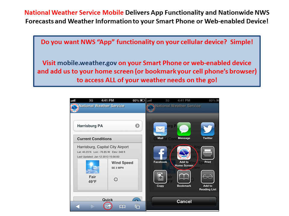
CLICK ON THE IMAGE BELOW TO USE THE NWS MOBILE WEB APP
|


 Send Us a Report