
A cold front lingering over Florida will continue to bring showers and thunderstorms to the state and a flash flooding threat to the east coast over the next couple of days. Fire weather concerns are expected in portions of the Florida panhandle into southeastern Georgia. A Kona Low is expected to bring strong winds, widespread heavy rainfall, and flooding concerns to Hawaii through the weekend. Read More >
New York CWSU
Center Weather Service Unit

 |
||
|
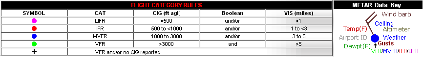
Click here for the latest regional surface plot.
|
 SIGMETS: ICE | TURB | IFR | CONV | ALL |
|
|---|


