Social Media: Science #NWSCitizenScience #CitizenScience
Please help the NWS spread these messages on social media! Everyone is welcome to use the text and images provided below to help the NWS build a Weather-Ready Nation.
Facebook
Have you ever wondered how tornadoes are officially confirmed? Meteorologists at National Weather Service forecast offices apply a careful, thorough process with roughly 4 steps.
X
Have you ever wondered how tornadoes are officially confirmed? Meteorologists at National Weather Service forecast offices apply a careful, thorough process with roughly 4 steps.
How are tornadoes officially confirmed? National Weather Service (NWS) meteorologists at local Forecast Offices apply a careful, thorough process to verify that a tornado actually occurred. Step 1: Gather Information. NWS meteorologists gather damage info from emergency managers, storm spotters, and the public. If you have any pictures or videos, please share them with us. Step 2: Plan Storm Survey. Using the information gathered, NWS meteorologists decide which locations to send storm survey teams. The number of teams depends on the extent of damage reports - usually no more than three teams per day. Step 3. Conduct Storm Survey. NWS meteorologists travel to impacted areas to assess damage. Preliminary conclusions can be made about the type and severity of storms using damage indicators. Step 4: Report Conclusions. Once back at the office, NWS meteorologists will assess the data, consult experts, then write summaries and reports of findings. This process can take hours or days.
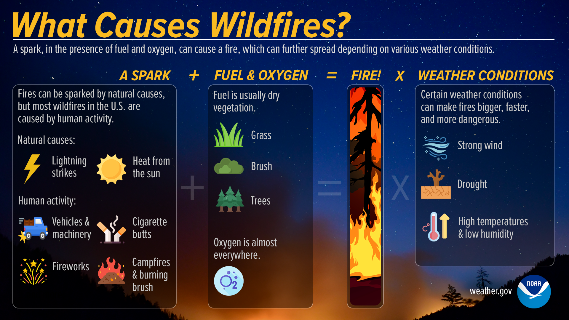
What Causes Wildfires?
Facebook
Wildfires are caused by a spark (usually man-made) in the presence of fuel (dry vegetation) and oxygen. Strong winds, high temperatures, low humidity and drought conditions can further impact the fire’s spread. To stay Weather-Ready and protect yourself from wildfires, visit weather.gov/safety/wildfire
X
Wildfires are caused by a spark in the presence of fuel and oxygen. Strong winds, high temperatures, low humidity and drought conditions can further impact the fire’s spread. To stay #WeatherReady and protect yourself from wildfires, visit weather.gov/safety/wildfire
What causes wildfires? A spark, in the presence of fuel and oxygen, can cause a fire, which can further spread depending on various weather conditions. Fires can be sparked by natural causes, but most wildfires in the U.S. are caused by human activity. Natural causes include lightning strikes and heat from the sun. Human activity comes from cigarette butts, fireworks, campfires, burning brush, vehicles and machinery. Fuel is usually dry vegetation, such as grass brush, and trees. Oxygen is almost everywhere. Certain weather conditions can make fires bigger, faster, and more dangerous: strong wind, drought, high temperatures and low humidity.
Tsunami Detection & Forecasting Explained
Facebook
Tsunami Warning Center scientists use a variety of tools to detect, measure, and forecast tsunamis. Learn more: weather.gov/jetstream/tsu_detect
X
Tsunami Warning Center scientists use a variety of tools to detect, measure, and forecast tsunamis. Learn more: weather.gov/jetstream/tsu_detect
Tsunami Detection and Forecasting Explained. Seismic stations detect and measure earthquakes, which cause most tsunamis. Seismic waves travel 100x faster than tsunamis, so this is the first available data for quake-generated events. Water-level networks detect and measure the actual tsunamis. DART systems measure water changes at the bottom of the sea. Tidal stations near the coast measure ocean height. If a tsunami is detected, Tsunami Warning Center scientists run forecast models using real-time water and seismic data, preset scenarios, and bathymetry and topography. Forecsts show the path of tsunami waves across the ocean and estimate impacts at specific coastal locations, including wave heights, arrival times, locations and extent of flooding, and how long the waves will last.
Science of Tornadoes (Video)
Facebook
Of all the many dangerous weather hazards, tornadoes are one of the most powerful and destructive. Although the details of their formation are still being researched, we do know the general steps. Watch this video for a quick science lesson. youtu.be/MMLRNW4UJOc
X
Although the details of tornado formation are still being researched, we do know the general steps. Watch this video for a quick #science lesson. youtu.be/MMLRNW4UJOc
Science of Lightning (Video)
Facebook
You already know to take shelter as soon as you hear thunder or see lightning. But have you ever wondered why lightning and thunder happen in the first place? Watch this video for a quick science lesson. youtu.be/Zd-Lc1cZDtA
X
You already know to take shelter as soon as you hear thunder or see lightning. But have you ever wondered why lightning and thunder happen in the first place? Watch this video for a quick #science lesson. youtu.be/Zd-Lc1cZDtA
Science of Hail (Video)
Facebook
Chunks of ice that fall from the sky can cause serious damage to people, animals, and property. But what exactly causes hail to form? Watch this video for some hail science! youtu.be/w1g0TToHTIA
X
Chunks of ice that fall from the sky can cause serious damage to people, animals, and property. But what exactly causes hail to form? Watch this video for some hail #science! youtu.be/w1g0TToHTIA
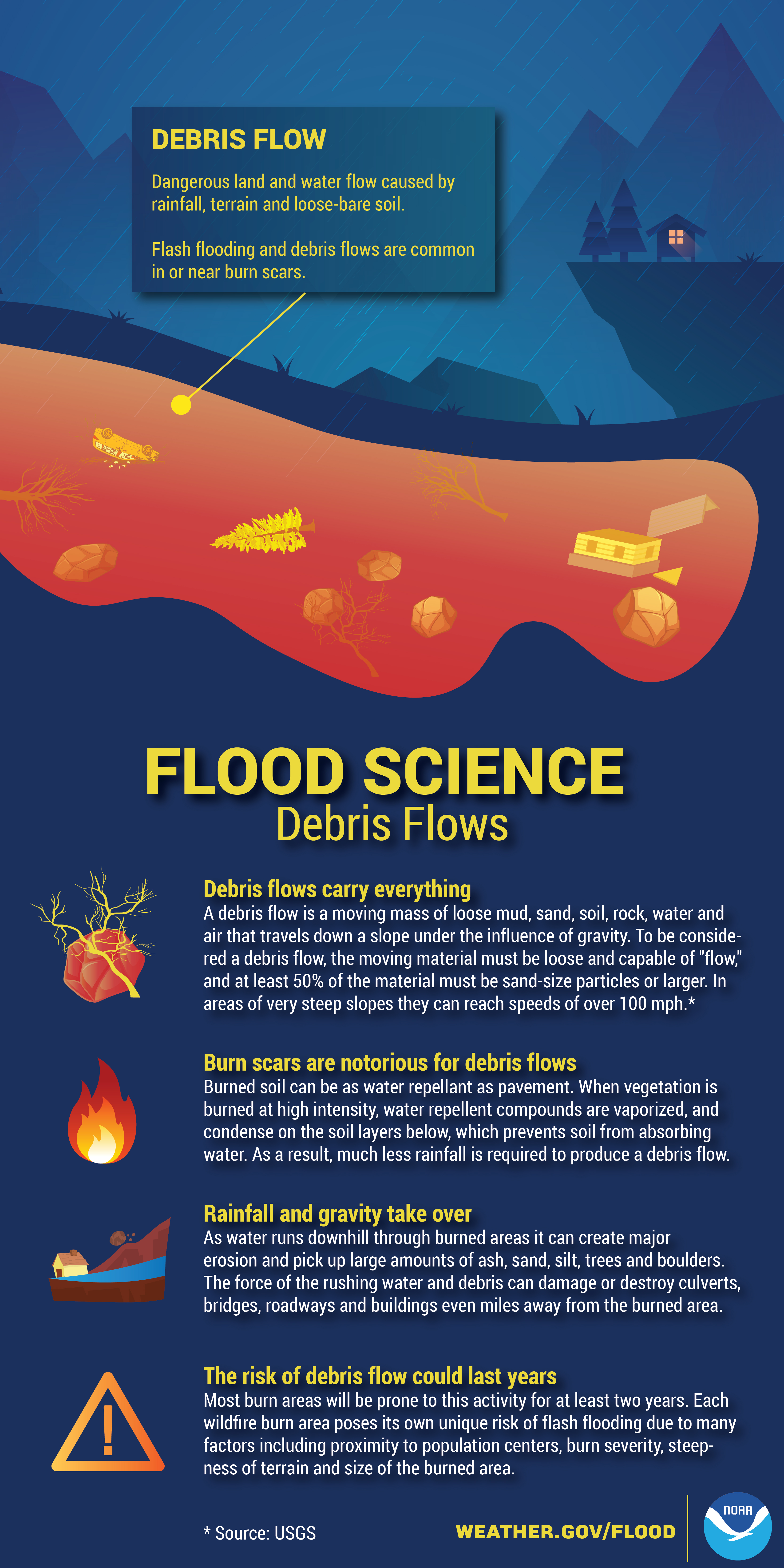
Science of Debris Flow
Facebook
Water is essential for life on Earth. However, in large enough quantities, the very substance we drink and use to grow crops can destroy homes and businesses, and can also cause fatalities. Learn all about the science of river flooding in the infographic below, and visit weather.gov/jetstream/flood for more flood science.
X
Learn all about the science of river flooding with this graphic, and visit weather.gov/jetstream/flood for more flood science. #WeatherReady
Flood Science - Debris Flows Debris Flows: Dangerous land and water flow caused by rainfall, terrain and loose-bare soil. Flash flooding and debris flows are common in or near burn scars. Debris flows carry everything: A debris flow is a moving mass of loose mud, sand, soil, rock, water and air that travels down a slope under the influence of gravity. To be considered a debris flow, the moving material must be loose and capable of 'flow', and at least 50% of the material must be sand-size particles or larger. In areas of very steep slopes they can reach speeds of over 100 mph. Burn scars are notorious for debris flows: Burned soil can be as water repellant as pavement. When vegetation is burned at high intensity, water repellent compounds are vaporized, and condense on the soil layers below, which prevents soil from absorbing water. As a result, much less rainfall is required to produce a flash flood. Rainfall and gravity take over: As water runs downhill through burned areas it can create major erosion and pick up large amounts of ash, sand, silt, trees and boulders. The force of the rushing water and debris can damage or destroy culverts, bridges, roadways, and buildings even miles away from the burned area. The risk of debris flow could last years: Most burn areas will be prone to this activity for at least two years. Each wildfire burn area poses its own unique risk of flash flooding due to many factors including proximity to population centers, burn severity, steepness of terrain, and size of the burned area. www.weather.gov/flood
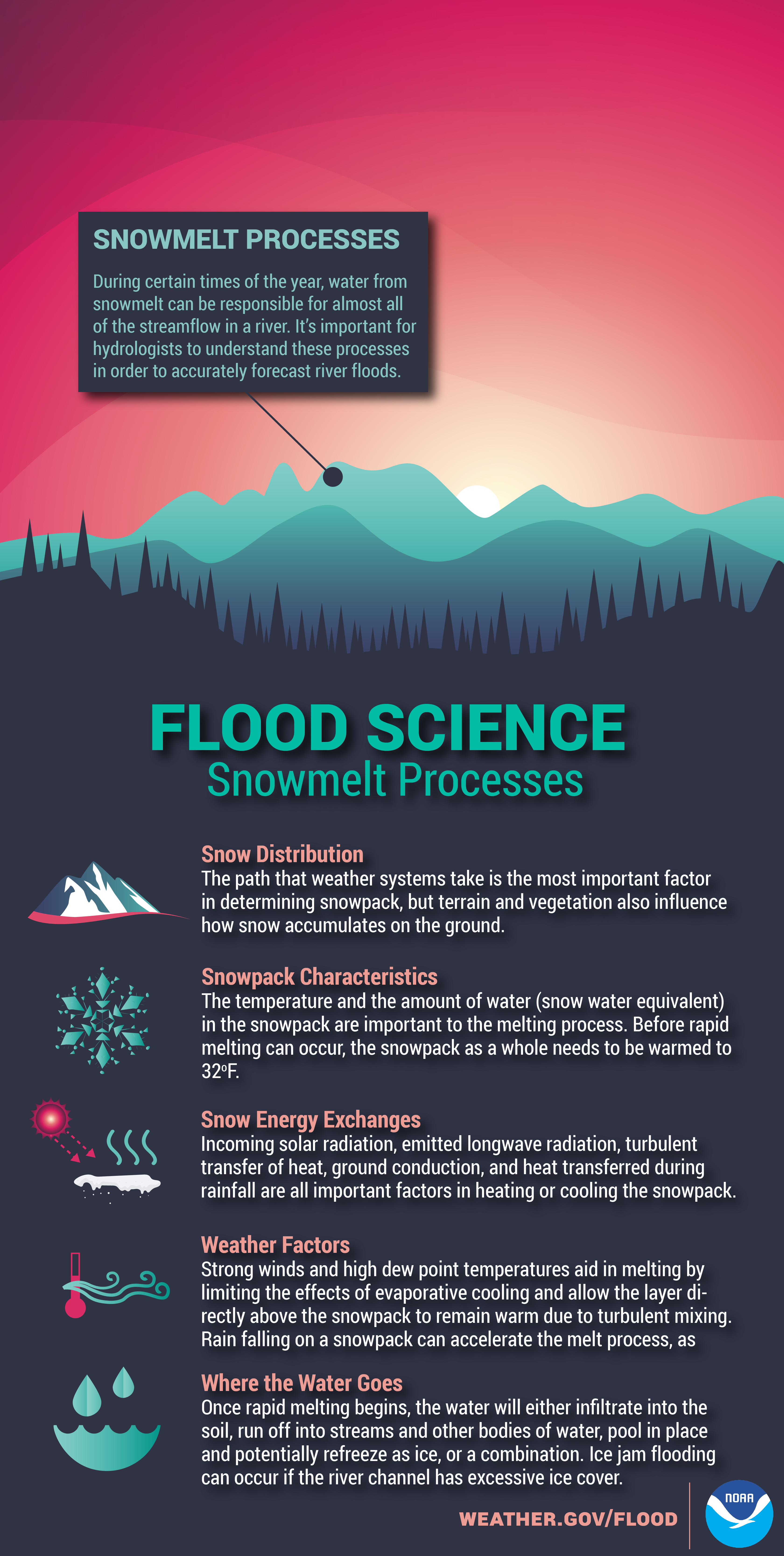
Science of Snowmelt Processes
Facebook
At certain times of the year, water from melting snow can be responsible for almost all of the streamflow in a river. The processes of snowmelt are crucial in forming accurate river flood forecasts. Learn more about flood science at weather.gov/jetstream/flood.
X
At certain times of the year, water from melting snow can be responsible for almost all of the streamflow in a river. The processes of snowmelt are crucial in forming accurate river flood forecasts. Learn more about flood science at weather.gov/jetstream/flood.
Flood Science - Snowmelt Process Snowmelt Processes: During certain times of the year, water from snowmelt can be responsible for almost all of the streamflow in a river. It's important for hydrologists to understand these processes in order to accurately forecast river floods. Snow Distribution: The path that weather systems take is the most important factor in determining snowpack, but terrain and vegetation also influence how snow accumulates on the ground. Snowpack Characterisitcs: The temperature and the amount of water (snow water equivalent) in the snowpack and important to the melting process. Before rapid melting can occur, the snowpack as a whole needs to be warmed to 32 degress F. Snow Energy Exchanges: Incoming solar radiation, emitted longwave radiation, turbulent transfer of heat, ground conduction, and heat transferred during rainfall are all important factors in heating or cooling the snowpack. Weather Factors: Strong winds and high dew point temperatures aid in melting by limiting the effects of evaporative cooling and allow the layer directly above the snowpack to remain warm due to turbulent mixing. Rain falling on a snowpack can accelerate the melt process as well. Where the Water Goes: Once rapid melting begins, the water will either infiltrate into the soil, run off into streams and other bodies of water, pool in place and potentially refreeze as ice, or a combination. Ice jam floding can occur if the river channel has excessive ice cover. www.weather.gov/flood
Streamflow Routing
Facebook
Even without rain or snowmelt, floods can happen along any rivers, creeks, and streams. This is because of something called streamflow routing, which occurs when water volume in a river moves from upstream to downstream. Learn more about flood science at weather.gov/jetstream/flood.
X
Even without rain or snowmelt, floods can happen along any rivers, creeks, and streams. This is because of something called streamflow routing, which occurs when water volume in a river moves from upstream to downstream. Learn more about flood science at weather.gov/jetstream/flood.
Flood Science - Streamflow Routing Streamflow Routing: Describes the movement of water volume from one point to another along a river. Hydrologists use this to predict flood peaks. Hydrologic Routing Techniques: Advanced formulas are used to determine the behavior of flow from point A to point B in a stream, creek or river. Streamflow Characteristics: The geometry of the channel may vary at different points along a stream or river and will affect the amount of discharge for a given volume of water. Watershed Characteristics: Additional inflows to a stream between point A and point B further complicate the predictability of the flow. Rating Curve: A rating curve is a relationship between stage and discharge at a cross section of a river. The output from a hydrologic modle is a discharge or flow, which can then be converted stage - a measure of the water level at a given point on the river. Floodplains: These are lowland areas adjacent to the river or stream that are prone to flooding due to increases in streamflow on the channel -- which may result from water that is routed downstream. www.weather.gov/flood
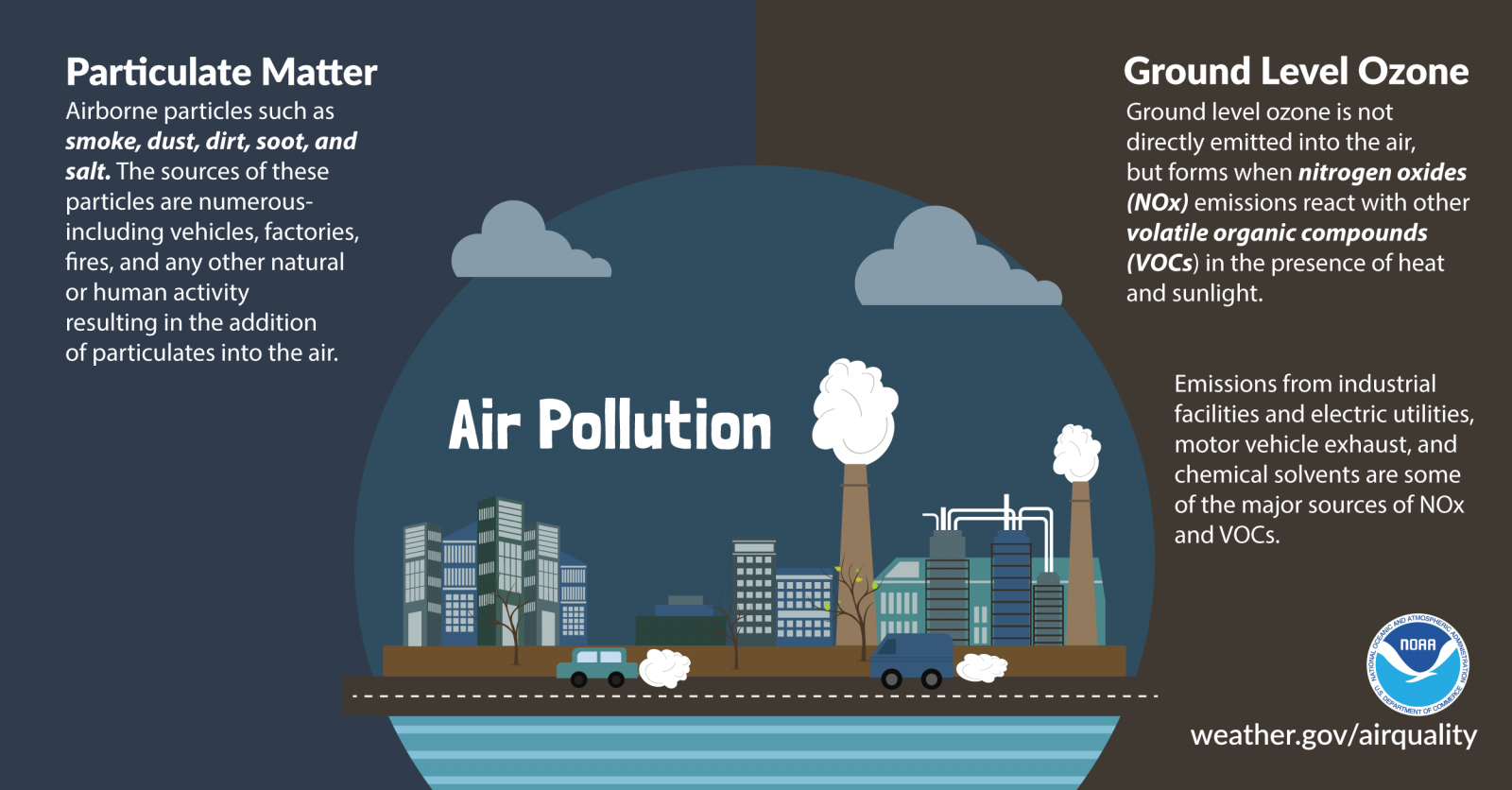
Air Pollution Science
Facebook
What is air pollution? The two primary culprits are: 1) Airborne particles such as smoke, dust, dirt, and soot, also called particulate matter. 2) Ground level ozone, which is formed when nitrogen oxides emissions react with other volatile organic compounds in the presence of heat and sunlight. To learn air quality safety tips, visit weather.gov/safety/airquality
X
What is air pollution? The two primary culprits are particulate matter and ground level ozone. Check out the graphic below, and visit weather.gov/safety/airquality to stay #WeatherReady
Air Pollution Science - Particulate Matter: Airborne particles such as smoke, dust, dirt, soot, and salt. The sources of these particles are numerous - including vehicles, factories, fires, and any other natural or human activity resulting in the addition of particulates into the air. Ground Level Ozone: Ground level ozone is not directly emitted into the air, but forms when nitrogen oxides (NOx) emissions react with other volatile organic compounds (VOCs) in the presence of heat and sunlight. Emissions from industrial facilities and electric utilities, motor vehicle exhaust, and chemical solvents are some of the major sources of NOx and VOCs.
What’s a Flash Drought?
Facebook
What’s a flash drought? Simply put, it is a rapid onset of drought that is associated with hot, dry and windy conditions. Stay Weather-Ready during drought by conserving water and practicing fire prevention. drought.gov/what-is-drought/flash-drought
X
What’s a flash drought? Simply put, it is a rapid onset of drought that usually includes high temperatures and winds. Stay #WeatherReady during drought by conserving water and practicing fire prevention. drought.gov/what-is-drought/flash-drought
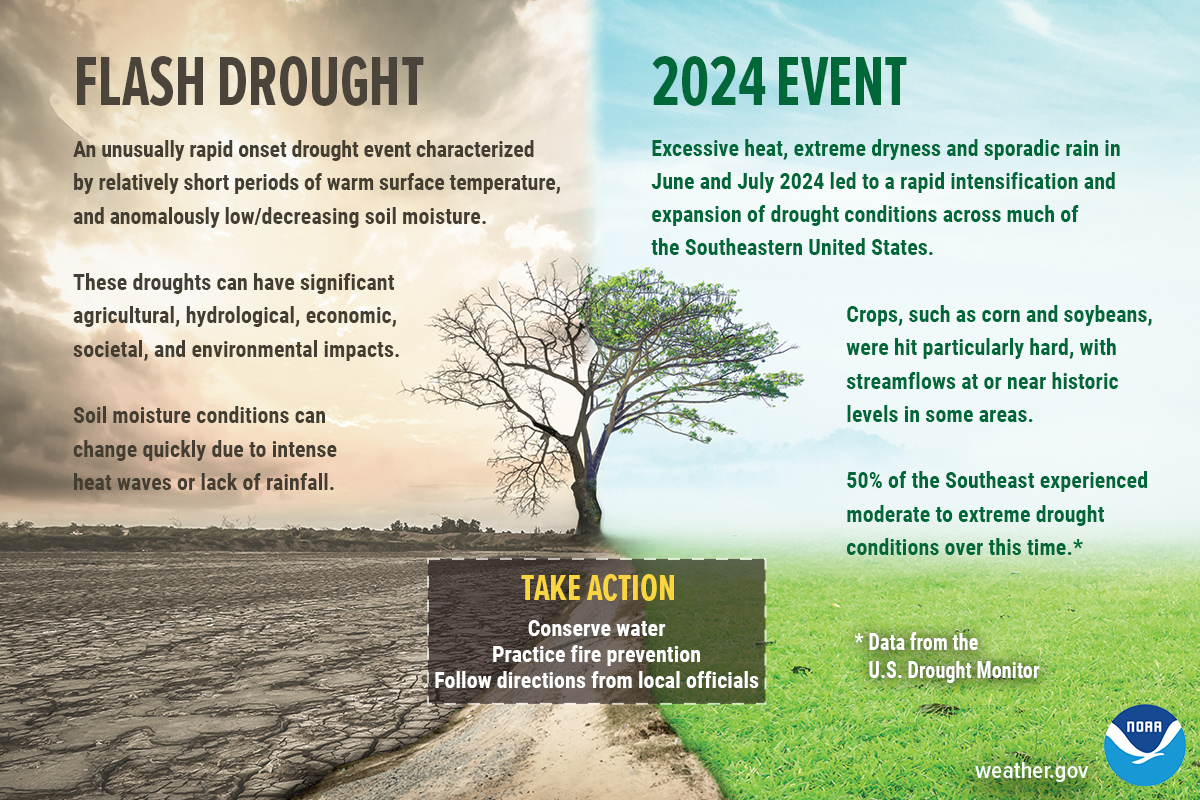
Flash drought is an unusually rapid onset drought event characterized by relatively short periods of warm surface temperature, and anomalously low or decreasing soil moisture. These droughts can have significant agricultural, hydrological, economic, societal, and environment impacts. Soil moisture conditions can change quickly due to intense heat waves or lack of rainfall. The 2017 drought was a rapid-onset event for northeast Montana, the Dakotas, and the Canadian Prairies during the spring and summer of 2017. It was the worst drought to impact the U.S. Northern Plains in decades and it decimated crops, responsible for $2.6 billion in agricultural losses in the U.S. alone (Data from the U.S. Drought Monitor). Take Action: conserve water, practice fire prevention, and follow directions from local officials.Excessive heat, extreme dryness and sporadic rain in June and July 2024 led to a rapid intensification and expansion of drought conditions across much of the Southeastern United States. Crops, such as corn and soybeans, were hit particularly hard, with streamflows at or near historic levels in some areas. 50% of the Southeast experienced moderate to extreme drought conditions over this time.*Data from NIDIS (drought.gov) Take Action: conserve water, practice fire prevention, and follow directions from local officials.
Weird Weather (Video)
Facebook
Haboob. Funny name, dangerous weather phenomenon. Learn about them and other examples of weird weather in this short video: youtu.be/vuk6gvq7Nwk #wxscience
X
Haboob. Funny name, dangerous weather phenomenon. Learn about them and other examples of weird weather in this short video: youtu.be/vuk6gvq7Nwk #wxscience
What is a 500-year flood? (video)
Facebook
The term 500-year flood doesn’t necessarily mean that it’s only going to happen one time every 500 years. Rather, it’s a reference to the probability of occurrence. youtu.be/eQFyaXDH42U #FloodScience
X
The term 500-year flood doesn’t necessarily mean that it’s only going to happen one time every 500 years. Rather, it’s a reference to the probability of occurrence. youtu.be/eQFyaXDH42U #FloodScience
Science of River Flooding
Facebook
Water is essential for life on Earth. But in large enough quantities, the very substance we drink and use to grow crops can destroy homes, businesses, and cause fatalities. Learn all about the science of river flooding in the infographic below, and visit weather.gov/safety/flood for flood safety tips. #FloodScience
X
Learn all about the science of river flooding with this graphic, and visit weather.gov/safety/flood for flood safety tips. #FloodScience
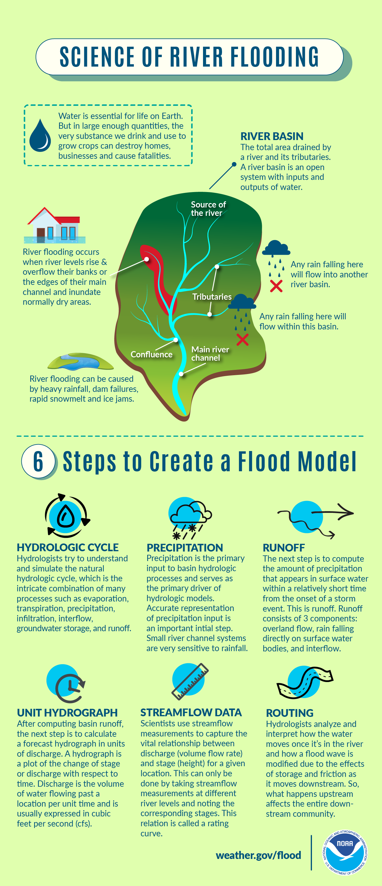
SCIENCE OF RIVER FLOODING - Water is essential for life on Earth. But in large enough quantities, the very substance we drink and use to grow crops can destroy homes, businesses and cause fatalities. River flooding occurs when river levels rise & overflow their banks or the edges of their main channel and inundate normally dry areas. River flooding can be caused by heavy rainfall, dam failures, rapid snowmelt and ice jams. Six Steps to Create a River Model Hydrologic Cycle: Hydrologists try to understand and simulate the natural hydrologic cycle, which is the intricate combination of many processes such as evaporation, transpiration, precipitation, infiltration, interflow, groundwater storage, and runoff. Precipitation: Precipitation is the primary input to basin hydrologic processes and serves as the primary driver of hydrologic models. Accurate representation of precipitation input is an important initial step. Small river channel systems are very sensitive to rainfall. Runoff: The next step is to compute the amount of precipitation that appears in surface water within a relatively short time from the onset of a storm event. This is runoff. Runoff consists of 3 components: overland flow, rain falling directly on surface water bodies, and interflow. Unit Hydrograph: After computing basin runoff, the next step is to calculate a forecast hydrograph in units of discharge. A hydrograph is a plot of the change of stage or discharge with respect to time. Discharge is the volume of water flowing past a location per unit time and is usually expressed in cubic feet per second (cfs). Streamflow Data: Scientists use streamflow measurements to capture the vital relationship between discharge (volume flow rate) and stage (height) for a given location. This can only be done by taking streamflow measurements at different river levels and noting the corresponding stages. This relation is called a rating curve. Routing: Hydrologists analyze and interpret how the water moves once it’s in the river and how a flood wave is modified due to the effects of storage and friction as it moves downstream. So, what happens upstream affects the entire downstream community.
The Geostationary Lightning Mapper
Facebook
Did you know that weather satellite GOES-16 houses the very first operational lightning mapper flown in geostationary orbit? GLM measures total lightning (in-cloud, cloud-to-cloud and cloud-to-ground) activity continuously over the Americas and adjacent ocean regions with near-uniform spatial resolution of approximately 10 km.
When used in conjunction with radar data, GLM trends allow forecasters to make warning decisions earlier and more confidently. goes-r.gov/spacesegment/glm.html
X
Did you know that weather satellite GOES-16 houses the first operational lightning mapper flown in geostationary orbit? The data provided helps forecasters make potentially life-saving decisions. goes-r.gov/spacesegment/glm.html
The Geostationary Lightning Mapper. GLM measurements help the weather, aviation, disaster prep, and fire communities with early warning of lightning strikes, identifying storm intensity, tornado lead times and false alarm reduction, and detection of heavy rainfall and flash flooding.
What are Rip Currents?
Facebook
Rip currents are powerful, narrow channels of water in the surf zone that move quickly away from shore. Moving at speeds of up to eight feet per second (or 5 mph!), rip currents can move faster than an Olympic swimmer. oceantoday.noaa.gov/ripcurrentscience/welcome.html #RipCurrentScience
X
Rip currents are powerful, narrow channels of water flowing away from shore at surf beaches and can reach speeds of 8 feet per second! oceantoday.noaa.gov/ripcurrentscience/welcome.html #RipCurrentScience
What Are Rip Currents? Narrow currents of water flowing away from shore at surf beaches. They commonly form around at breaks in sandbars, and also near structures, such as jetties and piers. Rip currents move at speeds of 1-2 feet per second, but have been measured as fast as 8 feet per second.
Thunderstorm Types (Video)
Facebook
Did you know there are different types of thunderstorms? Watch this video and learn what they are: youtu.be/NNrb0hI5JD4 #ThunderstormScience
X
Did you know there are different types of thunderstorms? Watch this video and learn what they are: youtu.be/NNrb0hI5JD4 #ThunderstormScience
Types of Tornadoes
Facebook
Supercells are not the only types of storms that develop tornadoes. Did you know that there are multiple types of tornadoes that can form? Learn all about them in the infographic below, and visit weather.gov/jetstream/tornado.
X
Did you know that there are multiple types of tornadoes? Visit weather.gov/jetstream/tornado for more info. #WeatherReady
Supercell Tornadoes come from supercell thunderstorms. They are the most common & often the most dangerous. They develop from a rotating column of air (updraft) fed by warm, moist air at ground level. Rotation can come from wind shear: winds at different levels above the ground blow at different speeds or directions. Landspouts: narrow, rope-like condensation funnels that form while the thunderstorm cloud is still growing & there is no rotating updraft. The spinning motion starts near the ground. Waterspouts: Similar to landspouts, but form over water. Gustnadoes: Whirls of dust/debris near the ground with no condensation funnel, forming along a storm’s gust front. Dust Devils: Well-developed whirl, usually short-lived, made visible by dust, sand & debris. Develop on hot, calm afternoons with clear skies, when intense surface heating causes large temperature differences in the lowest few 100 feet of the atmosphere. Fire Whirls: Much like dust devils, but caused by extreme heat of fires
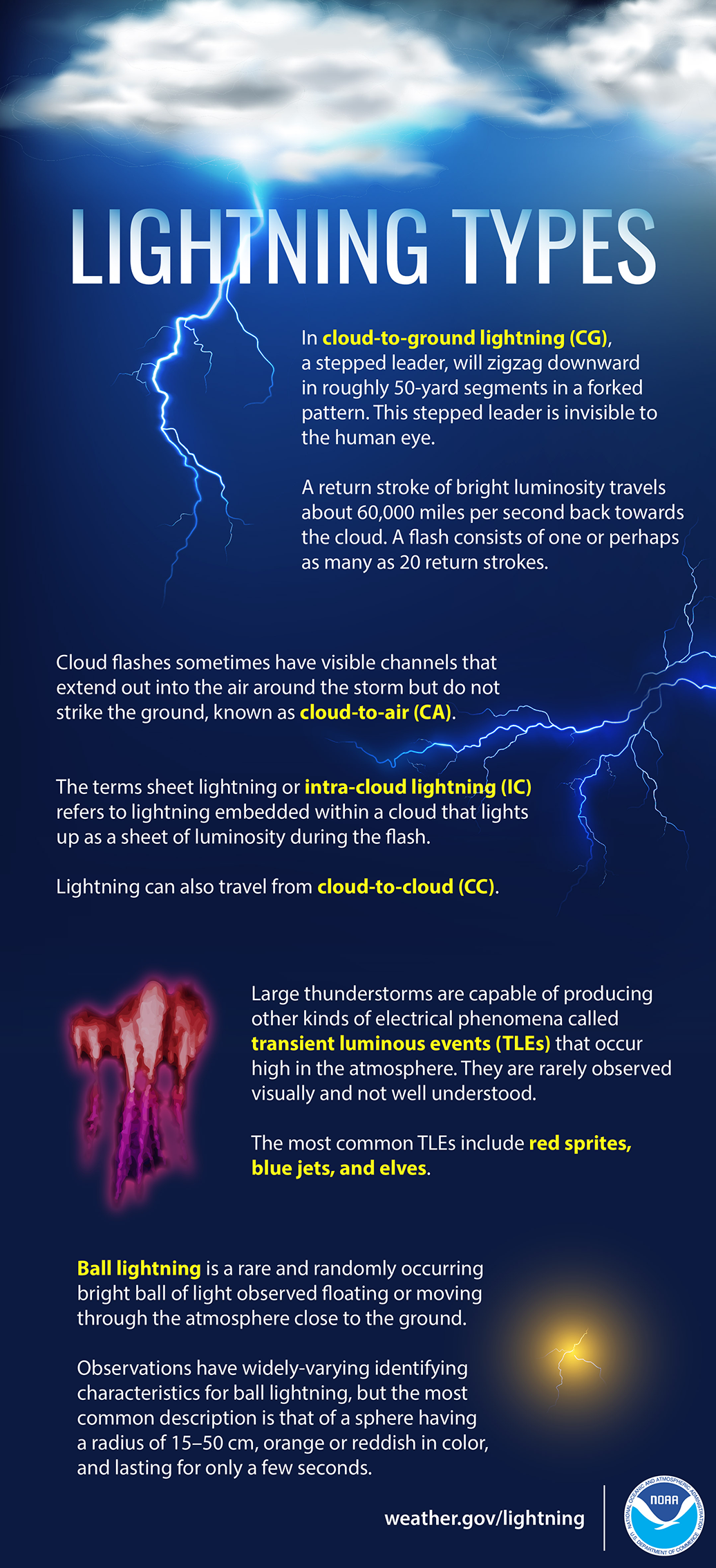
Cloud-to-ground lightning: a stepped leader will zigzag downward in roughly 50-yard segments that are invisible to our eye. A bright return stroke travels about 60,000 miles per second back to the cloud. A flash consists of 1 to 20 return strokes. Cloud-to-air: cloud flashes with visible channels that extend out into the air around the storm but don’t strike the ground. Sheet lightning or intra-cloud lightning: lightning inside a cloud that lights up as a sheet of luminosity during the flash. Lightning can also travel from cloud-to-cloud. Thunderstorms can also produce electrical phenomena called transient luminous events high in the atmosphere. They are rarely seen and not well understood. The most common are red sprites, blue jets, and elves. Ball lightning is a rare and randomly occurring bright ball of light seen floating or moving close to the ground. The most common description is an orange or reddish sphere with a radius of 15–50 cm, lasting only a few seconds.
Speed of Wildfires
Facebook
There are a lot of factors that determine the speed of wildfires. Check out the infographic below to learn a little wildfire science, and visit weather.gov/safety/wildfire for the latest safety tips.
X
There are a lot of factors that determine the speed of wildfires. Check out the infographic below to learn a little #WildfireScience, and visit weather.gov/safety/wildfire for the latest safety tips. #WeatherReady
The Speed of Wildfires: Weather Conditions Wind speed has a huge effect on fire intensity and how fast fires travel. Wind pushes the flame forward and closer to the unburned fuel in front of the fire. Temperature, humidity, and precipitation are also important due to their strong influence on fuel moisture content. Spotting Wind and thermals can carry sparks and firebrands downwind of fires, greatly increasing spread rates. Fuel Type The type of vegetation along with the fuel moisture content, physical properties, and chemical properties play a role in fire behavior and how fast fires spread. Topography Slope steepness affects fire behavior in a similar way as wind by changing the flame angle. Elevation and aspect are also important in determining how fires spread.
Lake Effect Snow
Facebook
Lake Effect snow occurs when cold air moves across warmer water. Warmth and moisture rise into the air, condensing into clouds that can produce 2 to 3 inches of snow per hour or more. Learn more weather science at weather.gov/jetstream
X
Lake Effect snow occurs when cold air moves across warmer water. Warmth and moisture rise into the air, condensing into clouds that can produce 2 to 3 inches of snow per hour or more. Learn more weather science at weather.gov/jetstream
What is lake effect snow? Lake effect snow occurs when cold air, often originating from Canada, moves across the open waters. As the cold air passes over the unfrozen and relatively warm waters, warmth and moisture are transferred into the lowest portion of the atmosphere. The air rises and clouds form and grow into narrows bands that produce 2 to 3 inches of snow per hour or more.
What's a Blizzard?
Facebook
Did you know not all blizzards involve falling snow? By definition, a blizzard includes 35+ mph winds that cause blowing snow, reducing visibility to 1/4 mile or less for at least 3 hours. If the visibility reduction comes from snow that has already fallen, it is called a ground blizzard. Whether or not the snow falls during the time of the blizzard, dangerous conditions can result. Make sure you’re prepared! weather.gov/winter
X
Did you know that not all blizzards involve falling snow? Whether or not the snow falls during the blizzard, dangerous conditions can result. weather.gov/winter Be #WeatherReady!
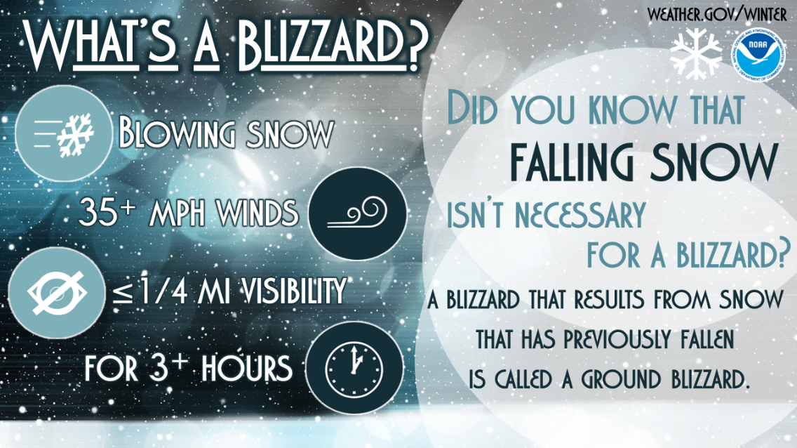
What's a Blizzard? Blowing snow, 35+ mph winds, less than 1/4 mile visibility, for 3+ hours. Did you know that falling snow isn't necessary for a blizzard? A blizzard that results from previously fallen snow is called a ground blizzard.
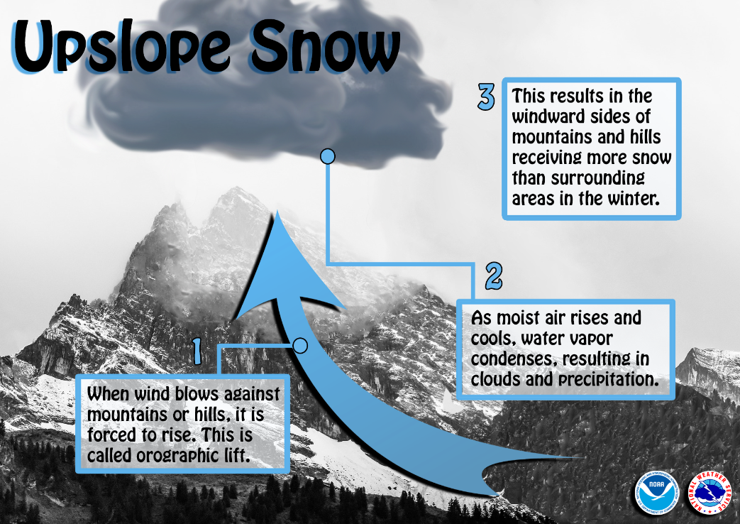
Upslope Snow
Facebook
Have you wondered why the windward side of mountains or large hills receives so much more snow than surrounding areas? This is due to upslope snow. When moist wind blows against the side of mountains/hills, the air is forced to rise (called orographic lift). As the air rises and cools, water vapor condenses, resulting in clouds and precipitation over the windward region. Conversely, the leeward side often receives less snow due to descending air.
X
Why does the windward side of mountains or large hills receive so much more snow than surrounding areas? It’s because of the upslope effect. When you’re in one of these windward areas, make sure you’re #WeatherReady
Upslope Snow: 1) When wind blows against mountains or hills, it is forced to rise. This is called orographic lift. 2) As moist air rises and cools, water vapor condenses, resulting in clouds and precipitation. 3) This results in the windward sides of mountains and hills receiving more snow than surrounding areas in the winter.
Snow Water Cycle
Facebook
During winter months, falling snow serves as an important source of freshwater across the world. When spring arrives, melting snow helps replenish rivers, lakes, and reservoirs. The melting snow adds much-needed moisture to the soil and helps refill underground aquifers, which are vital for growing crops and for drinking water. noaa.gov/jetstream/atmosphere/hydro
Snow Water Cycle: The hydrologic cycle involves the continuous circulation of water in the Earth-Atmosphere system. At its core, the water cycle is the motion of the water from the ground to the atmosphere and back again. During the winter months, falling snow serves as an important source of freshwater across the world. When spring arrives, melting snow helps replenish rivers, lakes and reservoirs. The melting snow adds much needed moisture to the soil and helps refill underground aquifers, which are vital for growing crops and for drinking water.
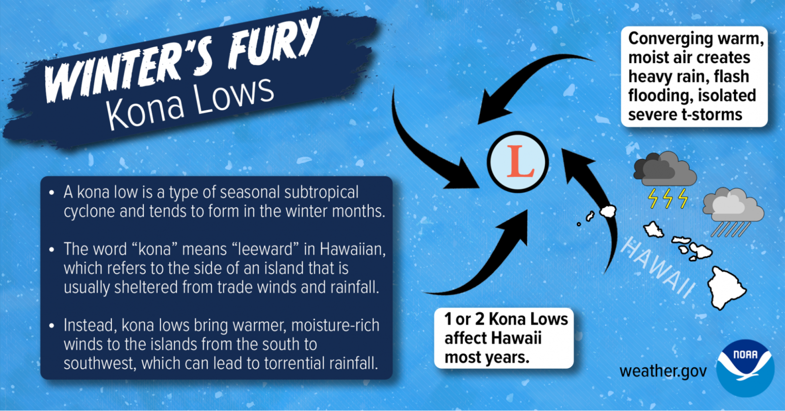
Winter's Fury: Kona Lows
Facebook
Kona lows” are major weather producers in the Hawaiian islands. The word ‘kona’ means ‘leeward’ in Hawaiian, which refers to the side of an island that is usually sheltered from trade winds and rainfall—but not for these storms.
X
“Kona lows” are major weather producers in the Hawaiian islands. The word ‘kona’ means ‘leeward’ in Hawaiian, which refers to the side of an island that is usually sheltered from trade winds and rainfall—but not for these storms.
A kona low is a type of seasonal subtropical cyclone and tends to form in the winter months. The word ‘kona’ means ‘leeward’ in Hawaiian, which refers to the side of an island that is usually sheltered from trade winds and rainfall. Instead, kona lows bring warmer, moisture-rich winds to the islands from the south to southwest, which can lead to torrential rainfall. 1 or 2 kona lows affect Hawaii most years. The converging warm, moist air creates heavy rain, flash flooding, and isolated thunderstorms.
Winter Precipitation
Facebook
Will there be rain, ice, or snow? This graphic explains how having different layers of warm and cold air between the clouds and the ground determines the type of precipitation that hits the ground. nssl.noaa.gov/education/svrwx101/winter/types/
Winter Precipitation: Below 32°F, snowflakes never melt. With sleet, droplets freeze and form ice before reaching the surface. Freezing rain is caused by rain, above 32°F in the sky, freezing on contact with the cold surface. If the surface temperature is above 32°F, rain will not freeze.
Winter’s Fury: Nor’easters
Facebook
Not many winter storms have the potential to bury 100 million people in 1-2 feet of snow in a single day. Nor’easters are notorious for packing strong winds and copious amounts of moisture they get from the Atlantic. The heavily-populated region between Washington D.C., Philadelphia, New York City, and Boston -- the “I-95 Corridor” -- is especially impacted by Nor’easters. weather.gov/safety/winter-noreaster
X
Nor’easters are notorious for big wind and copious amounts of moisture they get from the Atlantic. weather.gov/safety/winter-noreaster #WeatherReady
Winter’s Fury - Nor’easters: Not many winter storms have the potential to bury 100 million people in 1-2 feet of snow in a single day. Nor'easters are notorious for packing big wind and copious amounts of moisture they get from the Atlantic. The heavily populated region between Washington D.C., Philadelphia, New York and Boston, the 'I-95 Corridor', is especially impacted by Nor'easters.
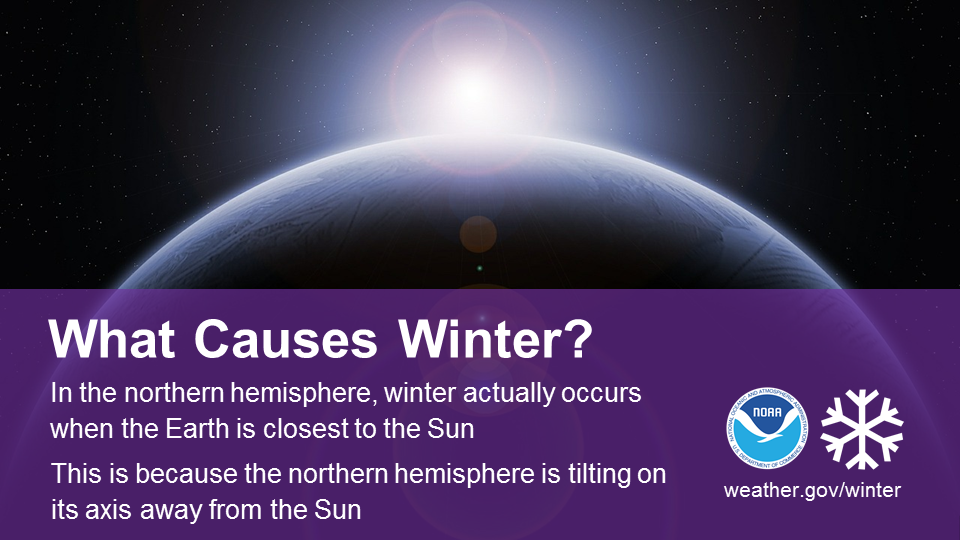
What Causes Winter?
Facebook
Did you know that in the northern hemisphere, winter actually occurs when the Earth is closest to the Sun? This is possible because of the way the Earth tilts on its axis. During winter, the northern hemisphere is tilting away from the Sun, causing the Sun’s rays to hit the northern hemisphere at a lower angle, which results in far lower temperatures. Learn more at scijinks.gov/earths-seasons/
X
In the northern hemisphere, winter actually occurs when the Earth is closest to the Sun. Learn more scijinks.gov/earths-seasons/
What Causes Winter? In the northern hemisphere, winter actually occurs when the Earth is closest to the Sun. This is because the northern hemisphere is tilting on its axis away from the Sun.
Science of Snowflakes
Facebook
Did you know that while no two snowflakes are exactly the same, they are all six-sided? Snowflakes’ hexagonal shapes are due to the molecular structure of ice. Learn more about the science behind snowflakes: noaa.gov/stories/how-do-snowflakes-form-science-behind-snow
Science of Snowflakes: No two snowflakes are the same, but they are all six-sided. Their shapes are due to the molecular structure of ice.
Aurora Colors
Facebook
While the aurora borealis is usually green, why does it sometimes appear to be a range of other colors, including red, blue, pink, and purple? Find out here: swpc.noaa.gov/content/aurora-tutorial
Why does the aurora change colors? The aurora is usually green, but it can be other colors too. The color is determined by the altitude of the aurora. Atmospheric compounds influence the color.
Science of Frost Formation (Video)
Facebook /X
Did you know that frost can form when the official low is above freezing? The official temperature is recorded around 6 feet above the ground, and in a strong temperature inversion on a clear night, ground temps can be 5-10℉ cooler than the air below that. youtu.be/HBn1oSWu2nE
Science of Valley Fog
Facebook
Why do we see fog in valleys more often than other spots? First, air at higher elevations cools down, which then drains downslope into the valley. From there, a cool, stable layer forms near the ground, which limits turbulent mixing and traps the cool, moist air. Finally, the air near the ground continues to cool until water vapor molecules are changed into small droplets of liquid water. weather.gov/safety/fog-mountain-valley
1. Air cools at higher elevations as the ground radiates heat into the atmosphere and space. 2. Cooler air drains downslope into the valley. 3. A cool, stable layer forms the ground, which limits turbulent mixing and traps the cool, moist air. 4. The air near the ground continues to cool until water vapor moleculesd are changed into small droplets of liquid water.
Science of Fog Formation (video)
Facebook
Fog limits visibility, delays air travel, brings danger to the roads, and makes things generally spooky. But, how does it form? Watch this short video: youtu.be/QkRqjcO1ROk
X
Fog limits visibility, delays air travel, brings danger to the roads, and makes things generally spooky. But, how does it form? Watch this short video: youtu.be/QkRqjcO1ROk #FogScience
Science of Wind (Video)
Facebook
Wind is just air moving somewhere else...but WHERE is it going, and WHY? Check out this short video for a primer. youtu.be/kb9oRYUzlwQ
X
Wind is just air moving somewhere else...but WHERE is it going, and WHY? Check out this short video for a primer. youtu.be/kb9oRYUzlwQ #WindScience
Science of Wind Chill
Facebook/X
In calm winds, our body is able to keep a thin layer of warmer air near it. Once the wind picks up, that layer is quickly disrupted, exposing any unprotected body parts to the full brunt of the cold.
Arctic air + brisk winds = dangerously cold wind chills. weather.gov/safety/cold
Infographic - The Science of Wind Chill. The average temperature of the human body is 98.6 degrees fahrenheit. Under calm conditions, the body radiates heat, creating a layer of warmth between your skin and the cold surroundings. But when it's windy, the moving air breaks up this insulating layer. It speeds up heat loss by whisking away the warmth from our skin. Hypothermia begins when our body temperature drops two to four degrees.
Science of Santa Ana Winds
Facebook
Santa Ana winds are strong downslope winds that blow through the mountain passes in Southern California. They are created over the Great Basin region from high-pressure air masses, which then blow down towards sea level. These winds, which can easily exceed 40 miles per hour (18 m/s), are warm and dry and can severely exacerbate brush or forest fires, especially under drought conditions. For more info, visit earthobservatory.nasa.gov/NaturalHazards/view.php?id=10727.
What are Santa Ana Winds? Strong downslope winds. Created over the Great Basin from high-pressure air masses. They are warm, dry, and can worsen forest fires.
Skywarn
Facebook/X
Help keep your community safe by volunteering to become a trained storm spotter and learn:
*Basics of thunderstorm development
*Fundamentals of storm structure
*Identifying potential severe weather
*How to report information
*Basic severe weather safety weather.gov/skywarn
NWS Skywarn: National Weather Service Citizen Science
CoCoRaHS
Facebook/X
Ever wanted to take rain or snow measurements? Join CoCoRaHS or Community Collaborative Rain, Hail, and Snow Network. This volunteer network of all ages measures precipitation from their backyard. Data is used by NWS meteorologists to help with forecasts. www.cocorahs.org
CoCoRaHS: National Weather Service Citizen Science
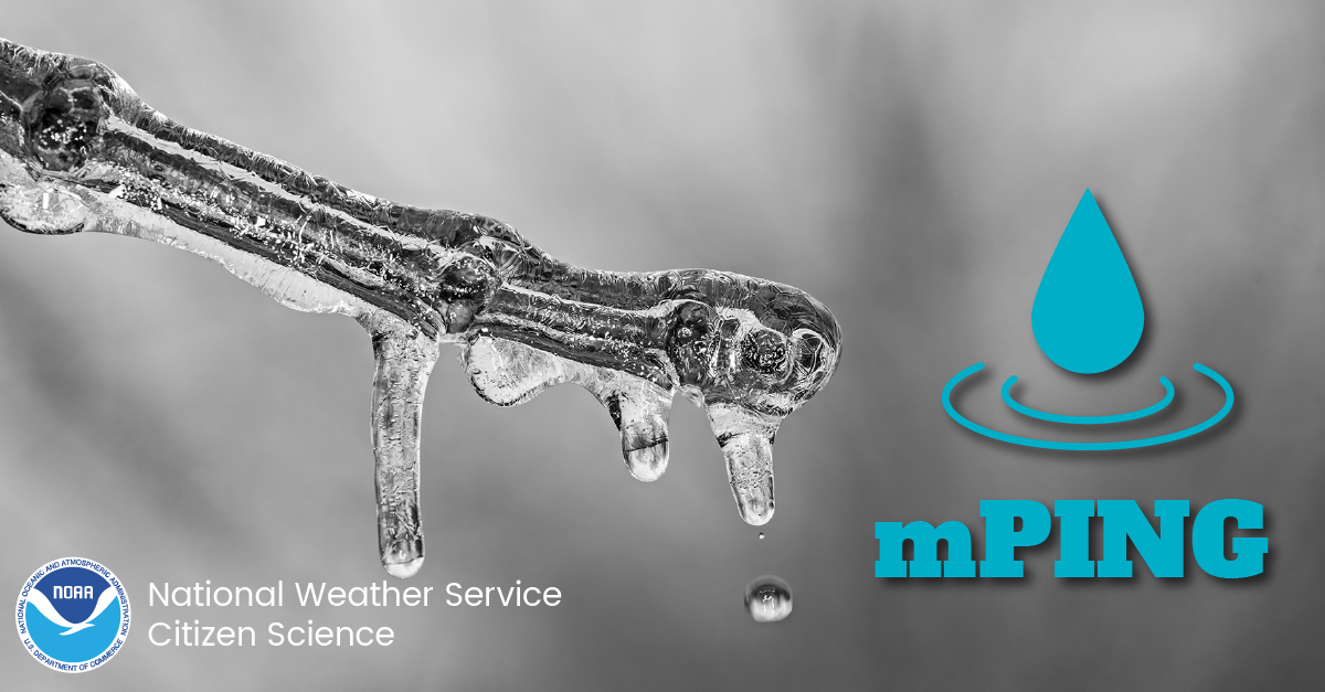
mPING
Facebook
Check out mPING (Meteorological Phenomena Identification Near the Ground) project. Weird name, cool app! You can report the type of precipitation you see where you are. No need to measure! Use the free mobile app to send reports anonymously. Reports are automatically recorded into a database, which improves weather computer models. The information is even used by road maintenance operations and the aviation industry to diagnose areas of icing. mping.nssl.noaa.gov
X
Check out mPING (Meteorological Phenomena Identification Near the Ground) project. Weird name, cool app! YOU can report the type of precipitation you see where you are with no need to measure! Use the free mobile app to send reports anonymously. mping.nssl.noaa.gov
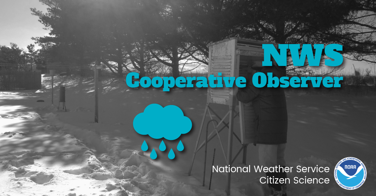
Facebook
The NWS Cooperative Observer Program (COOP) is truly the Nation's weather and climate observing network of, by and for the people. With over 8,700 volunteer observers, this program has existed since 1890 and is one of the few programs that measures snowfall and its water equivalent. Help NWS Citizen Science and become a COOP! You can help support warnings, forecasts, and build a climatological database! For more information, visit weather.gov/coop/Overview
X
Join NWS COOP! The NWS Cooperative Observer Program (COOP) is truly the Nation's weather and climate observing network of, by and for the people. Help support warnings, forecasts & build a climatological database! weather.gov/coop/Overview #NWSCitizenScience