| January 2025 climate report for Tucson |
| 61st coolest and 25th driest on record |
| Earliest first 85° date on record tied |
| Surface dew points were below zero for five straight days |
| |
|
The January outlook from the Climate Prediction Center for Tucson favored above-normal monthly mean temperatures (58% above vs. 9% below) and below-normal total precipitation amounts (59% below vs. 8% above).
|
| |
|
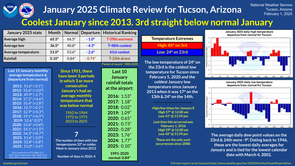
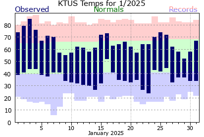
The new year started as 2024 ended, with well above normal temperatures through the 4th, highlighted by a near-record high of 85° on the 3rd. This tied the earliest first 85° or warmer date on record. The average first 85° date on March 4th. Cooler, near or slightly above normal temperatures occurred on the 5th through the 8th.
|
| |
|
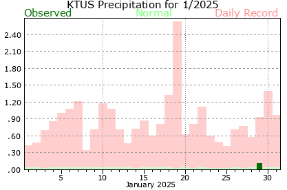
A weather system moving across northern Sonora Mexico brought scattered sprinkles to very light showers to the metro area on the 8th. A cooler air mass settled in with this system and remained here through the 14th. High temperatures were in the mid to upper 50s on the 8th, 9th & 10th, then in the upper 50s to the lower 60s from the 11th through the 14th. Low temperatures were in the mid to upper 30s on the 9th, gradually getting colder over the next several mornings with mid-20s to the lower 30s on the 12th and 13th, and then the 20s with isolated areas in the upper teens on the 14th. The low temperature at the airport on the 11th of 32° ended a record streak of 364 days of nonfreezing low temperatures. The previous record was 351 days from 2014.
|
| |
|
A brief warm-up on the 15th & 16th with the highs in the lower 70s. Due to gusty easterly winds on the morning of the 16th, the low temperatures across the metro area ranged from the upper 30s to the lower 50s with the airport recording a low of 52°.
|
| |
|
Cooler than normal temperatures settled in again across the area for the next week with high temperatures mostly in the lower to mid-60s and lows in the 30s. During this period, the surface moisture was really dry with the dew points being below zero from the 21st through the 25th with daily low average dew point records being set on the 23rd & 24th at 9° below zero. Due to the very dry near surface air and clear skies on these days, low temperatures were in the 20s to mid-30s with low temperatures at the airport being 27° on the 22nd and 24° on the 23rd. The 24° is the coldest low temperature at the airport since February 5, 2020, and the coldest in January since 2013 when it was 17° on the 13th and 24° on the 14th.
|
| |
|
Warmer temperatures settled in over a three-day period from the 24th to 26th with highs in the lower 70s and lows in the lower to mid-40s.
|
| |
|
A colder weather system moved into the area on the 28th and 29th bringing the first widespread precipitation to the area since November 3rd. The last five days of the month had highs in the 50s to mid-60s while lows were mostly in the 30s.
|
| |
|
The monthly average temperature of 51.0° is 2.6° below normal and ranks as the 61st coolest January on record. Temperature extremes for the month ranged from a high of 85° on the 3rd to a low of 24° on the 23rd. There was a total of 7 days with freezing low temperatures which is the most in January since 2013 when there were 12 days. On a side note, there were only 4 days with freezing low temperatures in all of 2024.
|
| |
|
Rainfall amounts, using several sources like rainlog.org, the Pima County Regional Flood Control District gages, and CoCoRaHS, ranged from trace to 0.25". The Tucson International Airport, the official recording spot in Tucson, recorded 0.10" which is nearly three-quarters of an inch below normal and ranks as the 25th driest January on record. The first four months of the hydrological water year, October through January, have been really dry with only 0.53" being recorded at the airport. This ranks as the 4th driest first four months of the water year on record.
|
| |
| January 2025 stats |
Month
|
Normal
|
Departure
|
Historical Ranking
|
| Average high temperature |
65.5°
|
66.5°
|
- 1.0°
|
T-59th warmest
|
| Average low temperature |
36.5°
|
40.8°
|
- 4.3°
|
T-48th coolest
|
| Average temperature |
51.0°
|
53.6°
|
- 2.6°
|
61st coolest
|
| Rainfall |
0.10"
|
0.84"
|
- 0.74"
|
T-25th driest
|
| Water year rainfall (Oct-Jan) |
0.53"
|
3.03"
|
- 2.50"
|
4th driest
|
|
Period of record: 131 years (1895-2025)
|
|
| |
| Winter 2024-2025 (so far) |
|
One month remains in climatological Winter and so far it has been warmer (55.3° or +1.9°) and drier (0.10" or -1.54") than normal. The historical Winter precipitation ranking with one month left stands at 2nd driest.
|
| |
|
Looking ahead into February
|
|
A weak La Niña will continue in the equatorial Pacific through the end of Winter. The February outlook from the Climate Prediction Center for Tucson favors above normal monthly mean temperatures (40% above vs. 27% below) and leans slightly to below-normal total precipitation amounts (34% below vs. 33% above).
|
| |
| Normal monthly high temperature |
69.2° |
| Normal monthly low temperature |
43.2° |
| Normal monthly temperature |
56.2° |
| Record high temperature |
92° on February 14, 1957 |
| Record low temperature |
17° on February 7, 1899 |
| Warmest February (avg.) |
62.1° in 2015 |
| Coldest February (avg.) |
45.3° in 1903 |
| Normal rainfall |
0.84" |
| Wettest February day |
1.26" on February 7, 1966 |
| Wettest February |
4.15" in 1905 |
| Driest February |
0.00" in 1898, 1972, 1984 & 2021 |
| Snowiest February |
4.9" in 1903 |
| Daily normals | Daily records |
|
|
| The number of daylight hours will increase from 10 hours 40 minutes 22 seconds on the 1st to 11 hours 29 minutes 03 seconds on the 29th, again of 48 minutes 41 seconds. |
| |
| Glueck |


