Fire Weather Forecast:
|
104 FNUS55 KTFX 190851 FWFTFX Fire Weather Planning Forecast for North-Central Montana National Weather Service Great Falls MT 251 AM MDT Sat Apr 19 2025 .DISCUSSION... Southwesterly winds increase today ahead of an approaching cold front, with wind gusts around 40 mph at times over zones 112 and 114. The front will move in a northwest to southeast fashion this afternoon and bring a northwesterly wind shift followed by scattered shower activity. A broad trough then remains over the Northern Rockies through at least the middle of next week, with periods of lower elevation rain showers, mountain snow, and a few isolated thunderstorms. MTZ112-192215- Eastern Glacier/Toole/Central/Eastern Pondera/Liberty- 251 AM MDT Sat Apr 19 2025 .TODAY... * Sky/Weather...........Partly sunny. Chance of showers in the afternoon. * Max Temperature.......52-62...42-52 higher elevations. 24 hr trend......6 degrees up...unchanged higher elevations. * Min Humidity..........34-44 percent...48-58 percent higher elevations. 24 hr trend......13 percent up. * Wind (20 FT). Lower Elevations...Windy. West winds 20 to 25 mph. Ridges.............Windy. West winds 20 to 25 mph. * CWR...................0 percent. .TONIGHT... * Sky/Weather...........Mostly cloudy. Chance of showers in the evening. Slight chance of showers after midnight. * Min Temperature.......32-37. 24 hr trend......3 degrees up. * Max Humidity..........82-92 percent. 24 hr trend......30 percent up. * Wind (20 FT). Lower Elevations...West winds 15 to 20 mph. Ridges.............West winds 15 to 20 mph. * CWR...................10 percent. .SUNDAY... * Sky/Weather...........Partly sunny. Chance of rain and snow showers in the morning, then showers likely in the afternoon. * Max Temperature.......48-56...40-47 higher elevations. 24 hr trend......7 degrees down...1 degree down higher elevations. * Min Humidity..........45-55 percent...55-65 percent higher elevations. 24 hr trend......12 percent up. * Wind (20 FT). Lower Elevations...Northwest winds 10 to 15 mph shifting to the southwest in the afternoon. Ridges.............Northeast winds 15 to 20 mph shifting to the south in the afternoon. * CWR...................10 percent. .FORECAST DAYS 3 THROUGH 7...... .MONDAY...Mostly cloudy. Showers likely and chance of snow showers. Lows in the lower 30s. Highs in the upper 40s. West winds 20 to 25 mph. .TUESDAY...Mostly cloudy. Chance of rain and snow showers. Lows in the upper 20s. Highs in the upper 40s. Northwest winds 20 to 25 mph. .WEDNESDAY...Partly cloudy. Slight chance of showers. Lows in the upper 20s. Highs in the mid 50s. South winds 10 to 15 mph. .THURSDAY...Partly cloudy. Slight chance of showers. Lows in the lower 30s. Highs in the mid 50s. .FRIDAY...Mostly cloudy. Chance of showers. Lows in the lower 30s. Highs in the mid 50s. $$ MTZ113-192215- Hill and Blaine Counties- 251 AM MDT Sat Apr 19 2025 .TODAY... * Sky/Weather...........Mostly sunny. * Max Temperature.......61-66...55-60 higher elevations. 24 hr trend......10 degrees up. * Min Humidity..........27-36 percent. 24 hr trend......18 percent up...6 percent up higher elevations. * Wind (20 FT). Lower Elevations...Southwest winds 15 to 20 mph shifting to the west in the afternoon. Ridges.............West winds 15 to 20 mph. * CWR...................0 percent. .TONIGHT... * Sky/Weather...........Mostly cloudy. Chance of showers. * Min Temperature.......34-40. 24 hr trend......5 degrees up. * Max Humidity..........84-94 percent. 24 hr trend......32 percent up. * Wind (20 FT). Lower Elevations...North winds 15 to 20 mph. Ridges.............Northwest winds 10 to 20 mph. * CWR...................10 percent. .SUNDAY... * Sky/Weather...........Partly sunny. Slight chance of showers in the morning, then chance of showers in the afternoon. * Max Temperature.......54-59. 24 hr trend......7 degrees down. * Min Humidity..........40-48 percent. 24 hr trend......9 percent up...15 percent up higher elevations. * Wind (20 FT). Lower Elevations...East winds 10 to 15 mph. Ridges.............Northwest winds 10 to 15 mph shifting to the southwest in the afternoon. * CWR...................10 percent. .FORECAST DAYS 3 THROUGH 7...... .MONDAY...Showers likely. Lows in the mid 30s. Highs in the lower 50s. Southwest winds 15 to 20 mph. .TUESDAY...Mostly cloudy. Chance of rain and snow showers. Lows in the lower 30s. Highs around 50. Northwest winds 20 to 25 mph. .WEDNESDAY...Mostly clear. Slight chance of showers. Lows in the upper 20s. Highs in the upper 50s. Southeast winds 15 to 20 mph. .THURSDAY...Partly cloudy. Slight chance of showers. Lows in the lower 30s. Highs in the upper 50s. .FRIDAY...Mostly cloudy. Slight chance of showers. Lows in the mid 30s. Highs in the upper 50s. $$ MTZ114-192215- Lewis and Clark National Forest Rocky Mountain District- Rocky Mountain Front- 251 AM MDT Sat Apr 19 2025 .TODAY... * Sky/Weather...........Mostly sunny then becoming mostly cloudy. Chance of showers in the afternoon. * Max Temperature.......53-63...39-49 higher elevations. 24 hr trend......8 degrees up. * Min Humidity..........32-42 percent...52-62 percent higher elevations. 24 hr trend......13 percent up...1 percent up higher elevations. * Wind (20 FT). Lower Elevations...West winds 20 to 30 mph. Ridges.............Windy. West winds 20 to 30 mph. * CWR...................0 percent. .TONIGHT... * Sky/Weather...........Mostly cloudy. Chance of showers in the evening. Chance of snow showers through the night. Slight chance of showers after midnight. * Min Temperature.......30-36. 24 hr trend......Unchanged...7 degrees up higher elevations. * Max Humidity..........71-81 percent...80-90 percent higher elevations. 24 hr trend......20 percent up. * Wind (20 FT). Lower Elevations...West winds 15 to 25 mph. Ridges.............Windy. West winds 15 to 25 mph. * CWR...................10 percent. .SUNDAY... * Sky/Weather...........Partly sunny. Chance of snow showers and slight chance of showers in the morning, then chance of rain and snow showers likely in the afternoon. * Max Temperature.......50-58...36-46 higher elevations. 24 hr trend......6 degrees down...1 degree up higher elevations. * Min Humidity..........37-47 percent...60-70 percent higher elevations. 24 hr trend......10 percent up. * Wind (20 FT). Lower Elevations...Southwest winds 15 to 20 mph. Ridges.............Southwest winds 15 to 20 mph. * CWR...................10 percent. .FORECAST DAYS 3 THROUGH 7...... .MONDAY...Windy. Snow showers with showers likely. Lows in the lower 30s. Highs in the upper 40s. West winds around 25 mph. .TUESDAY...Windy. Mostly cloudy. Chance of snow showers and showers. Lows in the upper 20s. Highs in the upper 40s. West winds around 25 mph. .WEDNESDAY...Partly cloudy. Chance of snow showers and slight chance of showers. Lows in the upper 20s. Highs in the lower 50s. West winds 15 to 20 mph. .THURSDAY...Partly cloudy. Chance of snow showers and slight chance of showers. Lows in the lower 30s. Highs in the lower 50s. .FRIDAY...Mostly cloudy. Chance of rain and snow showers. Lows in the mid 30s. Highs in the mid 50s. $$ MTZ115-192215- Chouteau and Fergus Counties- 251 AM MDT Sat Apr 19 2025 .TODAY... * Sky/Weather...........Mostly sunny. * Max Temperature.......61-66...54-60 higher elevations. 24 hr trend......11 degrees up. * Min Humidity..........25-34 percent. 24 hr trend......13 percent up...2 percent down higher elevations. * Wind (20 FT). Lower Elevations...Southwest winds 15 to 20 mph shifting to the west in the afternoon. Ridges.............West winds 15 to 20 mph. * CWR...................0 percent. .TONIGHT... * Sky/Weather...........Mostly cloudy. Chance of showers. * Min Temperature.......36-42. 24 hr trend......8 degrees up. * Max Humidity..........75-85 percent. 24 hr trend......26 percent up...12 percent up higher elevations. * Wind (20 FT). Lower Elevations...West winds 10 to 20 mph. Ridges.............West winds 10 to 20 mph. * CWR...................0 percent. .SUNDAY... * Sky/Weather...........Partly sunny. Slight chance of showers in the morning, then chance of showers in the afternoon. * Max Temperature.......55-60...47-53 higher elevations. 24 hr trend......6 degrees down. * Min Humidity..........39-47 percent. 24 hr trend......9 percent up...16 percent up higher elevations. * Wind (20 FT). Lower Elevations...West winds 10 to 15 mph. Ridges.............West winds 10 to 15 mph. * CWR...................10 percent. .FORECAST DAYS 3 THROUGH 7...... .MONDAY...Mostly cloudy with showers. Lows in the upper 30s. Highs in the mid 50s. West winds 20 to 25 mph. .TUESDAY...Windy. Mostly cloudy. Chance of rain and snow showers. Lows in the lower 30s. Highs in the lower 50s. West winds around 25 mph. .WEDNESDAY...Partly cloudy. Slight chance of showers. Lows in the lower 30s. Highs in the mid 50s. Southeast winds 15 to 20 mph. .THURSDAY...Partly cloudy. Slight chance of showers. Lows in the mid 30s. Highs in the upper 50s. .FRIDAY...Mostly cloudy. Chance of showers. Lows in the upper 30s. Highs in the upper 50s. $$ MTZ116-192215- Lincoln Ranger District of the Helena National Forest- 251 AM MDT Sat Apr 19 2025 .TODAY... * Sky/Weather...........Mostly sunny then becoming mostly cloudy. Chance of showers in the afternoon. * Max Temperature.......52-58...41-51 higher elevations. 24 hr trend......10 degrees up. * Min Humidity..........35-44 percent...46-56 percent higher elevations. 24 hr trend......14 percent up. * Wind (20 FT). Lower Elevations...West winds 15 to 20 mph. Ridges.............West winds 15 to 20 mph. * CWR...................0 percent. .TONIGHT... * Sky/Weather...........Mostly cloudy. Chance of rain and snow showers in the evening, then slight chance of rain and snow showers after midnight. * Min Temperature.......28-34. 24 hr trend......5 degrees up. * Max Humidity..........82-92 percent. 24 hr trend......21 percent up. * Wind (20 FT). Lower Elevations...West winds 10 to 20 mph. Ridges.............West winds 10 to 20 mph. * CWR...................10 percent. .SUNDAY... * Sky/Weather...........Partly sunny. Slight chance of snow showers in the morning, then showers and snow showers likely in the afternoon. * Max Temperature.......49-55...39-49 higher elevations. 24 hr trend......5 degrees down. * Min Humidity..........45-55 percent...54-64 percent higher elevations. 24 hr trend......6 percent up. * Wind (20 FT). Lower Elevations...West winds 10 to 20 mph. Ridges.............West winds 10 to 20 mph. * CWR...................10 percent. .FORECAST DAYS 3 THROUGH 7...... .MONDAY...Windy. Snow showers and chance of showers. Lows in the upper 20s. Highs around 40. West winds around 25 mph. .TUESDAY...Windy. Partly cloudy. Chance of snow showers. Lows in the mid 20s. Highs in the mid 40s. West winds around 25 mph. .WEDNESDAY...Partly cloudy. Slight chance of rain and snow showers. Lows in the upper 20s. Highs in the upper 40s. Northwest winds 15 to 20 mph. .THURSDAY...Partly cloudy. Chance of rain and snow showers. Lows around 30. Highs around 50. .FRIDAY...Mostly cloudy. Chance of showers and slight chance of snow showers. Lows in the lower 30s. Highs in the lower 50s. $$ MTZ117-192215- Central and Eastern Lewis and Clark National Forest Areas- 251 AM MDT Sat Apr 19 2025 .TODAY... * Sky/Weather...........Mostly sunny. * Max Temperature.......55-65...46-56 higher elevations. 24 hr trend......7 degrees up. * Min Humidity..........30-40 percent. 24 hr trend......6 percent up. * Wind (20 FT). Lower Elevations...West winds 15 to 20 mph. Ridges.............West winds 15 to 20 mph. * CWR...................0 percent. .TONIGHT... * Sky/Weather...........Mostly cloudy. Chance of showers through the night. Chance of snow showers after midnight. * Min Temperature.......29-38. 24 hr trend......2 degrees up...9 degrees up higher elevations. * Max Humidity..........75-85 percent. 24 hr trend......12 percent up...25 percent up higher elevations. * Wind (20 FT). Lower Elevations...West winds 10 to 20 mph. Ridges.............West winds 10 to 20 mph. * CWR...................10 percent. .SUNDAY... * Sky/Weather...........Partly sunny. Slight chance of rain and snow showers in the morning, then chance of showers in the afternoon. * Max Temperature.......51-60...43-51 higher elevations. 24 hr trend......8 degrees down...3 degrees down higher elevations. * Min Humidity..........39-49 percent. 24 hr trend......9 percent up. * Wind (20 FT). Lower Elevations...West winds 15 to 20 mph. Ridges.............West winds 15 to 20 mph. * CWR...................10 percent. .FORECAST DAYS 3 THROUGH 7...... .MONDAY...Windy. Showers, snow showers and slight chance of thunderstorms. Lows in the lower 30s. Highs in the upper 40s. West winds around 25 mph. .TUESDAY...Windy. Mostly cloudy. Chance of snow showers and showers. Lows in the upper 20s. Highs in the upper 40s. West winds around 30 mph. .WEDNESDAY...Partly cloudy. Chance of rain and snow showers. Lows in the upper 20s. Highs in the lower 50s. South winds 15 to 20 mph. .THURSDAY...Partly cloudy. Chance of showers and slight chance of snow showers. Lows in the lower 30s. Highs in the lower 50s. .FRIDAY...Mostly cloudy. Chance of rain and snow showers. Lows in the mid 30s. Highs in the mid 50s. $$ MTZ118-192215- Helena and Townsend Ranger Districts of the Helena National Forest- 251 AM MDT Sat Apr 19 2025 .TODAY... * Sky/Weather...........Mostly sunny. Slight chance of showers in the afternoon. * Max Temperature.......55-62...45-54 higher elevations. 24 hr trend......15 degrees up. * Min Humidity..........30-40 percent. 24 hr trend......4 percent up...13 percent up higher elevations. * Wind (20 FT). Lower Elevations...South winds 15 to 20 mph shifting to the west in the afternoon. Ridges.............West winds 20 to 25 mph. * CWR...................0 percent. .TONIGHT... * Sky/Weather...........Mostly cloudy. Chance of showers through the night. * Min Temperature.......32-37. 24 hr trend......5 degrees up. * Max Humidity..........79-89 percent. 24 hr trend......23 percent up. * Wind (20 FT). Lower Elevations...Northwest winds 15 to 20 mph shifting to the southwest after midnight. Ridges.............Windy. West winds around 25 mph decreasing to 15 to 20 mph after midnight. * CWR...................10 percent. .SUNDAY... * Sky/Weather...........Partly sunny. Chance of showers in the afternoon. * Max Temperature.......51-58...42-51 higher elevations. 24 hr trend......3 degrees down. * Min Humidity..........37-47 percent. 24 hr trend......9 percent up. * Wind (20 FT). Lower Elevations...Southwest winds 10 to 15 mph. Ridges.............Southwest winds 10 to 15 mph. * CWR...................10 percent. .FORECAST DAYS 3 THROUGH 7...... .MONDAY...Windy. Showers with possible showers and thunderstorms likely. Lows in the lower 30s. Highs in the mid 40s. West winds around 25 mph. .TUESDAY...Windy. Partly cloudy. Chance of snow showers and slight chance of showers. Lows in the upper 20s. Highs in the upper 40s. West winds around 30 mph. .WEDNESDAY...Partly cloudy. Chance of snow showers and slight chance of showers. Lows in the lower 30s. Highs in the lower 50s. North winds 15 to 20 mph. .THURSDAY...Partly cloudy. Slight chance of rain and snow showers. Lows in the lower 30s. Highs in the mid 50s. .FRIDAY...Mostly cloudy with chance of rain and snow showers. Lows in the mid 30s. Highs in the upper 50s. $$ weather.gov/greatfalls |
 |
 |
 |
| Fire Weather Risk - Day 1 Click to Enlarge |
Fire Weather Risk - Day 2 Click to Enlarge |
Fire Weather Risk - Day 3 Click to Enlarge |
|
Enhanced Hazardous Weather Outlook
GFDI images through Day 7 can be found in the "Hazards" Tab. Click here for a detailed breakdown of all mentioned hazards. |
Note: The table and site above are an experimental product to support preparedness and response efforts prior to and during hazardous weather. Users should use in conjunction with checking the latest forecast and, if needed, consulting with a meteorologist. Feedback is always welcomed on this or any product.
Current Hazards- Click On Right Menu For More Options Temperature | Relative Humidity | Wind | Precipitation Temperature |​ Relative Humidity | Wind | Precipitation Temperature |​ Relative Humidity | Wind | Precipitation Today's Liquid Precipitation Forecast Click to Enlarge Tomorrow's Liquid Precipitation Forecast Click to Enlarge
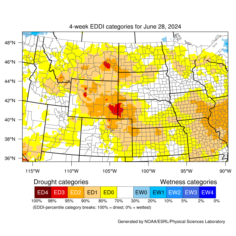
Open the mobile friendly version here: https://m.wfas.net SPC Fire Weather Outlooks Climate Prediction Center (CPC) 6-10 Day Temperature Outlook Click to Enlarge Climate Prediction Center (CPC) 6-10 Day Precipitation Outlook Click to Enlarge Climate Prediction Center (CPC) 8-14 Day Temperature Outlook Click to Enlarge Climate Prediction Center (CPC) 8-14 Day Precipitation Outlook Click to Enlarge Latest U.S. Drought Monitor for Montana Click to Enlarge Latest U.S. Drought Monitor 12 Week Loop Click to Enlarge Latest 4-week Evaporative Demand Drought Index (EDDI) Click to Enlarge Contact: For questions, comments, or additional information please contact us anytime at 1-406-952-3790 *. You can also find us on Facebook, Twitter, and YouTube. *Note: Phone number above is not for public dissemination. Please refer the public calls to 1-406-453-2081. Social Media
Hazards
Thunderstorms
Weather Forecast
Area Forecast Discussion
Outlooks
Contact Us
Day 1 Fire Weather Risk
Click to EnlargeDay 2 Fire Weather Risk
Click to EnlargeDay 3 Fire Weather Risk
Click to Enlarge


Day 4 Fire Weather Risk
Click to EnlargeDay 5 Fire Weather Risk
Click to EnlargeDay 6 Fire Weather Risk
Click to Enlarge

Day 7 Fire Weather Risk
Click to Enlarge


SPC Day 1 Convective Outlook
Click to EnlargeSPC Day 2 Convective Outlook
Click to EnlargeSPC Day 3 Convective Outlook
Click to Enlarge


Day 1 Forecast High Temperatures
Click to EnlargeDay 2 Forecast High Temperatures
Click to EnlargeDay 3 Forecast High Temperatures
Click to Enlarge


Day 1 Forecast Low Temperatures
Click to EnlargeDay 2 Forecast Low Temperatures
Click to EnlargeDay 3 Forecast Low Temperatures
Click to Enlarge


Day 1 Forecast Minimum Relative Humidity (RH)
Click to EnlargeDay 2 Forecast Minimum Relative Humidity (RH)
Click to EnlargeDay 3 Forecast Minimum Relative Humidity (RH)
Click to Enlarge


Day 1 Forecast Maximum Relative Humidity (RH)
Click to EnlargeDay 2 Forecast Maximum Relative Humidity (RH)
Click to EnlargeDay 3 Forecast Maximum Relative Humidity (RH)
Click to Enlarge


Wind forecast for the next 3 hours
Click to EnlargeWind forecast for the next 3-6 hours
Click to EnlargeWind forecast for the next 6-9 hours
Click to Enlarge


Wind forecast for the next 9-12 hours
Click to EnlargeWind forecast for the next 12-15 hours
Click to EnlargeWind forecast for the next 15-18 hours
Click to Enlarge


Wind forecast for the next 18-21 hours
Click to EnlargeWind forecast for the next 21-24 hours
Click to EnlargeWind forecast for the next 24-27 hours
Click to Enlarge

Peak Winds over the next 3 Days
Click to Enlarge


NWS 3 Day Precipitation Forecast
Click to EnlargeWPC 5 Day Precipitation Forecast
Click to EnlargeWPC 7 Day Precipitation Forecast
Click to Enlarge

NWS 3 Day Snow Forecast
Click to Enlarge
983
FXUS65 KTFX 191143
AFDTFX
Area Forecast Discussion
National Weather Service Great Falls MT
543 AM MDT Sat Apr 19 2025
Aviation Section Updated.
.KEY MESSAGES...
- A cold front will usher in a return to unsettled conditions
later today through at least the middle of next week, with
periods of lower elevation rain showers, mountain snow, and
isolated thunderstorms.
- Afternoon temperatures warm as much as 5 to 10 degrees
above average today before cooling closer to seasonal averages
for the remainder of the forecast period.
&&
.DISCUSSION...
/Issued 249 AM MDT Sat Apr 19 2025/
- Meteorological Overview:
Southwesterly surface winds are increasing along the Rocky
Mountain Front and adjacent high plains this morning as a trough
approaches from the northwest. Expect a mild and breezy to windy
day before the cold front slides southeastward and brings
scattered showers and a northerly wind shift this afternoon and
evening. Aside from a few wind gusts over 40 mph along the Rocky
Mountain Front, there are not too many concerns with today`s winds
and shower activity.
The broad and low amplitude mid- level trough will bring an
extended period of unsettled weather, continuing through at least
the middle of next week, with scattered showers, mountain snow,
and isolated thunderstorms. Precipitation amounts through Sunday
evening will generally range from trace amounts at lower
elevations to around a tenth to a couple tenths an inch in the
mountains. Snow levels will generally be at or above pass level
through Sunday evening and may even rise above 7,000 ft over
Central and Southwest Montana Sunday afternoon due to warm air
advection ahead of the main trough axis.
Then the colder H700/H500 (-10C/-25C) temperatures move in Sunday
night and Monday and lower snow levels back to pass level and
below. Rain and snow amounts do increase on Monday, but the
trough`s broad nature and more diffuse frontogenetic forcing
should limit winter impacts. Although less numerous, scattered
showers, light mountain snow, and isolated thunderstorm activity
will continue Tuesday through Thursday with the aforementioned
trough remaining over the Northern Rockies, albeit in a weakening
state.
Most ensembles continue to highlight a split trough along the
Pacific coast bringing weak southwesterly flow aloft over the
Northern Rockies next Friday. Eventually the trough moves into the
interior west, but its evolution is uncertain at this time.
Currently there is an expectation for at least lower grade
unsettled conditions and near average temperatures heading into
next weekend. - RCG
- Forecast Confidence & Scenarios:
Rain, snow, and isolated thunderstorms Sunday through Thursday...
Although the trough will take its time passing through the
Northern Rockies, a broader, less amplified system looks to result
in less impactful rain and snow. The steadiest and heaviest
precipitation is expected Sunday night through Tuesday morning
when the trough`s cold pool is overhead and snow levels are
lowest.
The best chance (60 to 90%) for rain/snow amounts in excess of a
half inch/2 inches during this timeframe is currently reserved for
mountain areas. There is also a 70 to 90% chance for 6 inches of
snow or more over the northern portions of the Madison and
Gallatin mountain ranges. Roadway impacts should be mostly
confined to the late night and early morning hours, with the
southwest passes being most susceptible to slushy roadway
accumulations.
In addition to the snow, conditions will also need to be
monitored for isolated thunderstorm activity, especially on Sunday
and Monday with the colder air aloft supporting at least a couple
hundred J/kg of CAPE during the afternoon hours. - RCG
&&
.AVIATION...
19/12Z TAF Period
VFR conditions will generally persist through the first 6 hours of
the TAF period before a cold front arrives this afternoon. After
19/18Z ceilings will gradually start to lower with mountain
obscuration remaining a concern as low-VFR to mid-MVFR ceilings
are expected across much of the region through at least 20/12Z.
Precipitation chances across the region increase after 20/00Z with
precipitation generally remaining light, however, there is a
chance for some temporary MVFR visibilities under heavier showers.
-thor
Refer to weather.gov/zlc for more detailed regional aviation
weather and hazard information.
&&
.PRELIMINARY POINT TEMPS/POPS...
GTF 64 38 59 35 / 30 50 40 40
CTB 57 32 52 30 / 80 40 60 30
HLN 63 37 59 35 / 20 50 40 50
BZN 59 34 57 32 / 10 70 50 80
WYS 50 25 50 23 / 10 60 60 70
DLN 58 31 57 31 / 10 80 20 50
HVR 65 36 59 34 / 20 90 50 70
LWT 62 37 55 34 / 10 50 50 80
&&
.TFX WATCHES/WARNINGS/ADVISORIES...
None.
&&
$$
http://www.weather.gov/greatfalls
Day 1
Day 2


Northern Rockies Area Fire Weather Outlook - Day 1
Click to EnlargeNorthern Rockies Area Fire Weather Outlook - Day 2
Click to EnlargeNorthern Rockies Area Fire Weather Outlook - Day 3
Click to Enlarge


MT Percent of Average Precipitation (%) - 7 Day
Click to EnlargeMT Percent of Average Precipitation (%) - 14 Day
Click to EnlargeMT Percent of Average Precipitation (%) - 30 Day
Click to Enlarge


Tweets by @NWSGreatFalls
#mtwx Tweets
 |
 |
 |
 |
|
Missoula Radar Loop Click to Enlarge |
Great Falls Radar Loop Click to Enlarge |
Billings Radar Loop Click to Enlarge |
Glasgow Radar Loop Click to Enlarge |
 |
 |
 |
 |
|
Regional Radar Loop Click to Enlarge |
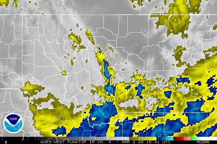
Visible Satellite |
Infrared Satellite Click to Enlarge |
Water Vapor Satellite Click to Enlarge |


 Great Falls Radar
 Satellite
 Current Observations
 Forecast Discussion
 Montana Weather
 Fire Weather
 Winter Weather Forecasts
 Transportation Forecasts
 Weather Prediction Center
 Storm Prediction Center
 Aviation Weather