The NWS in Great Falls is changing public forecast and warning zone boundaries to improve the accuracy of watch, warning and advisory products - Effective September 13, 2022.
These changes are intended to provide increased flexibility and improved accuracy of forecast, watch, warning, and advisory products in the public weather program. Twenty current zones will be converted into 30 new zones. These new zones are being created primarily to optimize issuance of public forecast and hazard products for conditions that can vary significantly across the highly variable terrain of this region.
Note: Fire Weather zone configurations will not be changing.
The current configuration of public forecast and warning zone boundaries (Figure 1) was developed in the 1990s and generally follows county boundaries with the exception of the two zones along the Rocky Mountain Front.

Figure 1: Current zone boundaries across north-central and southwest Montana
New Zone Configuration
The map below show our new configuration of forecast/warning zones (Figure 2). These zones were created to better differentiate mountain/terrain based weather hazards while also maintaining county boundaries were possible. The goal is to provide better geographic definition to weather hazards considering local climate, topography, population and major travel routes, while also considering available observational data.
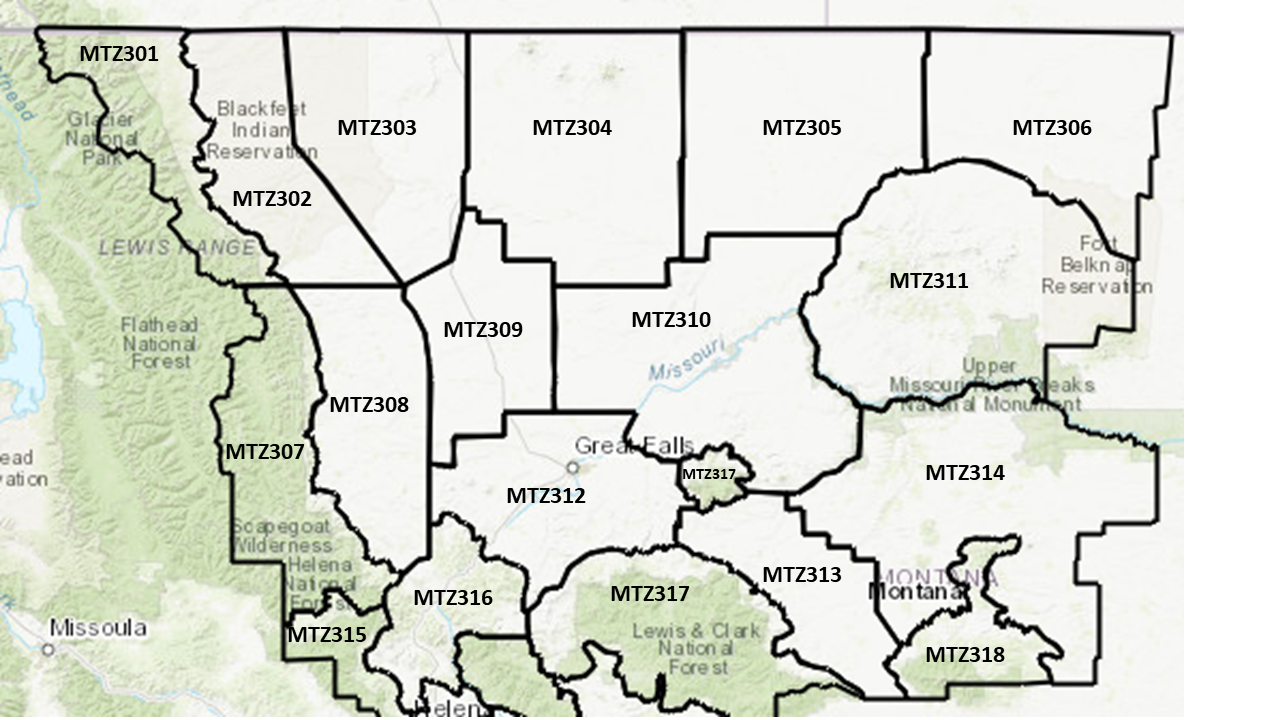
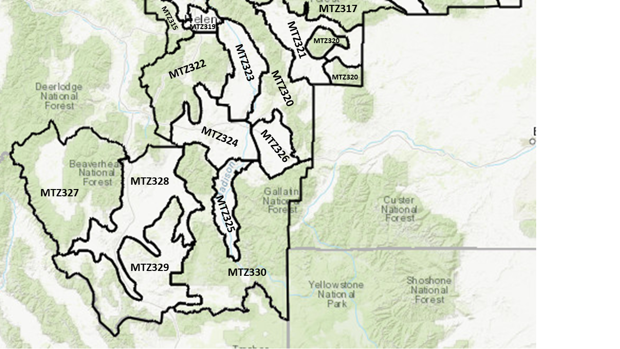
Figure 2: New zone boundaries for north-central and southwest Montana.
Complex Topography and Climate
The NWS Great Falls forecast areas has a very complex combination of terrain ranging from Plains and River breaks across north-central and northeast parts of the forecast area with island mountain ranges interspersed to Mountain Ranges and Valleys across western and southwest parts of the forecast area. Elevations range from as low as 2300 ft. along the Milk and Missouri River bottoms in eastern Blaine and Fergus counties to mountain peaks over 11000 ft. in the Madison Range (Figure 3). This results in a wide variety of land uses ranging from crop and rangeland at lower elevations to forest and recreation at higher elevations (Figure 4).

Figure 3: New zone boundaries elevation and roads.

Figure 4: New zone boundaries with land use.
The varied and complex topography creates large differences in weather regimes across the area with affects to precipitation, temperature and wind. Below is a map of average annual precipitation and the proposed zone configuration (Figure 5).
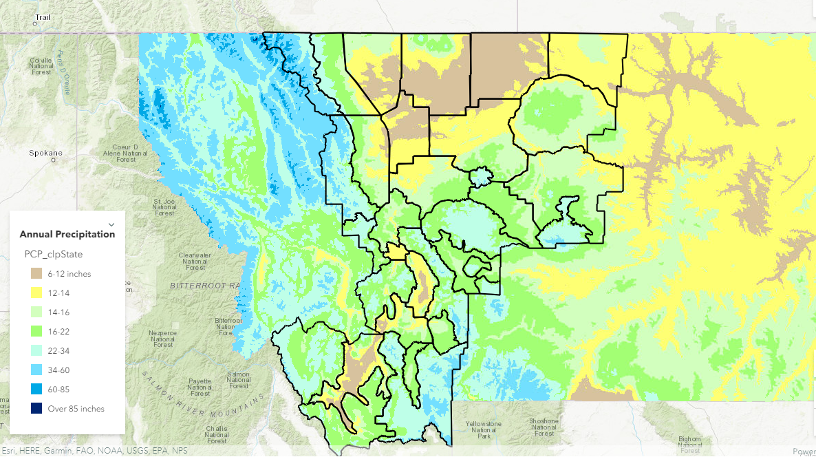
Figure 5: New zones with annual precipitation.
Population is concentrated at lower elevations across the plains of north-central Montana and in the valleys of southwest Montana (Figure 6). The Helena and Gallatin valleys are major population centers surrounded by mountains where weather changes rapidly over a short distance.

Figure 6: New zones with population density.
Travel and transportation occurs across many Federal and State highways across the area (Figure 7). Winter and wind related weather hazards occur at all elevations and these new zones will support a more targeted communication of hazards.

Figure 7: New zones with US and State Highways.


 Great Falls Radar
 Satellite
 Current Observations
 Forecast Discussion
 Montana Weather
 Fire Weather
 Winter Weather Forecasts
 Transportation Forecasts
 Weather Prediction Center
 Storm Prediction Center
 Aviation Weather