National Weather Service United States Department of Commerce

Powerful Pacific System Impacting the West; First Significant Snow for Portions of the East

Power Pacific system will continue to bring significant impacts for Pacific Northwest into northern California the remainder of the week. Dangerous coastal affects, heavy rain, flooding, strong winds, and higher elevation mountain snow continues. Meanwhile, a storm across the east is set to bring the first accumulating snow to many higher elevations of the Catskills into the central Appalachians. Read More >


What Does El Niño Mean for Northern California?

What is El Niño?

 
The El Niño Southern Oscillation (ENSO) is made up of both El Niño and La Niña and are periodic departures from expected sea surface temperatures near the equator in the Pacific Ocean. These warmer or cooler than normal ocean temperatures can affect weather patterns around the world by influencing high and low pressure systems, wind, and precipitation. El Niños occur irregularly, approximately every 2 to 7 years. There are three phases to this single climate phenomenon:
 
  • El Niño:  A warming of the ocean surface, or above-average sea surface temperatures (SST), in the central and eastern tropical Pacific Ocean.  Over Indonesia, rainfall tends to become reduced while rainfall increases over the tropical Pacific Ocean.  The low-level surface winds, which normally blow from east to west along the equator (“easterly winds”), instead weaken or, in some cases, start blowing the other direction (from west to east or “westerly winds”).
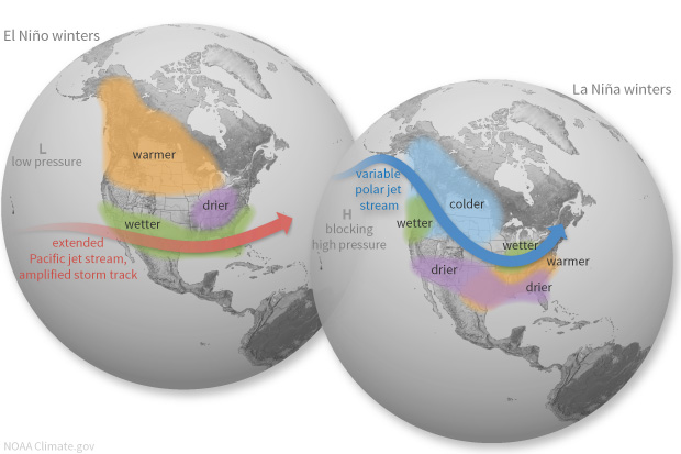
  • La Niña:A cooling of the ocean surface, or below-average sea surface temperatures (SST), in the central and eastern tropical Pacific Ocean.  Over Indonesia, rainfall tends to increase while rainfall decreases over the central tropical Pacific Ocean.  The normal easterly winds along the equator become even stronger.
  • Neutral:Neither El Niño or La Niña. Often tropical Pacific SSTs are generally close to average.  However, there are some instances when the ocean can look like it is in an El Niño or La Niña state, but the atmosphere is not playing along (or vice versa). (credit: climate.gov)


How does El Niño affect Northern California?

 
In Northern California, there is little correlation between precipitation and most ENSO patterns. Southern California is generally much more impacted with El Nino conditions bringing higher than normal precipitation and La Nina bringing below normal precipitation to Southern California. 
 
​
 
It is important to keep in mind that most of California's major reservoirs reside across the northern and central parts of the state. For drought relief, it is critical that these area receive significant rain and snow through the winter. While there is a possibility that we could see significant rain and snow, it is not a certain outcome.
 

What is the current ENSO status?

https://www.climate.gov/enso

https://psl.noaa.gov/map/clim/sst.anom.anim.year.htm


Northern Sierra Precipitation (8-station Index in Sacramento Basin)

Central Sierra Precipitation (5-station Index in San Joaquin Basin)

Southern Sierra Precipitation (6-station Index in Tulare Basin)