|
||
|
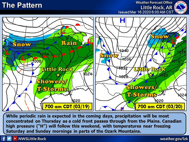
By mid-March, with severe weather season in full swing, there had yet to be any tornadoes during the month. Our string of good luck was about to change on the 19th as another cold front barreled into the area. |
||
|
||
|
By mid-March, with severe weather season in full swing, there had yet to be any tornadoes during the month. Our string of good luck was about to change on the 19th as another cold front barreled into the area. |
||
|
||
|
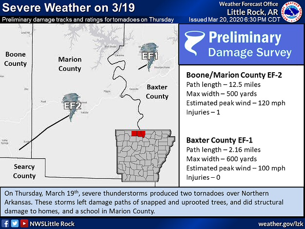
A line of strong to severe storms developed ahead of the front, with the most robust storms closest to the Missouri border after 600 pm CDT. One storm in particular went from southeast Boone County into southern Marion County and northwest Baxter County. |
||
|
||
|
The storm had strong rotation at times and it headed quickly to the northeast at 40 to 50 mph. There was plenty of chaos in the path of the storm, and no doubt that one or more tornadoes were in play. |
||
|
|||
|
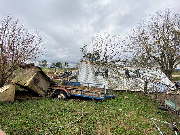
A house was damaged east of Everton (Boone County), and power lines were downed. Between Pyatt and Bruno (both in Marion County), several homes were damaged or destroyed with an injury reported. A school was also affected. A tree fell through a house west of Mountain Home (Baxter County). In the end, two tornadoes (rated EF1/EF2) were spawned in a three county area. Three more weak tornadoes (all rated EF1) were confirmed with separate storms from five miles north of Hector (Pope County) to six miles west-southwest of Rupert (Van Buren County), and from four miles northeast of Evening Shade to four miles north of Poughkeepsie (both in Sharp County). These tornadoes toppled trees and hit a couple of barns and outbuildings. |
|||
| Link of Interest |
| Damage Survey Information |
|
||
|
This event did not feature a lot of rain, and there was only 0.01 inch measured at Little Rock (Pulaski County) on the 19th. But, this was enough to make it eleven consecutive days with measurable precipitation. It was one day away from tying the all-time record of twelve days in a row. A trace of rain on the 20th ended the streak. |
||
|
||
|
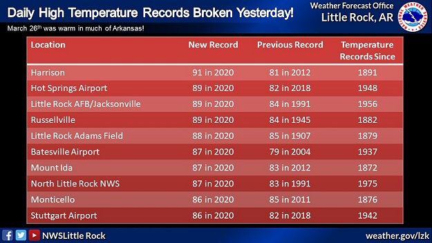
Toward the end of March, it started feeling like summer on the 26th. A warm front exited to the north of the state, and ushered in well above average temperatures in the 80s to lower 90s. The high of 91 degrees at Harrison (Boone County) shattered the previous daily record of 81 degrees set in 2012. At Little Rock (Pulaski County), the mercury hit 88 degrees. It had not been this toasty since 1907 on this day when it was 85 degrees. It is days like this that pushed monthly temperatures well above normal. Average temperatures in March were four to eight degrees warmer than usual. |
||
| Average Temperatures in March, 2020 | ||
| Site | Avg Temp | +/- |
| Fayetteville (NW AR) | 56.1° | +8.0° |
| Harrison (NC AR) | 54.3° | +5.5° |
| Jonesboro (NE AR) | 54.9° | +4.7° |
| Fort Smith (WC AR) | 58.6° | +5.6° |
| Little Rock (C AR) | 57.2° | +3.8° |
| West Memphis (EC AR) | 57.2° | +5.7° |
| Texarkana (SW AR) | 61.1° | +5.1° |
| El Dorado (SC AR) | 61.9° | +6.1° |
| Pine Bluff (SE AR) | 58.3° | +3.9° |
|
||
|
It was still very mild on the 28th, and there was at least some potential of tornadoes (although tornadoes were most likely from Iowa to Illinois and Indiana). Precipitation behaved for the bulk of the day (not much happening). A large area of showers crossed Arkansas during the afternoon, and there were rumbles of thunder at times. But as rain headed into eastern sections of the state, things got interesting. Rotation picked up in one storm near Tupelo (Jackson County), and a Tornado Warning was issued at 359 pm CDT. About twenty minutes later, there were reports of roofs off of homes between Algoa and Amagon (both in Jackson County). Farm equipment storage buildings were dismantled, and trees were uprooted. A tornado was to blame, and was given a rating of EF1 (110 mph winds) by the National Weather Service in Little Rock (Pulaski County). The tornado dissipated close to the Poinsett County line (a path length of just over five miles). |
||
|
||
|
Rotation weakened temporarily, but cranked up again (30 miles to the northeast) as the storm arrived on the south/east side of Jonesboro (Craighead County) shortly before 500 pm CDT. Numerous homes and businesses (including a mall) were heavily damaged or destroyed, and cars were tossed like toys. Hangers and planes were ripped up at the airport, and a 74 mph gust was measured by observing equipment. Just north of the airport, a train was derailed. At least twenty people were injured, but there were no casualties. Due to the coronavirus pandemic, there was not much going on around town. Stores were either closed or experiencing much lighter than normal traffic. According to officials, areas that were affected by the tornado would have been crowded, and this situation (from a fatality/injury standpoint) could have been much worse. |
||
|
||
|
The nightmare did not end at Jonesboro (Craighead County). The storm traveled through Brookland (Craighead County) and just east of Paragould (Greene County), and caused more mayhem. A damage survey by the National Weather Service in Memphis, TN confirmed an EF3 tornado (140 mph winds) at Jonesboro (Craighead County). This was the strongest tornado in the state since the EF4 monster twister that pummeled Mayflower and Vilonia (both in Faulkner County) on April 27, 2014. A separate tornado (rated EF1) was identified in southeast Greene County (a total of three tornadoes during the event). |
||
| Link of Interest |
| Jonesboro (Craighead County) Damage Photos (courtesy of the Jonesboro Police Department via Facebook) |