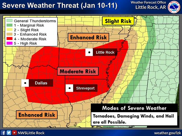
There was an enhanced to moderate risk of severe weather in the twenty four hour period ending at 600 am CST on 01/11/2020. The forecast is courtesy of the Storm Prediction Center.
In the picture: There was an enhanced to moderate risk of severe weather in the twenty four hour period ending at 600 am CST on 01/11/2020. The forecast is courtesy of the Storm Prediction Center.
 

January started off with a bang on the 10th. It felt like spring in Arkansas, with high temperatures in the 60s to lower 70s. As the day began, a powerful storm system was looming to the west in New Mexico. Moisture levels were on the rise ahead of the system. It was a perfect setup for severe weather and flash flooding.

By late afternoon and into the overnight hours/early on the 11th, a massive damaging wind episode unfolded. Wind gusts from 60 to 90 mph pounded parts of the state. Trees and/or power lines were downed at Yellville (Marion County), Henderson (Baxter County), Elizabeth (Fulton County), Melbourne (Izard County), Leslie (Searcy County), a few miles west of Arkadelphia (Clark County), Malvern (Hot Spring County), Judsonia (White County), Fordyce (Dallas County), Pine Bluff (Jefferson County), Cotton Plant (Woodruff County), Joiner (Mississippi County), Monticello (Drew County), St. Charles (Arkansas County), and Watson (Desha County). Some fallen trees landed on homes. Seven tractor trailers were blown over on Interstate 40 just east of Wheatley (St. Francis County). Wind recording equipment measured a 74 mph gust at Fargo (Monroe County), and a 71 mph gust at the University of Arkansas at Monticello (Drew County).

Preceding the event, the Storm Prediction Center in Norman, OK called for a moderate risk of severe weather over the southern half of Arkansas, and an enhanced risk farther north.


Link of Interest
Help with Severe Weather Categories


When risk levels are this high (which is rare), an outbreak of severe storms is usually the result. The National Weather Service in Little Rock (Pulaski County) tried to draw attention to the magnitude of the situation by using wording such as "hurricane force winds" and "this is serious" in its messaging to the public.


A Rare Moderate Risk

On January 9th, the Storm Prediction Center (SPC) in Norman OK had a moderate risk of severe weather in far southwest Arkansas, northeast Texas, and northwest Louisiana on the 10th (a Day 2 forecast). This was only the fourth time a Day 2 moderate risk was issued in January, and the first time in six years. The moderate risk area was expanded markedly the next day (a Day 1 forecast). This information is from Dr. Patrick Marsh of SPC (via Twitter).


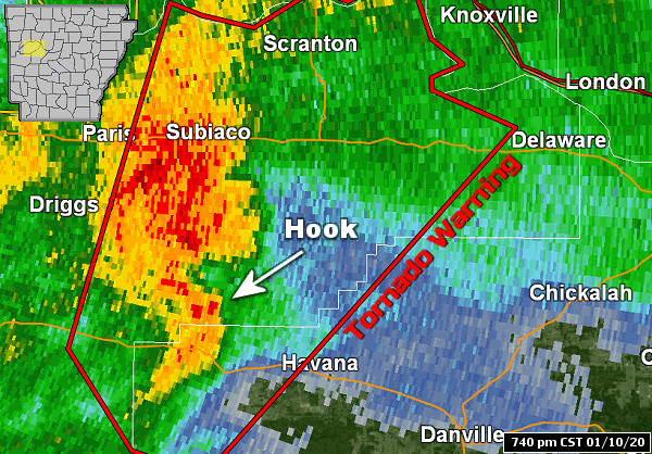
A supercell (storm with rotating updrafts and exhibiting features such as a hook echo and strong rotation) was south of Subiaco (Logan County) at 740 pm CST on 01/10/2020. The supercell preceded a line of storms building into western Arkansas from Oklahoma.
Reflectivity at 740 pm CST (01/10)  |  Storm Relative Velocity at 740 pm CST (01/10)
More About Rotation
In the pictures: A supercell (storm with rotating updrafts and exhibiting features such as a hook echo and strong rotation) was south of Subiaco (Logan County) at 740 pm CST on 01/10/2020. The supercell preceded a line of storms building into western Arkansas from Oklahoma. 
 

In addition to all of the wind, there were also isolated tornadoes. At 740 pm CST on the 10th, a tornado (rated EF2) was spawned southwest of Midway (Logan County). The tornado cut close to a fourteen mile path before dissipating northeast of Scranton (Logan County).


Link of Interest
Video of Tornado Damage in Logan County (courtesy of Brian Emfinger via Twitter)


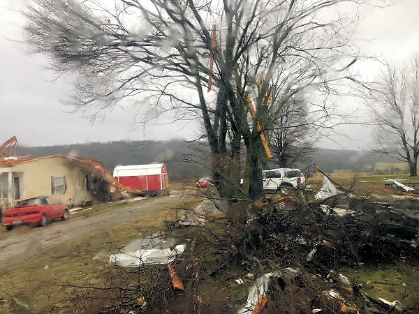
Several tornadoes (rated EF1/EF2) damaged or destroyed structures north and east of Midway and Scranton (both in Logan County), near Seaton (Lonoke County), and around Jerome (Drew County) from the evening of 01/10/2020 through the wee hours of the next morning.
Home and Surroundings in Disarray North of Midway (Logan County)
Inside of Home Missing Roof North of Midway (Logan County)
Outbuildings Destroyed East of Scranton (Logan County)
Storage Shed Thrown Into Trees and Destroyed Near Seaton (Lonoke County)
Silo Mangled Near Jerome (Drew County)
In the pictures: Several tornadoes (rated EF1/EF2) damaged or destroyed structures north and east of Midway and Scranton (both in Logan County), near Seaton (Lonoke County), and around Jerome (Drew County) from the evening of 01/10/2020 through the wee hours of the next morning.
 

Nine other mostly weak tornadoes (eight rated EF1/one rated EF2) were confirmed across the state through the wee hours of the 11th. Two of these tornadoes were in the Little Rock County Warning Area near Seaton (Lonoke County) and Jerome (Drew County). The former tornado blew in a grain bin and tossed a shed into nearby trees. The latter tornado mangled a silo. Trees were uprooted or snapped, and utility poles were taken out.


Link of Interest
Damage Survey Information


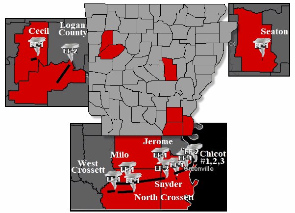
Eleven tornadoes (rated EF1/EF2) were counted across Arkansas on January 10-11, 2020.
In the picture: Eleven tornadoes (rated EF1/EF2) were counted across Arkansas on January 10-11, 2020.
 

Similar damage was noted with a tornado in the Tulsa County Warning Area three to four miles east-southeast of Cecil (Franklin County). Seven tornadoes were counted in the Jackson County Warning Area from West Crossett to Hamburg and Montrose (all in Ashley County) eastward to Lake Village (Chicot County) and on into western Mississippi. Damage was a little more substantial, with a handful of mobile homes dismantled, roofs torn up on homes and a couple of churches, and a metal high tension electric line yanked to the ground. At least two injuries were reported.


Giant Pine Tree in Arkansas Gone

The Morris Pine was around for at least three centuries in the Levi Wilcoxon Demonstration Forest south of Hamburg (Ashley County). This was regarded as one of the largest and oldest pine trees in Arkansas. Sadly, the tree did not make it through the storm early on the 11th. A tornado (rated EF1) was the culprit.


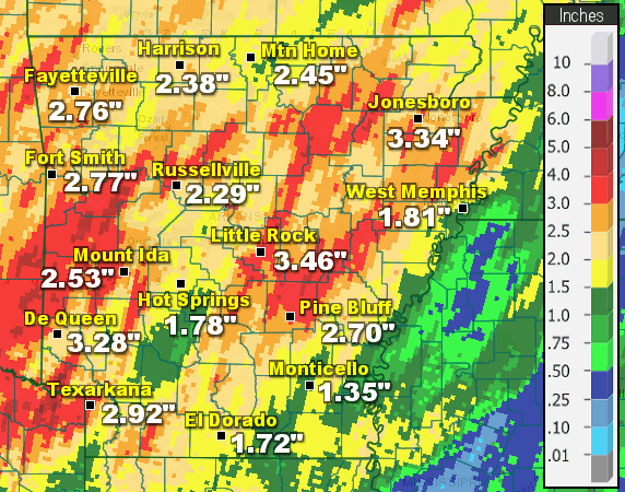
Twenty four hour rainfall through 600 am CST on 01/11/2020. Amounts exceeded four inches in places.
Rain in Arkansas  |  Rain Across the Region
In the pictures: Twenty four hour rainfall through 600 am CST on 01/11/2020. Amounts exceeded four inches in places.
 

There was torrential rain. More than four inches of precipitation dumped in spots. Twenty four hour totals through 600 am CST on the 11th included 5.00 inches at Batesville (Independence County), 4.30 inches at Bogg Springs (Polk County), 4.20 inches at Waldron (Scott County), 4.05 inches at Sparkman (Dallas County), 3.90 inches at Parks (Scott County) and Subiaco (Logan County), 3.83 inches at Cabot (Lonoke County), 3.78 inches at Booneville (Logan County), 3.75 inches at Big Fork (Polk County), 3.59 inches at Calamine (Sharp County), 3.52 inches at Pine Ridge (Montgomery County), 3.50 inches at Newport (Jackson County), and 3.46 inches at Little Rock (Pulaski County).


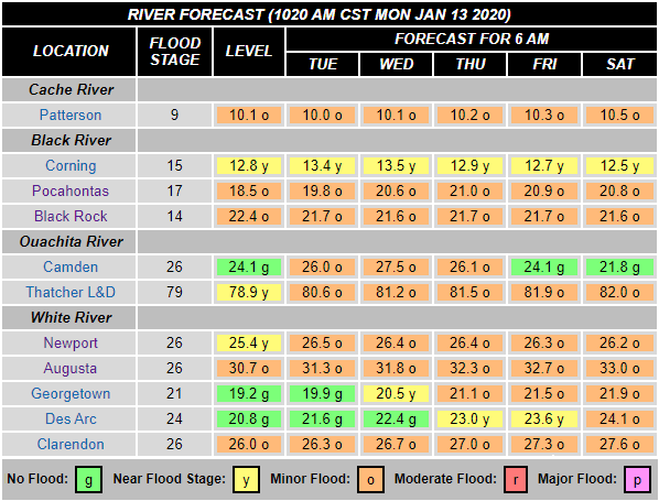
There was minor flooding along the Black, Cache, Ouachita, and lower White Rivers on 01/13/2020.
In the picture: There was minor flooding along the Black, Cache, Ouachita, and lower White Rivers on 01/13/2020.
 

Because vegetation was dormant and consuming little ground water, runoff rates were high and rivers responded by going up. Minor flooding resulted on a number of tributaries including the Black, Cache, Eleven Point, Fourche LaFave, Ouachita, Petit Jean, Spring, and White Rivers. The same was true on the Arkansas River west of Dardanelle (Yell County). 


In the picture: Some snow accumulated on Mount Magazine (Logan County) on 01/22/2020 at an elevation of just over 2300 feet. The photo is courtesy of Jesse Hays via Twitter.
 

After the severe weather and heavy rain were over, it turned colder. A large dome of Arctic high pressure settled over areas east of the Mississippi River. High temperatures by the 21st were only in the mid 30s to mid 40s (well below normal highs in the mid 40s to mid 50s). As cold air became entrenched across the region, a storm system headed this way from the southern Plains. Ahead of the system, wintry precipitation developed. On the 22nd, a band of light snow and sleet in western Arkansas produced a quick one to two inches of accumulation at Fort Smith (Sebastian County) and Van Buren (Crawford County), and a half inch to an inch at Bentonville (Benton County), Bogg Springs (Polk County), and Queen Wilhelmina State Park (Polk County).

By 1200 pm CST on the 22nd, there was less concern about wintry precipitation as temperatures climbed above freezing. But all was not well in the higher elevations of the Ozark and Ouachita Mountains of the north and west. A balloon launch from North Little Rock (Pulaski County) at 600 pm CST showed a layer of subfreezing air not far above the ground and extending to around 3000 feet.


North Little Rock (Pulaski County) at 600 pm CST on January 22, 2020
Elevation Temperature (deg F)
570 feet (Ground) 33°
2000 feet 27°
3000 feet 32°
4000 feet 33°
5000 feet 37°


An inversion (rising temperatures) existed farther aloft at 4000 and 5000 feet. Snow and sleet that fell through this layer tended to melt, and then froze in the subfreezing layer.


Link of Interest
The Setup For Ice Graphically


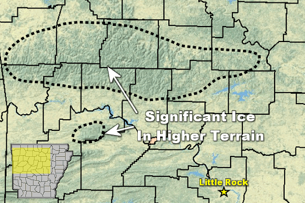
There was significant icing (a half inch or more in spots) in the higher elevations of northern and western Arkansas on 01/22/2020 and early the next morning.
In the picture: There was significant icing (a half inch or more in spots) in the higher elevations of northern and western Arkansas on 01/22/2020 and early the next morning.
 

During the evening of the 22nd, an ice storm was in progress. Photos showed some buildup on branches near Mountain Home (Baxter County), with at least a quarter of an inch of ice on exposed objects a few miles southwest of West Fork (Washington County). A check of temperatures at a few mountain locations at 400 am CST on the 23rd revealed a reading of 29 degrees at Jasper (Newton County), and 31 degrees at Alco (Stone County) and Compton (Newton County).


In the video: Parts of the Ozark Mountains experienced an ice storm as noted at Ozone (Johnson County) early on 01/23/2020. The video is courtesy of Brian Emfinger via Twitter.
 

In the end, more than a half inch of ice accrued on exposed objects in places such as Botkinburg (Van Buren County), Deer (Newton County), Moreland (Pope County), Mount Magazine (Logan County), Ozone (Johnson County), and Witts Spring (Searcy County). Ice was the most significant at elevations above 1500 feet. The weight of the ice downed numerous downed trees and caused hundreds of power outages.