River flooding was a huge problem in Arkansas and surrounding states on 05/04/2019.
In the picture: River flooding was a huge problem in Arkansas and surrounding states on 05/04/2019.
 

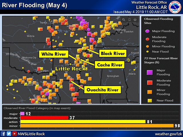
Heading into May, heavy to excessive rain left rivers high in the southern and eastern counties. This included the Black, Cache, Ouachita, and lower White Rivers. While these rivers created issues at times, such as flooding nearby fields and closing highways, it was far from the disaster yet to come along the Arkansas River.


Rainfall in May, 2019.
In the picture: Rainfall in May, 2019.
 

While it was a Top 10 wet May around here (a statewide average of nine inches/close to four inches above average), downpours were even more intense in southeast Kansas and northeast Oklahoma. Fifteen to more than twenty inches of precipitation fell in this part of the country.


Following heavy rain in Oklahoma, the water level on Keystone Lake was well above normal (more than twenty five feet too high) and was dangerously close to the flood pool on 05/22/2019. The graphic (edited) is courtesy of the U.S. Army Corps of Engineers, Tulsa District.
In the picture: Following heavy rain in Oklahoma, the water level on Keystone Lake was well above normal (more than twenty five feet too high) and was dangerously close to the flood pool on 05/22/2019. The graphic (edited) is courtesy of the U.S. Army Corps of Engineers, Tulsa District.
 

Lake levels became dangerously high, and water releases were necessary. Near Tulsa, OK, releases (greater than 250,000 cubic feet per second) at Keystone Dam were more than double the flow of Niagara Falls. The Arkansas River was about to go haywire. 


Record or near record crests occurred along the Arkansas River in late May and early June, 2019. At several forecast points, previous record crests were surpassed by more than two feet.
In the picture: Record or near record crests occurred along the Arkansas River in late May and early June, 2019. At several forecast points, previous record crests were surpassed by more than two feet.
 

In late May/early June, the river rose to unprecedented levels. Crests were more than two feet above previous high marks at Van Buren (Crawford County), Toad Suck (Perry County), and Pendleton (Desha County).


In the video: Water from the Arkansas River was flooding homes near Two Rivers Park about eight miles northwest of Little Rock (Pulaski County) on 05/29/2019. The video is courtesy of the Arkansas State Police.
 

Evacuations became necessary as homes and businesses flooded. Levees were breached, including one near Dardanelle (Yell County). The water was headed toward town, with 300 to 400 homes in danger of going under water.


Link of Interest
Video of Levee Breach Near Dardanelle (Yell County) Along the Arkansas River (courtesy of Brian Emfinger via Twitter)


In the pictures: City, county, and state government officials got together on 06/02/2019 to work on a solution to a levee breach near Dardanelle (Yell County). The information is courtesy of Mayor Richard Harris of Russellville (Pope County) via Twitter.
 

Sandbagging took place to protect property from rising water. In the end, the homes were spared, but farms and farmland in the area were heavily impacted. There was also major damage to Highway 155, which could take months to repair. There was a potential for many more homes to be impacted by overtopped levees from Little Rock (Pulaski County) to Pine Bluff (Jefferson County).


The path of the Arkansas River was clearly marked by flooded highways from west central through central and southeast Arkansas on 06/07/2019.
In the picture: The path of the Arkansas River was clearly marked by flooded highways from west central through central and southeast Arkansas on 06/07/2019. The graphic is courtesy of IDriveArkansas.
 

Numerous highways were closed and flooded. This included Highway 22 near Barling (Sebastian County), which did not open until water receded on the 4th (after cresting on the 1st). A 64-year-old man lost his life on this highway on May 28th after driving around a barricade.


In the picture: A Flood Warning was issued for Lake Conway (Faulkner County) on 06/03/2019 as Palarm Creek backed up due to a record high Arkansas River.
 

There was also a lot happening around Conway (Faulkner County). On the 3rd, a Flood Warning was issued for Lake Conway as Palarm Creek backed up. People were advised to evacuate before water flowed into houses surrounding the lake a couple of days later.


In the picture: The Lollie Levee near Conway (Faulkner County) held its ground on 06/07/2019 against a record high Arkansas River. The information is courtesy of the City of Conway via Twitter.
 

Meanwhile, there were images of Lollie Levee eroding, and it appeared that failure was imminent. This put parts of Conway (Faulkner County) in danger of flooding. There were more evacuations, and the situation was monitored closely. By the 7th, it became clear that the levee would hold. The levee was presented a key to the city on the 10th.