In the video: The satellite loop showed a mesoscale convective vortex (MCV) triggering thunderstorms from central into northeast Arkansas during the afternoon of 05/02/2019. The MCV came from decaying thunderstorms in the southern Plains the night before.
 

Up to this point, while it was raining a lot, there were only a half dozen mostly weak tornadoes through April. Severe weather tended to dodge the area to the south/east. On May 2nd, a somewhat odd situation led to one of the most rapidly unfolding situations of 2019.

A dissipating cluster of thunderstorms in the southern Plains left behind a mesoscale convective vortex (MCV). At times, this feature has been known to trigger new storms downstream from the storms that decayed. Also, the turning motion of the MCV can enhance rotation within developing storms. The problem with MCVs is they are not created equal. If is difficult to know what exactly each will bring.

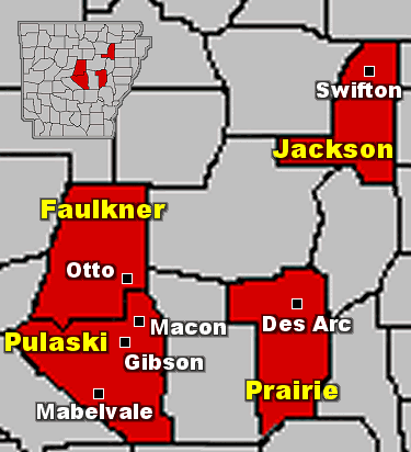
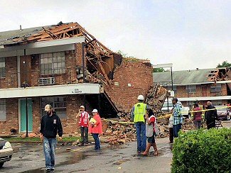
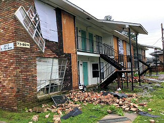
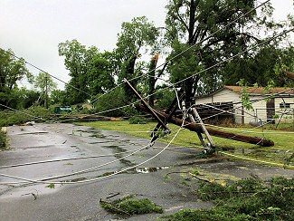
In this case, the MCV help spark several brief and weak tornadoes (rated EF0/EF1) from central into eastern Arkansas. At least seven tornadoes were confirmed in the Little Rock County Warning Area.


In the pictures: A weak tornado (rated EF1) damaged structures and overturned trucks near Mabelvale (Pulaski County) on 05/02/2019. The photos are courtesy of Brian Emfinger via Twitter.
 

The first of these tornadoes hit Mabelvale (Pulaski County) shortly after 1230 pm CDT, and was gone in four minutes. Within the next hour, four more short-lived tornadoes spun up near Gibson, to the northeast and west of Macon (all in Pulaski County), and just southwest of Otto (Faulkner County). Between 200 pm and 300 pm CDT, areas just southeast of Swifton (Jackson County) and west of Des Arc (Prairie County) had tornadoes.

Damage was minor overall, and consisted of downed or snapped trees and power poles. Affected structures either lost roofing material or had trees come down on them. Some roads were blocked by debris, and a few eighteen wheelers were overturned.


At least four weak tornadoes (rated EF0/EF1) were confirmed near Mabelvale, Gibson, and northeast of Macon (all in Pulaski County), and also close to Swifton (Jackson County) on 05/02/2019. There were also tornadoes northeast of Lafe (Greene County) and north of Gosnell (Mississippi County) in the Memphis County Warning Area. It was thought a tornado was responsible for damage to a baseball field in McCrory (Woodruff County). A damage survey found evidence of a thunderstorm microburst (straight-line winds).
In the picture: At least four weak tornadoes (rated EF0/EF1) were confirmed near Mabelvale, Gibson, and northeast of Macon (all in Pulaski County), and also close to Swifton (Jackson County) on 05/02/2019.


Link of Interest
Damage Survey Information (May 2)


Too much rain flooded Batesville Pike near Jacksonville-Conway Road just northwest of Macon (Pulaski County) on 05/02/2019. It was the same story along Race Street in Searcy (White County) and Central Avenue in Hot Springs (Garland County). The photos are courtesy of John Robinson, Robert Rowland, and the Hot Springs Police Department.
Flooding on Batesville Pike Near Macon (Pulaski County)
Flooding on Race Street in Searcy (White County)
Flooding on Central Avenue in Hot Springs (Garland County)
In the pictures: Too much rain flooded Batesville Pike near Jacksonville-Conway Road just northwest of Macon (Pulaski County) on 05/02/2019. It was the same story along Race Street in Searcy (White County) and Central Avenue in Hot Springs (Garland County). The photos are courtesy of John Robinson, Robert Rowland, and the Hot Springs Police Department.
 

Because of the MCV (which boosted rainfall rates), flash flooding became an issue in central Arkansas. A quick two inch deluge at Hot Springs (Garland County) during the morning of the 2nd flooded Central Avenue. Photos showed cars halfway submerged in water. Too much rain in North Little Rock (Pulaski County) led to high water and numerous roads closed. There was also flooding in Searcy (White County).


Damage found on the east side of Pine Bluff (Jefferson County) was in a convergent pattern, which suggested a weak tornado (rated EF1) was responsible on 05/08/2019.
In the picture: Damage found on the east side of Pine Bluff (Jefferson County) was in a convergent pattern, which suggested a weak tornado (rated EF1) was responsible on 05/08/2019.
 

One of the more publisized tornadoes of the year happened at 619 pm CDT on the 8th. This was a high end weak tornado (rated EF1) that was spawned on the east side of Pine Bluff (Jefferson County) near some apartment buildings. The tornado only lasted a quarter of a mile, but produced 110 mph winds.


Following a high end weak tornado (rated EF1), the wall of an apartment collapsed with with interior rooms exposed on the east side of Pine Bluff (Jefferson County) on 05/08/2019.
In the picture: Following a high end weak tornado (rated EF1), the wall of an apartment collapsed with with interior rooms exposed on the east side of Pine Bluff (Jefferson County) on 05/08/2019. Click to enlarge.
The same tornado ripped another wall apart on a different apartment building on 05/08/2019.
In the picture: The same tornado ripped another wall apart on a different apartment building on 05/08/2019. Click to enlarge.
In the same area, bricks were removed from this building and windows were blown out on 05/08/2019.
In the picture: In the same area, bricks were removed from this building and windows were blown out on 05/08/2019.  Click to enlarge.
Trees and utility poles were also snapped on 05/08/2019.
In the picture: Trees and utility poles were also snapped on 05/08/2019. Click to enlarge.
 

The apartment buildings were heavily damaged, with a couple of walls partially or mostly exposed. Nine people were injured, and seventy families were displaced. The Red Cross declared this a major disaster.


Link of Interest
Damage Survey Information (May 8)