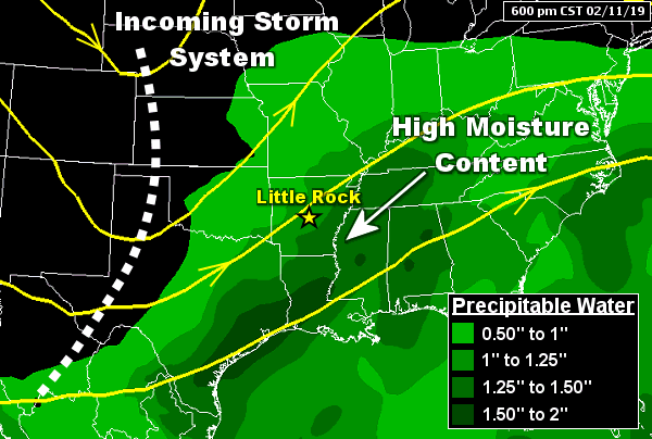
There was abundant moisture in Arkansas ahead of an incoming storm system at 600 pm CST on 02/11/2019. Precipitable water (PWAT), or water vapor contained in a vertical column of the atmosphere, was more than double the average. Values were as high as 1.35 inches at the North Little Rock Airport (Pulaski County) earlier in the day. Typically in mid-February, values are between 0.50 inch and 0.75 inch.
In the picture: There was abundant moisture in Arkansas ahead of an incoming storm system at 600 pm CST on 02/11/2019. Precipitable water (PWAT), or water vapor contained in a vertical column of the atmosphere, was more than double the average. Values were as high as 1.35 inches at the North Little Rock Airport (Pulaski County) earlier in the day. Typically in mid-February, values are between 0.50 inch and 0.75 inch.
 

It was a perfect setup for flooding heading into mid-February. The ground was wet (and could not hold much additional water) following six straight months of above average precipitation. Rivers were running high. The atmosphere was loaded with moisture on the 10th/11th, and a storm system in the Plains was set to wring it out of the clouds. It was a bad situation.


Link of Interest
Typical Precipitable Water Values at Little Rock (Pulaski County)


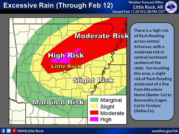
There was a moderate to high risk of flash flooding from central into northeast Arkansas on 02/11/2019.
In the picture: There was a moderate to high risk of flash flooding from central into northeast Arkansas on 02/11/2019.
 

The forecast called for several inches of rain from central into northeast Arkansas. Rain focused along and north of a front that was stalled over southeast sections of the state.


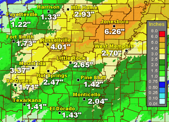
Seventy two hour precipitation through 600 am CST on 02/12/2019.
In the picture: Seventy two hour precipitation through 600 am CST on 02/12/2019.
 

By the time the event was over, more than half a foot of liquid was measured in places. Seventy two hour precipitation totals through 600 am CST on the 12th included 6.26 inches at Jonesboro (Craighead County), 6.02 inches at Newport (Jackson County), 5.18 inches at Blytheville (Mississippi County), 5.10 inches at Walnut Ridge (Lawrence County), 4.61 inches at Batesville (Independence County), 4.03 inches at North Little Rock (Pulaski County), and 4.01 inches at Russellville (Pope County).

These amounts exceeded what would normally fall from the sky in all of February. For the month, much of the eastern half of the state received over ten inches of rain, including 11.95 inches at West Memphis (Crittenden County) and 11.25 inches at Jonesboro (Craighead County).


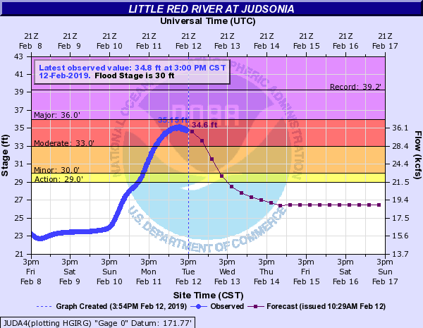
The hydrograph for the Little Red River at Judsonia (White County) showed a crest of 35.2 feet at 1015 am CST on 02/12/2019. This was well above the flood stage of 30 feet.
In the picture: The hydrograph for the Little Red River at Judsonia (White County) showed a crest of 35.2 feet at 1015 am CST on 02/12/2019. This was well above the flood stage of 30 feet.
 

The rain was too much for rivers in eastern Arkansas. There was major flooding along portions of the Cache River (water threatening homes, and roads and farmland under water in Jackson and Woodruff Counties). Moderate to major flooding was noted along stretches of the Black and lower White Rivers.

At Newport (Jackson County), the White River topped out just over 30 feet on the 14th. At this level (four feet above the flood stage of 26 feet), major flooding is expected. Just south of town, an eroding levee was in danger of failing. An emergency was declared on the 12th, and people near the levee were advised to evacuate (voluntarily). As a precaution, sandbags were made available to local residents. The levee was stabilized with sandbags as well.

There was also moderate flooding along the somewhat flashy (rapid rises and falls) Little Red River at Judsonia (White County). The river crested roughly five feet above the flood stage during the morning of the 12th.


In the video: The Little Red River was overflowing in and around Judsonia (White County) on 02/12/2019. Nearby roads and fields were under water. The video is courtesy of Charles Peek.
 

Drone footage from Judsonia (White County) showed the impacts of the overflowing river. It looked more like a lake than a river in places, with roads inundated with water and barricaded in some cases.

Swollen rivers closed highways in the northeast, including Highway 37 between Cord (Independence County) and Tuckerman (Jackson County), Highway 14 between Oil Trough (Independence County) and Newport (Jackson County), Highway 37 near Grubbs (Jackson County), Highway 25 between Black Rock and Powhattan (both in Lawrence County), and Highway 166 northeast of Pocahontas (Randolph County).

There were numerous reports of flash flooding. At least two vehicles were swept off the pavement by rapidly rising creeks. The vehicles were just east of Springfield (Conway County) near Cadron Creek, and west of Hagarville (Johnson County) at the intersection of Highways 123 and 292 close to Minnow Creek. No injuries were reported in either incident. 

On the 22nd, a 76-year-old man drove through high water along Highway 37 along the Black River. He went around at least four barricades to attempt to make a delivery in Batesville (Independence County). His body was discovered the next morning.