
Thunderstorms will continue to bring heavy to excessive rain and possible flooding over the middle and lower Texas Gulf Coast into tonight. Strong to severe thunderstorms are expected over south Texas and the lower Missouri/mid-Mississippi Valleys today. A storm will continue to bring gusty winds, hazardous seas, low elevation rain, and mountain snow to the Pacific Northwest through Friday. Read More >
|
Synoptic Overview
|
|
Roughly two weeks after Tropical Storm Isaias affected the northeast Caribbean islands, a vigorous tropical wave emerged from the west coast of Africa. On August 16th, the National Hurricane Center (NHC) increased the 5-day probability of tropical cyclone formation to medium (60 % percent) when the wave was south of the Cape Verde Islands. The tropical wave continued to move westward at 15 to 20 mph during the next day or two. When the wave and its associated low pressure approached Longitude 35W, it became better organized, showing some banding features near the center between August 17th and 18th. As a result, NHC boosted the probability of formation to 70% in 2-days and 90% in 5-days. However, the drier air ahead of the low pressure and lack of organization of the showers and thunderstorms, delayed the process of formation for more than 48 hours. Finally on Thursday August 20th, the low pressure system consolidated and became Tropical Depression Thirteen approximately 800 miles east of the Windward Islands.
Figure 1: Tropical Weather Outlook on Saturday July 25, 2020 at 2 PM AST, showing the disturbance near 35 West. By mid morning of Friday, NHC upgraded the depression into tropical storm Laura when the NOAA Hurricane Hunter aircraft found maximum winds of 45 mph near the center of the system. The data from the plane provided critical information about the center of Tropical Storm Laura, leading to hurricane specialists at NHC to reposition the center about 90 miles to the southwest. This change altered significantly the track forecast for the U.S. Virgin Islands and Puerto Rico. The previous advisory (#6A) put the system about 100 miles north of Puerto Rico while the advisory #7 forecasted the center passing over the U.S. Virgin Island and Puerto Rico. Laura continued moving mainly to the west as the center was passing near Montserrat and Antigua/Barbuda on Friday night.
By mid-morning of Saturday Aug 22th, the center of Tropical Storm Laura was located about 10 miles south of Guayanilla. While the storm was moving at 18 mph, rainbands with strong gusty winds were affecting most of Puerto Rico, Culebra and Vieques. The heaviest rainfall was pushed inland by the strong southerly winds after the center passed, producing frequent periods of intense rainfall over the east and south sections of Puerto Rico. The strongest winds over Puerto Rico were reported when the center of the storm was moving near Cabo Rojo into the Mona Passage early that afternoon. Specifically in the Salinas and Guayama region, in southeast Puerto Rico, a small scale rotation (meso-vortex) moved inland producing significant damages to crops, as well as, to a few houses that lost their galvanized roof. Heavy rains continued across most of Puerto Rico into the evening hours, especially over the east and south portions of Puerto Rico where total rainfall accumulations ranged between 3 and 5 inches. The Tropical Storm Warning was cancelled for the USVI at 11 PM AST on Saturday 22th and for Puerto Rico at 2 AM AST on Sunday 23th. |
Presione aquí para retornar a la página principal del Servicio Nacional de Meteorología
|
Satellite & Radar Imagery
|

Figure 2: Animated image of GOES-East on August 22, 2020. Image credit NOAA.
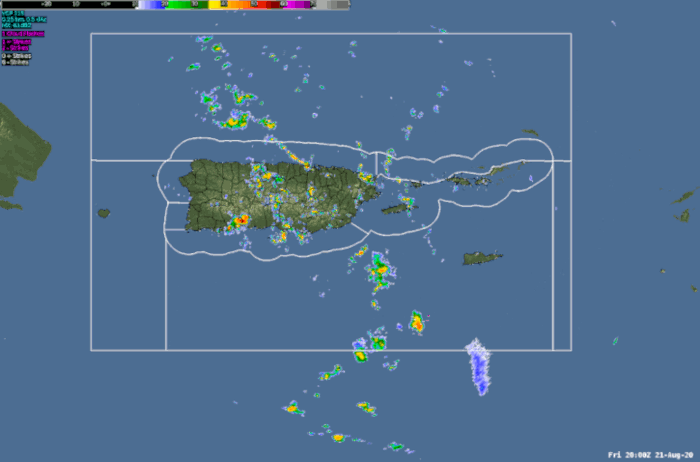
Figure 3: Loop of the TJUA NEXRAD doppler radar as Tropical Storm Laura moves across the local area.

Figure 4: ATSCAT (Scatterometer) measured the ocean surface wind field when Laura was near Puerto Rico on August 22th.
Presione aquí para retornar a la página principal del Servicio Nacional de Meteorología
|
Total Rainfall Accumulation
|

Figure 5: Total rainfall accumulation associated with Tropical Storm Laura.
|
Maximum Wind Gusts Reports
|

Table 1: Maximum Wind Gusts measured during the passage of Tropical Storm Laura.
|
Marine Observations
|


|
Damages
|
Puerto RicoRain-bands with strong gusty winds moved across portions of Puerto Rico on Saturday morning. However, the strongest winds occurred when the center of the storm was moving over the Mona Passage. Specifically in the Salinas and Guayama region, a small scale rotational feature (meso-vortex) moved inland producing significant damages to crops as well as a few houses lost their roof on Saturday afternoon. Also, the heaviest rainfall occurred with the southerly winds in the wake of the tropical storm, producing frequent periods of intense rainfall over the east and south sections of Puerto Rico. Rainfall amounts over these areas ranged between 3 to 5 inches. Rio Blanco was reported over its banks in the municipality of Naguabo due to the persistent heavy rainfall over the area.
U.S. Virgin Islands
Showers and thunderstorms started to affect the island of St Croix on Friday night through Saturday morning, generating ponding of water and urban flooding in some areas. No significant flooding was reported over St Thomas and St John. Strong gusty winds were reported across all the islands with the outer rain-bands of the Tropical Storm.
|


 Graphical Hazardous Weather Outlook
 Tropical Analysis
 Tropical Weather
 Regional Satellite
  Puerto Rico and U.S. Virgin Islands
 Local Radar